
The River Camel is a river in Cornwall, England. It rises on the edge of Bodmin Moor and with its tributaries its catchment area covers much of North Cornwall. The river flows into the eastern Celtic Sea between Stepper Point and Pentire Point having covered about 30 miles, making it the second longest river wholly in Cornwall. The river is tidal upstream to Egloshayle and is popular for sailing, birdwatching and fishing. The name Camel comes from the Cornish language for 'the crooked one', a reference to its winding course. Historically the river was divided into three named stretches. Heyl was the name for the estuary up to Egloshayle, the River Allen was the stretch between Egloshayle and Trecarne, whilst the Camel was reserved for the stretch of river between its source and Trecarne.

Rock is a coastal fishing village in Cornwall, England, United Kingdom. It is opposite Padstow on the north-east bank of the River Camel estuary. The village is in the civil parish of St Minver Lowlands about 4 miles (6.4 km) north-west of Wadebridge.

Shining Tor is the highest hill in Cheshire, England. The summit has a maximum elevation of 559 m (1,834 ft) above sea level. It is in the Peak District, between the towns of Macclesfield in Cheshire and Buxton in Derbyshire, and is on the administrative boundary between Derbyshire and Cheshire East. The hill is at the south end of a north-south moorland ridge, which also includes Cats Tor, 519 metres (1,703 ft) high. There is also another hill named Shining Tor, above Dovedale in Derbyshire, at grid reference SK145545.

Rough Tor, or Roughtor, is a tor on Bodmin Moor, Cornwall, England, United Kingdom. The site is composed of the tor summit and logan stone, a neolithic tor enclosure, a large number of Bronze Age hut circles, and some contemporary monuments.

The De Lank River is a small river in north Cornwall, England. It is a tributary of the River Camel and is approximately nine miles (14.5 km) long from its source on Bodmin Moor to its confluence with the Camel two miles (3 km) south of St Breward.

Fernacre, also known as Fernacre stone circle or Fernacre circle, is a stone circle located on the slopes of the De Lank River, 1.25 miles (2.01 km) northeast of St Breward on Bodmin Moor in Cornwall in the United Kingdom.
Leaze stone circle is a stone circle located in the parish of St. Breward on Bodmin Moor in Cornwall, UK.

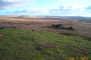
Helman Tor is a granite hill in mid Cornwall, UK with several separated tors, and is designated as a (non-statutory) County Geology Site. The hill also has a Scheduled Ancient Monument. Helman Tor is also the name of the largest nature reserve managed by the Cornwall Wildlife Trust which includes Breney Common and Red Moor. The Wildlife Trust aims to rewild the reserve, including potentially releasing beavers, as well as long-horn cattle and Cornish black pigs. Helman Tor, along with Breney Common, Red Moor and Belowda Beacon, is part of the Mid Cornwall Moors Site of Special Scientific Interest. It lies on the Saints' Way, a long-distance footpath completed in 1986.

Brown Willy is a hill in Cornwall, England, United Kingdom. The summit, at 1,378 feet above sea level, is the highest point of Bodmin Moor and of Cornwall as a whole. It is about 2+1⁄2 miles northwest of Bolventor and 4 miles southeast of Camelford. The hill has a variable appearance that depends on the vantage point from which it is seen. It bears the conical appearance of a sugarloaf from the north but widens into a long multi-peaked crest from closer range.

At 258 metres, Bell Hill is one of the highest hills in the county of Dorset, England and a high point on the Wessex Ridgeway.

Alex Tor is a conical hill, 291 metres (955 ft) high, located in the west of Bodmin Moor in the county of Cornwall, England.

Stowe's Hill is an elongated hill, 381 metres (1,250 ft) high, located on the eastern edge of Bodmin Moor in the county of Cornwall, England.

Watch Croft is a prominent hill, 252 metres (827 ft) high overlooking the north coast of the Cornwall, UK. Its prominence of 225 metres qualifies it as a Marilyn, one of only five in Cornwall. The others are Brown Willy, Kit Hill, Hensbarrow Beacon and Carnmenellis. It is the highest point in West Penwith.

Castle Downs is a dome-shaped hill, 216 metres (709 ft) high, located in mid Cornwall, UK. There is a major hillfort, Castle an Dinas, on the summit and extensive and panoramic views across the county to both north and south coasts.

The Devon Redlands is a natural region in southwest Britain that has been designated as National Character Area (NCA) 148 by Natural England.

Black Edge is a summit, 507 metres (1,663 ft) high, on a sharp ridgeline above the village of Dove Holes in the Dark Peak area of the Peak District in the county of Derbyshire in England.
Amicombe Hill, also known as the Devil's Dome, is a hill in North Dartmoor in the southwest English county of Devon. At 584 metres high, it is the sixth highest peak in Devon and Dartmoor.


