
Bodmin is a civil parish and historic town in Cornwall, England, United Kingdom. It is situated south-west of Bodmin Moor.

Bodmin Moor is a granite moorland in northeastern Cornwall, England. It is 208 square kilometres (80 sq mi) in size, and dates from the Carboniferous period of geological history. It includes Brown Willy, the highest point in Cornwall, and Rough Tor, a slightly lower peak. Many of Cornwall's rivers have their sources here. It has been inhabited since at least the Neolithic era, when primitive farmers started clearing trees and farming the land. They left their megalithic monuments, hut circles and cairns, and the Bronze Age culture that followed left further cairns, and more stone circles and stone rows. By medieval and modern times, nearly all the forest was gone and livestock rearing predominated.

St Columb Major is a town and civil parish in Cornwall, England, United Kingdom. Often referred to locally as St Columb, it is approximately seven miles (11 km) southwest of Wadebridge and six miles (10 km) east of Newquay The designation Major distinguishes it from the nearby settlement and parish of St Columb Minor on the coast. An electoral ward simply named St Columb exists with a population at the 2011 census of 5,050.
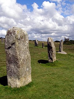
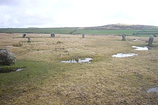
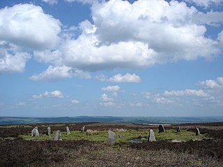
The Hurlers is a group of three stone circles in the civil parish of St Cleer, Cornwall, England, UK. The site is half-a-mile (0.8 km) west of the village of Minions on the eastern flank of Bodmin Moor, and approximately four miles (6 km) north of Liskeard at grid reference SX 258 714.

St Breward is a civil parish and village in Cornwall, England, United Kingdom. It is on the western side of Bodmin Moor, about 6 miles (10 km) north of Bodmin. At the 2011 census the parish population including Cooksland and Fentonadle was 919.
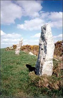
Nine Maidens stone row is an ancient monument in the parish of St Columb Major, Cornwall, England. The Nine Maidens are also known in Cornish as Naw-voz, or Naw-whoors meaning "The nine sisters". This late neolithic stone row is 2 miles (3.2 km) north of St Columb Major.
King Arthur's Hall is a megalithic enclosure on Bodmin Moor in Cornwall, England. It is thought to be a late Neolithic or early Bronze Age ceremonial site.

St Breock is a village and a civil parish in north Cornwall, England, United Kingdom. The spelling St Breoke was also formerly in use.

Cheetham Close is a megalithic site and scheduled ancient monument located in Lancashire, very close to the boundary with Greater Manchester, England. The megalith was in good condition until a farmer from Turton sledgehammered the circle in the 1870s. According to an article published in 1829, Cheetham Close was once a druidical ritual place and a Roman road passed 'within two hundred yards' of the megalith.

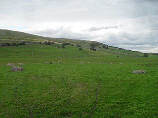
Craddock Moor Stone Circle or Craddock Moor Circle is a stone circle located near Minions on Bodmin Moor in Cornwall, UK. It is situated around half a mile Northwest of The Hurlers.

Fernacre, also known as Fernacre stone circle or Fernacre circle, is a stone circle located on the slopes of the De Lank River, 1.25 miles (2.01 km) northeast of St Breward on Bodmin Moor in Cornwall in the United Kingdom.

Machrie Moor Stone Circles is the collective name for six stone circles visible on Machrie Moor near the settlement of Machrie on the Isle of Arran, Scotland.
The Trippet stones or Trippet stones circle is a stone circle located on Manor Common in Blisland, 9 kilometres (5.6 mi) north northeast of Bodmin on Bodmin Moor in Cornwall, UK. The Stripple stones are nearby.

The Nine Stones is a stone circle located 3 kilometres (1.9 mi) south southeast of Altarnun, 11 kilometres (6.8 mi) west of Launceston on Bodmin Moor in Cornwall, UK.

Leaze stone circle is a stone circle located in the parish of St. Breward on Bodmin Moor in Cornwall, UK.

Hawk's Tor is a hill and tor on Bodmin Moor in Cornwall, England, UK. Its summit is 307 metres (1,007 ft) above sea level.
Gamelands stone circle is a stone circle at the foot of Knott Hill in Cumbria. The stones are mostly made of red granite and some were buried and blasted in 1862.

Barbrook One is a stone circle on Ramsley Moor in the Peak District.
The Twelve Apostles is a stone circle near Ilkley and Burley in Wharfedale in West Yorkshire, England.

Garrow Tor is a bare, tor-crowned hill, 330 metres (1,080 ft) high, located on Garrow Downs in the northwest of Bodmin Moor in the county of Cornwall, England, UK.

