
Until 1974, Glamorgan, or sometimes Glamorganshire, was an administrative county in the south of Wales, and later classed as one of the thirteen historic counties of Wales. Originally an early medieval petty kingdom of varying boundaries known in Welsh as Morgannwg, which was then invaded and taken over by the Normans as the Lordship of Glamorgan. The area that became known as Glamorgan was both a rural, pastoral area, and a conflict point between the Norman lords and the Welsh princes. It was defined by a large concentration of castles.

Port Talbot is a town and community in the county borough of Neath Port Talbot, Wales, situated on the east side of Swansea Bay, approximately eight miles from Swansea. The Port Talbot Steelworks covers a large area of land which dominates the south east of the town. It is one of the biggest steelworks in the world, but has been under threat of closure since the 1980s. The population was 31,550 in 2021, comprising about a fifth of the 141,931 population of Neath Port Talbot.

Rhondda, or the Rhondda Valley, is a former coalmining area in South Wales, historically in the county of Glamorgan. It takes its name from the River Rhondda, and embraces two valleys – the larger Rhondda Fawr valley and the smaller Rhondda Fach valley – so that the singular "Rhondda Valley" and the plural are both commonly used. The area forms part of the South Wales Valleys. From 1897 until 1996 there was a local government district of Rhondda. The former district at its abolition comprised sixteen communities. Since 1996 these sixteen communities of the Rhondda have been part of Rhondda Cynon Taf County Borough. The area of the former district is still used as the Rhondda Senedd constituency and Westminster constituency, having an estimated population in 2020 of 69,506. It is most noted for its historical coalmining industry, which peaked between 1840 and 1925. The valleys produced a strong Nonconformist movement manifest in the Baptist chapels that moulded Rhondda values in the 19th and early 20th centuries. It is also known for its male voice choirs and in sport and politics.

Pontrhydyfen is a small village in the Afan Valley, in Neath Port Talbot county borough in Wales. The village sits at the confluence of the River Afan and the smaller Afon Pelenna, 1.8 miles (2.9 km) north of the larger village of Cwmafan and not far from the towns of Port Talbot and Neath. The views from the village are dominated by the hills of Foel Fynyddau (370 m) to the west, Moel y Fen (260 m) to the south-east and Mynydd Pen-rhys (280 m) to the north. This former coal mining community is distinguished by two large 19th-century bridges that span the valley: a railway viaduct and a former aqueduct, known in the Welsh language as Y Bont Fawr. The built-up area has a population of around 830. It is in the community of Pelenna. There is both a Community Centre and rugby union club, Pontrhydyfen RFC.

Fan Brycheiniog is the highest peak at a height of 802.5 metres (2,633 ft) in the Black Mountain region of the Brecon Beacons National Park in southern Wales. There is a trig point at the peak and on the edge of the escarpment, and nearby, a stone shelter with an inner seat. It lies just inside the historic county of Brecknockshire which gives the mountain its Welsh name. A subsidiary top, less than a kilometre from the summit along the ridge to the northwest, is the highest point of the neighboring county of Carmarthenshire. Fan Brycheiniog is also within the Fforest Fawr Geopark designated in 2005 in recognition of the area's geological heritage. The views of the moorland and open country to the north are spectacular when the weather is clear, and reveals the isolation of the range, especially when compared with the more popular Pen y Fan range to the east.

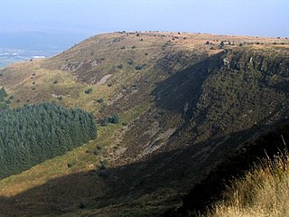
Cwmafan, also known as Cwmavon, is a large village and community in the Afan valley in Wales, lying within Neath Port Talbot County Borough. It had a population of 5,603 in 2001, increasing slightly to 5,615 at the 2011 Census. Cwmafan is known for having a high percentage of Welsh speakers. In many ways it is a suburb of the nearby town of Port Talbot which is less than 2 miles (3 km) to the south. The literal translation of Cwmafan from Welsh to English is complex, Cwm means valley with Afan as the name of the river flowing through, hence the village residing within the Afan Valley. It could be a version of Afon which means river, so literally the "River Valley", this is common in Wales and the UK with many rivers being called Afon or Avon. There is also a Saint Afan, which it is possible the river was named after. There have been other suggestions but none accepted locally.
The Black Mountain is a mountain range in South, Mid and West Wales, straddling the administrative boundary between Carmarthenshire and Powys and forming the westernmost range of the Brecon Beacons National Park. Its highest point is Fan Brycheiniog at 802 metres or 2,631 ft. The Black Mountain also forms a part of the Fforest Fawr Geopark.

Blaengwrach is a community near Glynneath and Resolven in the county borough of Neath Port Talbot, Wales. It is also the name of an electoral ward of Neath Port Talbot county borough, which is a larger area than the Community. The principal settlement is Cwmgwrach, a village on the south side of the Neath valley, of which the eastern end is called Blaengwrach, which sometimes causes confusion.
Craig y Llyn is a mountain situated to the south of the village of Rhigos in the Cynon Valley on the south side of the upper Vale of Neath and north of the Rhondda Valleys in South Wales; it is the highest point in the ancient kingdom and, later, county of Glamorgan (Morgannwg), and the southern Welsh coalfield plateau.

Cefn Coed Colliery Museum is a former coal mine, now operating as a museum. It is located at Crynant near Neath in the South Wales Valleys.

Fforest Fawr is an extensive upland area in the county of Powys, Wales. Formerly known as the Great Forest of Brecknock in English, it was a royal hunting area for several centuries but is now used primarily for sheep grazing, forestry, water catchment and recreation. It lies within the Brecon Beacons National Park.

Picws Du is the second highest peak of the Carmarthen Fans in the Carmarthenshire section of the Black Mountain in the west of the Brecon Beacons National Park in south Wales. The highest peak is Fan Foel immediately next along the ridge and it is a subsidiary summit of Fan Brycheiniog. Picws Du falls within Fforest Fawr Geopark and its prominent summit is marked by a large Bronze Age round barrow at a height of 2457 feet above sea level. Waun Lefrith is the other, lower summit of the Bannau Sir Gâr / Carmarthen Fans situated to the west. The peak overlooks the glacial lake of Llyn y Fan Fach in the cwm below. As the peak sits on the edge of the escarpment on a ridge which juts out into the valley below, the views from the summit are panoramic and extensive. The views to the north are especially impressive when the weather is clear, looking towards the Cambrian Mountains, Mynydd Epynt and Brecon. Swansea and the Bristol Channel can just be seen on the horizon to the south, across the gently falling dip slope. Pen y Fan and Corn Du are distinctive landmarks seen directly to the east across Fforest Fawr.
Hirfynydd is a 481-metre-high hill in Neath Port Talbot county borough in South Wales. A Roman road, Sarn Helen, runs along its entire northeast–southwest ridge-line, a route followed by a modern-day byway. To its west is Cwm Dulais and to its southeast is the Vale of Neath. The northern end of the ridge falls away to a broad upland vale containing the Afon Pyrddin and beyond which is the Brecon Beacons National Park.

Mynydd-y-Gaer is a hill that sits on the boundaries between the South Wales communities of Baglan, Cwmavon and Briton Ferry,, all within Neath Port Talbot county borough. The summit, at 314 m (1,030 ft), has grassland fields subdivided by dry stone walls. Foel Fynyddau lies 2 km to east. To the south is the coastal plain of the Bristol Channel. To the West is the Vale of Neath. To the north is the Crythan Brook and the town of Neath. It has numerous prehistoric monuments, and evidence of occupation in medieval times, as well as 19th and 20th century coalmining.
Buarth-y-Gaer is an Iron Age hillfort or enclosure on the summit of Mynydd-y-Gaer, 300 m (980 ft) above sea level. It is in Briton Ferry community, near Neath, in Neath Port Talbot, South Wales. A large hilltop enclosure is bounded by a single bank and ditch. Within the enclosed area is a Bronze Age burial mound.
