
Dartmoor is an upland area in southern Devon, England. The moorland and surrounding land has been protected by National Park status since 1951. Dartmoor National Park covers 954 km2 (368 sq mi).

The Mên-an-Tol is a small formation of standing stones in Cornwall, UK. It is about three miles northwest of Madron. It is also known locally as the "Crick Stone".

Beaghmore is a complex of early Bronze Age megalithic features, stone circles and cairns, 8.5 miles north west of Cookstown, County Tyrone in Northern Ireland, on the south-east edge of the Sperrin Mountains.
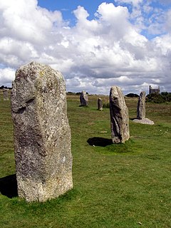
The Hurlers is a group of three stone circles in the civil parish of St Cleer, Cornwall, England, UK. The site is half-a-mile (0.8 km) west of the village of Minions on the eastern flank of Bodmin Moor, and approximately four miles (6 km) north of Liskeard at grid reference SX 258 714.

The Callanish Stones are an arrangement of standing stones placed in a cruciform pattern with a central stone circle. They were erected in the late Neolithic era, and were a focus for ritual activity during the Bronze Age. They are near the village of Callanish on the west coast of Lewis in the Outer Hebrides, Scotland.

Little Meg is a small circle of large kerb stones which probably surrounded a Bronze Age kerb cairn. It is close to the village of Langwathby to the north-east of Penrith in the English county of Cumbria and is 650 metres north-east of the more famous stone circle of Long Meg and Her Daughters. It forms part of a complex of stone circles and cairns around the Long Meg site that includes the circle at Glassonby, Old Parks, and other sites since lost.

Boskednan stone circle is a partially restored prehistoric stone circle near Boskednan, around 4 miles northwest of the town of Penzance in Cornwall, United Kingdom. The megalithic monument is traditionally known as the Nine Maidens or Nine Stones of Boskednan, although the original structure may have contained as many as 22 upright stones around its 69-metre perimeter.

The Bridestones is a chambered cairn, near Congleton, Cheshire, England, that was constructed in the Neolithic period about 3500–2400 BC. It was described in 1764 as being 120 yards (110 m) long and 12 yards (11 m) wide, containing three separate compartments, of which only one remains today. The remaining compartment is 6 metres (20 ft) long by 2.7 metres (8.9 ft) wide, and consists of vertical stone slabs, divided by a now-broken cross slab. The cairn originally had a stone circle surrounding it, with four portal stones; two of these portal stones still remain. The site is protected as a scheduled ancient monument.
ScorhillStone Circle is now the commonly known name for Gidleigh Stone Circle or Steep Hill Stone Circle, one of Devon's biggest and most intact stone circles, situated on Gidleigh Common near the village of Gidleigh in the north east of Dartmoor, in the United Kingdom. It is an English Heritage scheduled monument and has been described as Devon's finest stone circle.

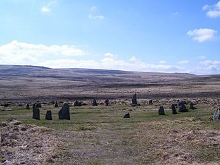
Fernacre, also known as Fernacre stone circle or Fernacre circle, is a stone circle located on the slopes of the De Lank River, 1.25 miles (2.01 km) northeast of St Breward on Bodmin Moor in Cornwall in the United Kingdom.

Machrie Moor Stone Circles is the collective name for six stone circles visible on Machrie Moor near the settlement of Machrie on the Isle of Arran, Scotland.

Goodaver, Goodaver stone circle or Goodaver circle is a stone circle located in the parish of Altarnun, near Bolventor on Bodmin Moor in Cornwall, UK.

Hordron Edge stone circle, also known as 'The Seven Stones of Hordron' is a Bronze Age stone circle in Derbyshire, England. It is on the edge of Moscar Moor. Ladybower reservoir is to the west, and Moscar Cross is to the northeast. Seven stones are presently (2017) visible with a further three stones, now recumbent and hidden discovered in 1992. Some authorities believe that the circle might have once comprised 26 stones.

Cornish promontory forts, commonly known in Cornwall as cliff castles, are coastal equivalents of the hill forts and Cornish "rounds" found on Cornish hilltops and slopes. Similar coastal forts are found on the north–west European seaboard, in Normandy, Brittany and around the coastlines of the British Isles, especially in Wales, Scotland and Ireland. Many are known in southwest England, particularly in Cornwall and its neighbouring county, Devon. Two have been identified immediately west of Cornwall, in the Isles of Scilly.
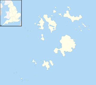
Castle Down is a windswept plateau of maritime heath in the northern part of the island of Tresco, Isles of Scilly. The area has a number of designations including Castle Down (Tresco) Site of Special Scientific Interest (SSSI); is part of the Isles of Scilly Area of Outstanding Natural Beauty; part of the Isles of Scilly Heritage Coast; and part of Plantlife's Isles of Scilly Important Plant Area. There are a number of Schedule Ancient Monument's ranging in age from Bronze Age cairns to castles built in the 16th and 17th centuries to protect the anchorage of New Grimsby harbour.

Ringmoor stone row and cairn circle is a prehistoric stone row and cairn circle on Ringmoor Down in Devon. It is located three miles east of the A386, northeast of the village of Shaugh Prior. It is three hundred metres north from Brisworthy stone circle, and is one of the archaeological sites found in the Upper Plym Valley.

Rempstone Stone Circle is a stone circle located near to Corfe Castle on the Isle of Purbeck in the south-western English county of Dorset. Archaeologists believe that it was likely erected during the Bronze Age. The Rempstone ring is part of a tradition of stone circle construction that spread throughout much of Britain, Ireland, and Brittany during the Late Neolithic and Early Bronze Age, over a period between 3,300 and 900 BCE. The purpose of such monuments is unknown, although archaeologists speculate that they were likely religious sites, with the stones perhaps having supernatural associations for those who built the circles. Local folklore holds that the stones arrived in their position after being thrown at Corfe Castle by the Devil.

The Shap Stone Avenue is a megalithic complex near Shap in Cumbria comprising stone circles, a two-mile avenue of stones, and burial mounds.

Porlock Stone Circle is a stone circle located on Exmoor, near the village of Porlock in the south-western English county of Somerset. The Porlock ring is part of a tradition of stone circle construction that spread throughout much of Britain, Ireland, and Brittany during the Late Neolithic and Early Bronze Age, over a period between 3,300 and 900 BCE. The purpose of such monuments is unknown, although archaeologists speculate that the stones represented supernatural entities for the circles' builders.

Withypool Stone Circle, also known as Withypool Hill Stone Circle, is a stone circle located on the Exmoor moorland, near the village of Withypool in the southwestern English county of Somerset. The ring is part of a tradition of stone circle construction that spread throughout much of Britain, Ireland, and Brittany during the Late Neolithic and Early Bronze Age, over a period between 3300 and 900 BCE. The purpose of such monuments is unknown, although archaeologists speculate that the stones represented supernatural entities for the circle's builders.


