Rempstone Stone Circle

Last updated

Rempstone Stone Circle
Part of the Rempstone stone circle in birch woodland, Purbeck - geograph.org.uk - 25149.jpg
Stones from the Rempstone Stone Circle amid the woodland
Dorset UK location map.svg
Archaeological site icon (red).svg
Shown within Dorset
Location Isle of Purbeck
Coordinates 50°38′19″N2°00′32″W / 50.6385°N 2.0089°W / 50.6385; -2.0089 Coordinates: 50°38′19″N2°00′32″W / 50.6385°N 2.0089°W / 50.6385; -2.0089
Type Stone circle
History
Periods Neolithic / Bronze Age

Rempstone Stone Circle (grid reference SY994820 ) is a stone circle located near to Corfe Castle on the Isle of Purbeck in the south-western English county of Dorset. Archaeologists believe that it was likely erected during the Bronze Age. The Rempstone ring is part of a tradition of stone circle construction that spread throughout much of Britain, Ireland, and Brittany during the Late Neolithic and Early Bronze Age, over a period between 3,300 and 900 BC. The purpose of such monuments is unknown, although archaeologists speculate that they were likely religious sites, with the stones perhaps having supernatural associations for those who built the circles. Local folklore holds that the stones arrived in their position after being thrown at Corfe Castle by the Devil.

Contents

A number of these circles were built in the area around modern Dorset, typically being smaller than those found elsewhere. Most of these Dorset circles are made of sarsen stone, although the Rempstone circle is unique in being made from local sandstone. The southern half of the circle has been destroyed, with five upright and three recumbent stones remaining extant. Having been damaged by eighteenth century clay workings, the monument is at present situated within dense woodland. In 1957, a possible avenue of stones leading to the circle was discovered by ploughing but subsequently removed.

Location

Rempstone Stone Circle is positioned at the national grid reference 39940821. [1] The incomplete stone circle lies in a dense wood just to the south of the B3351 road, 4 kilometres (2.5 mi) east of Corfe Castle and 5 kilometres (3.1 mi) west of Studland. [2] It is located at the foot of Nine Barrows Down, at a height of 278 feet (85 m) above sea level. [3] It is 0.5 miles (800 m) south of Rempstone Lodge. [3] As with the Nine Stones at Winterbourne Abbas, the Rempstone Stone Circle is located in a valley. [3] The land on which the site sits is privately owned, [1] and is accorded legal protection under the Ancient Monuments and Archaeological Areas Act 1979. [4]

Context

While the transition from the Early Neolithic to the Late Neolithic—which took place with the transition from the fourth to the third millennium BC—witnessed much economic and technological continuity, it also saw a considerable change in the style of monuments erected, particularly in southern and eastern England. [5] By 3000 BC, the long barrows, causewayed enclosures, and cursuses which had predominated in the Early Neolithic had ceased being built, and were instead replaced by circular monuments of various kinds. [5] These include earthen henges, timber circles, and stone circles. [6] These latter circles are found in most areas of Britain where stone is available, with the exception of the island's south-eastern corner. [7] They are most densely concentrated in south-western Britain and on the north-eastern horn of Scotland, near Aberdeen. [7] The tradition of their construction may have lasted for 2,400 years, from 3300 to 900 BC, with the major phase of building taking place between 3000 and 1,300 BC. [8]

These stone circles typically show very little evidence of human visitation during the period immediately following their creation. [9] This suggests that they were not sites used for rituals that left archaeologically visible evidence, and may have been deliberately left as "silent and empty monuments". [10] The archaeologist Mike Parker Pearson suggested that in Neolithic Britain, stone was associated with the dead and wood with the living. [11] Other archaeologists have suggested that the stone might not represent ancestors, but rather other supernatural entities, such as deities. [10]

The area of modern Dorset has only a "thin scatter" of stone circles, [12] with nine possible examples known within its boundaries. [13] The archaeologist John Gale described these as "a small but significant group" of such monuments, [13] and all are located within five miles of the sea. [14] Of the Dorset circles, Rempstone is the only example that is not located on the chalk hills west of Dorchester. [15] The Dorset circles have a simplistic typology, being of comparatively small size, with none exceeding 28 metres (92 feet) in diameter. [16] All are oval in shape, although perhaps have been altered from their original form. [17] The Rempstone circle is exceptional among these, as it is the only one which does not consist of sarsen stone. [15] However, like all the others—with the exception of the circle at Litton Cheney—it does not display evidence of any outlying stones or earthworks. [18]

The archaeologists Stuart and Cecily Piggott believed that the circles of Dorset were probably of Bronze Age origin, [19] a view endorsed by the archaeologist Aubrey Burl, who noted that their distribution did not match that of any known Neolithic sites. [20] It is possible that they were not all constructed around the same date, [21] and the Piggotts suggested that while they may well be Early Bronze Age in date, it is also possible that "their use and possibly their construction may last into the Middle and even into the Late Bronze Age". [19] Their nearest analogies are the circles found on Dartmoor and Exmoor to the west, and the Stanton Drew stone circles to the north. [22] It is also possible that the stone circles were linked to a number of earthen henges erected in Dorset around the same period. [19]

Description

Plan of Rempstone Stone Circle (based on that published by Piggott and Piggott in 1939) Rempstone Stone Circle plan.png
Plan of Rempstone Stone Circle (based on that published by Piggott and Piggott in 1939)

Burl has noted that Rempstone Stone Circle is "damaged and overgrown". [14] Similarly, Gale stated that "the description and evaluation of this site [is] very difficult" on account of it being "much disturbed". [23] Eight stones survive; five are standing, while three more are recumbent. [24] The standing stones vary in size, [3] and are irregularly shaped. [25] The stones are sandstone boulders which geologically belong to the Bagshot Beds, on which the circle is located. [26]

The southern half of the circle has been destroyed, [3] likely by clay workings that took place in the area during the late eighteenth century. [23] At the south-west of the site, three more stones are visible but half-buried; these may not be in their original position. [3] The west side of the site is cut by pools and ditches formed by old clay workings. [27] The surviving stones form an arc that suggests that the circle originally had a diameter of about 26 metres, [23] or 80 feet. [3] If this was the case then it would have been the second largest stone circle in Dorset, after Kingston Russell Stone Circle. [23]

The circle was included in the archaeologist O. G. S. Crawford's Map of Neolithic Wessex, printed by the Ordnance Survey in 1932. In this publication, the site was erroneously assigned co-ordinates of the Breamore Wood Long Barrow. [3] As of 2003, the site had not been excavated. [13]

In August 1957, the local farmer W. G. Best was ploughing on his Brenscombe Farm when he uncovered a row of 23 stones that was situated about 0.5 miles (800 m) west of Rempstone Stone Circle. His son stood most of these into an upright position, to better assist their later removal. The antiquarian J. Bernard Calkin was alerted to the discovery and visited it prior to the stones being removed by the farmer. [28] Calkin noted that the stones were made of local sandstone and were smaller than the stones in the circle, averaging about 2 feet 6 inches by 1 foot 6 inches. [28] He believed that they had been deliberately lain out in two parallel lines, 3 yards apart and with an interval of five yards between each stone. [28] Calkin suggested that this may have been a stone avenue or processional way leading to the circle. [28] Burl later expressed scepticism with regard to this interpretation, stating that its "credentials are suspect". [14]

90 feet (27 m) east of the circle is a group of eight stones which may have had some relationship to the circle. [29] There is also a cluster of barrows, known as "Nine Barrows", on the hill immediately to the south of the stone circle. [30] [31]

Folklore

After the monument was discovered and identified in the twentieth century, a folk motif came to be associated with it. [32] According to this story, the circle's stones had landed in their location after having been hurled at Corfe Castle by the Devil. [32] This is a variant of a story that has also been connected to the Agglestone Rock near Studland. According to stories associated with this large sandstone block, it had been thrown by the Devil from The Needles on the Isle of Wight, with the intention of hitting either the castle, Sherborne Abbey, Bindon Abbey, or Salisbury Cathedral. [32]

Related Research Articles

Avebury Neolithic henge monument in Wiltshire, England

Avebury is a Neolithic henge monument containing three stone circles, around the village of Avebury in Wiltshire, in southwest England. One of the best known prehistoric sites in Britain, it contains the largest megalithic stone circle in the world. It is both a tourist attraction and a place of religious importance to contemporary pagans.

West Kennet Long Barrow Neolithic tomb or barrow in Wiltshire, England

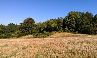
The West Kennet Long Barrow, also known as South Long Barrow, is a chambered long barrow near the village of Avebury in the south-western English county of Wiltshire. Probably constructed in the thirty-seventh century BC, during Britain's Early Neolithic period, today it survives in a partially reconstructed state.

The Sanctuary Prehistoric site in Wiltshire, England

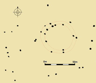
The Sanctuary was a stone and timber circle near the village of Avebury in the south-western English county of Wiltshire. Excavation has revealed the location of the 58 stone sockets and 62 post-holes. The ring was part of a tradition of stone circle construction that spread throughout much of Britain, Ireland, and Brittany during the Late Neolithic and Early Bronze Age, over a period between 3300 and 900 BCE. The purpose of such monuments is unknown, although archaeologists speculate that the stones represented supernatural entities for the circle's builders.

Little Kits Coty House Dolmen in England

Little Kit's Coty House, also known as Lower Kit's Coty House and the Countless Stones, is a chambered long barrow located near to the village of Aylesford in the southeastern English county of Kent. Constructed circa 4000 BCE, during the Early Neolithic period of British prehistory, today it survives in a ruined state.

Chestnuts Long Barrow Chambered long barrow in Kent, England

Chestnuts Long Barrow, also known as Stony Warren or Long Warren, is a chambered long barrow near the village of Addington in the south-eastern English county of Kent. Probably constructed in the fifth millennium BC, during Britain's Early Neolithic period, today it survives only in a ruined state.

Addington Long Barrow Chambered long barrow in Kent, England

Addington Long Barrow is a chambered long barrow located near the village of Addington in the southeastern English county of Kent. Probably constructed in the fourth millennium BCE, during Britain's Early Neolithic period, today it survives only in a ruined state. Built of earth and about fifty local sarsen megaliths, the long barrow consisted of a sub-rectangular earthen tumulus enclosed by kerb-stones. Collapsed stones on the northeastern end of the chamber probably once formed a stone chamber in which human remains might have been deposited, though none have been discovered.

Julliberries Grave Long barrow in Kent, England

Julliberrie's Grave, also known as The Giant's Grave or The Grave, is an unchambered long barrow located near to the village of Chilham in the south-eastern English county of Kent. Probably constructed in the fourth millennium BCE, during Britain's Early Neolithic period, today it survives only in a state of ruin.

Doll Tor Bronze age stone circle in Derbyshire

Doll Tor is a stone circle located just to the west of Stanton Moor, near the village of Birchover, Derbyshire in the English East Midlands. Doll Tor is part of a tradition of stone circle construction that spread throughout much of Britain, Ireland, and Brittany during the Late Neolithic and Early Bronze Ages, over a period between 3300 and 900 BCE. The purpose of such monuments is unknown, although archaeologists speculate that the stones represented supernatural entities for the circles' builders.

Stone circles in the British Isles and Brittany Megalithic tradition of monuments

The stone circles in the British Isles and Brittany are a megalithic tradition of monuments consisting of standing stones arranged in rings. These were constructed from 3300 to 900 BCE in Britain, Ireland and Brittany. It has been estimated that around 4,000 of these monuments were originally constructed in this part of north-western Europe during this period. Around 1,300 of them are recorded, the others having been destroyed.

Nine Stones Close Bronze age stone circle in England

Nine Stones Close, also known as the Grey Ladies, is a Bronze Age stone circle located near Youlgreave in Derbyshire. It sits within a local prehistoric landscape that includes Bronze Age barrows and settlement enclosures, and is part of a tradition of stone circle construction that spread throughout much of Britain, Ireland, and Brittany during the Late Neolithic and Early Bronze Ages, over a period between 3300 and 900 BCE. The purpose of the monument is unknown, although archaeologists have speculated that the stones represented supernatural entities.

Nine Stones, Winterbourne Abbas Stone circle in Dorset, southwestern England

The Nine Stones, also known as the Devil's Nine Stones, the Nine Ladies, or Lady Williams and her Dog, is a stone circle located near to the village of Winterbourne Abbas in the southwestern English county of Dorset. Archaeologists believe that it was likely erected during the Bronze Age.

Kingston Russell Stone Circle Stone circle in Dorset, England

Kingston Russell Stone Circle, also known as the Gorwell Circle, is a stone circle located between the villages of Abbotsbury and Littlebredy in the south-western English county of Dorset. Archaeologists believe that it was likely erected during the Bronze Age. The Kingston Russell ring is part of a tradition of stone circle construction that spread throughout much of Britain, Ireland, and Brittany during the Late Neolithic and Early Bronze Age, over a period between 3,300 and 900 BCE. The purpose of such monuments is unknown, although archaeologists speculate that they were likely religious sites, with the stones perhaps having supernatural associations for those who built the circles.

Hampton Down Stone Circle Bronze Age construction in Dorset, England

The Hampton Down Stone Circle is a stone circle located near to the village of Portesham in the south-western English county of Dorset. Archaeologists believe that it was likely erected during the Bronze Age. The Hampton Down ring is part of a tradition of stone circle construction that spread throughout much of Britain, Ireland, and Brittany during the Late Neolithic and Early Bronze Age, over a period between 3,300 and 900 BCE. The purpose of such monuments is unknown, although archaeologists speculate that they were likely religious sites, with the stones perhaps having supernatural associations for those who built the circles. However, it has been suggested that the site is not a stone circle at all, but is instead made up of kerbstones from a Bronze Age round barrow.

Porlock Stone Circle Neolithic stone circle in Somerset, England

Porlock Stone Circle is a stone circle located on Exmoor, near the village of Porlock in the south-western English county of Somerset. The Porlock ring is part of a tradition of stone circle construction that spread throughout much of Britain, Ireland, and Brittany during the Late Neolithic and Early Bronze Age, over a period between 3300 and 900 BCE. The purpose of such monuments is unknown, although archaeologists speculate that the stones represented supernatural entities for the circles' builders.

Withypool Stone Circle Late neolithic stone circle in Somerset, England

Withypool Stone Circle, also known as Withypool Hill Stone Circle, is a stone circle located on the Exmoor moorland, near the village of Withypool in the southwestern English county of Somerset. The ring is part of a tradition of stone circle construction that spread throughout much of Britain, Ireland, and Brittany during the Late Neolithic and Early Bronze Age, over a period between 3300 and 900 BCE. The purpose of such monuments is unknown, although archaeologists speculate that the stones represented supernatural entities for the circle's builders.

Badshot Lea Long Barrow, also known as Farnham Long Barrow, was an unchambered long barrow located near the village of Badshot Lea in the south-eastern English county of Surrey. It was probably constructed in the fourth millennium BCE, during Britain's Early Neolithic period.

Fir Clump Stone Circle Neolithic stone circle in Wiltshire, England

Fir Clump Stone Circle was a stone circle in Burderop Wood near Wroughton, Wiltshire, in South West England. The ring was part of a tradition of stone circle construction that spread throughout much of Britain, Ireland, and Brittany during the Late Neolithic and Early Bronze Age, over a period between 3300 and 900 BCE. The purpose of such monuments is unknown, although some archaeologists speculate that the stones represented supernatural entities for the circle's builders.

Clatford Stone Circle, also known as The Broadstones, was a stone circle located in the village of Clatford in the south-western English county of Wiltshire.

Tisbury Stone Circle and Henge was a stone circle and henge in the south-western English county of Wiltshire. Archaeologists believe that it was likely erected during the Bronze Age.

Broome Stone Circle was a stone circle located in the south-western English county of Wiltshire. The ring was part of a tradition of stone circle construction that spread throughout much of Britain, Ireland, and Brittany during the Late Neolithic and Early Bronze Age, over a period between 3300 and 900 BCE. The purpose of such monuments is unknown, although archaeologists speculate that the stones represented supernatural entities for the circle's builders.

References

Footnotes

  1. 1 2 Gale 2003, p. 176.
  2. Piggott & Piggott 1939, p. 148; Gale 2003, p. 176.
  3. 1 2 3 4 5 6 7 8 Piggott & Piggott 1939, p. 148.
  4. Historic England. "Rempstone Stone Circle (1018186)". National Heritage List for England . Retrieved 4 November 2016.
  5. 1 2 Hutton 2013, p. 81.
  6. Hutton 2013, pp. 91–94.
  7. 1 2 Hutton 2013, p. 94.
  8. Burl 2000, p. 13.
  9. Hutton 2013, p. 97.
  10. 1 2 Hutton 2013, p. 98.
  11. Hutton 2013, pp. 97–98.
  12. Burl 2000, p. 307.
  13. 1 2 3 Gale 2003, p. 72.
  14. 1 2 3 Burl 2000, p. 308.
  15. 1 2 Piggott & Piggott 1939, p. 138.
  16. Piggott & Piggott 1939, p. 139; Burl 2000, p. 308; Gale 2003, p. 72.
  17. Burl 2000, p. 308; Gale 2003, p. 72.
  18. Piggott & Piggott 1939, p. 139.
  19. 1 2 3 Piggott & Piggott 1939, p. 142.
  20. Burl 2000, p. 310.
  21. Piggott & Piggott 1939, p. 141.
  22. Piggott & Piggott 1939, p. 140.
  23. 1 2 3 4 Gale 2003, p. 175.
  24. Piggott & Piggott 1939, p. 148; Calkin 1960, p. 114; Gale 2003, p. 175.
  25. Calkin 1960, p. 114; Gale 2003, p. 175.
  26. Piggott & Piggott 1939, p. 148; Calkin 1960, p. 114; Gale 2003, pp. 175, 176.
  27. Historic England. "Rempstone Stone Circle (456759)". Research records (formerly PastScape). Retrieved 13 November 2013.
  28. 1 2 3 4 Calkin 1960, p. 114.
  29. Piggott & Piggott 1939, p. 148; Calkin 1960, p. 114.
  30. Calkin 1960, p. 115.
  31. Historic England. "Monument No. 456762". Research records (formerly PastScape). Retrieved 13 November 2013.
  32. 1 2 3 Harte 1986, p. 73.

Bibliography

  • Burl, Aubrey (2000). The Stone Circles of Britain, Ireland and Brittany . New Haven and London: Yale University Press. ISBN   978-0-300-08347-7.
  • Calkin, J. B. (1960). "Some Archaeological Discoveries in the Isle of Purbeck, Part 2". Proceedings of the Dorset Natural History and Archaeological Society. 81: 114–123.
  • Gale, John (2003). Prehistoric Dorset. Stroud: Tempus. ISBN   978-0-7524-2906-9.
  • Harte, Jeremy (1986). Cuckoo Pounds and Singing Barrows: The Folklore of Ancient Sites in Dorset. Dorchester: Dorset Natural History & Archaeological Society. ISBN   0-900341-23-8.
  • Hutton, Ronald (2013). Pagan Britain. New Haven and London: Yale University Press. ISBN   978-0-300-19771-6.
  • Piggott, Stuart; Piggott, C. M. (1939). "Stone and Earth Circles in Dorset". Antiquity. 13 (50): 138–158. doi:10.1017/S0003598X00027861.