River Brit

Last updated

River Brit
Palmers Brewery - geograph.org.uk - 1232454.jpg
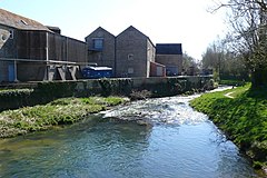
River Brit at Palmers Brewery, Bridport
Dorset UK relief location map.jpg
Red pog.svg
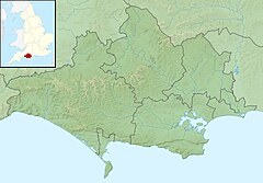
Location within Dorset
Location
Country England
County Dorset
District West Dorset
Towns and villages West Bay, Bridport, Netherbury, Beaminster
Physical characteristics
Source Beaminster
  location Dorset, England
Mouth  
  location
West Bay, West Dorset, Dorset, England
  coordinates
50°42′32″N2°45′50″W / 50.7089°N 2.7638°W / 50.7089; -2.7638
Length15.17 km (9.43 mi)
Discharge 
  location West Bay
Basin features
Tributaries 
  left River Asker
  rightRiver Simene

The River Brit is a river in west Dorset in south-west England, which rises just to the north of Beaminster. It then flows south to Netherbury and Bridport, where it is joined by tributaries: the River Simene and River Asker. South of Bridport, it reaches Lyme Bay on the English Channel coast, at West Bay. [1] The Brit has a length of 9.43 miles (15.17 km). [2]

Contents

Name

The river takes its name from the town of Bridport, which in turn derives from the River Bride, the neighbouring drainage basin to the east, which has connections with Bridport's early history. Before the establishment of Bridport, the Brit was named the River Wooth. This is still reflected in the names of settlements, such as Wooth Manor and Camesworth. [3]

Natural history

The river has Indian balsam plants on its banks. [4] It was previously polluted by the local hemp and flax industries and by sewage discharges, but the environment of the river has improved in recent years. Fish species found include the stone loach, brown trout and minnows. These in turn support wildlife such as kingfishers and otters. Conditions are healthy enough to support the parr of salmon and sea trout, which live in the river for two to five years before turning into smolt and returning to the sea; fish passes have been installed to facilitate this. [1]

Related Research Articles

<span class="mw-page-title-main">Dorset</span> County of England

Dorset is a ceremonial county in South West England. It is bordered by Somerset to the north-west, Wiltshire to the north and the north-east, Hampshire to the east, the Isle of Wight across the Solent to the south-east, the English Channel to the south, and Devon to the west. The largest settlement is Bournemouth, and the county town is Dorchester.

<span class="mw-page-title-main">River Axe (Lyme Bay)</span> River in southwest England

The River Axe is a 22-mile (35 km) long river in the counties of Dorset, Somerset and Devon, in the south-west of England. It rises in Dorset and flows south to Lyme Bay which it enters through the Axe Estuary in Devon. It is a shallow, non-navigable river, although its mouth at Seaton has some boating activity. The name Axe derives from a Common Brittonic word meaning "abounding in fish", and is cognate with pysg, the Welsh word for fish.

<span class="mw-page-title-main">Jurassic Coast</span> World Heritage Site on the coast of southern England

The Jurassic Coast is a World Heritage Site on the English Channel coast of southern England. It stretches from Exmouth in East Devon to Studland Bay in Dorset, a distance of about 96 miles (154 km), and was inscribed on the World Heritage List in mid-December 2001.

<span class="mw-page-title-main">Bridport</span> Town in Dorset, England

Bridport is a market town in Dorset, England, 2 miles (3.2 km) inland from the English Channel near the confluence of the River Brit and its tributary the Asker. Its origins are Saxon and it has a long history as a rope-making centre. On the coast and within the town's boundary is West Bay, a small fishing harbour also known as Bridport Harbour.

<span class="mw-page-title-main">Beaminster</span> Human settlement in England

Beaminster is a town and civil parish in Dorset, England, situated in the Dorset Council administrative area approximately 15 miles (24 km) northwest of the county town Dorchester. It is sited in a bowl-shaped valley near the source of the small River Brit. The 2013 mid-year estimate of the population of Beaminster parish is 3,100.

<span class="mw-page-title-main">West Bay, Dorset</span> English resort and harbour

West Bay, originally known as Bridport Harbour, is a small harbour settlement and resort on the English Channel coast in Dorset, England, sited at the mouth of the River Brit approximately 1.5 miles (2.4 km) south of Bridport. The area is part of the Jurassic Coast, a World Heritage Site.

<span class="mw-page-title-main">Netherbury</span> Village in Dorset, England

Netherbury is a village and civil parish in the English county of Dorset. It lies within the Dorset Council administrative area, by the small River Brit, 1.5 miles (2.4 km) south of Beaminster and 4 miles (6.4 km) north of Bridport. The A3066 road connecting those towns lies 0.5 miles to the east.

<span class="mw-page-title-main">Burton Bradstock</span> Human settlement in England

Burton Bradstock is a village and civil parish in Dorset, England, approximately 2+12 miles (4 km) southeast of Bridport and 12 mile (0.8 km) inland from the English Channel at Chesil Beach. In the 2011 Census the parish had a population of 948. The village lies in the Bride Valley, close to the mouth of the small River Bride. It comprises 16th- and 17th-century thatched cottages, a parish church, two pubs, a primary school, shop, post office stores, beach café, hotel, garage, village hall, reading room a library. The parish has a National Coastwatch Institution Station, Lyme Bay Station.

<span class="mw-page-title-main">Maiden Newton</span> Village in Dorset, England

Maiden Newton is a village and civil parish in the county of Dorset in south-west England. It lies within the Dorset Council administrative area, about 9 miles (14 km) north-west of the county town, Dorchester.

<span class="mw-page-title-main">Long Bredy</span> Human settlement in England

Long Bredy is a village and civil parish in the county of Dorset in south-west England, situated approximately 7 miles (11 km) west of the county town Dorchester. It is sited in the valley of the small River Bride, beneath chalk hills of the Dorset Downs. In the 2011 census the parish had a population of 208.

<span class="mw-page-title-main">Powerstock</span> Village and civil parish in Dorset, England

Powerstock is a village and civil parish in south west Dorset, England, situated in a steep valley on the edge of the Dorset Downs, 5 miles (8 km) north-east of the market town of Bridport. The civil parish includes the village of West Milton to the west and the summit and northern slopes of Eggardon Hill to the south-east. Powerstock village contains many cottages and two inns: The Three Horseshoes near the church and The Marquis of Lorne Inn on the other side of the valley in a small hamlet called Nettlecombe. The small Mangerton River runs through the valley.

<span class="mw-page-title-main">Littlebredy</span> Village in Dorset, England

Littlebredy is a small village and civil parish in the English county of Dorset, situated approximately 6.5 miles (10.5 km) west of the county town Dorchester. It is sited at the head of the valley of the small River Bride, surrounded by wooded chalk hills of the Dorset Downs. The parish contains the Valley of Stones National Nature Reserve and is in an area rich with evidence of early human occupation. In the 2011 census it had a population of 121.

The Bridport Railway was a railway branch line that operated in the county of Dorset in England. It connected Bridport with the main line network at Maiden Newton, and opened on 12 November 1857. It was extended to West Bay in 1884, but the extension was not well used and it closed to passengers in 1930.

<span class="mw-page-title-main">River Asker</span> River in Dorset, England

The River Asker is a small river in Dorset, England. It rises on the chalk slopes of Eggardon Hill, approximately five miles (8 km) east of Bridport. It flows west-northwest through the villages of Askerswell to which it gives its name, Uploders, where many cottages have gardens backing onto the river, and Loders. Here it heads west towards Bradpole, where it is joined by the small Mangerton Brook flowing in from the north. It then flows southwest into Bridport, passing underneath the A3066 and B3162 roads in the town. In this section there are weirs and fish ladders. South of the B3162, between Bridport and Bothenhampton, the river also forms the western boundary of the Askers Meadow Nature Reserve, which was designated a Local Nature Reserve in 2004. The river then flows under the B3157 road and joins the River Brit beside Palmers Brewery in the south of the town.

<span class="mw-page-title-main">Transport in Dorset</span>

Dorset is a county in South West England. The county is largely rural and therefore does not have a dense transport network, and is one of the few English counties without a motorway. Owing to its position on the English Channel coast, and its natural sheltered harbours, it has a maritime history, though lack of inland transport routes have led to the decline of its ports.

Water Polo has a long and distinguished history in Dorset, and is arguably the location for the world's first ever structured Water Polo match - held in 1876 off Bournemouth Pier.

<span class="mw-page-title-main">Geography of Dorset</span>

Dorset is a county located in the middle of the south coast of England. It lies between the latitudes 50.512°N and 51.081°N and the longitudes 1.682°W and 2.958°W, and occupies an area of 2,653 km2. It spans 90 kilometres (56 mi) from east to west and 63 kilometres (39 mi) from north to south.

<span class="mw-page-title-main">River Bride, Dorset</span> River in Dorset, England

The River Bride is a river in Dorset, England, situated between the towns of Dorchester and Bridport. It is approximately 6.5 miles (10.5 km) long and has a catchment area of 15 square miles (39 km2). It rises at an altitude of 90 metres (300 ft) beneath an artificial lake at Bridehead House, Littlebredy, then flows west to its mouth on the English Channel near Burton Bradstock. It has nine tributaries and descends more than 60 metres (200 ft) in its first three miles. It reaches the coast just west of Burton Bradstock through a break in coastal cliffs at Burton Freshwater; here it meets the western end of Chesil Beach where it "forms itself into a pool and fights to get to the sea intact before sinking into the shingle."

<span class="mw-page-title-main">River Lym</span> River in Dorset, England

The River Lym or River Lim is a short river, some 5 km in length, that flows through the Devon-Dorset border. It rises from multiple springs at Raymond's Hill, near the village of Uplyme in East Devon, and flows southeasterly through Dorset, into the English Channel via Lyme Bay in the town of Lyme Regis, Dorset. The river falls over 200 metres from its source.

<span class="mw-page-title-main">Mangerton River</span> River in Dorset, England

The Mangerton River or Mangerton Brook is a 13.37 km long river in Dorset, England that is a tributary of the River Asker. The river rises at Powerstock and flows westward through the small village of West Milton, then southward through the hamlet Mangerton, before flowing into the River Asker at Bradpole, near Bridport, which itself flows into the River Brit. It also flows through the West Dorset Alder Woods protected area.

References

  1. 1 2 Frome, Piddle & West Dorset Fisheries Association Retrieved 22 May 2017.
  2. Geoview Retrieved 9 June 2020.
  3. C. J. Bailey (1982). "Extracts from C.J. Bailey's Book "The Bride Valley"". www.burtonbradstock.org.uk. Retrieved 5 March 2014.
  4. Dorset Life magazine - the flowers of Dorset's riversides