1643

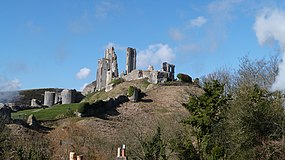
Mary Bankes was a Royalist who defended Corfe Castle from a three-year siege inflicted by the parliamentarians.
Portland Castle was captured by a group of Royalists who gained access by pretending to be Parliamentary soldiers. [4]
Dorset was a significant area in the English Civil War . Significant sieges include those at Corfe Castle and Sherborne Castle. [1]
Dorset was majority Royalist, except for in Lyme Regis and in Poole. [2]
The Battle of Babylon Hill was fought at Babylon Hill in 1642, but the conflict was inconclusive. [3]

Mary Bankes was a Royalist who defended Corfe Castle from a three-year siege inflicted by the parliamentarians.
Portland Castle was captured by a group of Royalists who gained access by pretending to be Parliamentary soldiers. [4]
The Siege of Lyme Regis was an eight-week blockade of Lyme Regis.
The Battle of Weymouth took place. [5]
The Battle of Lostwithiel took place over a 13-day period from 21 August to 2 September 1644, around the town of Lostwithiel and along the River Fowey valley in Cornwall during the First English Civil War. A Royalist army led by Charles I of England defeated a Parliamentarian force commanded by the Earl of Essex.

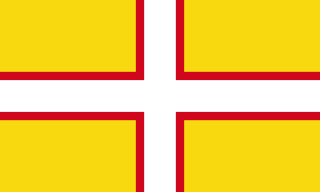
Dorset is a county in South West England on the English Channel coast. The ceremonial county comprises the unitary authority areas of Bournemouth, Christchurch and Poole and Dorset. Covering an area of 2,653 square kilometres (1,024 sq mi), Dorset borders Devon to the west, Somerset to the north-west, Wiltshire to the north-east, and Hampshire to the east. The county town is Dorchester, in the south. After the reorganisation of local government in 1974, the county border was extended eastward to incorporate the Hampshire towns of Bournemouth and Christchurch. Around half of the population lives in the South East Dorset conurbation, while the rest of the county is largely rural with a low population density.

Corfe Castle is a village and civil parish in the English county of Dorset. It is the site of a ruined castle of the same name. The village and castle stand over a gap in the Purbeck Hills on the route between Wareham and Swanage. The village lies in the gap below the castle and is around four miles (6.4 km) south-east of Wareham, and four miles (6.4 km) north-northwest of Swanage. Both the main A351 road from Lytchett Minster to Swanage and the Swanage Railway thread their way through the gap and the village.

Lyme Regis is a town in west Dorset, England, 25 miles (40 km) west of Dorchester and east of Exeter. Sometimes dubbed the "Pearl of Dorset", it lies by the English Channel at the Dorset–Devon border. It has noted fossils in cliffs and beaches on the Heritage or Jurassic Coast, a World Heritage Site. The harbour wall, known as The Cobb, appears in Jane Austen's novel Persuasion, the John Fowles novel The French Lieutenant's Woman and the 1981 film of that name, partly shot in the town. A former mayor and MP was Admiral Sir George Somers, who founded the English colonial settlement of Somers Isles, now Bermuda, where Lyme Regis is twinned with St George's. In July 2015, Lyme Regis joined Jamestown, Virginia in a Historic Atlantic Triangle with St George's. The 2011 Census gave the urban area a population of 4,712, estimated at 4,805 in 2019.

The sieges of Taunton were a series of three blockades during the First English Civil War. The town of Taunton, in Somerset, was considered to be of strategic importance because it controlled the main road from Bristol to Devon and Cornwall. Robert Blake commanded the town's Parliamentarian defences during all three sieges, from September 1644 to July 1645.

The Isle of Purbeck is a peninsula in Dorset, England. It is bordered by water on three sides: the English Channel to the south and east, where steep cliffs fall to the sea; and by the marshy lands of the River Frome and Poole Harbour to the north. Its western boundary is less well defined, with some medieval sources placing it at Flower's Barrow above Worbarrow Bay. John Hutchins, author of The History and Antiquities of the County of Dorset, defined Purbeck's western boundary as the Luckford Lake steam, which runs south from the Frome. According to writer and broadcaster Ralph Wightman, Purbeck "is only an island if you accept the barren heaths between Arish Mell and Wareham as cutting off this corner of Dorset as effectively as the sea." The most southerly point is St Alban's Head.

Charmouth is a village and civil parish in west Dorset, England. The village is situated on the mouth of the River Char, around 1+1⁄2 miles (2 km) north-east of Lyme Regis. Dorset County Council estimated that in 2013 the population of the civil parish was 1,310. In the 2011 Census the population of the parish, combined with the small parish of Catherston Leweston to the north, was 1,352.

The Device Forts, also known as Henrician castles and blockhouses, were a series of artillery fortifications built to defend the coast of England and Wales by Henry VIII. Traditionally, the Crown had left coastal defences in the hands of local lords and communities but the threat of French and Spanish invasion led the King to issue an order, called a "device", for a major programme of work between 1539 and 1547. The fortifications ranged from large stone castles positioned to protect the Downs anchorage in Kent, to small blockhouses overlooking the entrance to Milford Haven in Pembrokeshire, and earthwork bulwarks along the Essex coast. Some forts operated independently, others were designed to be mutually reinforcing. The Device programme was hugely expensive, costing a total of £376,000 ; much of this was raised from the proceeds of the Dissolution of the Monasteries a few years before.

Portland Castle is an artillery fort constructed by Henry VIII on the Isle of Portland, Dorset, between 1539 and 1541. It formed part of the King's Device programme to protect against invasion from France and the Holy Roman Empire, and defended the Portland Roads anchorage. The fan-shaped castle was built from Portland stone, with a curved central tower and a gun battery, flanked by two angular wings. Shortly after its construction it was armed with eleven artillery pieces, intended for use against enemy shipping, operating in partnership with its sister castle of Sandsfoot on the other side of the anchorage. During the English Civil War, Portland was taken by the Royalist supporters of King Charles I, and then survived two sieges before finally surrendering to Parliament in 1646.

Sandsfoot Castle, also known historically as Weymouth Castle, is an artillery fort constructed by Henry VIII near Weymouth, Dorset. It formed part of the King's Device programme to protect against invasion from France and the Holy Roman Empire, and defended the Weymouth Bay anchorage. The stone castle had an octagonal gun platform, linked to a residential blockhouse, and was completed by 1542 at a cost of £3,887. Earthwork defences were built around the landward side of the castle, probably in 1623. Sandsfoot saw service during the English Civil War, when it was held by Parliament and Royalists in turn during the conflict. It survived the interregnum but, following Charles II's restoration to the throne, the fortress was withdrawn from military use in 1665.

Chideock is a village and civil parish in south west Dorset, England, situated close to the English Channel between Bridport and Lyme Regis. Dorset County Council's 2013 estimate of the parish population is 550.

Dorset is a rural county in south west England. Its archaeology documents much of the history of southern England.

The Battle of Weymouth and the associated Crabchurch Conspiracy occurred in 1645, during the First English Civil War, when several royalist plotters within the twin towns of Weymouth and Melcombe on the Dorset coast conspired to deliver the ports back into the control of King Charles I.

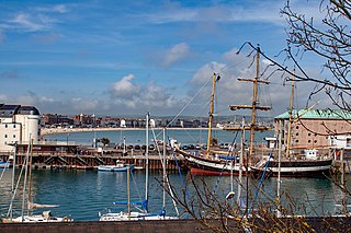
Weymouth is a seaside town in Dorset, on the English Channel coast of England. Situated on a sheltered bay at the mouth of the River Wey, 11 kilometres (7 mi) south of the county town of Dorchester, Weymouth had a population of 53,427 in 2021. It is the third largest settlement in Dorset after Bournemouth and Poole.

Corfe Castle is a fortification standing above the village of the same name on the Isle of Purbeck peninsula in the English county of Dorset. Built by William the Conqueror, the castle dates to the 11th century and commands a gap in the Purbeck Hills on the route between Wareham and Swanage. The first phase was one of the earliest castles in England to be built at least partly using stone when the majority were built with earth and timber. Corfe Castle underwent major structural changes in the 12th and 13th centuries.
Dorset is a county in South West England on the English Channel coast. The ceremonial county comprises the area covered by the non-metropolitan county, which is governed by Dorset Council, together with the unitary authorities of Poole and Bournemouth. Dorset is an average sized county with an area of 2,653 square kilometres (1,024 sq mi); it borders Devon to the west, Somerset to the north-west, Wiltshire to the north-east, and Hampshire to the east. Around half of Dorset's population lives in the South East Dorset conurbation. The rest of the county is largely rural with a low population density.
Robert Culliford was an English landowner and politician who sat in the House of Commons from 1660 to 1679.
The siege of Lyme Regis was an eight-week blockade during the First English Civil War. The port of Lyme Regis, in Dorset, was considered to be of strategic importance because of its position along the main shipping route between Bristol and the English Channel. Thomas Ceeley and Robert Blake commanded the town's Parliamentarian defences during the siege, which was laid by Prince Maurice between 20 April and 16 June 1644.