Highcliffe

Last updated

Highcliffe
Beach at Highcliffe - geograph.org.uk - 477841.jpg
Beach at Highcliffe
Dorset UK location map.svg
Red pog.svg
Highcliffe
Location within Dorset
Population3,673  [1]
OS grid reference SZ214936
Civil parish
Unitary authority
Ceremonial county
Region
Country England
Sovereign state United Kingdom
Post town CHRISTCHURCH
Postcode district BH23
Dialling code 01425
Police Dorset
Fire Dorset and Wiltshire
Ambulance South Western
UK Parliament
List of places
UK
England
Dorset
50°44′29″N1°41′45″W / 50.7414°N 1.6959°W / 50.7414; -1.6959

Highcliffe or Highcliffe-on-Sea is a seaside town in the civil parish of Highcliffe and Walkford, in the unitary authority area of Bournemouth, Christchurch and Poole, in the ceremonial county of Dorset in England. It forms part of the South East Dorset conurbation along the English Channel coast. The town lies on a picturesque stretch of Solent coastline with views of the Isle of Wight and its 'Needles' rocks. It is part of the historic county of Hampshire. [2] From 1974 to 2019 it was in the Christchurch district.

Contents

Location

Highcliffe is situated to the east of the historic town of Christchurch and the resort town of Bournemouth, and to the west of Barton on Sea and New Milton. The New Forest National Park is to the north.

Its position on the south coast gives it a climate with milder winters than inland areas, and less rainfall than locations further west. This helped establish the town as a popular health and leisure resort during the late Victorian and early Edwardian eras.

History

Highcliffe Castle Highcliffe Castle 4.jpg
Highcliffe Castle

What is now regarded as Highcliffe has developed over the last several hundred years from the hamlet of Slop Pond, the Chewton Estate, and Chewton Common. The latter two also contained large farmsteads.

Slop Pond was a collection of thatched cottages, named from the large pond on its common. The cottages were said[ by whom? ] to be occupied by farm workers and fishermen, who engaged in the smuggling and poaching trade now notorious in local history.

When the area became a more popular tourist destination in the Victorian era, Slop Pond was renamed Newtown. This was changed to Highcliff after the first house built on the high cliff, soon to become known as Highcliffe-on-Sea.

Between 1831 and 1835, Lord Stuart de Rothesay built Highcliffe Castle, a Gothic Revival home, near the site of High Cliff House, his father's Georgian estate. The design, by William Donthorne, a founder member of RIBA, incorporated large quantities of carved Medieval stonework salvaged from the Norman Benedictine Abbey of St Peter at Jumièges in northwest France and the Grande Maison des Andelys. At the beginning of the 20th century the reputation of Highcliffe was so considerable that in 1907 Kaiser Wilhelm II chose to stay at Highcliffe Castle when recuperating from the strain of political scandals in Germany. [3]

Highcliffe Castle is now a Grade I listed building described as "the most important remaining example of the Romantic and Picturesque style of architecture", and now holds events throughout the year open to the general public. It is also a popular venue for weddings and other private events. Harry Gordon Selfridge, founder of Selfridges & Co, rented the castle between 1916 and 1922. He is buried in a simple grave at St Marks Churchyard next to his wife and mother. The castle featured in Mr Selfridge, a TV series charting the life of the department store magnate.

Between 1911 and 1914 Greystones house was built in the village to a design by Edward Schroeder Prior. [4]

The area also has a strong literary connection and was once a centre for Wicca with Gerald Gardner and Dorothy Clutterbuck living in Highcliffe. Captain Frederick Marryat, author of The Children of The New Forest , was a regular visitor to the house on the Chewton estate (now the Chewton Glen Hotel, Spa and Country Club); and the adventure story author Colonel R.W. Campbell, veteran of the Boer and Great wars, was also a local resident.

Modern times

Highcliffe town centre in 2006 Lymington Road, Highcliffe - geograph.org.uk - 251216.jpg
Highcliffe town centre in 2006

Educational establishments in the town include Highcliffe St Mark Primary School and Highcliffe School. There are also independent preparatory and secondary schools local to the area in New Milton and Barton on Sea.

The Maritime and Coastguard Agency's national training centre was formerly located at Steamer Point.

Highcliffe Food and Arts Festival has taken place annually in June since 2014. It is run on a not-for-profit basis, and showcases local food, drinks and arts. It began as an offshoot of the nearby Christchurch Food Festival.

Politics

Highcliffe is part of the Christchurch parliamentary constituency for elections to the House of Commons. It is currently represented by Conservative MP Christopher Chope. Highcliffe is also part of the Highcliffe and Walkford and Mudeford, Stanpit and West Highcliffe wards for elections to Bournemouth, Christchurch and Poole Council.

Highcliffe was formerly a chapelry in the parish of Christchurch, [2] on 1 October 1897 Highcliffe became a separate civil parish, on 1 April 1932 the parish was abolished and merged with Christchurch. [5] In 1931 the parish had a population of 1738. [6]

Related Research Articles

<span class="mw-page-title-main">Christchurch, Dorset</span> Town and civil parish in England

Christchurch is a town and civil parish on the south coast of Dorset, England. The parish had a population of 31,372 in 2021. It adjoins Bournemouth to the west, with the New Forest to the east. Part of the historic county of Hampshire, Christchurch was a borough within the administrative county of Dorset from 1974 until 2019, when it became part of the new Bournemouth, Christchurch and Poole unitary authority.

<span class="mw-page-title-main">Chine</span> Steep-sided river valley

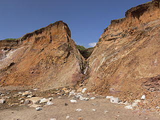
A chine is a steep-sided coastal gorge where a river flows to the sea through, typically, soft eroding cliffs of sandstone or clays. The word is still in use in central Southern England—notably in East Devon, Dorset, Hampshire and the Isle of Wight—to describe such topographical features. The term 'bunny' is sometimes used to describe a chine in Hampshire. The term chine is also used in some Vancouver suburbs in Canada to describe similar features.

<span class="mw-page-title-main">Ferndown</span> Human settlement in England

Ferndown is a town and civil parish in Dorset in southern England, immediately to the north of Bournemouth and Poole. The parish, which until 1972 was called Hampreston, includes the communities of Hampreston, Longham, Stapehill and Trickett's Cross. At the 2011 Census, the population of the parish was 26,559, making Ferndown the largest inland town in Dorset in terms of population, being larger than Dorchester.

<span class="mw-page-title-main">Milford on Sea</span> Human settlement in England

Milford on Sea, often hyphenated, is a large coastal village and civil parish in the New Forest district, on the Hampshire coast, England. The parish had a population of 4,660 at the 2011 census and is centred about 3 miles (4.8 km) south of Lymington. Tourism and businesses for quite prosperous retirees as well as the care sector make up large parts of its economy. Businesses include restaurants, cafés, tea rooms, small shops, garden centres, pubs and camping/lodge/caravan parks, bed-and-breakfasts and a few luxury hotels. Shops cluster on its small high street, which fronts a village green. The western cliffs are accessed by flights of steps. In common with the flatter coast by the more commercial and eastern part of Milford, they have car parks with some facilities, which, along with many apartment blocks and houses, have close views of The Needles, which are the main, large chalk rocks immediately next to the Isle of Wight.

<span class="mw-page-title-main">Branksome, Dorset</span> Human settlement in England

Branksome is a suburb of Poole, in the Bournemouth, Christchurch and Poole district, in the ceremonial county of Dorset, England. The area consists of residential properties and also a number of commercial and industrial areas.

<span class="mw-page-title-main">Kinson</span> Suburb of Bournemouth, England

Kinson is a former village which has been absorbed by the town of Bournemouth in the county of Dorset in England. The area became part of Bournemouth on 1 April 1931. There were two electoral wards containing the name Kinson. Their joint population at the 2011 Census was 19,824.

<span class="mw-page-title-main">Holdenhurst</span> Human settlement in England

Holdenhurst is a small isolated village situated in the green belt land of the north-east suburbs of Bournemouth, England. The village comprises fewer than 30 dwellings, two farms and the parish church. There are no shops and few local facilities in the village.

<span class="mw-page-title-main">Canford Magna</span> Village in Dorset, England

Canford Magna is a village in the Bournemouth, Christchurch and Poole district, in the ceremonial county of Dorset, England. The village is situated just south of the River Stour and lies between the towns of Wimborne Minster and Poole. The village has a mixture of thatch and brick buildings, mostly serving as residences for teaching staff. The western edge of the village merges with the residential suburb of Merley and the village community of Oakley.

<span class="mw-page-title-main">Highcliffe Castle</span> 19th century castle in Highcliffe, Dorset, England

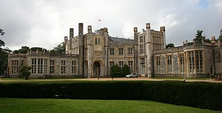
Highcliffe Castle, situated on the cliffs at Highcliffe, Dorset, was built between 1831 and 1835 by Charles Stuart, 1st Baron Stuart de Rothesay in a Romantic and Picturesque, Gothic Revival style near the site of High Cliff House, a Georgian Mansion designed for the 3rd Earl of Bute with the gardens laid out by Capability Brown. The design, by William Donthorne, a founder member of RIBA, incorporated large quantities of carved Medieval stonework salvaged from the ruined Benedictine Abbey of St Peter at Jumieges and the Grand' Maison des Andelys, both situated in Normandy, France. An historic Grade I listed building, it is now owned by the Christchurch, Dorset Council.

Stanpit is a neighbourhood in the Bournemouth, Christchurch and Poole unitary authority in the ceremonial county of Dorset, England. Stanpit is within Mudeford parish, and is situated on the shore of Christchurch Harbour, 1 mile (1.6 km) east of Christchurch town centre. Traditionally it is part of the historic county of Hampshire, and was a small village until the growth of the South East Dorset conurbation in the 20th century. The Stanpit road connects from the end of the original Mudeford road through to Purewell Cross.

<span class="mw-page-title-main">Listed buildings in Christchurch, Dorset</span>

Christchurch is a town and former borough in the county of Dorset on the English Channel coast, adjoining Bournemouth in the west, with the New Forest to the east. Historically in Hampshire, it joined Dorset with the reorganisation of local government in 1974 and is the most easterly borough in the county. Its close proximity to the Cotentin Peninsula made it an important trading port and a potential target for invasion during the Napoleonic and Second World Wars.

<span class="mw-page-title-main">Somerford, Dorset</span> Human settlement in England

Somerford is a district in the unitary authority of Bournemouth, Christchurch and Poole. It lies in the historic county of Dorset. It borders with Mudeford and is intersected by the Somerford Road (B3059). On the north side is an area of residential housing, originally developed as a council estate in the 1950s. The district has three schools: Somerford Infants, Somerford Junior and The Grange School. The present day biggest employer is BAE Systems. Historically, the biggest employers were Airspeed, de Havilland and Gardner's.

<span class="mw-page-title-main">2019 Bournemouth, Christchurch and Poole Council election</span> 2019 local election in Bournemouth, Christchurch and Poole

The 2019 Bournemouth, Christchurch and Poole Council election took place on 2 May 2019 to elect the inaugural members of Bournemouth, Christchurch and Poole Council in England, formed from the former unitary authorities of Bournemouth and Poole, and borough of Christchurch. At the same time an election for the new Christchurch Town Council was held.

The Christchurch Independents (CI) are a political party and group in the Bournemouth, Christchurch and Poole (BCP) Council, formed by journalist Andy Martin and (former) Conservative and Independent Councillors after the reorganisation of local government in Dorset, with new candidates joining to stand in Christchurch wards for the inaugural 2019 Bournemouth, Christchurch and Poole Council Election. Originally not forming a registered political party, CI was initially the joint-third largest alongside the Poole People and ALL group. In 2020, Christchurch Independents councillor Colin Bungey died, leading to a by-election being held the next year in the Commons Ward, for which the Christchurch Independents were registered as a political party.

<span class="mw-page-title-main">Walkford</span> Electoral division in Christchurch, England

Walkford is a settlement in the civil parish of Highcliffe and Walkford in Dorset in England. It is a suburb of the seaside town of Highcliffe, and part of the unitary authority of Bournemouth, Christchurch and Poole. Although Walkford is in the ceremonial county of Dorset, historically it was in Hampshire.

<span class="mw-page-title-main">Friars Cliff</span>

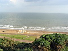
Friars Cliff is a neighborhood and beach in Christchurch, Dorset. It is east of Mudeford and west of Highcliffe.

<span class="mw-page-title-main">Highcliffe and Walkford (ward)</span> Electoral ward in Christchurch, Dorset, England

Highcliffe and Walkford is a ward in Christchurch, Dorset. Since 2019, the ward has elected 2 councillors to Bournemouth, Christchurch and Poole Council.

References

  1. "Ward-level population estimates (Experimental Statistics)". Office for National Statistics. Retrieved 30 July 2020.
  2. 1 2 "GB Historical GIS / University of Portsmouth, History of Highcliffe, in Christchurch and Hampshire | Map and description, A Vision of Britain through Time". Vision of Britain. Retrieved 12 December 2020.
  3. John C. G Röhl, 'Wilhelm II: Into the Abyss of War and Exile, 1900-1941', 2013; Western Gazette, Friday 22 November 1907, page 12.
  4. O’Brien, Charles; Bailey, Bruce; Pevsner, Nikolaus; Lloyd, David W. (2018). The Buildings of England Hampshire: South. Yale University Press. p. 343. ISBN   9780300225037.
  5. "Relationships and changes Highcliffe CP/PA through time". A Vision of Britain through Time . Retrieved 16 April 2024.
  6. "Population statistics Highcliffe CP/PA through time". A Vision of Britain through Time. Retrieved 16 April 2024.