Stanpit

Last updated • 9 min readFrom Wikipedia, The Free Encyclopedia

Stanpit
Dorset UK location map.svg
Red pog.svg
Stanpit
Location within Dorset
OS grid reference SZ1792
Unitary authority
Ceremonial county
Region
Country England
Sovereign state United Kingdom
Post town CHRISTCHURCH
Postcode district BH23
Dialling code 01202
Police Dorset
Fire Dorset and Wiltshire
Ambulance South Western
UK Parliament
List of places
UK
England
Dorset
50°43′N1°46′W / 50.72°N 1.76°W / 50.72; -1.76

Stanpit is a neighbourhood of Christchurch in the Bournemouth, Christchurch and Poole unitary authority in the ceremonial county of Dorset, England. Stanpit is within Mudeford parish, and is situated on the shore of Christchurch Harbour, 1 mile (1.6 km) east of Christchurch town centre. Traditionally it is part of the historic county of Hampshire, and was a small village until the growth of the South East Dorset conurbation in the 20th century. The Stanpit road connects from the end of the original Mudeford road through to Purewell Cross.

Contents

Stanpit is mentioned in the Domesday Book (1086) as Stanpeta meaning 2 estates with meadows. [1] On Isaac Taylor's 1759 map of Hampshire it is marked as Stampit. [2]

During the 19th-century, the area became known for smuggling and the nearby fishing village of Mudeford was the scene of the so-called 'Battle of Mudeford', a violent conflict between smugglers and revenue men that resulted in the death of a naval officer. The local Scout hut, situated on Stanpit recreation ground is named Orestes after the Royal Navy cutter which took part. [3] The recreation ground is also the site of an annual bonfire and firework event, commemorating the gunpowder plot. It takes place on or around 5 November and includes competitions and refreshments with the proceeds benefitting local youth organisations. [4]

History

Stanpit was named in the Domesday Book of 1086, in the Edgegate Hundred. [5]

Stanpit Marsh

The area known as Stanpit Marsh is a mixture of habitats including areas of salt marsh, reed beds, freshwater marsh, gravel estuarine banks and sandy scrub. [6] It was formed as the result of action and deposition of material from the rivers Stour and Avon as they meet with the salt water within Christchurch Harbour. Together with contiguous Grimbury (or sometimes Grimmery) Marsh, it forms one of the largest areas of salt marsh in the county. [7] Stanpit Marsh is a Site of Special Scientific Interest (SSSI) and an important nature reserve of about 65 hectares (160 acres), combining both freshwater and saltwater habitats. There are over 300 species of plants growing there and 14 of them are considered to be nationally rare and endangered. [6] It is used by 312 species of bird, a few of which breed there. Many others are migratory and use the marsh as an important staging point. In 2001 a successful breeding program for Natterjack Toads was established. [6] The site is owned by Christchurch Borough Council and managed by Christchurch Countryside Service.

The name of Grimbury Marsh can be traced back to the 13th century, where it appears as Greneburgh in the Christchurch Priory cartulary. [8] This name can be translated as 'green fort' and may be a reference to Crouch Hill, the highest point on the marsh, which has also been known as Grimbury Hill. [9]

Crouch Hill is a grass covered dune or Bronze Age burial mound. It stands 5 metres above sea level. In 1921-22 the mound was excavated by Harold St George Gray. Because of the amount of 19th century material recovered, he was convinced that it was of modern origin, despite the quantity of prehistoric material also found. In 1969 an excavation by Michael Ridley recovered flints, Neolithic Grooved Ware, and an almost complete Bronze Age inverted collared urn containing the cremated remains of a child. [10] In 1987, Dr Thomas C Welsh identified possible ancient earthworks in the vicinity, including another mound, named Druid's Mound, that had also been excavated by Gray. [11]

To the east of Crouch hill lies Blackberry Point. In the past this was a small island within the Harbour known locally as Horseshoe Island. Today it has become firmly attached to the marsh. [7]

Bailey bridge over Mother Sillars Channel at Stanpit Marsh Christchurch, Stanpit Marsh - geograph.org.uk - 1705320.jpg
Bailey bridge over Mother Sillars Channel at Stanpit Marsh

A circular path on the marsh crosses Mother Siller's Channel by way of a Bailey bridge of the sort developed in Christchurch. [12] In 1984 the original prototype Bailey bridge was replaced by the present bridge, which was donated by the local Royal Armament Research and Development Establishment (RARDE). Mother Siller's Channel is named after an 18th-century smuggler, Hannah Seller, the landlady of the Haven House at Mudeford and also reputedly of the Ship in Distress at Stanpit. It is thought that this channel, now silted up, used to lead to the back of the Ship in Distress and thus was a convenient and secretive 'trade' route. [13]

On the west side of the marsh the path goes past a stranded rusting hull, now fenced off for safety. Known locally as the Iron Boat, this was formerly the lifeboat of a WW2 Liberty ship. Its origin remains uncertain, but it was seemingly acquired in the 1950s by a boating club at the local Portchester School for boys (now Avonbourne Boys' Academy). It subsequently changed hands and is believed to have been deposited on the marsh by a severe storm in 1964. [14]

Formation and development

The marsh is geologically relatively new, the oldest parts date back about 10,000 years. Ever since the formation of the harbour, when the lower valleys of the rivers Avon and Stour were flooded by a post-glacial rise in sea level; the two rivers have been depositing their sediment in the shallow waters. During periods of low tide, channels and creeks began to appear and the isolated banks of silt became colonised by plants such as Glassworts, Sea Purslane and Seablite all of which have a high tolerance to salt water. These plants caused the flow of water to decrease further and thus more sediment was deposited. Eventually the mud banks grew above the high tide level and other vegetation was able to develop. [7]

The marsh is continuing to change and evolve. Separated from the older Stanpit Marsh by the Mother Siller's Channel is the more recent Grimbury marsh and to the south-east, the even more recent addition of Blackberry Island. Parts of the marsh have been drained and now provide grazing land for ponies.

The Marsh has a history of human activity dating back to 5000 BC. Excavations in 1969 on the eastern bank of Mother Siller's Channel revealed finds left by Mesolithic nomadic people (3000 BC). As well as flint fragments, traces of Purbeck Limestone and Portland stone were discovered showing evidence of human movements across Dorset. There have been considerable rises in the sea level over during the marshes existence. Finds up to the early Bronze Age were also made during these excavations. After the Iron Age material evidence of human activities is rare. [1]

The area was designated as a Local Nature Reserve in 1964 and a Site of Special Scientific Interest in 1986.

The Ship in Distress public house

The Ship in Distress Ship in Distress Stanpit Christchurch.JPG
The Ship in Distress

The Ship in Distress public house is located at the top of Mothers Sillars Channel, along the Stanpit road. It was the landlady of the pub, Hannah Seller, who the channel is named after. She had been married to the landlord of the Haven House on Mudeford Quay, and on his death, she took over the inn, later moving to The Ship in Distress. It appears that she was deeply involved in the free-trade: she allowed both pubs to be used for storage and would induce customers to assist smuggling vessels in difficulties. [15]

Next door to the pub was a tobacco and snuff factory, owned by the by then 'respectable' John Streeter who had earlier been gaoled for his part in the battle. Perhaps not unsurprisingly, many of the deliveries came at night and other local tobacco traders complained that they were unable to compete with Streeter. [13]

Tutton's Well

Tutton's Well is a small publicly accessible grassy space on the west of Stanpit road a short distance south of the Ship in Distress public house. On the site is a fresh water spring that is reputed to be of great antiquity and have special healing properties, especially for improving eyesight. In 1884 it was reported that it was "mentioned in ancient documents as a mineral well, and is supposed to possess properties highly beneficial to persons afflicted with weak eyes. The water is even now frequently carried away to different parts of the country for eye bathing". [16] The following year, eminent Bournemouth based physician Horace Dobell similarly wrote that "one spring at Stanpit has a mediæval fame as a good water and curative agent (monkish specific for blindness). It is a soft, shallow, wayside well". [17]

According to an anonymous letter printed in the local Christchurch Times newspaper in 1868, the name of the site dates to the Civil War period. The story claims that Oliver Cromwell and his attendants were one day riding past after reconnoitring the area. Being a hot day, Cromwell wanted to water his horse, so asked an old man if the patch of muddy water nearby was drinkable. The man said that it was too brackish, but directed him to a pool of fresh water, from which both Cromwell and his horse drank. The name of the old man was George Touting. [18] However, although some Parliamentarian activity did take place in the area, there is no evidence that Cromwell himself was ever present. The place-name suffix –ton is often derive from an Anglo-Saxon term for an enclosure or farmstead, which suggests that the name may have a far earlier origin.

In 1885 the Well was informally granted to the local inhabitants as a public water supply by the landowner, Sir William Rose, with the wish that it should commemorate his late parents, the Rt. Hon. Sir George Henry Rose and Dame Frances, of Sandhills, Mudeford. [19] It was subsequently acquired by the council. [20] The spring continued to supply the local residents with fresh water into the 20th century, even after all other public pumps and wells were closed in 1899. [21] Nevertheless, it soon began to fall into disrepair.

In 1996, concerns about the rebuilding of a Guides' hut on the site prompted the creation of a Tutton's Well Preservation Society to preserve, retain, enhance and restore the historical features of the site. In 2002 this became the Friends of Tutton's Well. [22] Archaeological investigations at the centre of the plot found a rubble-filled shaft that was constantly refilled with fresh water and tests confirmed the relative purity of the water. [23] The group subsequently erected stone features on the site to commemorate its long history. [24]

Politics

Stanpit is part of the Christchurch parliamentary constituency for elections to the House of Commons. It is currently represented by Conservative MP Christopher Chope.

Mudeford is also part of the Mudeford, Stanpit and West Highcliffe wards for elections to Bournemouth, Christchurch and Poole Council.

Related Research Articles

<span class="mw-page-title-main">River Avon, Hampshire</span> River in the south of England

The River Avon is in the south of England, rising in Wiltshire, flowing through that county's city of Salisbury and then west Hampshire, before reaching the English Channel through Christchurch Harbour in the Bournemouth, Christchurch and Poole conurbation of Dorset.

<span class="mw-page-title-main">Christchurch, Dorset</span> Town and civil parish in England

Christchurch is a town and civil parish on the south coast of Dorset, England. The parish had a population of 31,372 in 2021. It adjoins Bournemouth to the west, with the New Forest to the east. Part of the historic county of Hampshire, Christchurch was a borough within the administrative county of Dorset from 1974 until 2019, when it became part of the new Bournemouth, Christchurch and Poole unitary authority.

<span class="mw-page-title-main">Poole</span> Coastal town in Dorset, England

Poole is a coastal town and seaport on the south coast of England in the Bournemouth, Christchurch and Poole unitary authority area in Dorset, England. The town is 21 miles (34 km) east of Dorchester and adjoins Bournemouth to the east. Since 1 April 2019, the local authority is Bournemouth, Christchurch and Poole Council. The town had an estimated population of 151,500 making it the second-largest town in the ceremonial county of Dorset. Together with Bournemouth and Christchurch, the conurbation has a total population of nearly 400,000.

<span class="mw-page-title-main">Wytch Farm</span> Oil field and processing site in Dorset, England

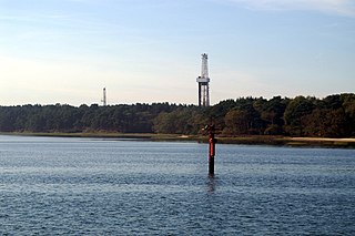
Wytch Farm is an oil field and processing facility in the Purbeck district of Dorset, England. It is the largest onshore oil field in Western Europe. The facility, taken over by Perenco in 2011, was previously operated by BP. It is located in a coniferous forest on Wytch Heath on the southern shore of Poole Harbour, two miles (3.2 km) north of Corfe Castle. Oil and natural gas (methane) are both exported by pipeline; liquefied petroleum gas is exported by road tanker.

<span class="mw-page-title-main">History of Dorset</span> History of the English county

Dorset is a rural county in south west England. Its archaeology documents much of the history of southern England.

<span class="mw-page-title-main">History of Hampshire</span> History of the English county

Hampshire is a county in Southern England with some notable archaeology and many notable historic buildings.

<span class="mw-page-title-main">Milford on Sea</span> Village and parish in Hampshire, England

Milford on Sea, often hyphenated, is a large coastal village and civil parish in the New Forest district, on the Hampshire coast, England. The parish had a population of 4,660 at the 2011 census and is centred about 3 miles (4.8 km) south of Lymington. Tourism and businesses for quite prosperous retirees as well as the care sector make up large parts of its economy. Businesses include restaurants, cafés, tea rooms, small shops, garden centres, pubs and camping/lodge/caravan parks, bed-and-breakfasts and a few luxury hotels. Shops cluster on its small high street, which fronts a village green. The western cliffs are accessed by flights of steps. In common with the flatter coast by the more commercial and eastern part of Milford, they have car parks with some facilities, which, along with many apartment blocks and houses, have close views of The Needles, which are the main, large chalk rocks immediately next to the Isle of Wight.

<span class="mw-page-title-main">Hengistbury Head</span> Headland and archeological site in Dorset

Hengistbury Head, formerly also called Christchurch Head, is a headland jutting into the English Channel between Bournemouth and Mudeford in the English county of Dorset. It is a site of international importance in terms of its archaeology and is scheduled as an Ancient Monument. Declared a Local Nature Reserve in 1990, the head and its surroundings form part of the Christchurch Harbour Site of Special Scientific Interest. It is also a Special Area of Conservation, Special Protection Area, an Environmentally Sensitive Area and a Site of Nature Conservation Interest. The name "Hengistbury Head" refers to the whole of the headland area; the elevated portion is called Warren Hill.

<span class="mw-page-title-main">Poole Bay</span> Bay in Poole, United Kingdom

Poole Bay is a bay in the English Channel, on the coast of Dorset in southern England, which stretches 16 km from Sandbanks at the mouth of Poole Harbour in the west, to Hengistbury Head in the east. Poole Bay is a relatively shallow embayment and consists of steep sandstone cliffs and several 'chines' that allow easy access to the sandy beaches below. The coast along the bay is continuously built up, and is part of the South East Dorset conurbation, including parts of the towns of Poole, Bournemouth and Christchurch.

<span class="mw-page-title-main">Highcliffe</span> Human settlement in England

Highcliffe or Highcliffe-on-Sea is a seaside town in the civil parish of Highcliffe and Walkford, in the unitary authority area of Bournemouth, Christchurch and Poole, in the ceremonial county of Dorset in England. It forms part of the South East Dorset conurbation along the English Channel coast. The town lies on a picturesque stretch of Solent coastline with views of the Isle of Wight and its 'Needles' rocks. It is part of the historic county of Hampshire. From 1974 to 2019 it was in the Christchurch district.

<span class="mw-page-title-main">Christchurch Harbour</span> Human settlement in England

Christchurch Harbour is a natural harbour in the county of Dorset, on the south coast of England named after the nearby town of Christchurch. Two rivers, the Avon and the Stour, flow into the Harbour at its northwest corner. The harbour is generally shallow and due to the tidal harmonics in the English Channel has a double high water on each tide. On the north side of the harbour, east of the Avon are Priory Marsh, and to the east of this Stanpit Marsh, a Local Nature Reserve. To the west side of the harbour are Wick Fields, the southern flank of the harbour being bounded by Hengistbury Head, a prominent coastal headland. The harbour flows into the Christchurch Bay and the English Channel through a narrow channel known locally as The Run which rests between Mudeford Quay and Mudeford Spit. Shallow-draught boats can enter from this channel and cruise up stream for 2 miles (3 km) choosing either the Avon or the Stour, the Stour leading up as far as Iford Bridge passing Christchurch Quay and Tuckton.

<span class="mw-page-title-main">Kinson</span> Suburb of Bournemouth, England

Kinson is a former village which has been absorbed by the town of Bournemouth, in the Bournemouth, Christchurch and Poole district, in the ceremonial county of Dorset, England. The area became part of Bournemouth on 1 April 1931. There were two electoral wards containing the name Kinson. Their joint population at the 2011 census was 19,824.

<span class="mw-page-title-main">Lewis Tregonwell</span>

Lewis Dymoke Grosvenor Tregonwell was a captain in the Dorset Yeomanry and a historic figure in the early development of what is now Bournemouth.

Mudeford is a harbourside and beachside parish based on a former fishing village in the east of Christchurch, Dorset, England, fronting water on two sides: Christchurch Harbour and the sands of Avon Beach.

The Battle of Mudeford was a skirmish fought between smugglers and Customs and Excise officers which occurred in 1784 on what is now a car park at Mudeford Quay, Mudeford, Christchurch, England near the entrance of Christchurch Harbour. The battle showed how widespread smuggling was at the time and resulted in the death of a Customs officer and subsequent trial and execution of one of the smugglers.

<span class="mw-page-title-main">Listed buildings in Christchurch, Dorset</span>

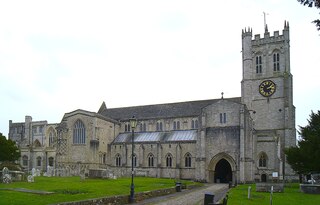
Christchurch is a town and former borough in the county of Dorset on the English Channel coast, adjoining Bournemouth in the west, with the New Forest to the east. Historically in Hampshire, it joined Dorset with the reorganisation of local government in 1974 and is the most easterly borough in the county. Its close proximity to the Cotentin Peninsula made it an important trading port and a potential target for invasion during the Napoleonic and Second World Wars.

<span class="mw-page-title-main">History of Christchurch, Dorset</span>

Christchurch is a town, civil parish and former borough in the county of Dorset on the English Channel coast, adjoining Bournemouth in the west, with the New Forest to the east. Historically in Hampshire, it joined Dorset with the reorganisation of local government in 1974 and is the most easterly borough in the county. The town has existed since 650 AD and its close proximity to the Cotentin Peninsula made it an important trading port and a potential target for invasion during the Napoleonic and Second World Wars.

<span class="mw-page-title-main">Somerford, Dorset</span> Human settlement in England

Somerford is a district of Christchurch in the Bournemouth, Christchurch and Poole district of Dorset, England. It borders with Mudeford and is intersected by the Somerford Road (B3059). On the north side is an area of residential housing, originally developed as a council estate in the 1950s. The district has three schools: Somerford Infants, Somerford Junior and The Grange School. The present day biggest employer is BAE Systems. Historically, the biggest employers were Airspeed, de Havilland and Gardner's.

<span class="mw-page-title-main">Bournemouth, Christchurch and Poole</span> Unitary authority area in Dorset, England

Bournemouth, Christchurch and Poole (BCP) is a unitary authority area in the ceremonial county of Dorset, England. The district was created on 1 April 2019 by the merger of the areas that were previously administered by the unitary authorities of Bournemouth and Poole, and the non-metropolitan district of Christchurch. The authority covers much of the area of the South Dorset conurbation.

<span class="mw-page-title-main">Hoburne Park</span> Area of Christchurch, Dorset, England

Hoburne Park is an area of Christchurch, Dorset.

References

  1. 1 2 "Stanpit Marsh". Hengistbury-head.co.uk. Archived from the original on 6 October 2011. Retrieved 7 May 2011.
  2. Section 22, Map of Hampshire (1759) Isaac Taylor
  3. "Stanpit Marsh". Dorset for You. Retrieved 2 January 2017.
  4. "Stanpit Fireworks". Christchurch Rotary Club. 3 October 2016. Retrieved 2 January 2017.
  5. "Stanpit | Domesday Book". opendomesday.org. Retrieved 30 October 2024.
  6. 1 2 3 Dorset for You web page on Stanpit Marsh
  7. 1 2 3 Chaffey, John (2004). The Dorset Landscape, Its Scenery and Geology. Halsgrove House, Tiverton.: Dorset Books. p. 49. ISBN   1-871164-43-5.
  8. Hanna, Katharine (2007). The Christchurch Priory Cartulary. The Castle, Winchester, SO23 8UJ: Hampshire County Council. pp. 442, 451–452. ISBN   978-1-85975-761-1.{{cite book}}: CS1 maint: location (link)
  9. "Petty Sessions". Hampshire Advertiser. 6 November 1869. p. 7.
  10. "Historic England Research Records: Crouch Hill". Heritage Gateway. Retrieved 31 March 2021.
  11. Welsh, Thomas. "The Invisible Site-finder" (PDF). Librarylink Highland. p. 14. Retrieved 31 March 2021.
  12. "Archived copy". Archived from the original on 6 October 2011. Retrieved 7 May 2011.{{cite web}}: CS1 maint: archived copy as title (link)
  13. 1 2 Stannard, Michael (1999). The Makers of Christchurch: A Thousand Year story. Natula Publications. pp. 177–178. ISBN   978-1-897887-22-6.
  14. Llewellyn, Nigel (November 2012). "The Boat on the Marsh". The Journal of the Christchurch History Society. 30: 12–13.
  15. Smuggling Gazetteer
  16. "Tuton's Well". Salisbury and Winchester Journal. 20 September 1884. p. 6.
  17. Horace Dobell (1885). The Medical Aspects of Bournemouth and Its Surroundings. Smith, Elder. p. 2. Retrieved 31 March 2021.
  18. "Correspondence". Christchurch Times. 25 July 1868. p. 8.
  19. "A Proposed Recreation Ground at Stanpit". Christchurch Times. 19 March 1887. p. 5.
  20. "Town Council Meeting". Christchurch Times. 24 November 1888. p. 4.
  21. "The Medical Officer's Report". Christchurch Times. 19 May 1900. p. 5..
  22. "Friends of Tutton's Well Constitution". Tutton’s Well. Retrieved 5 April 2021.
  23. "Water Quality Report". Tutton’s Well. Retrieved 5 April 2021.
  24. "Open Day". Tutton’s Well. Retrieved 5 April 2021.