
Dorset is a ceremonial county in South West England. It is bordered by Somerset to the north-west, Wiltshire to the north and the north-east, Hampshire to the east, the Isle of Wight across the Solent to the south-east, the English Channel to the south, and Devon to the west. The largest settlement is Bournemouth, and the county town is Dorchester.

Bournemouth is a coastal resort town in the Bournemouth, Christchurch and Poole unitary authority area, in the ceremonial county of Dorset, England. The 2021 census built-up area had a population of 196,455, making it the largest town in Dorset.
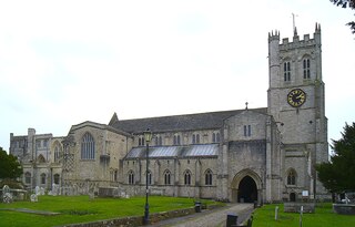
Christchurch is a town and civil parish on the south coast of Dorset, England. The parish had a population of 31,372 in 2021. It adjoins Bournemouth to the west, with the New Forest to the east. Part of the historic county of Hampshire, Christchurch was a borough within the administrative county of Dorset from 1974 until 2019, when it became part of the new Bournemouth, Christchurch and Poole unitary authority.
New Forest is a local government district in Hampshire, England. Its council is based in Lyndhurst, although the largest town is Totton. The district also includes the towns of Fordingbridge, Lymington, New Milton and Ringwood. The district is named after and covers most of the New Forest National Park, which occupies much of the central part of the district. The main urban areas are around the periphery of the forest. The district has a coastline onto the Solent to the south and Southampton Water to the east.

Arne is a village and civil parish in Dorset, England, situated 4 miles (6.4 km) east of Wareham. The local travel links are located at Wareham railway station. Bournemouth International Airport is 11 miles (18 km) away. The main road through the village is Arne Road connecting Arne to Wareham. The village is situated on the Arne Peninsula, which protrudes into Poole Harbour opposite the town of Poole.

Christchurch railway station serves the town of Christchurch in Dorset, England. The station is a stop on the South West Main Line between London Waterloo and Weymouth. It is located 104 miles 28 chains (167.9 km) down the line from Waterloo, with services currently operated by South Western Railway

Highcliffe or Highcliffe-on-Sea is a seaside town in the civil parish of Highcliffe and Walkford, in the unitary authority area of Bournemouth, Christchurch and Poole, in the ceremonial county of Dorset in England. It forms part of the South East Dorset conurbation along the English Channel coast. The town lies on a picturesque stretch of Solent coastline with views of the Isle of Wight and its 'Needles' rocks. It is part of the historic county of Hampshire. From 1974 to 2019 it was in the Christchurch district.

Holdenhurst is a village in the civil parish of Throop and Holdenhurst, in the Bournemouth, Christchurch and Poole district, in Dorset, England, situated in the green belt land of the north-east suburbs of Bournemouth. The village comprises fewer than 30 dwellings, two farms and the parish church. There are no shops and few local facilities in the village.

Dorset County Council (DCC) was the county council for the county of Dorset in England. It provided the upper tier of local government, below which were district councils, and town and parish councils. The county council had 46 elected councillors and was based at County Hall in Dorchester. The council was abolished on 31 March 2019 as part of structural changes to local government in Dorset.

Bournemouth Borough Council was the local authority of Bournemouth in Dorset, England and ceased to exist on 1 April 2019. It was a unitary authority, although between 1974 and 1997 it was an administrative district council with Dorset. Previously most of the borough was part of Hampshire.
Throop is a village in the civil parish of Throop and Holdenhurst, in the Bournemouth, Christchurch and Poole district, in Dorset, England, situated on the outskirts of Bournemouth. It is renowned for its expansive fishing industry.
Avon Lodge was a private untimetabled railway station in the county of Hampshire, opened on 13 November 1862 by the Ringwood, Christchurch and Bournemouth Railway. Becoming part of the London and South Western Railway, it was taken into the Southern Railway in the grouping of 1923 and closed on 30 September 1935.

Hurn was a railway station in the county of Hampshire, opened on 13 November 1862 by the Ringwood, Christchurch and Bournemouth Railway. Becoming part of the London and South Western Railway, it was taken into the Southern Railway in the grouping of 1923 and closed on 30 September 1935.
The Ringwood, Christchurch and Bournemouth Railway was a railway company formed to link Christchurch and Bournemouth, England, to the London and South Western Railway's Southampton and Dorchester line at Ringwood. The RC&BR opened in 1862 from Christchurch to Ringwood, and was extended to Bournemouth in 1870, sharing in the growing popularity of the town. However the route was circuitous, and the London and South Western Railway opened a shorter route between Brockenhurst and Christchurch via Sway in 1888, making the Ringwood to Christchurch section a branch line.
Burton is a village in the civil parish of Burton and Winkton in the Bournemouth, Christchurch and Poole district of Dorset, England. The village is elevated above the Avon Valley on a gravel plateau. Much of the village was built in the 1970s, and today the population is around 4,000.

Bournemouth, Christchurch and Poole (BCP) is a unitary authority area in the ceremonial county of Dorset, England. The district was created on 1 April 2019 by the merger of the areas that were previously administered by the unitary authorities of Bournemouth and Poole, and the non-metropolitan district of Christchurch. The authority covers much of the area of the South Dorset conurbation.

Winkton is a hamlet in the historic county of Hampshire and the ceremonial county of Dorset, England. Together with the village of Burton, it is part of the civil parish of Burton and Winkton, in the district of Bournemouth, Christchurch and Poole.

Commons is a ward of Christchurch, Dorset. Since 2019, the ward has elected 2 councillors to Bournemouth, Christchurch and Poole Council.

Hurn Court in Hurn near Christchurch, Dorset, was the home of the Earls of Malmesbury between 1795 and 1951. It was sold on the death of the 5th Earl and opened as a boarding school for boys in 1952, before being developed for housing in the 1990s. It has been a Grade II* Listed building since 1964.

St Leonards and St Ives is a civil parish in Dorset, England. The parish contains the settlements of Ashley, Ashley Heath, St Ives and St Leonards, which have merged to form a single urban area.

