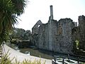
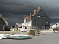
Five of the town's grade I listed structures. In the foreground, the mediaeval town and mews bridges; in the centre, the 12th-century Constable's House; in the background to the right, the Norman castle, and to the left, the Priory church.
The borough has over 300 nationally listed buildings and structures, a sample of which are described below, and more than 200 locally listed.[3]:13[4][5][6]
In England, a building or structure is defined as "listed" when it is placed on a statutory register of buildings of "special architectural or historic interest" by the Secretary of State for Culture, Media and Sport, a Government department, in accordance with the Planning (Listed Buildings and Conservation Areas) Act 1990.[7]English Heritage, a non-departmental public body, acts as an agency of this department to administer the process and advise the department on relevant issues.[8] There are three grades of listing status: Grade I, defined as being of "exceptional interest"; Grade II*, "particularly important buildings of more than special interest"; and Grade II, used for buildings of "special interest".[9]
Christchurch has seven structures of Grade I status, 12 listed at Grade II* and 316 of Grade II status.[4][5] Three of the Grade I structures are bridges, one a church, one a Gothic mansion, one a Norman dwelling and one a Norman castle.[4]:1–5 Other structures given recognition by English Heritage include a Victorian pillar box, a 1935 telephone kiosk, a bandstand, a mausoleum (see below), a drinking fountain (see below), two entire graveyards, and two war memorials.[5]
Christchurch town centre and the Harbour are overlooked by the 11th-century Christchurch Priory. Once a monastery, it was given to the town for use as a parish church by Henry VIII after the dissolution in 1540.[10]:141 It is the longest parish church in England with a nave over 311 feet long.[11]:87 The nave and transepts are Norman with heavy columns and round arches, whereas the lady chapel is from the 14th century and more 'Perpendicular' in style. The great choir is even later, having been rebuilt in the 16th century. The Priory is famous for its Miraculous Beam, which attracts pilgrims from all over the world.[11]:87 DoE Reference: 748/1/14[4]:4
The castle ruins are of a motte and bailey construction and are of Norman origin or possibly even Saxon. It has been suggested that there may have been a castle on this spot as early as 924 AD when; after Aethelwold captured the town ramparts in 901 AD, Edward the Elder decided to fortify the town further with a wooden fort on a motte.[11]:87 After the Norman Conquest (1066) the castle's defences were again strengthened with the addition of a ditch and bailey surrounded by a wooden palisade. The wooden fort was replaced; at first with another wooden structure and then in 1300, with a stone keep.[11]:89 Today the bailey is home to a bowling green and gardens, and the ditch has been filled but parts of the keep and the constable's house still stand. DoE Reference: 1A/17[4]:2
The Constable's House is a domestic Norman dwelling which was built within the original castle bailey in 1160, earlier than the existing stone keep. Much of the stonework survives, including a rare example of a Norman Chimney (one of only five in the country). The ground floor which has four slit windows was used as a storeroom. The upper floor accessed by steps outside and an internal staircase contained the main hall. As well as the chimney, another notable feature is the privy which extends out over the mill stream.[12] DoE Reference: 1A/18[4]:3
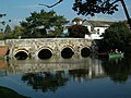
This 15th-century ashlar bridge is sometimes referred to as Quartley's Bridge after Dr. Quartley whose house sits on a narrow strip of land between the Little Avon and the millstream. Dr. Quartley is associated with the town's smuggling folklore. The bridge crosses the narrower of the two branches of the Avon on what was, before the bypass was constructed, the only easterly route out of the town and the only crossing point below Sopley. It has five low, round headed arches with cutwaters between and parapet above. DoE Reference: 1A/19[4]:1
Listed as the western part of the Town Bridge but separated by a narrow strip of land, this bridge is one of two mediaeval bridges that cross the mill stream. Built at the same time as the Town Bridge from the same materials, it has two 2 arches with a cutwater between and parapets. It has no documented name but is often referred to as the Mews bridge or sometimes also as Quartley's bridge. DoE Reference: 1A/19[4]:1
Waterloo Bridge crosses the wider of the two branches of the Avon on the same easterly route out of the town as the Town Bridge. Built circa 1816 but in the mediaeval tradition from dressed stone, with wide segmental arches, circular piers and capped cutwaters. DoE Reference: 1A/20[4]:1
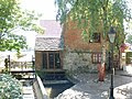
Place Mill is an Anglo-Saxon watermill mentioned in the Domesday Book.[14] The mill stopped working in 1908 and stood derelict until it was restored in 1981. "It is remarkable, in that it takes water from one river and spills it into a second river".[10]:4 A mill-stream is supplied from the River Avon, near to the Electricity Museum behind Bargates, and flows for nearly half a mile to the mill between the Avon and the Priory grounds, before joining the River Stour at the Town Quay. DoE Reference: 1A/15[5]:111[15]
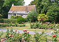
The second of the town's museums is The Red House Museum built in 1764 as the town workhouse. Many of the women and children that worked in the towns' fusee factories came from here.[10]:220,224 It contains a variety of exhibitions pertaining to local history, costume, geology, natural history and archaeology. In addition there are a number of temporary exhibitions that change every few weeks. The grounds contain both formal and informal gardens. DoE Reference: 1A/11.[5]:113[16] The boundary walls are grade II listed.[5]:111
Church Hatch is a red brick, Georgian house in Church Street. It was the home of Major-General Sir Owen Tudor Burne, renowned soldier and 3 times private secretary to the Viceroy of India. It was saved from demolition in 1929 by public appeal. DoE Reference: 1A/7[5]:43[17]:18 Another former resident was the taphephobic Mrs Perkins whose grade II listed mausoleum can be found in Priory Gardens at the rear of the property.[5]:47[18] The railings, gate and walls are also grade II* listed.[5]:45
Standing on the edge of Quay Road but within the priory grounds, is Priory Cottage. Mediaeval in origin, it was built as a porter's lodge and apart from the Priory itself; is the only monastic building to have survived the dissolution. It was restored by the last prior in the 16th century. DoE Reference: 1A/12[5]:112
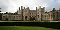
Tyneham House is a two-storey, 18th-century stuccoed building with brick eaves and cornice. The house has a centre portion of three windows and advanced side wings with hipped roofs. The Doric porch in the centre has a three-light sash window to each side. There is a stone triglyph frieze and cornice over these windows and the door. It is supposed that the name of the house is a misspelling of the town's ancient name of Twynham, although there is a village of the same name in Dorset. DoE Reference: 1A/29[5]:11
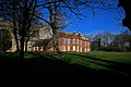
Burton Hall was built around 1750 as a 3-storey, private residence but has since been converted into flats. It is a fine example of a grand house from the period and has a stylish facade constructed from brick but with stone dressings. The centre breaks slightly forward and has pediment. Plain parapet and modillion cornice, rusticated quoins and brick stacks. Above the doorway is a pedimented window with a stone balustrade below and flanked by smaller windows. The centre, second-floor window has moulded stone architrave. There is a former orangery at the north end with 5 round arched windows. The interior still retains it large staircase, moulded architrave, six-panelled doors and 18th-century fireplaces. DoE Reference: 9/364[5]:132
Built in the early 19th century, this two-storey residence and shop front has a painted brick facade with eaves, cornice and slate roof. Two of the five windows on the first floor are bricked (as a way of avoiding paying the 1766 window tax), dating the building to pre 1851. The shop front on the ground floor has two bowed shop windows with glazing bars, flanking a centre double doorway with a wide, flat cornice overall. There is an additional round arched doorway with a fanlight to east of shop. DoE Reference: 1A/28[5]:20
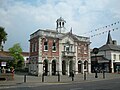
The Mayor's Parlour. Was originally built as the market hall in 1745 at the junction of Castle Street, Church Street and the High Street; it was moved to its present position in 1849. Later it was enclosed and extended, and used as the town hall until the civic offices were built, in Bridge Street, in the mid-1970s. It was partly demolished and restored to its former condition circa 1982 when Saxon Square was built. The Celtic cross in the square marks the back of the building before its demolition. DoE Reference: 1A/98[1]:13,17,23,24[5]:53
Built on the site of an earlier Congregational church which dated from 1660, this church in Millhams Street was built in 1866 to a Kemp-Welch and Pinder design. Constructed from buff brick with stone dressings and a roof of patterned, two tone slates; the sizable church and attached Sunday school buildings are mainly Gothic in appearance but with a mixture of Romanesque and Cinquecento detail. The tall, slender, steeple has a splayed pyramid spire with a weather vane finial. Below this is a clock, then recessed belfry with triple round-arched windows, 3 portholes with 'quasi-tiled' roof of stone to cornice, a two light Cinquecento window and a round-arched doorway. The west front has a double arched entrance in a low gabled porch constructed from pink stone with colonnettes, foliage capitals and vermiculated keystones. Above is a 4-light round-arched window with tracery of roundels (1 cusped) and Lombard frieze to gable. The 2 storey side elevations have lower windows with shouldered flat-arched lights under segmental relieving arch and foliage tympanum. The upper windows are 2-light Cinquecento style under cross gables. The attached Sunday schools have a similar elevation and roof. It is now a United Reformed Church. DoE Reference: 1A/56.[5]:81 The associated graveyards on either side of the street are also grade II listed. DoE Reference: 1A/57
The Ship Inn which has the oldest licence in Christchurch, was a known haunt of smugglers. There is a smugglers' cache on the roof between the pub and the old toll house next door (now a 'phone shop) which is only visible from an alleyway opposite.[1]:19 The facade is 19th-century but the building is much older. The Ship's history can be traced back to 1688. DoE Reference: 1A/95[5]:54[17]:53
Ye Olde George Inne is one of two listed public houses in the town centre. Originally called the George and Dragon, it was a coach house where the Emerald coach would stop on its way from Lymington to Poole. The old timber framed building was refaced with brick in the early 18th century, and some of the glazing dates back to the 19th century. DoE Reference: 1A/5[1]:17[5]:31
The Perfumery is a 14th-century thatched property which is often referred to, and indeed listed as the old courthouse; although many local historians (including Michael A. Hodges and Sue Newman) maintain that this was next door and long gone. Nevertheless, as it is owned by the council, it can lay claim to being the oldest council house in the borough.[1]:31[11]:90 The late mediaeval timber frame was refaced in both the 18th and 19th centuries. The first floor is jettied out and the gable end has elaborate, carved, bargeboards and beams. DoE Reference: 1A/24[5]:32
Built within the Priory grounds, in 1777 by Gustavus Brander, a curator at the British Museum and a governor of the Bank of England. It is here that the future King of France (Prince Louis Phillipe) took refuge during the Napoleonic Wars.[1]:9 Brander is also known for his work with native fossils and for producing the first book on them.[1]:9 DoE Reference: 1A/13[5]:112
This mediaeval bridge crosses the mill stream just before Place Mill, an Anglo-Saxon watermill on the Town Quay. Officially it has no name but is often referred to as the Place Mill Bridge. The oldest part of the bridge, the arches, date back to Saxon times. DoE Reference: 1A/16. Further upstream, by the town, is another mediaeval bridge which has a grade I listing.[5]:107
Ye Olde Eight Bells is now a gift shop but once was another alehouse frequented by smugglers and central to a number of local legends. A date above the door suggests that the building dates back to 1450 AD. It was here that a young woman foiled a revenue search by sitting with a tub of brandy beneath her skirts, while she nursed a baby. It was also reported that there was a tunnel from the basement leading to the Ship in Distress at Stanpit, over a mile away.[19] The name comes from the Priory peal which at the time was seven bells (it is now twelve) and thus was a joke along the same lines of the nineteenth hole on a golf course. It closed as a public house in 1907.[1]:12 Listed as No.16 Church Street. DoE Reference: 1A/8[5]:49
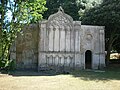
A fear of being buried alive led the owner of this mausoleum to request that her body not be interred, nor her coffin lid screwed down, and that it should be placed at the entrance to the priory's school so that the pupils would hear if she revived. When her husband died 20 years later in 1803, her body was removed, the structure sold, and re-erected in Priory Gardens.[20] DoE Reference: 1A/152[5]:47
Built in 1903 to power the town's trams, the power station in Bargates is one of the most complete, early power stations to have survived in England. It was constructed in the late Victorian Italianate style from red brick with stone and terracotta dressings.[5]:3 Now a Museum of Electricity, it houses a variety of educational exhibits and old machinery, including a tram.[11]:82–83 It is one of two museums in the town. DoE ref 491644
The old Fusee factory in Bargates.[5]:5 Was built in 1845 to an advanced design with particularly large windows on either side. 74 feet long but only 18 feet wide, it allowed the maximum amount of natural light to enter for the intricate assembly work that was carried out within.[10]:197[11]:82The two-storey building is constructed from red brick with grey headers and bears a slate roof. DoE ref 1/66 1A/66.[5]:5
Bemister's fountain is a grade II listed drinking fountain and cattle trough erected to commemorate Samuel Bemister, a local businessman and mayor of Christchurch no less than 7 times. Constructed entirely of pink granite, the cattle trough sits on stone end blocks with heart-shaped niches in each. Below there are 3 smaller troughs for cats and dogs hollowed out from plinth. A short round column with a drinking fountain rises at one end from square base. This column is reminiscent of the town's power station chimney. It is this power station that Bemister supplied with coal brought from Southampton in his fleet of windjammers to the town quay. Built circa 1900 at the end of High St., it was moved to the quay when the bypass was built. It can now be found at the south end of Bargates close to its original site, now occupied by the Fountain Roundabout.[21] 1A/441[5]:1
Listed as No.15 (Midland Bank), as it then was, the HSBC bank in the High Street is an Edwardian Baroque building in white stone with a balustraded parapet to a roof which isn't visible from ground level. The rounded south eastern corner terminates in a dome, the base of which has low relief carving. It has 3 round arched windows on a plinth which are separated by engaged Tuscan pillars. The entrance below the dome has a draped blank plaque with swags above door and the doorway has dentil cornice, segmental canopy and stone architrave. DoE ref 1A/75.[5]:56
The Kings Arms Hotel is a building in two parts. The western section was built in the 18th century as Humby's, on the site of a 17th-century inn of the same name.[17]:19 It housed the South Hants Militia until the barracks were built in 1794.[1]:30 This section, in painted brick, has a steeply pitched, slate roof with moulded eaves and cornice. Some of the sash windows have boxed frames and 19th-century glazing. The eastern section was built around 1800 with a brick facade with stucco plinth and a hipped bellcast slate roof, again with moulded wood eaves cornice. In the centre of the first floor are 3 lights with a stone pediment above, and with flanking pilasters. An iron balcony extends along the width of the first floor. The wide porch below has Tuscan columns and the door is flanked by narrow lights with a wide fanlight above. DoE ref 1A/26.[5]:30
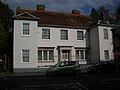
Quartley's is an early-19th-century, 3-storey, private residence with a slate roof with red ridge tiles and dormer. The restored, stucco facade has 5 sash windows with glazing bars and a 6-panelled double door with panelled reveals and a flat canopy on brackets. It is approached by a flight of railed steps and has iron area railings along the street boundary. DoE ref 1A/154.[5]:27
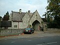
Designed by renowned architect Benjamin Ferrey, this 19th-century lodge at Jumpers' Cemetery is built in the form of a gatehouse from stone with ashlar dressings. The arched, off centre, gabled entrance crosses the road into cemetery. It is of an asymmetrical design of 1 and 11⁄2 storeys with a tiled roof. The entrance has a ground floor window with relieving arch above and gabled dormer. DoE Reference: 4/224.[5]:66 Benjamin Ferrey was born and lived in the town.[22]
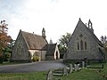
Another of Ferrey's designs, the two chapels at Jumpers' Cemetery form a group with the lodge. Built at the same time from stone with tiled roofs, they face each other across the roadway. Lacking towers, each has a bellcotte. Often referred to as the twin chapels, although similar, there are differences, as the accompanying picture demonstrates. DoE Reference: 4/243.[5]:66
Sandhills was the holiday home of Sir George Rose, Member of Parliament and close friend and advisor to the prime minister William Pitt. It was built on the beach at Mudeford and Sir George's other great friend, King George III stayed there on a number of occasions, helping to promote Christchurch as a tourist destination.[1]:116 Sandhills, Mudeford was also home to George Rose's two sons: Sir George Henry Rose, politician and diplomat, and William Rose, poet.[23]:52Field Marshal Hugh Rose, 1st Baron Strathnairn, GCB, GCSI, son of George Henry Rose also spent time living at the family home.[5]:91[23]:46,47 Sandhills is now a holiday park with static caravans in the grounds but the house still remains although it has been converted to flats. DoE Reference: 6/41
Gundimore is a house near Avon Beach built in 1796 for the poet William Rose. Visitors to the house included fellow poets Coleridge and Southey. Sir Walter Scott stayed there while writing his epic poem Marmion. The building is of the most unusual design, said to have been built in the shape of a Turkish tent, complete with gilt Arabic inscriptions to remind the original owner of his travels in the east. It consisted of a centre section and 2 wings. The centre section has 5 windows with a large curved centre bay with a shallow pitched, conical roof. At the south west corner of this bay is a round, 2 storey turret, shaped like a squat house with the upper storey almost completely glazed. The north eastern wing is now Scott's Cottage. Rose is believed to have designed at least part of the house himself.[24] DoE Reference: 3/42.[5]:84
The cottages on Mudeford Quay were originally built for workers involved with the dredging of the harbour and the Avon during the 17th century. Part of the group of cottages later became the Haven Inn, now known as the Dutch House which was the main focus in the Battle of Mudeford.[1]:110 The current Haven House tavern is an impostor dating back only a 150 years or so. DoE Reference: 6/43.[5]:95
No 12 Castle Street, Christchurch. DoE ref 1A/101 Grid Reference: SZ1596392731.[5]:25
No 18 Castle Street, Christchurch. DoE ref 1A/25 Grid Reference: SZ1597392769.[5]:26
No 20 Castle Street, Christchurch. DoE ref 1A/153 Grid Reference: SZ1603692747[5]:26
The railings at Quartley's, No22 Castle Street, Christchurch. DoE ref 1A/154 Grid Reference: SZ1604792750.[5]:27
Nos 14 & 16 Castle Street, Christchurch. DoE ref 1A/100 Grid Reference: SZ1596992735.[5]:27
Nos 2 & 4 Castle Street, Christchurch. DoE ref 1A/110 Grid Reference: SZ1593292730.[5]:28
Nos 6 & 6a Castle Street, Christchurch. DoE ref 1A/111 Grid Reference: SZ1594192731.[5]:29
No 1 Castle Street, Christchurch. DoE ref 1A/23 Grid Reference: SZ1593592702.[5]:31
No 3 Castle Street, Christchurch. DoE ref 1A/117 Grid Reference: SZ1594592700.[5]:33
No 5 Castle Street, Christchurch. DoE ref 1A/116 Grid Reference: SZ1595392701.[5]:33
No 7 Castle Street, Christchurch. DoE ref 1A/115 Grid Reference: SZ1596192703.[5]:34
No 9 Castle Street, Christchurch. DoE ref 1A/114 Grid Reference: SZ1596992700.[5]:34
Signboard of King's Arms Hotel, Castle Street, Christchurch. DoE ref 1A/113 Grid Reference: SZ1600192719.[5]:35
Yew Cottage, No 29 Chewton Common Road, Chewton Common, Highcliffe. DoE ref 14/442 Grid Reference: SZ2158994028.[5]:35
Heath Cottage, No 33 Chewton Common Road, Chewton Common, Highcliffe. DoE ref 13/416 Grid Reference: SZ2157293994.[5]:36
Little Megs, No 35 Chewton Common Road, Chewton Common, Highcliffe. DoE ref 13/418 Grid Reference: SZ2156494002.[5]:36
No 35a Chewton Common Road, Chewton Common, Highcliffe. DoE ref 13/419 Grid Reference: SZ2156494002.[5]:36
Little Thatch, No 39 Chewton Common Road, Chewton Common, Highcliffe. DoE ref 14/424 Grid Reference: SZ2145794032.[5]:37
The Cottage, No 45 Chewton Common Road, Chewton Common, Highcliffe. DoE ref 14/425 Grid Reference: SZ2140294034.[5]:37
No 1 Church Lane, Christchurch. DoE ref 1A/133 Grid Reference: SZ1585292582.[5]:38
Candlemas Cottage, No 12 Church Lane, Christchurch. Haunted. Two reports of reflections of fire being seen in windows of back upstairs room. Two reports of reflections of fire being seen in windows of back upstairs room. DoE ref 1A/127 Grid Reference: SZ1592192630.[5]:38
No 9 Church Lane, Christchurch. DoE ref 1A/130 Grid Reference: SZ1590592624.[5]:39
Nos 10 & 11 Church Lane, Christchurch. DoE ref 1A/129 Grid Reference: SZ1591392628.[5]:39
Nos 2 & 3 Church Lane, Christchurch. DoE ref 1A/131 Grid Reference: SZ1586692602.[5]:40
Nos 4, 6, 7 and 8 Church Lane, Christchurch. DoE ref 1A1/10 Grid Reference: SZ1589792615.[5]:40
No 1 Church Street, Christchurch. DoE ref 1A/118 Grid Reference: SZ1593592702.[5]:41
No 10 Church Street, Christchurch. DoE ref 1A/121 Grid Reference: SZ1596092639.[5]:42
No 11 Church Street, Christchurch. DoE ref 1A/122 Grid Reference: SZ1595492635.[5]:42
No 12 Church Street, Christchurch. DoE ref 1A/6 Grid Reference: SZ1596092639.[5]:43
No 2 Church Street, Christchurch. DoE ref 1A/119 Grid Reference: SZ1592992695.[5]:44
No 3 & 3a Church Street, Christchurch. DoE ref 1A/120 Grid Reference: SZ1593492691.[5]:44
Nos 14 & 16 (including wall lamp) Church Street, Christchurch. DoE ref 1A/8 Grid Reference: SZ1594892606.[5]:49
Nos 1 and 2 Quay Road, Christchurch. DoE Ref 1A/143 Grid Reference: SZ1588892591.[5]:109
Vicarage garden wall along Church Street, Quay Road, Christchurch. DoE Ref 1A/126 Grid Reference: SZ1596492599.[5]:110
The art gallery and picture store (originally the stables) at the Red House Museum, Quay Road, Christchurch. DoE Ref 1A/142 Grid Reference: SZ1588292570.[5]:110
The bandstand on the Quomps, Quay Road, Christchurch. DoE Ref 1A/148 Grid Reference: SZ1592892385[5]:111
The boundary wall to the Red House Museum, Quay Road, Christchurch. DoE Ref 1A/145 Grid Reference: SZ1588292570[5]:111
Pillar box (Edward VIII) outside Walkford sub post office, DoE Ref 14/440 Grid Reference: SZ2145894552[5]:113
No 144 Ringwood Road, Walkford, Highcliffe. DoE Ref 14/431 Grid Reference: SZ2128494649.[5]:114
Ivy Cottage, No 84 Ringwood Road, Walkford, Highcliffe. DoE Ref 14/429 Grid Reference: SZ2158694461.[5]:114
Cranemoor URC, No 142 Ringwood Road, Walkford, Highcliffe. DoE Ref 14/430 Grid Reference: SZ2128194634.[5]:114
The former Bosley farmhouse, 168 River Way, Christchurch. DoE Ref 8/334 Grid Reference: SZ1380095163.[5]:115
The Thatch, Roeshot Hill, Christchurch. DoE Ref 6/273 Grid Reference: SZ1921294486.[5]:115
The milestone outside the Roeshot public house, Roeshot Hill, Christchurch. DoE Ref 6/274 Grid Reference: SZ1875194122.[5]:115
No 61 Salisbury Road, Burton. DoE Ref 6/287 Grid Reference: SZ1679394398.[5]:116
Nos 110 to 114 Salisbury Road, Burton. DoE Ref 6/296 Grid Reference: SZ1672394784.[5]:116
↑ David Eels. "This is Dorset Communigate". Christchurch Castle. Christchurch Local History Society. Archived from the original on 15 May 2011. Retrieved 12 August 2010.
↑ Fraser Donachie. "This is Dorset Communigate". Benjamin Ferrey. Christchurch Local History Society. Archived from the original on 1 November 2010. Retrieved 12 August 2010.
1 2 Powell, Mike (1995). Christchurch Harbour. Briar Park Business Centre, Stour Rd, Christchurch: Natula Publications. ISBN1-897887-07-8.
This page is based on this Wikipedia article Text is available under the CC BY-SA 4.0 license; additional terms may apply. Images, videos and audio are available under their respective licenses.