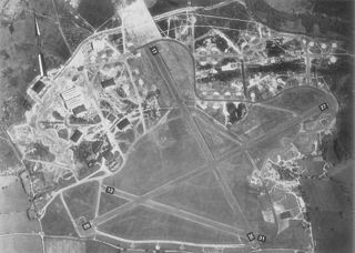
It was a civil airfield starting from 1926, then it was used during World War II by the Royal Air Force and the United States Army Air ForcesNinth Air Force. After the war the airfield returned to civilian use and the airfield complex was then demolished in 1966.
Before World War II
Flying at Christchurch started in July 1926, when Surrey Flying Services began offering five-shilling pleasure flights from an area known as "Burrysfield". In May 1928, the Hampshire Aero Club operated from the area. The next step was when Francis C. Fisher leased some open fields where he operated a flying facility in the summers until his lease ran out in 1932 by which time Fisher had flown over 19,000 passengers. In 1933, Sir Alan Cobham's Air Circus put on a show there attended by around 8,000 spectators.[1] In the same year, the Rambler Air Station was established and airline services commenced on 14 May 1934 with Western Airways operating a de Havilland Dragon Rapide and the airfield was known as Christchurch Airport. In February 1935, the airfield temporarily became known as Bournemouth Airport – not to be confused with nearby Bournemouth Airport at Hurn.[2]
In World War II, the airfield became RAF Christchurch. The Air Defence Research and Development Establishment was built at the northeastern end of the airfield, and in May 1940, the RAF Special Duties Flight, operating an assortment of aircraft arrived to take part in the experiments with radar. The Airspeed factory was also built on part of the original airfield and began production of Horsa Mk I gliders, AS.10 Oxfords, and de Havilland Mosquitos for the RAF.
In 1943, the USAAF Ninth Air Force required several temporary advanced landing grounds along the southern English Channel coast prior to the Normandy invasion to provide tactical air support for the ground forces landing in France. Christchurch was provided to support this mission.
After the USAAF departure the airfield was returned to RAF control. In March 1945, control passed to RAF Transport Command. The main activities continued to be production (Mosquitos) by Airspeed, radar trials and glider pick-up training. In January 1946, control of the airfield passed to the Ministry of Aircraft Production.
After World War II
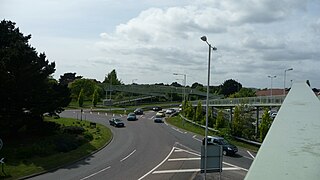
Airfield Way in Somerford – site of Christchurch Airfield
With the facility released from military control, civilian flying returned to Christchurch. The Christchurch Aero Club operated from the north side while on the southwestern tip of the field the RAF's 622 Gliding School operated for many years from a hangar just outside the airfield boundary.
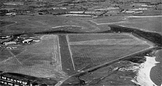
In 1954, the Military Experimental Engineering Establishment from Christchurch laid a Tarmac runway on the site of the World War II wire and PSP (pierced steel planking) runway. The main beneficiaries of this exercise was the De Havilland factory which was producing Vampire, Venom, Sea Venom and Sea Vixen jet fighters and the Airspeed Ambassador twin piston-engined airliners.[3]
Following the closure of De Havilland factory in 1962, the use of the airfield rapidly declined. The staffed air traffic control tower was closed in July 1963 and the Aero Club closed in 1964. The airfield officially closed at the end of 1964, although the occasional aircraft used the airfield until around 1974.
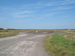
Today, the airfield site has been developed by the urban areas of Somerford/Mudeford. It is now a mix of housing and industry with nothing remaining of the airfield except some of the Airspeed buildings and streets named after aircraft.
Related Research Articles
Exeter Airport, formerly Exeter International Airport, is an international airport located at Clyst Honiton in East Devon, close to the city of Exeter and within the county of Devon, South West England. Exeter has a CAA Public Use Aerodrome Licence that allows flights for the public transport of passengers or for flying instruction. The airport offers both scheduled and holiday charter flights within Europe.
Royal Air Force Bovingdon or more simply RAF Bovingdon is a former Royal Air Force station located near the village of Bovingdon, Hertfordshire, England, about 2.5 miles (4.0 km) south-west of Hemel Hempstead and 2.5 miles (4.0 km) south-east of Berkhamsted.
Hawarden Airport, also known as Hawarden Aerodrome, is an airport near Hawarden in Flintshire, Wales, near the border with England and 3.5 NM west southwest of the city of Chester.
Royal Air Force Horsham St Faith or more simply RAF Horsham St Faith is a former Royal Air Force station near Norwich, Norfolk, England which was operational from 1939 to 1963. It was then developed as Norwich International Airport.
Sherburn-in-Elmet Airfield is located 1.5 nautical miles east of Sherburn in Elmet village and 5.5 NM west of Selby, North Yorkshire, England.
Royal Air Force Keevil or more simply RAF Keevil is a former Royal Air Force station, now controlled by the Army Air Corps. It lies between the villages of Keevil and Steeple Ashton, about 4 miles (6.4 km) east of the town of Trowbridge, in Wiltshire, England.
Royal Air Force Hurn or more simply RAF Hurn is a former Royal Air Force station located approximately 4 miles (6.4 km) north west of Christchurch, Dorset, England
Royal Air Force Thruxton or more simply RAF Thruxton is a former Royal Air Force station located 5 miles (8.0 km) west of Andover, Hampshire.
Royal Air Force Chilbolton or RAF Chilbolton is a former Royal Air Force station in Hampshire, England. The airfield was located in Chilbolton approximately 4 miles (6.4 km) south-southeast of Andover.
Royal Air Force Merryfield or more simply RAF Merryfield is a former Royal Air Force station in the village of Ilton near Ilminster in southwest Somerset, England. The airfield is located approximately 7 miles (11 km) north of Chard, about 130 miles (210 km) southwest of London. It is now RNAS Merryfield and serves as a satellite to the larger RNAS Yeovilton; it is used mainly as a training facility for helicopter pilots.
Samlesbury Aerodrome is a disused airfield at Balderstone near Samlesbury and Blackburn in the Ribble Valley district of Lancashire. The aerodrome is owned by defence company BAE Systems which uses the site for the manufacture of several different aircraft. Currently the company employs approximately 3,000 people at the site. The aerodrome is part of Lancashire Enterprise Zone.
Royal Air Force Tarrant Rushton or more simply RAF Tarrant Rushton is a former station of the Royal Air Force near the village of Tarrant Rushton east of Blandford Forum in Dorset, England from 1943 to 1947. It was used for glider operations during the Second World War and later revived for civilian operations. It is currently disused, though some buildings survive. Today it serves as a visual reference point (VRP) for VFR flights, in particular NW departures from Bournemouth Airport.
Royal Air Force Weston-super-Mare, or more simply RAF Weston-super-Mare, is a former Royal Air Force station which was located on a civilian airfield in Weston-super-Mare, Somerset, England.
Royal Air Force Pengam Moors, or more simply RAF Pengam Moors,, is a former Royal Air Force station and maintenance unit (MU), located on the Pengam Moors area of Tremorfa, situated 2 miles (3.2 km) south east of Cardiff city centre in Wales, from June 1938 to January 1946.
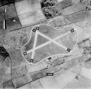
Royal Air Force Christchurch or more simply RAF Christchurch is a former Royal Air Force satellite station and was located southeast of the A337/B3059 junction in Somerford, Christchurch, Dorset, England.
Christchurch is a town, civil parish and former borough in the county of Dorset on the English Channel coast, adjoining Bournemouth in the west, with the New Forest to the east. Historically in Hampshire, it joined Dorset with the reorganisation of local government in 1974 and is the most easterly borough in the county. The town has existed since 650 AD and its close proximity to the Cotentin Peninsula made it an important trading port and a potential target for invasion during the Napoleonic and Second World Wars.
Lasham Airfield is an aerodrome 3.6 miles (5.8 km) north-west of Alton in Hampshire, England, in the village of Lasham.
Somerford is a district of Christchurch in the Bournemouth, Christchurch and Poole district of Dorset, England. It borders with Mudeford and is intersected by the Somerford Road (B3059). On the north side is an area of residential housing, originally developed as a council estate in the 1950s. The district has three schools: Somerford Infants, Somerford Junior and The Grange School. The present day biggest employer is BAE Systems. Historically, the biggest employers were Airspeed, de Havilland and Gardner's.
Dübendorf Military Airport was a military airfield of the Swiss Air Force northeast of Dübendorf in Switzerland, located east of Zürich. It includes the Flieger-Flab-Museum.
Martin Hearn Ltd. was a British aviation company which during World War II played a major role in the assembly of thousands of American and Canadian aircraft imported to Liverpool by shipping convoys.
References
↑ Stannard, Michael (1999). The Makers of Christchurch: A Thousand Year story. Natula Publications. pp.226–228. ISBN978-1-897887-22-6.
↑ White, Allen (1987) Christchurch Airfield – 40 Years of Flying
↑ Stannard, Michael (1999). The Makers of Christchurch: A Thousand Year story. Natula Publications. p.234. ISBN978-1-897887-22-6.
Phipp, Mike (2006) 'Bournemouth's Airports – A History' (Tempus Publishing, Stroud, Gloucs, ISBN0 7524 3923 5).
This page is based on this Wikipedia article Text is available under the CC BY-SA 4.0 license; additional terms may apply. Images, videos and audio are available under their respective licenses.