
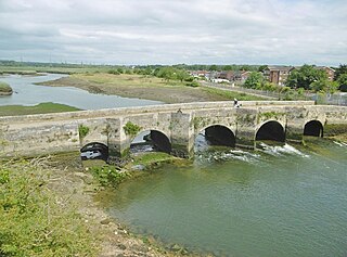
The River Avon is in the south of England, rising in Wiltshire, flowing through that county's city of Salisbury and then west Hampshire, before reaching the English Channel through Christchurch Harbour in the Bournemouth, Christchurch and Poole conurbation of Dorset.
Christchurch is a town and civil parish on the south coast of Dorset, England. The parish had a population of 31,372 in 2021. It adjoins Bournemouth to the west, with the New Forest to the east. Part of the historic county of Hampshire, Christchurch was a borough within the administrative county of Dorset from 1974 until 2019, when it became part of the new Bournemouth, Christchurch and Poole unitary authority.

Lymington is a port town on the west bank of the Lymington River on the Solent, in the New Forest district of Hampshire, England.

New Milton is a market town and civil parish in the New Forest district, in southwest Hampshire, England. To the north is in the New Forest and to the south the coast at Barton-on-Sea. The town is equidistant between Lymington and Christchurch, 6 miles (9.7 km) away. In 2011 it had a population of 19,969.
New Forest is a local government district in Hampshire, England. Its council is based in Lyndhurst, although the largest town is Totton. The district also includes the towns of Fordingbridge, Lymington, New Milton and Ringwood. The district is named after and covers most of the New Forest National Park, which occupies much of the central part of the district. The main urban areas are around the periphery of the forest. The district has a coastline onto the Solent to the south and Southampton Water to the east.

Burton on the Wolds is a village in Leicestershire, England situated on the B676 road 3 miles (4.8 km) west of the A46 and about the same distance to the east of Loughborough, close to the county border with Nottinghamshire. In the 2011 census, the population was measured at 1,218. The Parish Council of Burton on the Wolds, Cotes and Prestwold serves the village and its two neighbouring hamlets. The local borough council is Charnwood.

The Avon Valley Path is a long-distance path, opened in 1992, which runs for 34 miles through the English counties of Wiltshire, Hampshire and Dorset.

Hordle is a village and civil parish in the county of Hampshire, England. It is situated between the Solent coast and the New Forest, and is bordered by the towns of Lymington and New Milton. Like many New Forest parishes Hordle has no village centre. The civil parish includes the hamlets of Tiptoe and Everton as well as part of Downton. The parish was originally much larger; stretching from the New Forest boundary to Hurst Castle.

Sway is a village and civil parish in Hampshire in the New Forest national park in England. The civil parish was formed in 1879, when lands were taken from the extensive parish of Boldre. The village has shops and pubs, and a railway station on the South West Main Line from Weymouth and Bournemouth to Southampton and London Waterloo. It is the site of Sway Tower, a 66-metre (217 ft) concrete folly built in the 19th century. The outbuildings of the Grade II listed Forest Heath House are used as artist studios and exhibition space by the charity SPUDWorks.

Bashley is a chapelry in the New Forest in the south west of Hampshire, England. It takes up the north of New Milton civil parish of a type having a town council, and is a semi-rural community in New Forest District, to which it contributes about a quarter of the population of the ward of the same name. Bashley begins 2 miles (3 km) inland from the Solent. Most of its modest population is in its holiday park which has a chain-based convenience shop. Bashley has two garden centres, both football and cricket clubs, a few guesthouses, two riding schools/centres, a post office/store and a petrol station. Within the forest commons across cattle grids in its former hamlet of Wootton which has a large listed building pub-restaurant, once a drovers' retreat.

Wellow is a village and civil parish in Hampshire, England that falls within the Test Valley district. The village lies just outside the New Forest, across the main A36 road which runs from the M27 motorway to Salisbury. The nearest town is Romsey, 4 miles (6.4 km) to the east, and the closest city is Southampton, 9 miles (14 km) to the southeast. The parish had a population of 3,239 in the 2021 census.
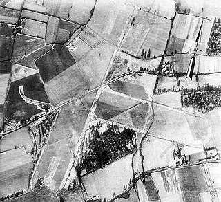
Royal Air Force Winkton, or more simply RAF Winkton, is a former Royal Air Force Advanced Landing Ground previously in Hampshire but now, due to County boundary changes, in Dorset, England. The airfield is located approximately 3 miles (4.8 km) north of Christchurch; and is named after the nearby hamlet of Winkton.
Burton is a small village and former civil parish, now in the parish of Duddon and Burton, in the unitary authority of Cheshire West and Chester and the ceremonial county of Cheshire, England. In the 2001 census, the parish had a population of 50.

Harbridge is a small village and former civil parish, now in the parish of Ellingham, Harbridge and Ibsley, in the New Forest district, in the county of Hampshire, England. It is located some four kilometres north of Ringwood and a similar distance south of Fordingbridge, in southwest Hampshire. In 1931 the parish had a population of 276.

Landford is a village and civil parish 10 miles (16 km) southeast of Salisbury in Wiltshire, England. To the south and east of the parish is the county of Hampshire and the New Forest National Park. The parish includes the small village of Nomansland and the hamlets of Hamptworth and Landfordwood.
Burton is a village in the civil parish of Burton and Winkton in the Bournemouth, Christchurch and Poole district of Dorset, England. The village is elevated above the Avon Valley on a gravel plateau. Much of the village was built in the 1970s, and today the population is around 4,000.

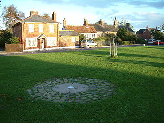
Sopley is a village and civil parish situated in the New Forest National Park of Hampshire, England. It lies on the old main road from Christchurch to Ringwood, on the east bank of the River Avon. The parish extends east as far as Thorny Hill and borders the parishes of Bransgore and Burton to the south and west respectively. It lies down the road from a small hamlet called Ripley. It includes the hamlets of Shirley, Avon and Ripley. The area is mainly rural with less than 300 dwellings.

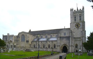
Christchurch is a town and former borough in the county of Dorset on the English Channel coast, adjoining Bournemouth in the west, with the New Forest to the east. Historically in Hampshire, it joined Dorset with the reorganisation of local government in 1974 and is the most easterly borough in the county. Its close proximity to the Cotentin Peninsula made it an important trading port and a potential target for invasion during the Napoleonic and Second World Wars.

Avon Tyrrell is an historic manor within the parish of Sopley, Hampshire. It is situated within the New Forest, near Christchurch. The present manor house was built in 1891 by John Manners-Sutton, 3rd Baron Manners (1852–1927).

Purewell is an area of Christchurch, Dorset.

