
Sarsen stones are silicified sandstone blocks found extensively across southern England on the Salisbury Plain and the Marlborough Downs in Wiltshire; in Kent; and in smaller quantities in Berkshire, Essex, Oxfordshire, Dorset, and Hampshire.
Sarsen stones are silicified sandstone blocks found extensively across southern England on the Salisbury Plain and the Marlborough Downs in Wiltshire; in Kent; and in smaller quantities in Berkshire, Essex, Oxfordshire, Dorset, and Hampshire.
Sarsen stones are the post-glacial [1] remains of a cap of Cenozoic silcrete that once covered much of southern England. This is thought to have formed during Neogene to Quaternary weathering by the silicification of Upper Paleocene Lambeth Group sediments, resulting from acid leaching. [2]
There are several potential sources for the word "sarsen."
The first is that the word "sarsen" is a shortening of "Saracen stone" which arose in the Wiltshire dialect. In the Middle Ages, "Saracen" was a common name for Muslims, and came by extension to be used for anything regarded as non-Christian, whether Muslim or pagan in contrast to Christianity. [3]
The second is that "sarsen" is a vernacular variation of the Indo-European "sasan," name given to the prehistoric vaults of the Chotanagpur plateau of Northern India. [4]
The third possibility is that "sarsen" comes from the hybrid Anglo-Saxon "sar-stan" or 'troublesome stone.' "Sar" has the meaning of 'grievous.' [4]
The builders of Stonehenge used these stones for the Heel Stone and sarsen circle uprights. [5] [6] Avebury and many other megalithic monuments in southern England are also built with sarsen stones. [7]
While sarsen stones are not an ideal building material, fire and in later times explosives were sometimes employed to break the stone into pieces of a suitable size for use in construction. William Stukeley wrote that sarsen is "always moist and dewy in winter which proves damp and unwholesome, and rots the furniture". [8] [9] In the case of Avebury, the investors who backed a scheme to recycle the stone were bankrupted when the houses they built proved to be unsaleable and also prone to burning down.[ citation needed ] However, despite these problems, sarsen remained highly prized for its durability, being a favoured material for steps and kerb stones.[ citation needed ]
![]() Media related to Sarsen stones at Wikimedia Commons
Media related to Sarsen stones at Wikimedia Commons
| Structure and surroundings | 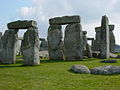 | |
|---|---|---|
| Replicas and derivatives | ||
| Studies | ||
| In culture | ||
| Concepts | ||