
The Amesbury Archer is an early Bronze Age man whose grave was discovered during excavations at the site of a new housing development in Amesbury near Stonehenge. The grave was uncovered in May 2002, and the man is believed to date from about 2300 BC. He is nicknamed "the Archer" because of the many arrowheads buried with him. The grave contained more artefacts than any other British Bronze Age burial, including the earliest known gold objects ever found in England.

Woodhenge is a Neolithic Class II henge and timber circle monument within the Stonehenge World Heritage Site in Wiltshire, England. It is 2 miles (3.2 km) north-east of Stonehenge, just north of the town of Amesbury.
Durrington Walls is the site of a large Neolithic settlement and later henge enclosure located in the Stonehenge World Heritage Site. It lies 2 miles (3.2 km) north-east of Stonehenge in the parish of Durrington, just north of Amesbury.
The Aubrey holes are a ring of fifty-six (56) chalk pits at Stonehenge, named after the seventeenth-century antiquarian John Aubrey. They date to the earliest phases of Stonehenge in the late fourth and early third millennium BC. Despite decades of argument and analysis, their purpose is still unknown although an astronomical role has often been suggested.

Bluestone is a cultural or commercial name for a number of dimension or building stone varieties, including:

The Sanctuary is a prehistoric site on Overton Hill located around 5 miles west of Marlborough in the English county of Wiltshire. Four concentric rings of post holes, and two outer rings of standing stones were first noted in 1648, and were drawn by William Stukeley in 1723, shortly before it was largely destroyed by a local farmer. Excavation in 1930 re-identified the location of the 58 stone sockets and 62 post-holes, the locations of which are now marked with concrete blocks.

Carn Menyn is a grouping of craggy rock outcrops or tors in the Preseli Hills in the Welsh county of Pembrokeshire.

The Altar Stone is a recumbent central megalith at Stonehenge in England, dating to Stonehenge phase 3i, around 2600 BC. It is made of a purplish-green micaceous sandstone and is thought to have originated from outcrops of the Senni Beds formation of the Old Red Sandstone in Wales, though this is currently in debate. Stone 80 was most recently excavated in the 1950s, but no written records of the excavation survive, and there are no samples available for examination that are established as having come from the monolith. Stone 55 lies on top of Stone 80 perpendicularly, and is thought to have fallen across it. The Altar Stone weighs approximately six tons and would have stood nearly two metres tall. Some believe that it always was recumbent It is sometimes classed as a bluestone, because it does not have a local provenance.
Records of archaeological excavations at the Stonehenge site date back to the early 17th century.

Stonehenge has been the subject of many theories about its origin, ranging from the academic worlds of archaeology to explanations from mythology and the paranormal.

Heelstone Ditch is a roughly circular feature surrounding the Heelstone at Stonehenge. It is not known if there was an intended relationship between the ditch and the heelstone although it is likely that the stone was in place either before or at the same time as the ditch. It has steep sloping sides which end at a narrow flat base, and is approximately 4 ft (1.2m) deep and 3.5 ft (1.1m) wide. It is some 12 ft (3.7m) from base the base of the Heelstone, with a diameter of roughly 32 ft (9.7m). A broad arcing trench found in 1923 by Lt-Col William Hawley 9 ft (2.7m) wide cuts this ditch from the West, deepening towards the stone. Against the Heelstone Ditch is rammed chalk filled Stonehole 97, whose missing stone is known as Heelstone's twin although it is possible that the stone in Stonehole 97 was moved and is now the stone known as the Heelstone. The ditch was probably dug after the stone in Stonehole 97 was moved but possibly before that.
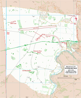
The Stonehenge Riverside Project was a major Arts and Humanities Research Council-funded archaeological research study of the development of the Stonehenge landscape in Neolithic and Bronze Age Britain. In particular, the project examined the relationship between the Stones and surrounding monuments and features including the River Avon, Durrington Walls, the Cursus, the Avenue, Woodhenge, burial mounds, and nearby standing stones. The project involved a substantial amount of fieldwork and ran from 2003 to 2009. It found that Stonehenge was built 500 years earlier than previously thought and was built to unify the peoples of Britain. It also found a new stone circle, Bluestonehenge.

Stonehenge in its landscape: Twentieth century excavations by Rosamund M. J. Cleal, Karen E. Walker and Rebecca Montague is an archaeological report on Stonehenge published in 1995. It presented the results of a two-year intensive study of all the known records of the various excavations at Stonehenge in the twentieth century, including a rephasing of the development of the monument.

The Y and Z Holes are two rings of concentric circuits of 30 and 29 near identical pits cut around the outside of the Sarsen Circle at Stonehenge. The current view is that both circuits are contemporary. Radiocarbon dating of antlers deliberately placed in hole Y 30 provided a date of around 1600 BCE, a slightly earlier date was determined for material retrieved from Z 29. These dates make the Y and Z holes the last known structural activity at Stonehenge.

Bluestonehenge or Bluehenge is a prehistoric henge and stone circle monument that was discovered by the Stonehenge Riverside Project about 1 mile (1.6 km) south-east of Stonehenge in Wiltshire, England. All that currently remains of the site is the ditch of the henge and a series of stone settings, none of which is visible above ground.
Timothy Darvill is an English archaeologist and author, best known for his publications on prehistoric Britain and his excavations in England, Wales, and the Isle of Man. He is Professor of Archaeology in the Faculty of Science and Technology Bournemouth University in England. Timothy Darvill is recognised as one of the leading authorities on Stonehenge and the British Neolithic. In April 2008 he co-directed excavations within Stonehenge, together with Professor Geoffrey Wainwright and Dr Miles Russell, to examine the early stone structures on the site. The work featured heavily in a BBC Timewatch programme which examined the theory that Stonehenge was a prehistoric centre of healing. He was appointed OBE in the 2010 Queen's Birthday Honours.

The Cuckoo Stone is a Neolithic or Bronze Age standing stone. The stone, which is now fallen, is in a field near to Woodhenge and Durrington Walls in Wiltshire, England. It is part of the wider Stonehenge Landscape.

The Hampton Down Stone Circle is a stone circle located near to the village of Portesham in the south-western English county of Dorset. Archaeologists believe that it was likely erected during the Bronze Age. The Hampton Down ring is part of a tradition of stone circle construction that spread throughout much of Britain, Ireland, and Brittany during the Late Neolithic and Early Bronze Age, over a period between 3,300 and 900 BCE. The purpose of such monuments is unknown, although archaeologists speculate that they were likely religious sites, with the stones perhaps having supernatural associations for those who built the circles. However, it has been suggested that the site is not a stone circle at all, but is instead made up of kerbstones from a Bronze Age round barrow.


