Stonehenge Aotearoa

Last updated

Entrance to Stonehenge Aotearoa StonehengeAotearoa.JPG
Entrance to Stonehenge Aotearoa
Detail of the Stonehenge Aotearoa exterior Stonehenge-Aotearoa.jpg
Detail of the Stonehenge Aotearoa exterior

Stonehenge Aotearoa, is a practical, open-sky observatory inspired by and built on a similar scale to the famous Stonehenge in England. [1] The henge is a modern adaptation, inspired by the many stone circles and henges scattered around the world. Stonehenge Aotearoa is designed specifically for its location in Wairarapa region of New Zealand's North Island. [1]

Contents

Astronomer Richard Hall wanted to create an astronomical park and a learning centre for astronomy, geology and sciences in a dark sky site. He founded The Phoenix Astronomy Society who first built two observatories and equipped them with telescopes. The society applied to the Science and Technology Promotion Fund of the Ministry of Research, Science and Technology (MORST), which was administered by the Royal Society of New Zealand to build the henge. The purpose of the grant was to interest people in science who normally would not be interested. [2] It was a community project for the Phoenix Astronomical Society. Thousands of hours of volunteering by around 150 members of the Phoenix Astronomical Society made the construction possible. [1]

The henge, built over 2 years, was opened on 12 February 2005 by Nobel Laureate Professor Alan MacDiarmid.

View of the causeway that runs from the East to the centre of the henge. The Equinox Heel stone.jpg
View of the causeway that runs from the East to the centre of the henge.

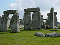
It contains 24 pillars and is 30 metres (98 ft) in diameter and about 4 metres (13 ft) high. The pillars are capped with lintels, completing the circle, and a 5 metres (16 ft)-tall obelisk is near the centre of the henge. [3] From the obelisk, along the meridian line is a 10-metres area called the analemma. The henge is similar to the sarsen cycle of the original Stonehenge and has the same diameter. Entry is via a causeway, which runs due west to the centre. Ten metres outside the circle of the henge stand six heel stones of varying heights.

The modern henge was designed to demonstrate how ancient peoples used such constructions to understand astronomy and also to explain basic astronomical ideas. Visitors are inspired to continue learning both about knowledge that was essential to their ancestors' survival and recent scientific developments. [1]

Stonehenge Aotearoa was also designed to explain the concept of the star compass, like the one used by the Polynesian Navigators. The pillars are not equidistant and their placement reveals important navigational and seasonal stars. Stonehenge Aotearoa also differs from its Salisbury cousin in construction; the pillars, lintels and central obelisk are not hewn stone, but are hollow structures with concrete moulding forming their exterior. If you stand at the centre of the henge, the pillars and lintels appear to form doorways. These frame the rising points of the Sun, the Moon, and bright stars that are either important seasonal markers or navigational beacons. [1]

Equinoxes, solstices and Matariki

As the Earth orbits around the Sun, the north and south poles are alternately tilted towards the Sun. The Sun's altitude therefore increases and decreases during the year, producing seasons. [1]

Stonehenge Aotearoa's six heel stones mark the place where the Sun is rising and setting at solstices and equinoxes.

This sculpture marks the place of the heliacal rising of Matariki around winter solstice at Stonehenge Aotearoa. The fingers of Mother Earth sculpture at Stonehenge Aotearoa.jpg
This sculpture marks the place of the heliacal rising of Matariki around winter solstice at Stonehenge Aotearoa.
Stonehenge Aotearoa has various sculptures placed around the structure. The Fingers of Mother Earth.jpg
Stonehenge Aotearoa has various sculptures placed around the structure.

The stone sculpture "the Fingers of Mother Earth" marks the place where the heliacal rising of Matariki can be observed around the winter solstice in June.

See also

Related Research Articles

Archaeoastronomy Interdisciplinary study of astronomies in cultures

Archaeoastronomy is the interdisciplinary or multidisciplinary study of how people in the past "have understood the phenomena in the sky, how they used these phenomena and what role the sky played in their cultures". Clive Ruggles argues it is misleading to consider archaeoastronomy to be the study of ancient astronomy, as modern astronomy is a scientific discipline, while archaeoastronomy considers symbolically rich cultural interpretations of phenomena in the sky by other cultures. It is often twinned with ethnoastronomy, the anthropological study of skywatching in contemporary societies. Archaeoastronomy is also closely associated with historical astronomy, the use of historical records of heavenly events to answer astronomical problems and the history of astronomy, which uses written records to evaluate past astronomical practice.

Stonehenge Neolithic henge monument in Wiltshire, England

Stonehenge is a prehistoric monument on Salisbury Plain in Wiltshire, England, two miles (3 km) west of Amesbury. It consists of an outer ring of vertical sarsen standing stones, each around 13 feet (4.0 m) high, seven feet (2.1 m) wide, and weighing around 25 tons, topped by connecting horizontal lintel stones. Inside is a ring of smaller bluestones. Inside these are free-standing trilithons, two bulkier vertical Sarsens joined by one lintel. The whole monument, now ruinous, is orientated towards the sunrise on the summer solstice. The stones are set within earthworks in the middle of the most dense complex of Neolithic and Bronze Age monuments in England, including several hundred tumuli.

Ring of Brodgar A neolithic stone circle in Orkney, Scotland

The Ring of Brodgar is a Neolithic henge and stone circle about 6 miles north-east of Stromness on Mainland, the largest island in Orkney, Scotland. It is part of the UNESCO World Heritage Site known as the Heart of Neolithic Orkney.

Newgrange Neolithic monument in County Meath, Ireland

Newgrange is a prehistoric monument in County Meath in Ireland, located on a rise overlooking the River Boyne, 8 kilometres (5.0 mi) west of Drogheda. It is an exceptionally grand passage tomb built during the Neolithic Period, around 3200 BC, making it older than Stonehenge and the Egyptian pyramids. It is aligned on the winter solstice sunrise. Newgrange is the main monument in the Brú na Bóinne complex, a World Heritage Site that also includes the passage tombs of Knowth and Dowth, as well as other henges, burial mounds and standing stones.

Woodhenge

Woodhenge is a Neolithic Class II henge and timber circle monument within the Stonehenge World Heritage Site in Wiltshire, England. It is 2 miles (3.2 km) north-east of Stonehenge, in Durrington parish, just north of the town of Amesbury.

Henge Type of Neolithic earthwork

There are three related types of Neolithic earthwork that are all sometimes loosely called henges. The essential characteristic of all three is that they feature a ring-shaped bank and ditch, with the ditch inside the bank. Because the internal ditches would have served defensive purposes poorly, henges are not considered to have been defensive constructions. The three henge types are as follows, with the figure in brackets being the approximate diameter of the central flat area:

  1. Henge (> 20 m). The word henge refers to a particular type of earthwork of the Neolithic period, typically consisting of a roughly circular or oval-shaped bank with an internal ditch surrounding a central flat area of more than 20 m (66 ft) in diameter. There is typically little if any evidence of occupation in a henge, although they may contain ritual structures such as stone circles, timber circles and coves. Henge monument is sometimes used as a synonym for henge. Henges sometimes, but by no means always, featured stone or timber circles, and circle henge is sometimes used to describe these structures. The three largest stone circles in Britain are each within a henge. Examples of henges without significant internal monuments are the three henges of Thornborough Henges. Although having given its name to the word henge, Stonehenge is atypical in that the ditch is outside the main earthwork bank.
  2. Hengiform monument (5 – 20 m). Like an ordinary henge, except the central flat area is between 5 and 20 m (16–66 ft) in diameter, they comprise a modest earthwork with a fairly wide outer bank. The terms Mini henge or Dorchester henge are sometimes used as synonyms for hengiform monument. An example is the Neolithic site at Wormy Hillock Henge.
  3. Henge enclosure (> 300 m). A Neolithic ring earthwork with the ditch inside the bank, with the central flat area having abundant evidence of occupation and usually being more than 300 m (980 ft) in diameter. Some true henges are as large as this, but lack evidence of domestic occupation. Super henge is sometimes used as a synonym for a henge enclosure. However, sometimes Super henge is used to indicate size alone rather than use, e.g. "Marden henge ... is the least understood of the four British 'superhenges' ".
Durrington Walls

Durrington Walls is the site of a large Neolithic settlement and later henge enclosure located in the Stonehenge World Heritage Site in England. It lies 2 miles (3.2 km) north-east of Stonehenge in the parish of Durrington, just north of Amesbury in Wiltshire. The henge is the second-largest Late Neolithic palisaded enclosure known in the United Kingdom, after Hindwell in Wales.

Harry Aubrey Woodruff Burl HonFSA Scot was a British archaeologist best known for his studies into megalithic monuments and the nature of prehistoric rituals associated with them. Before retirement he was Principal Lecturer in Archaeology, Hull College, East Riding of Yorkshire. Burl received a volume edited in his honour. He was called by The New York Times, "the leading authority on British stone circles".

Bryn Celli Ddu Neolithic burial chamber on Anglesey

Bryn Celli DduWelsh pronunciation: [brʌn keːɬi ðɨː] is a prehistoric site on the Welsh island of Anglesey located near Llanddaniel Fab. Its name means 'the mound in the dark grove'. It was archaeologically excavated between 1928 and 1929. Visitors can get inside the mound through a stone passage to the burial chamber, and it is the centrepiece of a major Neolithic Scheduled Monument in the care of Cadw. The presence of a mysterious pillar within the burial chamber, the reproduction of the 'Pattern Stone', carved with sinuous serpentine designs, and the fact that the site was once a henge with a stone circle, and may have been used to plot the date of the summer solstice have all attracted much interest.

Archaeoastronomy and Stonehenge Stonehenges use in tracking seasons

The prehistoric monument of Stonehenge has long been studied for its possible connections with ancient astronomy. The site is aligned in the direction of the sunrise of the summer solstice and the sunset of the winter solstice. Archaeoastronomers have made a range of further claims about the site's connection to astronomy, its meaning, and its use.

Heel Stone Block of sarsen stone in England

The Heel Stone is a single large block of sarsen stone standing within the Avenue outside the entrance of the Stonehenge earthwork in Wiltshire, England. In section it is sub-rectangular, with a minimum thickness of 2.4 metres, rising to a tapered top about 4.7 metres (15 ft) high. Excavation has shown that a further 1.2 metres is buried in the ground. It is 77.4 metres (254 ft) from the centre of Stonehenge circle. It leans towards the southwest nearly 27 degrees from the vertical. The stone has an overall girth of 7.6 metres (25 ft) and weighs about 35 tons. It is surrounded by the Heelstone Ditch.

This is a list of Stonehenge replicas and derivatives that seeks to collect all the non-ephemeral examples together. The fame of the prehistoric monument of Stonehenge in England has led to many efforts to recreate it, using a variety of different materials, around the world. Some have been carefully built as astronomically aligned models whilst others have been examples of artistic expression or tourist attractions.

Manhattanhenge Four days on which the rising or setting sun aligns with the imperfect East–West street grid of Manhattan in New York City

Manhattanhenge, also inaccurately called the Manhattan Solstice, is an event during which the setting sun or the rising sun is aligned with the east–west streets of the main street grid of Manhattan, New York City. The sunsets and sunrises each align twice a year, on dates evenly spaced around the summer solstice and winter solstice. The sunset alignments occur around May 28 and July 13. The sunrise alignments occur around December 5 and January 8. Excellent places for viewing Manhattanhenge are 14th, 23rd, 34th, 42nd, and 57th Streets.

Mayburgh Henge Neolithic henge in Cumbria, England

Mayburgh Henge is a large prehistoric monument in the county of Cumbria in northern England. The henge is in the care of English Heritage and is a Scheduled Ancient Monument. It is 400 metres from King Arthur's Round Table Henge.

Carahunge

Carahunge, also known as Zorats Karer, Dik-Dik Karer, Tsits Karer and Karenish, is a prehistoric archaeological site near the town of Sisian in the Syunik Province of Armenia. It is also often referred to in international tourist lore as the "Armenian Stonehenge".

Heart of Neolithic Orkney

Heart of Neolithic Orkney refers to a group of Neolithic monuments found on the Mainland of the Orkney Islands, Scotland. The name was adopted by UNESCO when it proclaimed these sites as a World Heritage Site in 1999.

An astronomical complex or commemorative astronomical complex is a series of man-made structures with an astronomical purpose. It has been used when referring to a group of Megalithic structures that it is claimed show high precision astronomical alignments. For the study of Archaeoastronomy, such complexes of similar structures are required for adequate measurement and calculation to ensure that similar celestial sightlines were intended by the designers. These arrangements have also been known as observational, ceremonial or ritual complexes with importance for the study of prehistoric cultures.

Stripple stones

The Stripple stones is a henge and stone circle located on the south slope of Hawk's Tor, Blisland, 10 kilometres (6.2 mi) north northeast of Bodmin on Bodmin Moor in Cornwall, England, UK.

Axial stone circle Type of megalithic monument in counties Cork and Kerry, Ireland

An axial stone circle is a megalithic ring of stones of a particular design found in County Cork and County Kerry in southwest Ireland. Archaeologists have found it convenient to consider the axial five-stone circle and axial multiple-stone circle separately. The circle has an approximate axis of symmetry aligned in a generally northeast–southwest direction. The stone at the southwest side of the circle, rather than being an upright orthostat like all the rest, is a slab lying horizontally with its long thin edge along the circumference of the ring. Because it marks the axis of the circle it is called the axial stone.

References

  1. 1 2 3 4 5 6 Hall, Richard (2005). Stonehenge Aotearoa, The complete guide. New Zealand: AWA Press. p. 3. ISBN   0-9582538-7-0.
  2. "Stonehenge Aotearoa, About Us". Stonehenge Aotearoa. 2020. Retrieved 20 June 2020.
  3. "Stonehenge Aotearoa". Archived from the original on 20 February 2014.

Coordinates: 41°05′59″S175°34′47″E / 41.0998°S 175.5796°E / -41.0998; 175.5796