Stonehenge Riverside Project

Last updated

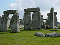
The Stonehenge Riverside Project was a major Arts and Humanities Research Council-funded archaeological research study of the development of the Stonehenge landscape in Neolithic and Bronze Age Britain. In particular, the project examined the relationship between the Stones and surrounding monuments and features, including the River Avon, Durrington Walls, the Cursus, the Avenue, Woodhenge, burial mounds, and nearby standing stones. The project involved a substantial amount of fieldwork and ran from 2003 to 2009. It found that Stonehenge was built 500 years earlier than previously thought. The monument is believed to have been built to unify the peoples of Britain. [1] [2] It also found a previously unknown stone circle, Bluestonehenge.

Contents

Background

The project was directed by Mike Parker Pearson (Sheffield University), Julian Thomas (Manchester University), Colin Richards (Manchester University), Kate Welham (Bournemouth University), Joshua Pollard (University of Southampton), and Chris Tilley (University College London). The main aims of the project were to test the hypotheses of earlier studies that Stonehenge was a monument dedicated to the dead, whilst Woodhenge and Durrington Walls, two miles away, were monuments to the living and more recently deceased.

Previous excavations

The area immediately inside Stonehenge Bowl has been excavated several times throughout history, but to the east around Durrington Walls, there have only been two major studies conducted within recent times. The first was between 1926 and 1929 when Maud Cunnington excavated around Woodhenge, discovering several Neolithic and Bronze Age features to the south. Later, when the nearby A345 was improved and routed through Durrington Walls in 1967, two timber circles were discovered within the henge. Also discovered were quantities of animal bones and associated Neolithic pottery and tools.

Fieldwork

2003 surveys

2003 fieldwork involved sampling and geophysical surveys of the land around Durrington Walls in preparation for future study. This work helped identify two previously unrecognised entranceways to the henge, to the north and south.

2004 excavations

2004 marked the start of annual excavations in the Stonehenge landscape. Trenches were dug on the bank of the River Avon next to Durrington Walls, and at the eastern entrance to the henge. On this occasion various finds suggesting Neolithic occupation were found around the area.

2005 excavations

More fieldwork was carried out in the summer of 2005. Excavations were made around the land east of Durrington Walls near the river, and north west outside the west gate. A large amount of digging was done on the eastern banks of the henge, and inside the walls to expose the southernmost timber circle discovered in 1967. A great deal of work was also carried out 2 miles east, around a fallen sarsen stone known locally as the Bulford Stone. Channel 4's archaeological television programme Time Team attended and built a temporary reconstruction of the timber circle in the nearby village of Upavon.

2006

Over 20 researchers and 170 students and volunteers were involved in excavations around Durrington Walls and investigations into the Stonehenge landscape. Among other things, new dating suggested that the sarsen phase of Stonehenge was contemporary with Durrington Walls at around 2640–2480 BC. [3]

2007 excavations

In late summer of 2007, four weeks of fieldwork was carried out by several hundred students and volunteers. Excavations were carried out at the western end of the Cursus; around the southern, western and eastern gates of Durrington Walls; at the site of Cunnington's digs immediately south of Woodhenge; and around another nearby fallen sarsen stone, known locally as the Cuckoo Stone. Geophysical surveys were also carried out across much of the surrounding area and around Stonehenge Bowl. Residencies for six artists and two graduate art student placements were arranged by Artists in Archaeology to record the processes of uncovering and interpreting this location.

2008 excavations

In the late summer of 2008, a further four weeks of excavations were carried out. The year's excavation focused largely upon the Avenue, largely re-excavating work by Richard Atkinson. More work was carried out upon the eastern end of the Stonehenge Cursus, Long Barrow 42 at the eastern terminal of the Cursus, the field to the west of Stonehenge, and a re-excavation of one of the Aubrey Holes within the Stonehenge bowl. The excavation was covered by Time Team but was also covered by Nova and National Geographic . Residencies for six visual artists were arranged by Artists in Archaeology, to explore connections between archaeological processes and artistic practices.

In 2008, and again in 2009, the team excavated the remains of a henge beside the river, about 1 mile (1.6 km) south-east of Stonehenge. The discovery attracted media coverage and the name "Bluehenge" or "Bluestonehenge". [4] [5]

Stonehenge as a cemetery

Stonehenge is effectively Britain's largest third millennium BC cemetery, containing 52 cremation burials and many other fragments of both burnt and unburnt bone. [6] Many of the cremation deposits contained more than one individual, so that an estimate of the number of people buried here during that period may be between 150 and 240. In 2007 the Stonehenge Riverside Project and the Beaker People Project jointly embarked upon a radiocarbon dating programme of the surviving skeletal remains to establish when Stonehenge was used as a burial space. As a result of this, it is argued that the site began as a cremation cemetery in the early third millennium BC.

Conclusion

The research concluded that Stonehenge was built to unify the people of Stone Age Britain. [1] [2] The results were published in a 2012 book Stonehenge, Exploring the Greatest Stone Age Mystery by Mike Parker Pearson. [7]

Related Research Articles

Stonehenge Neolithic henge monument in Wiltshire, England

Stonehenge is a prehistoric monument in Wiltshire, England, two miles (3 km) west of Amesbury. It consists of a ring of standing stones, each around 13 feet (4.0 m) high, seven feet (2.1 m) wide, and weighing around 25 tons. The stones are set within earthworks in the middle of the most dense complex of Neolithic and Bronze Age monuments in England, including several hundred tumuli.

Woodhenge Neolithic henge and timber circle monument near Stonehenge

Woodhenge is a Neolithic Class II henge and timber circle monument within the Stonehenge World Heritage Site in Wiltshire, England. It is 2 miles (3.2 km) north-east of Stonehenge, just north of the town of Amesbury.

Henge Type of Neolithic earthwork

There are three related types of Neolithic earthwork that are all sometimes loosely called henges. The essential characteristic of all three is that they feature a ring-shaped bank and ditch, with the ditch inside the bank. Because the internal ditches would have served defensive purposes poorly, henges are not considered to have been defensive constructions. The three henge types are as follows, with the figure in brackets being the approximate diameter of the central flat area:

  1. Henge (> 20 m). The word henge refers to a particular type of earthwork of the Neolithic period, typically consisting of a roughly circular or oval-shaped bank with an internal ditch surrounding a central flat area of more than 20 m (66 ft) in diameter. There is typically little if any evidence of occupation in a henge, although they may contain ritual structures such as stone circles, timber circles and coves. Henge monument is sometimes used as a synonym for henge. Henges sometimes, but by no means always, featured stone or timber circles, and circle henge is sometimes used to describe these structures. The three largest stone circles in Britain are each within a henge. Examples of henges without significant internal monuments are the three henges of Thornborough Henges. Although having given its name to the word henge, Stonehenge is atypical in that the ditch is outside the main earthwork bank.
  2. Hengiform monument (5 – 20 m). Like an ordinary henge, except the central flat area is between 5 and 20 m (16–66 ft) in diameter, they comprise a modest earthwork with a fairly wide outer bank. The terms Mini henge or Dorchester henge are sometimes used as synonyms for hengiform monument. An example is the Neolithic site at Wormy Hillock Henge.
  3. Henge enclosure (> 300 m). A Neolithic ring earthwork with the ditch inside the bank, with the central flat area having abundant evidence of occupation and usually being more than 300 m (980 ft) in diameter. Some true henges are as large as this, but lack evidence of domestic occupation. Super henge is sometimes used as a synonym for a henge enclosure. However, sometimes Super henge is used to indicate size alone rather than use, e.g. "Marden henge ... is the least understood of the four British 'superhenges' ".
Avebury Neolithic henge monument

Avebury is a Neolithic henge monument containing three stone circles, around the village of Avebury in Wiltshire, in southwest England. One of the best known prehistoric sites in Britain, it contains the largest megalithic stone circle in the world. It is both a tourist attraction and a place of religious importance to contemporary pagans.

Durrington Walls Neolithic henge monument; stone circle

Durrington Walls is the site of a large Neolithic settlement and later henge enclosure located in the Stonehenge World Heritage Site in England. It lies 2 miles (3.2 km) north-east of Stonehenge in the parish of Durrington, just north of Amesbury.

Thornborough Henges Neolithic henge complex in North Yorkshire, England

The Thornborough Henges are an unusual ancient monument complex that includes the three aligned henges that give the site its name. The complex is located near the village of Thornborough, close to the town of Masham in North Yorkshire, England. The complex includes many large ancient structures including a cursus, henges, burial grounds and settlements.

Aubrey holes Neolithic monument

The Aubrey holes are a ring of fifty-six (56) chalk pits at Stonehenge, named after the seventeenth-century antiquarian John Aubrey. They date to the earliest phases of Stonehenge in the late fourth and early third millennium BC. Despite decades of argument and analysis, their purpose is still unknown, although an astronomical role has often been suggested.

Michael 'Mike' Parker Pearson, FSA, FSA Scot, FBA is an English archaeologist specialising in the study of the Neolithic British Isles, Madagascar and the archaeology of death and burial, and is known for his catchphrase "The Dead Don't Bury Themselves". A professor at the UCL Institute of Archaeology, he previously worked for 25 years as a professor at the University of Sheffield in England, and was the director of the Stonehenge Riverside Project. A prolific author, he has also written a variety of books on the subject.

The Arts and Humanities Research Council (AHRC) was established in April 2005 as successor to the Arts and Humanities Research Board and is a British research council; non-departmental public body that provides approximately £102 million from the government to support research and postgraduate study in the arts and humanities, from languages and law, archaeology and English literature to design and creative and performing arts. In any one year, the AHRC makes approximately 700 research awards and around 1,350 postgraduate awards. Postgraduate funding is organised through Doctoral Training Partnerships in 10 consortia that bring together a total of 72 higher education institutions throughout the UK. Awards are made after a rigorous peer review process, to ensure that only applications of the highest quality are funded.

Stonehenge Landscape Estate owned by the National Trust of England

The Stonehenge Landscape is a property of The National Trust, located on Salisbury Plain in Wiltshire, England. The estate covers 2,100 acres (850 ha) surrounding the neolithic monument of Stonehenge, which is administered by English Heritage. Much of the land is designated open access by the Trust, including the fields immediately around Stonehenge and other fields that become available as part of the chalk grassland reversion project. Stonehenge itself is in the care of English Heritage, having been given to the nation in 1918 by Cecil and Mary Chubb, who had bought it three years previously from the Antrobus family.

Robin Hood’s Ball is a Neolithic causewayed enclosure on Salisbury Plain in Wiltshire, England. It is approximately 5 miles (8 km) northwest of the town of Amesbury, and 2 12 miles (4.0 km) northwest of Stonehenge. It was formerly known as Neath Barrow.

Records of archaeological excavations at the Stonehenge site date back to the early 17th century.

Stonehenge, Avebury and Associated Sites World Heritage Site

Stonehenge, Avebury and Associated Sites is a UNESCO World Heritage site (WHS) located in Wiltshire, England. The WHS covers two large areas of land separated by nearly 30 miles (48 km), rather than a specific monument or building. The sites were inscribed as co-listings in 1986. Some of the large and well known monuments within the WHS are listed below, but the area also has an exceptionally high density of small-scale archaeological sites, particularly from the prehistoric period. More than 700 individual archaeological features have been identified. There are 160 separate Scheduled Monuments, covering 415 items or features.

Theories about Stonehenge Theories on the origin and purpose of Stonehenge

Stonehenge has been the subject of many theories about its origin, ranging from the academic worlds of archaeology to explanations from mythology and the paranormal.

Joshua Pollard is a British archaeologist who is a Professor of Archaeology at the University of Southampton. He gained his BA and PhD in Archaeology from the Cardiff University, and has specialised in the archaeology of the Neolithic period in the UK and north-west Europe, especially in relation to the study of depositional practices, monumentality, and landscape. He is a Fellow of the Society of Antiquaries of London

Vespasians Camp hillfort in Wiltshire, UK

Vespasian's Camp is an Iron Age hillfort close to the town of Amesbury, Wiltshire, England. The camp is less than 3 kilometres (2 mi) from the Neolithic and Bronze Age site of Stonehenge and was built on a hill next to the Stonehenge Avenue and borders the River Avon on its southern side and the A303 on its northern edge. It is inside the boundaries of the Stonehenge World Heritage Site.

Bluestonehenge Neolithic henge monument

Bluestonehenge or Bluehenge is a prehistoric henge and stone circle monument that was discovered by the Stonehenge Riverside Project about 1 mile (1.6 km) south-east of Stonehenge in Wiltshire, England. All that remains of the site is the ditch of the henge and a series of stone settings, none of which is visible above ground.

Julian Stewart Thomas is a British archaeologist, publishing on the Neolithic and Bronze Age prehistory of Britain and north-west Europe. Thomas has been vice president of the Royal Anthropological Institute since 2007, is a fellow of the Society of Antiquaries of London, has been professor of archaeology at the University of Manchester since 2000, and is former secretary of the World Archaeological Congress. Thomas is perhaps best known as the author of the academic publication Understanding the Neolithic in particular, and for his work with the Stonehenge Riverside Project.

Marden Henge Neolithic henge monument

Marden Henge is the largest Neolithic henge enclosure discovered to date in the United Kingdom. The monument is northeast of the village of Marden, Wiltshire, within the Vale of Pewsey and between the World Heritage sites of Avebury and Stonehenge.

Cuckoo Stone

The Cuckoo Stone is a Neolithic or Bronze Age standing stone. The stone, which is now fallen, is in a field near to Woodhenge and Durrington Walls in Wiltshire, England. It is part of the wider Stonehenge Landscape.

References

  1. 1 2 "Stonehenge was built to unify Britain, researchers conclude". BBC. 22 June 2012. Retrieved 28 April 2013.
  2. 1 2 "Research finds Stonehenge was monument marking unification of Britain". Sheffield University. 22 June 2012. Retrieved 28 April 2013.
  3. "2006 Interim Report" (PDF). Stonehenge Riverside Project.
  4. "Mini-Stonehenge find 'important'". BBC. 3 October 2009. Retrieved 3 October 2009.
  5. "Archaeologist at University finds 'Bluestonehenge' site". Sheffield University. 5 October 2009. Retrieved 6 October 2009.
  6. Parker Pearson M, Chamberlain A, Jay M, Marshall P, Pollard J, Richards C, Thomas J, Tilley C, Welham K (2009). "Who was buried at Stonehenge?". Antiquity. 83 (319): 23–39.
  7. Mike Parker Pearson (June 2012). Stonehenge, Exploring the Greatest Stone Age Mystery. UK: Simon & Schuster. ISBN   9780857207302.