Stonehenge is a prehistoric monument on Salisbury Plain in Wiltshire, England, two miles (3 km) west of Amesbury. It consists of an outer ring of vertical sarsen standing stones, each around 13 feet (4.0 m) high, seven feet (2.1 m) wide, and weighing around 25 tons, topped by connecting horizontal lintel stones. Inside is a ring of smaller bluestones. Inside these are free-standing trilithons, two bulkier vertical sarsens joined by one lintel. The whole monument, now ruinous, is aligned towards the sunrise on the summer solstice. The stones are set within earthworks in the middle of the densest complex of Neolithic and Bronze Age monuments in England, including several hundred tumuli.

Woodhenge is a Neolithic Class II henge and timber circle monument within the Stonehenge World Heritage Site in Wiltshire, England. It is 2 miles (3.2 km) north-east of Stonehenge, in Durrington parish, just north of the town of Amesbury.

The Goseck Circle is a Neolithic structure in Goseck in the Burgenlandkreis district in Saxony-Anhalt, Germany.

Durrington Walls is the site of a large Neolithic settlement and later henge enclosure located in the Stonehenge World Heritage Site in England. It lies 2 miles (3.2 km) north-east of Stonehenge in the parish of Durrington, just north of Amesbury in Wiltshire. The henge is the second-largest Late Neolithic palisaded enclosure known in the United Kingdom, after Hindwell in Wales.

The Sanctuary was a stone and timber circle near the village of Avebury in the south-western English county of Wiltshire. Excavation has revealed the location of the 58 stone sockets and 62 post-holes. The ring was part of a tradition of stone circle construction that spread throughout much of Britain, Ireland, and Brittany during the Late Neolithic and Early Bronze Age, over a period between 3300 and 900 BCE. The purpose of such monuments is unknown, although archaeologists speculate that the stones represented supernatural entities for the circle's builders.

In archaeology, timber circles are rings of upright wooden posts, built mainly by ancient peoples in the British Isles and North America. They survive only as gapped rings of post-holes, with no evidence they formed walls, making them distinct from palisades. Like stone circles, it is believed their purpose was ritual, ceremonial, and/or astronomical.
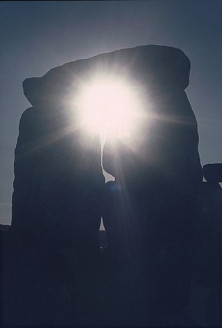
The prehistoric monument of Stonehenge has long been studied for its possible connections with ancient astronomy. The site is aligned in the direction of the sunrise of the summer solstice and the sunset of the winter solstice. Archaeoastronomers have made a range of further claims about the site's connection to astronomy, its meaning, and its use.
This is a list of Stonehenge replicas and derivatives that seeks to collect all the non-ephemeral examples together. The fame of the prehistoric monument of Stonehenge in England has led to many efforts to recreate it, using a variety of different materials, around the world. Some have been carefully built as astronomically aligned models whilst others have been examples of artistic expression or tourist attractions.

Manhattanhenge, also inaccurately called the Manhattan Solstice, is an event during which the setting sun or the rising sun is aligned with the east–west streets of the main street grid of Manhattan, New York City. The astrophysicist Neil deGrasse Tyson has said that he coined the term, by analogy with Stonehenge. The sunsets and sunrises each align twice a year, on dates evenly spaced around the summer solstice and winter solstice. The sunset alignments occur around May 28 and July 13. The sunrise alignments occur around December 5 and January 8.

The winter solstice, also called the hibernal solstice, occurs when either of Earth's poles reaches its maximum tilt away from the Sun. This happens twice yearly, once in each hemisphere. For that hemisphere, the winter solstice is the day with the shortest period of daylight and longest night of the year, when the Sun is at its lowest daily maximum elevation in the sky. Either pole experiences continuous darkness or twilight around its winter solstice. The opposite event is the summer solstice.
Stonehenge has been the subject of many theories about its origin, ranging from the academic worlds of archaeology to explanations from mythology and the paranormal.

Bush Barrow is a site of the early British Bronze Age Wessex culture, at the western end of the Normanton Down Barrows cemetery in Wiltshire, England. It is among the most important sites of the Stonehenge complex, having produced some of the most spectacular grave goods in Britain. It was excavated in 1808 by William Cunnington for Sir Richard Colt Hoare. The finds, including worked gold objects, are displayed at Wiltshire Museum in Devizes.

Stonehenge in its landscape: Twentieth century excavations by Rosamund M. J. Cleal, Karen E. Walker and Rebecca Montague is an archaeological report on Stonehenge published in 1995. It presented the results of a two-year intensive study of all the known records of the various excavations at Stonehenge in the twentieth century, including a rephasing of the development of the monument.
Vespasian's Camp is an Iron Age hillfort just west of the town of Amesbury, Wiltshire, England. The hillfort is less than 3 kilometres (2 mi) from the Neolithic and Bronze Age site of Stonehenge, and was built on a hill next to the Stonehenge Avenue; it has the River Avon on its southern side and the A303 road on its northern edge. The site is a scheduled monument and lies within the boundaries of the Stonehenge World Heritage Site.

Arthur Uther Pendragon is a British eco-campaigner, Neo-Druid leader, media personality, and self-declared reincarnation of King Arthur, a name by which he is also known. Pendragon was the "battle chieftain" of the Council of British Druid Orders.

The Q and R Holes are a series of concentric sockets which currently represent the earliest known evidence for a stone structure on the site of Stonehenge.
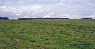
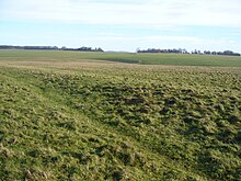
The Stonehenge Cursus is a large Neolithic cursus monument on Salisbury plain, near to Stonehenge in Wiltshire, England. It is roughly 3 kilometres (1.9 mi) long and between 100 metres (330 ft) and 150 metres (490 ft) wide. Excavations in 2007 dated the construction of the earthwork to between 3630 and 3375 BCE, several hundred years before the earliest phase of Stonehenge in 3000 BC. The cursus, along with adjacent barrows and the nearby 'Lesser Cursus' are part of the National Trust's Stonehenge Landscape property, and is within the Stonehenge and Avebury World Heritage Site.

Bluestonehenge or Bluehenge is a prehistoric henge and stone circle monument that was discovered by the Stonehenge Riverside Project about 1 mile (1.6 km) south-east of Stonehenge in Wiltshire, England. All that remains of the site is the ditch of the henge and a series of stone settings, none of which is visible above ground.

The Cahokia Woodhenge was a series of large timber circles located roughly 850 metres (2,790 ft) to the west of Monks Mound at the Mississippian culture Cahokia archaeological site near Collinsville, Illinois. They are thought to have been constructed between 900 and 1100 CE; with each one being larger and having more posts than its predecessor. The site was discovered as part of salvage archaeology in the early 1960s interstate highway construction boom, and one of the circles was reconstructed in the 1980s. The circle has been used to investigate archaeoastronomy at Cahokia. Annual equinox and solstice sunrise observation events are held at the site.