Stonehenge is a prehistoric megalithic structure on Salisbury Plain in Wiltshire, England, two miles (3 km) west of Amesbury. It consists of an outer ring of vertical sarsen standing stones, each around 13 feet (4.0 m) high, seven feet (2.1 m) wide, and weighing around 25 tons, topped by connecting horizontal lintel stones, held in place with mortise and tenon joints, a feature unique among contemporary monuments. Inside is a ring of smaller bluestones. Inside these are free-standing trilithons, two bulkier vertical sarsens joined by one lintel. The whole monument, now ruinous, is aligned towards the sunrise on the summer solstice and sunset on the winter solstice. The stones are set within earthworks in the middle of the densest complex of Neolithic and Bronze Age monuments in England, including several hundred tumuli.

Woodhenge is a Neolithic Class II henge and timber circle monument within the Stonehenge World Heritage Site in Wiltshire, England. It is 2 miles (3.2 km) northeast of Stonehenge, in Durrington parish, just north of the town of Amesbury.

A henge loosely describes one of three related types of Neolithic earthwork. The essential characteristic of all three is that they feature a ring-shaped bank and ditch, with the ditch inside the bank. Because the internal ditches would have served defensive purposes poorly, henges are not considered to have been defensive constructions. The three henge types are as follows, with the figure in brackets being the approximate diameter of the central flat area:
- Henge. The word henge refers to a particular type of earthwork of the Neolithic period, typically consisting of a roughly circular or oval-shaped bank with an internal ditch surrounding a central flat area of more than 20 m (66 ft) in diameter. There is typically little if any evidence of occupation in a henge, although they may contain ritual structures such as stone circles, timber circles and coves. Henge monument is sometimes used as a synonym for henge. Henges sometimes, but by no means always, featured stone or timber circles, and circle henge is sometimes used to describe these structures. The three largest stone circles in Britain are each within a henge. Examples of henges without significant internal monuments are the three henges of Thornborough Henges. Although having given its name to the word henge, Stonehenge is atypical in that the ditch is outside the main earthwork bank.
- Hengiform monument. Like an ordinary henge, except the central flat area is between 5 and 20 m (16–66 ft) in diameter, they comprise a modest earthwork with a fairly wide outer bank. The terms mini-henge or Dorchester henge are sometimes used as synonyms for hengiform monument. An example is the Neolithic site at Wormy Hillock Henge.
- Henge enclosure. A Neolithic ring earthwork with the ditch inside the bank, with the central flat area having abundant evidence of occupation and usually being more than 300 m (980 ft) in diameter. Some true henges are as large as this, but lack evidence of domestic occupation. Super-henge or superhenge is sometimes used as a synonym for a henge enclosure. However, sometimes the term is used to indicate size alone rather than use, e.g. "Marden henge ... is the least understood of the four British 'superhenges' ".

Avebury is a Neolithic henge monument containing three stone circles, around the village of Avebury in Wiltshire, in south-west England. One of the best-known prehistoric sites in Britain, it contains the largest megalithic stone circle in the world. It is both a tourist attraction and a place of religious importance to contemporary pagans.

Durrington Walls is the site of a large Neolithic settlement and later henge enclosure located in the Stonehenge World Heritage Site in England. It lies 2 miles (3.2 km) north-east of Stonehenge in the parish of Durrington, just north of Amesbury in Wiltshire. The henge is the second-largest Late Neolithic palisaded enclosure known in the United Kingdom, after Hindwell in Wales.
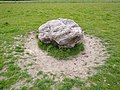
The Aubrey holes are a ring of 56 chalk pits at Stonehenge, named after seventeenth-century antiquarian John Aubrey. They date to the earliest phases of Stonehenge in the late fourth and early third millennium BC. Despite decades of argument and analysis, their purpose is still unknown, although an astronomical role has often been suggested.

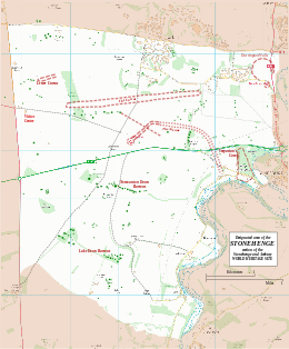
The Stonehenge Landscape is a property of The National Trust, located on Salisbury Plain in Wiltshire, England. The estate covers 2,100 acres (850 ha) surrounding the neolithic monument of Stonehenge, which is administered by English Heritage. Much of the land is designated open access by the Trust, including the fields immediately around Stonehenge and other fields that become available as part of the chalk grassland reversion project. Stonehenge itself is in the care of English Heritage, having been given to the nation in 1918 by Cecil and Mary Chubb, who had bought it three years previously from the Antrobus family.
Records of archaeological excavations at the Stonehenge site date back to the early 17th century.
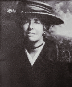
Maud Edith Cunnington was a Welsh archaeologist, best known for her pioneering work on some of the most important prehistoric sites of Salisbury Plain.
Stonehenge, Avebury and Associated Sites is a UNESCO World Heritage Site (WHS) in Wiltshire, England. The WHS covers two large areas of land separated by about 24 kilometres (15 mi), rather than a specific monument or building. The sites were inscribed as co-listings in 1986. Some large and well known monuments within the WHS are listed below, but the area also has an exceptionally high density of small-scale archaeological sites, particularly from the prehistoric period. More than 700 individual archaeological features have been identified. There are 160 separate scheduled monuments, covering 415 items or features.
Stonehenge has been the subject of many theories about its origin, ranging from the academic worlds of archaeology to explanations from mythology and the paranormal.
The Stonehenge Riverside Project was a major Arts and Humanities Research Council-funded archaeological research study of the development of the Stonehenge landscape in Neolithic and Bronze Age Britain. In particular, the project examined the relationship between the stones and surrounding monuments and features, including the River Avon, Durrington Walls, the Cursus, the Avenue, Woodhenge, burial mounds, and nearby standing stones. The project involved a substantial amount of fieldwork and ran from 2003 to 2009. It found that Stonehenge was built 500 years earlier than previously thought. The monument is believed to have been built to unify the peoples of Britain. It also found a previously unknown stone circle, Bluestonehenge.
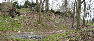
Vespasian's Camp is an Iron Age hillfort just west of the town of Amesbury, Wiltshire, England. The hillfort is less than 3 kilometres (2 mi) from the Neolithic and Bronze Age site of Stonehenge, and was built on a hill next to the Stonehenge Avenue; it has the River Avon on its southern side and the A303 road on its northern edge. The site is a scheduled monument and lies within the boundaries of the Stonehenge World Heritage Site.

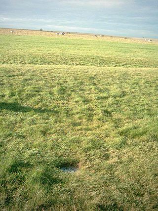
The Y and Z Holes are two rings of concentric circuits of 30 and 29 near-identical pits cut around the outside of the Sarsen Circle at Stonehenge. The current view is that both circuits are contemporary. Radiocarbon dating of antlers deliberately placed in hole Y 30 provided a date of around 1600 BCE, and a slightly earlier date was determined for material retrieved from Z 29. These dates make the Y and Z holes the last known structural activity at Stonehenge.

The Q and R Holes are a series of concentric sockets which currently represent the earliest known evidence for a stone structure on the site of Stonehenge.
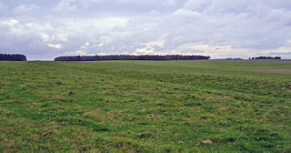
The Stonehenge Cursus is a large Neolithic cursus monument on Salisbury plain, near to Stonehenge in Wiltshire, England. It is roughly 3 kilometres (1.9 mi) long and between 100 metres (330 ft) and 150 metres (490 ft) wide. Excavations in 2007 dated the construction of the earthwork to between 3630 and 3375 BCE, several hundred years before the earliest phase of Stonehenge in 3000 BC. The cursus, along with adjacent barrows and the nearby 'Lesser Cursus' are part of the National Trust's Stonehenge Landscape property, and is within the Stonehenge and Avebury World Heritage Site.

The Sannai-Maruyama Site is an archaeological site and museum located in the Maruyama and Yasuta neighborhoods to the southwest of central Aomori in Aomori Prefecture in northern Japan, containing the ruins of a very large Jōmon period settlement. The ruins of a 40-hectare settlement were discovered in 1992, when Aomori Prefecture started surveying the area for a planned baseball stadium. Archaeologists have used this site to further their understanding of the transition to sedentism and the life of the Jōmon people. Excavation has led to the discovery of storage pits, above ground storage and long houses. These findings demonstrate a change in the structure of the community, architecture, and organizational behaviors of these people. Because of the extensive information and importance, this site was designated as a Special National Historical Site of Japan in 2000., and a UNESCO World Heritage Site as part of the Jōmon Prehistoric Sites in Northern Japan collection in 2021. Today the public can visit the site, its various reconstructions of Jōmon structures, and a museum that displays and houses artifacts collected on the site, which have collectively been designated an Important Cultural Property

Bluestonehenge or Bluehenge is a prehistoric henge and stone circle monument that was discovered by the Stonehenge Riverside Project about 1 mile (1.6 km) south-east of Stonehenge in Wiltshire, England. All that remains of the site is the ditch of the henge and a series of stone settings, none of which is visible above ground.
Julian Stewart Thomas is a British archaeologist, publishing on the Neolithic and Bronze Age prehistory of Britain and north-west Europe. Thomas has been vice president of the Royal Anthropological Institute since 2007. He has been Professor of Archaeology at the University of Manchester since 2000, and is former secretary of the World Archaeological Congress. Thomas is perhaps best known as the author of the academic publication Understanding the Neolithic in particular, and for his work with the Stonehenge Riverside Project.