Withypool Stone Circle

Last updated

Withypool Stone Circle
Stone Circle on Withypool Hill - geograph.org.uk - 53966.jpg
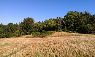
The location of the circle in 2005; the stones are so small that discerning the site is difficult
Somerset UK location map.svg
Archaeological site icon (red).svg
Shown within Somerset
Location Withypool
Coordinates 51°05′47″N3°39′37″W / 51.0963°N 3.6604°W / 51.0963; -3.6604
Type Stone circle
History
Periods Neolithic / Bronze Age
Official nameStone circle on Withypool Hill 670m ESE of Portford Bridge
Designated30 November 1925
Reference no.1021261

Withypool Stone Circle, also known as Withypool Hill Stone Circle, is a stone circle located on the Exmoor moorland, near the village of Withypool in the southwestern English county of Somerset. The ring is part of a tradition of stone circle construction that spread throughout much of Britain, Ireland, and Brittany during the Late Neolithic and Early Bronze Age, over a period between 3300 and 900 BCE. The purpose of such monuments is unknown, although archaeologists speculate that the stones represented supernatural entities for the circle's builders.

Contents

Many monuments were built in Exmoor during the Bronze Age, but only two stone circles survive in this area: the other is Porlock Stone Circle. The Withypool ring is located on the south-western slope of Withypool Hill, on an area of heathland. It is about 36.4 metres (119 feet 5 inches) in diameter. Around thirty small gritstones remain, although there may originally have been around 100; there are conspicuous gaps on the northern and western sides of the monument. The site was rediscovered in 1898 and surveyed by the archaeologist Harold St George Gray in 1905.

Location

Withypool Stone Circle is located on the south-western slope of Withypool Hill; [1] some sources refer to it as Withypool Hill Stone Circle. [2] The site is 381 metres (1,250 feet) above sea level. [3] It is 670 metres (730 yards) east of Portford Bridge, [4] and 4.4 kilometres (2.7 miles) south/south-west of Exford. [5]

The site slopes down from east to west. [4] The topsoil is peaty with heather. [4] A range of different Bronze Age round barrows, a type of tumulus, are visible at different points in the surrounding landscape. [5] There is a lone tumulus 262 metres (287 yards) to the north-east of the circle, on the summit of Withypool Hill, although this is so eroded that it can no longer be seen from Withypool Stone Circle itself. [3] The three Brightworthy Barrows can be seen from the circle in a north-west direction. [3] Other Bronze Age barrows visible from the circle are the Green Barrow, the Old Barrow, the Twitchen Barrows, the three Wam Barrows of Winsford Hill, and the barrow on top of Sherdon. [3]

Also visible from the circle is a scatter of over thirty stones on the Westwater Allotment; these are up to 0.5 m (1.6 ft) long and in 1988 two were reported as being standing. [6] Elsewhere on Withypool Common is a collection of six stones arranged in a rough circle, which may have represented another stone circle or perhaps the kerbstones from a since-destroyed round cairn. [7]

Context

Withypool Stone Circle (geograph 4591136).jpg
Withypool Stone Circle, May 2014 II.jpg
Stones present on the two ends of the circle

While the transition from the Early Neolithic to the Late Neolithic in the fourth and third millennia BCE saw much economic and technological continuity, there was a considerable change in the style of monuments erected, particularly in what is now southern and eastern England. [8] By 3000 BCE, the long barrows, causewayed enclosures, and cursuses which had predominated in the Early Neolithic were no longer built, and had been replaced by circular monuments of various kinds. [8] These include earthen henges, timber circles, and stone circles. [9] Stone circles are found in most areas of Britain where stone is available, with the exception of the island's south-eastern corner. [10] They are most densely concentrated in south-western Britain and on the north-eastern horn of Scotland, near Aberdeen. [10] The tradition of their construction may have lasted for 2,400 years, from 3300 to 900 BCE, with the major phase of building taking place between 3000 and 1,300 BCE. [11]

These stone circles typically show very little evidence of human visitation during the period immediately following their creation. [12] This suggests that they were not sites used for rituals that left archaeologically visible evidence, but may have been deliberately left as "silent and empty monuments". [13] The archaeologist Mike Parker Pearson suggests that in Neolithic Britain, stone was associated with the dead, and wood with the living. [14] Other archaeologists have suggested that the stones might not represent ancestors, but rather other supernatural entities, such as deities. [13]

Stone circles in Exmoor

There are only two known prehistoric stone circles on Exmoor: Withypool and Porlock Stone Circle. [15] The archaeologist Leslie Grinsell suggested that the circular stone monument on Almsworthy Common was "probably" the remains of a stone circle, [16] although more recent assessments regard it one of the stone settings, a different form of monument which is more common across Exmoor. [17]

Withypool Stone Circle in its landscape context, 2014 Withypool Stone Circle, May 2014.jpg
Withypool Stone Circle in its landscape context, 2014

Archaeologists have dated these circles to the Late Neolithic or Early Bronze Age, [18] and have noted that they are comparable to the stone circles found further south, on Dartmoor. [18] In contrast to the two known Exmoor circles, over seventy such monuments have been identified on Dartmoor. [19] This may be because Exmoor, unlike Dartmoor, has no natural granite. [19] Instead it has Devonian slates and Hangman Grits, both of which easily break up into small slabs, resulting in a general shortage of big stones on Exmoor. [19]

This scarcity of large stones may explain why Neolithic and Bronze Age communities used small stones, termed miniliths, in the two Exmoor circles and in other monuments within the region. There are nevertheless other constructions in the area, such as the clapper bridge at Tarr Steps and the three-metre Long Stone at Challacombe, which do use locally sourced large megaliths. This suggests that larger stones would have been available had the sites' builders desired, and that the use of miniliths was therefore deliberate. [20]

Exmoor also has a henge, near Parracombe, although it has been damaged by ploughing. [19] Alongside this, the moor bears a profusion of other Bronze Age monuments, including between 300 and 400 round barrows, standing stones, linear stone rows, and stone settings. [19] The creation of these different monument types might also explain why so few stone circles were apparently created here. [21] Most of the surviving prehistoric stone monuments on Exmoor are located on those areas of moorland outside the limits of medieval and post-medieval agriculture. For this reason it is likely that the surviving sites are not a reliable indicator of the original extent of these sites. [18]

Description

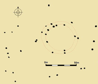
Plan of the site as it existed in 1905 Withypool Stone Circle Plan.jpg
Plan of the site as it existed in 1905

The stone circle measures 36.4 metres (119 feet 5 inches) in diameter. [22] In 1905, there were 37 stones remaining in the circle. [22] At the time there were conspicuous gaps on the northern and western sides of the ring; the stones perhaps in these areas may have been removed for use as road metal. [23] There are ground depressions where some of these stones have been removed. [24] In 1915 it was reported that one had been removed but that three additional stones had been found in the circle. [25] By 1988, Martin J. F. Fowler reported that there were only 29 stones in the circle. [6] Conversely, the following year the archaeologist Aubrey Burl reported 30 stones, of which three had fallen and 27 remained standing. [5] Originally it may have included around 100 stones, spaced about one metre (3 feet 3 inches) apart. [26]

The stones themselves are small: on average they measure 10 cm (3.9 in) in height, 30 cm (one foot) in width, and 10 cm (3.9 in) in depth. [5] The largest protrudes about 0.5 metres (1 foot 8 inches) from the ground. [6] Most are incomplete, and likely have been broken since the original erection of the circle. [27] It is not known if all the stones in the circle come from the same natural rock, but a sample from one stone was examined and found to be a hard, pale grey gritstone, likely taken from the nearby Pickwell Down grits. [28] There are conspicuous quartz veins in many of the circle's stones. [28]

Investigation

The site was accidentally rediscovered in 1898 when Archibald Hamilton was riding across Withypool Heath. His horse stumbled on one of the stones, and on further investigation he located other stones within the bracken. [29] After the bracken on the heath was burned by farmers, Hamilton returned to pay closer attention to the circle. [30] He contacted Colonel Bramble, the Vice President of the Somerset Archaeological and Natural History Society, who put him in touch with the archaeologist Harold St George Gray. [4] Gray accompanied Hamilton on a visit to the site in August 1905, when he made a complete survey of the ring. [31]

Gray published his findings in a 1906 volume of the Proceedings of the Somerset Archaeological and Natural History Society, in which he drew comparisons between the site and two Cornish stone circles that he had recently surveyed, Fernacre and Stannon Stone Circle. [32] He suggested that the circle had been the site of cremations, the cremated human remains then being buried within the nearby tumuli. [33] In August 1915, Gray returned to the site. [34] He noted that the circle was in largely the same condition as before, but that the ling and whortleberry bushes around the site were more stunted than they had previously been. [35] Between 1982 and 1985, Fowler visited Withypool Stone Circle alongside other prehistoric stone monuments in Exmoor for a catalogue published in a 1988 edition of the Proceedings. [36]

The site has been designatedas a scheduled monument since 1925, and is thus accorded legal protection under the Ancient Monuments and Archaeological Areas Act 1979. [24] [37]

Related Research Articles

<span class="mw-page-title-main">The Sanctuary</span> Prehistoric site in Wiltshire, England

The Sanctuary was a stone and timber circle near the village of Avebury in the south-western English county of Wiltshire. Excavation has revealed the location of the 58 stone sockets and 62 post-holes. The ring was part of a tradition of stone circle construction that spread throughout much of Britain, Ireland, and Brittany during the Late Neolithic and Early Bronze Age, over a period between 3300 and 900 BCE. The purpose of such monuments is unknown, although archaeologists speculate that the stones represented supernatural entities for the circle's builders.

<span class="mw-page-title-main">Medway Megaliths</span> Group of long barrows in Kent, England

The Medway Megaliths, sometimes termed the Kentish Megaliths, are a group of Early Neolithic chambered long barrows and other megalithic monuments located in the lower valley of the River Medway in Kent, South-East England. Constructed from local sarsen stone and soil between the 4th and 3rd millennia BCE, they represent the only known prehistoric megalithic group in eastern England and the most south-easterly group in Britain.

<span class="mw-page-title-main">Little Kit's Coty House</span> Dolmen in England

Little Kit's Coty House, also known as Lower Kit's Coty House and the Countless Stones, is a chambered long barrow located near to the village of Aylesford in the southeastern English county of Kent. Constructed circa 4000 BCE, during the Early Neolithic period of British prehistory, today it survives in a ruined state.

<span class="mw-page-title-main">Addington Long Barrow</span> Chambered long barrow in Kent, England

Addington Long Barrow is a chambered long barrow located near the village of Addington in the southeastern English county of Kent. Probably constructed in the fourth millennium BCE, during Britain's Early Neolithic period, today it survives only in a ruined state. Built of earth and about fifty local sarsen megaliths, the long barrow consisted of a sub-rectangular earthen tumulus enclosed by kerb-stones. Collapsed stones on the northeastern end of the chamber probably once formed a stone chamber in which human remains might have been deposited, though none have been discovered.
<span class="mw-page-title-main">Julliberrie's Grave</span> Long barrow in Kent, England

Julliberrie's Grave, also known as The Giant's Grave or The Grave, is an unchambered long barrow located near to the village of Chilham in the south-eastern English county of Kent. Probably constructed in the fourth millennium BCE, during Britain's Early Neolithic period, today it survives only in a state of ruin.

<span class="mw-page-title-main">Hoarstones</span> Stone circle in Shropshire, England

The Hoarstones, or Hoar Stone Circle, is a stone circle in the civil parish of Chirbury with Brompton in the English county of Shropshire. The Hoarstones are part of a tradition of stone circle construction that spread throughout much of Britain, Ireland, and Brittany during the Late Neolithic and Early Bronze Ages, over a period between 3300 and 900 BCE. The purpose of such monuments is unknown.

The Whetstones are, or were, a stone circle beneath Corndon Hill in the parish of Church Stoke, Montgomeryshire, Wales, near the border with Shropshire, England. They lie immediately to the west of the village of White Grit and close to Priestweston. The site is also a short distance from the better-known Hoarstones and Mitchell's Fold circles.

<span class="mw-page-title-main">Stone circles in the British Isles and Brittany</span> Megalithic tradition of monuments

The stone circles in the British Isles and Brittany are a megalithic tradition of monuments consisting of standing stones arranged in rings. These were constructed from 3300 to 900 BCE in Britain, Ireland and Brittany. It has been estimated that around 4,000 of these monuments were originally constructed in this part of north-western Europe during this period. Around 1,300 of them are recorded, the others having been destroyed.

<span class="mw-page-title-main">Rempstone Stone Circle</span> Stone circle near Corfe Castle in Dorset, England

Rempstone Stone Circle is a stone circle located near to Corfe Castle on the Isle of Purbeck in the south-western English county of Dorset. Archaeologists believe that it was likely erected during the Bronze Age. The Rempstone ring is part of a tradition of stone circle construction that spread throughout much of Britain, Ireland, and Brittany during the Late Neolithic and Early Bronze Age, over a period between 3,300 and 900 BC. The purpose of such monuments is unknown, although archaeologists speculate that they were likely religious sites, with the stones perhaps having supernatural associations for those who built the circles. Local folklore holds that the stones arrived in their position after being thrown at Corfe Castle by the Devil.

<span class="mw-page-title-main">Nine Stones Close</span> Stone circle in Derbyshire, England

Nine Stones Close, also known as the Grey Ladies, is a stone circle on Harthill Moor in Derbyshire in the English East Midlands. It is part of a tradition of stone circle construction that spread throughout much of Britain, Ireland, and Brittany during the Late Neolithic and Early Bronze Ages, over a period between 3300 and 900 BCE. The purpose of the monument is unknown.

<span class="mw-page-title-main">Nine Stones, Winterbourne Abbas</span> Stone circle in Dorset, England

The Nine Stones, also known as the Devil's Nine Stones, the Nine Ladies, or Lady Williams and her Dog, is a stone circle located near to the village of Winterbourne Abbas in the southwestern English county of Dorset. Archaeologists believe that it was likely erected during the Bronze Age.

<span class="mw-page-title-main">Kingston Russell Stone Circle</span> Stone circle in Dorset, England

Kingston Russell Stone Circle, also known as the Gorwell Circle, is a stone circle located between the villages of Abbotsbury and Littlebredy in the south-western English county of Dorset. Archaeologists believe that it was likely erected during the Bronze Age. The Kingston Russell ring is part of a tradition of stone circle construction that spread throughout much of Britain, Ireland, and Brittany during the Late Neolithic and Early Bronze Age, over a period between 3,300 and 900 BCE. The purpose of such monuments is unknown, although archaeologists speculate that they were likely religious sites, with the stones perhaps having supernatural associations for those who built the circles.

<span class="mw-page-title-main">Hampton Down Stone Circle</span> Bronze Age construction in Dorset, England

The Hampton Down Stone Circle is a stone circle located near to the village of Portesham in the south-western English county of Dorset. Archaeologists believe that it was likely erected during the Bronze Age. The Hampton Down ring is part of a tradition of stone circle construction that spread throughout much of Britain, Ireland, and Brittany during the Late Neolithic and Early Bronze Age, over a period between 3,300 and 900 BCE. The purpose of such monuments is unknown, although archaeologists speculate that they were likely religious sites, with the stones perhaps having supernatural associations for those who built the circles. However, it has been suggested that the site is not a stone circle at all, but is instead made up of kerbstones from a Bronze Age round barrow.

<span class="mw-page-title-main">Porlock Stone Circle</span> Neolithic stone circle in Somerset, England

Porlock Stone Circle is a stone circle located on Exmoor, near the village of Porlock in the south-western English county of Somerset. The Porlock ring is part of a tradition of stone circle construction that spread throughout much of Britain, Ireland, and Brittany during the Late Neolithic and Early Bronze Age, over a period between 3300 and 900 BCE. The purpose of such monuments is unknown, although archaeologists speculate that the stones represented supernatural entities for the circles' builders.

Almsworthy Common is a small area of unenclosed land in Exmoor, south-western England. It contains a number of archaeological sites.
<span class="mw-page-title-main">Fir Clump Stone Circle</span> Neolithic stone circle in Wiltshire, England

Fir Clump Stone Circle was a stone circle in Burderop Wood near Wroughton, Wiltshire, in South West England. The ring was part of a tradition of stone circle construction that spread throughout much of Britain, Ireland, and Brittany during the Late Neolithic and Early Bronze Age, over a period between 3300 and 900 BCE. The purpose of such monuments is unknown, although some archaeologists speculate that the stones represented supernatural entities for the circle's builders.

Winterbourne Bassett Stone Circle is the remains of a stone circle near the village of Winterbourne Bassett in Wiltshire, South West England. Investigations in the 18th and 19th centuries found evidence of an outer and inner ring, and a single central stone; today six stones are visible although none remain upright.

Clatford Stone Circle, also known as The Broadstones, was a stone circle located in the village of Clatford in the south-western English county of Wiltshire.

Tisbury Stone Circle and Henge was a stone circle and henge in Tisbury, Wiltshire. Archaeologists believe that it was likely erected during the Bronze Age.

Broome Stone Circle was a stone circle located in the south-western English county of Wiltshire. The ring was part of a tradition of stone circle construction that spread throughout much of Britain, Ireland, and Brittany during the Late Neolithic and Early Bronze Age, over a period between 3300 and 900 BCE. The purpose of such monuments is unknown, although archaeologists speculate that the stones represented supernatural entities for the circle's builders.

References

Footnotes

  1. Gray 1906, p. 43; Burl 2005, p. 80.
  2. Grinsell 1970, p. 39.
  3. 1 2 3 4 Gray 1906, p. 44.
  4. 1 2 3 4 Gray 1906, p. 43.
  5. 1 2 3 4 Burl 2005, p. 80.
  6. 1 2 3 Fowler 1988, p. 11.
  7. Fowler 1988, p. 12.
  8. 1 2 Hutton 2013, p. 81.
  9. Hutton 2013, pp. 91–94.
  10. 1 2 Hutton 2013, p. 94.
  11. Burl 2000, p. 13.
  12. Hutton 2013, p. 97.
  13. 1 2 Hutton 2013, p. 98.
  14. Hutton 2013, pp. 97–98.
  15. Burl 2000, p. 150; Riley & Wilson-North 2001, p. 24; Gillings 2015a, p. 1.
  16. Grinsell 1970, p. 38.
  17. Riley & Wilson-North 2001, pp. 29, 178.
  18. 1 2 3 Riley & Wilson-North 2001, p. 24.
  19. 1 2 3 4 5 Burl 2000, p. 150.
  20. Gillings 2015b, p. 210.
  21. Burl 2000, p. 151.
  22. 1 2 Gray 1906, p. 46; Burl 2005, p. 80.
  23. Gray 1906, p. 46.
  24. 1 2 Historic England & 1021261.
  25. Anon 1915, p. xxix.
  26. Gray 1906, p. 46; Grinsell 1970, p. 39; Burl 2005, p. 80.
  27. Gray 1906, pp. 46–47.
  28. 1 2 Gray 1906, p. 48.
  29. Gray 1906, p. 42; Burl 2005, p. 80.
  30. Gray 1906, pp. 42–43.
  31. Gray 1906, p. 43; Riley & Wilson-North 2001, p. 23.
  32. Gray 1906, pp. 47, 48.
  33. Gray 1906, p. 47.
  34. Anon 1915, p. xxviii.
  35. Anon 1915, pp. xxviii–xxix.
  36. Fowler 1988, p. 2.
  37. Exmoor National Park Authority 2016.

Bibliography

  • Anon (1915). "The Withypool Stone Circle". Proceedings of the Somerset Archaeological and Natural History Society. 61: xxviii–xxix.
  • Burl, Aubrey (2000). The Stone Circles of Britain, Ireland and Brittany . New Haven and London: Yale University Press. ISBN   978-0-300-08347-7.
  • Burl, Aubrey (2005). A Guide to the Stone Circles of Britain, Ireland and Brittany. New Haven and London: Yale University Press. ISBN   978-0-300-11406-5.
  • Exmoor National Park Authority (2016). "MSO8682 – Withypool Stone Circle, Withypool Hill". Exmoor Historic Environment Record. Exmoor National Park. Retrieved 19 February 2017.
  • Fowler, Martin J. F. (1988). "The Standing Stones of Exmoor: A Provisional Catalogue of 62 West Somerset Sites". Proceedings of the Somerset Archaeological and Natural History Society. 132: 1–13.
  • Gillings, Mark (2015a). "Excavation and Survey at Porlock Stone Circle and Row, Exmoor". Proceedings of the Somerset Archaeological and Natural History Society. 158: 1–28.
  • Gillings, Mark (2015b). "Betylmania? Small Standing Stones and the Megaliths of South-West Britain" (PDF). Oxford Journal of Archaeology. 34 (3): 207–233. doi:10.1111/ojoa.12056.
  • Gray, Harold St George (1906). "The Stone Circle on Withypool Hill, Exmoor". Proceedings of the Somerset Archaeological and Natural History Society. 52: 42–50.
  • Grinsell, Leslie V. (1970). The Archaeology of Exmoor: Bideford Bay to Bridgwater. Newton Abbot: David and Charles. ISBN   978-0-7153-4953-3.
  • Historic England. "Stone circle on Withypool Hill 670m ESE of Portford Bridge (1021261)". National Heritage List for England . Retrieved 15 February 2017.
  • Hutton, Ronald (2013). Pagan Britain. New Haven and London: Yale University Press. ISBN   978-0-300-19771-6.
  • Riley, Hazel; Wilson-North, Robert (2001). The Field Archaeology of Exmoor. Swindon: English Heritage. ISBN   978-1-873592-58-8.