List of stone circles in the Scottish Borders

Last updated

Scottish Borders UK location map.svg
Red pog.svg
Borrowston Rig
Red pog.svg
Burgh Hill
Red pog.svg
Five Stanes
Red pog.svg
Harestanes
Red pog.svg
Yadlee
Locations of well-preserved stone circles in the Scottish Borders.
Map all coordinates using: OpenStreetMap  
Download coordinates as: KML

This is a list of stone circles located in the Scottish Borders council area of Scotland. The Royal Commission on the Ancient and Historical Monuments of Scotland records 16 stone circles in the Scottish Borders. Of these, three are marked as 'possible'. [1] Aubrey Burl's gazetteer lists the same number: 2 in Berwickshire; 2 in Peebleshire; 10 in Roxburghshire; and 2 in Selkirkshire. [2]

The best preserved sites are the following:

NameImageGrid reference
Coordinates
Former county
Parish
Notes
Borrowston Rig NT 5576 5231
55°45′44″N2°42′23″W / 55.762151°N 2.70649°W / 55.762151; -2.70649 (Borrowston Rig stone circle)
Berwickshire

Lauder

  • RCAHMS classification: Stone circle [3]
Burgh Hill NT 4701 0624
55°20′50″N2°50′13″W / 55.347361°N 2.837066°W / 55.347361; -2.837066 (Burgh Hill stone circle)
Roxburghshire

Teviothead

  • RCAHMS classification: Stone circle [4]
Cloyhouse Burn NT 1795 3956
55°38′34″N3°18′18″W / 55.64268°N 3.305066°W / 55.64268; -3.305066 (Cloyhouse Burn stone circle)
Peeblesshire

Stobo

  • RCAHMS classification: Stone circle (possible) [5]
Five Stanes Five Stanes Stone Circle - geograph.org.uk - 51427.jpg NT 7526 1686
55°26′42″N2°23′33″W / 55.445025°N 2.392557°W / 55.445025; -2.392557 (Five Stanes stone circle)
Roxburghshire

Hownam

  • RCAHMS classification: Stone circle [6]
Five Stone Field NT 7737 2922
55°33′22″N2°21′37″W / 55.556185°N 2.360216°W / 55.556185; -2.360216 (Five Stone Field stone circle)
Roxburghshire

Linton

  • RCAHMS classification: Stone circle [7]
Harelaw, Fairnington NT 66 28
55°32′57″N2°31′57″W / 55.549043°N 2.532515°W / 55.549043; -2.532515 (Harelaw, Fairington stone circle)
Roxburghshire

Roxburgh

  • RCAHMS classification: Stone circle [8]
Harestanes Stone circle at Kirkurd - geograph.org.uk - 656034.jpg NT 1240 4432
55°41′04″N3°23′41″W / 55.684468°N 3.394734°W / 55.684468; -3.394734 (Harestanes stone circle)
Peeblesshire

Kirkurd

  • RCAHMS classification: Stone circle [9]
Harestanes Cottages NT 64 24
55°30′47″N2°33′49″W / 55.512961°N 2.563698°W / 55.512961; -2.563698 (Harestanes Cottages stone circle)
Roxburghshire

Ancrum

  • RCAHMS classification: Stone circle [10]
Kirktonhill NT 470 543
55°46′46″N2°50′45″W / 55.779557°N 2.845751°W / 55.779557; -2.845751 (Kirktonhill stone circle)
Berwickshire

Channelkirk

  • RCAHMS classification: Stone circle [11]
Megget Reservoir NT 17904 21685
55°28′55″N3°18′02″W / 55.482056°N 3.300557°W / 55.482056; -3.300557 (Megget Reservoir stone circle)
Selkirkshire

Yarrow

  • RCAHMS classification: Stone circle [12]
Ninestone Rig Nine Stones Stone Circle - geograph.org.uk - 378417.jpg NY 5175 9731
55°16′03″N2°45′39″W / 55.267615°N 2.760791°W / 55.267615; -2.760791 (Ninestone Rig stone circle)
Roxburghshire

Castleton

  • RCAHMS classification: Stone circle [13]
Oxnam Parish NT 75 16
55°26′30″N2°23′20″W / 55.441758°N 2.38881°W / 55.441758; -2.38881 (Oxnam Parish stone circle)
Roxburghshire

Oxnam

  • RCAHMS classification: Stone circle(s) [14]
Plenderleith NT 740 118
55°24′00″N2°24′41″W / 55.399901°N 2.411294°W / 55.399901; -2.411294 (Plenderleith stone circle)
Roxburghshire

Oxnam

  • RCAHMS classification: Stone circle [15]
Redden NT 7744 3790
55°38′03″N2°21′35″W / 55.634179°N 2.35982°W / 55.634179; -2.35982 (Redden stone circle)
Roxburghshire

Sprouston

  • RCAHMS classification: Four poster stone circle (possible) [16]
Stobo Mill NT 1755 3700
55°37′11″N3°18′38″W / 55.619617°N 3.310651°W / 55.619617; -3.310651 (Stobo stone circle)
Peeblesshire

Stobo

  • RCAHMS classification: Stone circle (possible) [17]
Yadlee NT 6540 6732
55°53′52″N2°33′17″W / 55.897796°N 2.554795°W / 55.897796; -2.554795 (Yadlee stone circle)
Berwickshire

Spott

  • RCAHMS classification: Stone circle [18]

See also

Related Research Articles

Swinside

Swinside, which is also known as Sunkenkirk and Swineshead, is a stone circle lying beside Swinside Fell, part of Black Combe in southern Cumbria, North West England. One of around 1,300 recorded stone circles in the British Isles and Brittany, it was constructed as a part of a megalithic tradition that lasted from 3,300 to 900 BC, during what archaeologists categorise as the Late Neolithic and Early Bronze Ages.

Callanish IV

The Callanish IV stone circle is one of many megalithic structures around the better-known Calanais I on the west coast of the Isle of Lewis, in the Outer Hebrides, Scotland. It is a scheduled monument and its official name is Sron a'Chail. The site was first surveyed and recorded by RCAHMS in 1914 and again in 2009, with another survey in the 1970s by other archaeologists, but no known archaeological excavations have taken place at the stones.

Sunhoney Stone circle in Aberdeen, Scotland

Sunhoney is a stone circle of the recumbent type, which is common in the Grampian region, in particular at the River Dee. Sunhoney is situated about 2 km west of Echt in Aberdeenshire, near to the Cullerlie and Midmar stone circles. It is designated a scheduled ancient monument

Twelve Apostles Stone Circle Stone circle in Dumfries and Galloway, Scotland

The Twelve Apostles is a large stone circle located between the villages of Holywood and Newbridge, near Dumfries, Scotland. It is the seventh largest stone circle in Britain and the largest on the mainland of Scotland. It is similar in design to the stone circles of Cumbria, and is considered to be an outlier of this group. Its south-westerly arrangement aligns it with the midwinder sunset.

Machrie Moor Stone Circles

Machrie Moor Stone Circles is the collective name for six stone circles visible on Machrie Moor near the settlement of Machrie on the Isle of Arran, Scotland.

Stone circles in the British Isles and Brittany Megalithic tradition of monuments

The stone circles in the British Isles and Brittany are a megalithic tradition of monuments consisting of standing stones arranged in rings. These were constructed from 3300 to 900 BCE in Britain, Ireland and Brittany. It has been estimated that around 4,000 of these monuments were originally constructed in this part of north-western Europe during this period. Around 1,300 of them are recorded, the others having been destroyed.

Nine Stones, Winterbourne Abbas Stone circle in Dorset, southwestern England

The Nine Stones, also known as the Devil's Nine Stones, the Nine Ladies, or Lady Williams and her Dog, is a stone circle located near to the village of Winterbourne Abbas in the southwestern English county of Dorset. Archaeologists believe that it was likely erected during the Bronze Age.

Ninestane Rig

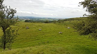
Ninestane Rig is a small stone circle in Scotland near the English border. Located in Roxburghshire, near to Hermitage Castle, it was probably made between 2000 BC and 1250 BC, during the Late Neolithic or early Bronze Age. It is a scheduled monument and is part of a group with two other nearby ancient sites, these being Buck Stone standing stone and another standing stone at Greystone Hill. Settlements appear to have developed in the vicinity of these earlier ritual features in late prehistory and probably earlier.

Easthill stone circle

Easthill stone circle, also known as the Seven Grey Stanes, is a small oval stone circle 3¾ miles south-west of Dumfries. Eight stones of a probable nine remain. Despite being considerably smaller, the shape and orientation of the circle link it to the nearby Twelve Apostles and the other large ovals of Dumfriesshire. It is a scheduled monument.

Loupin Stanes

The Loupin Stanes is a stone circle near Eskdalemuir, Dumfries and Galloway. Oval in shape, it consists of twelve stones set on an artificial platform. At the WSW of the circle are two large pillars, which are typical of the 'entrance circles' of south-west Scotland. The circle takes its name from the tradition of leaping between the tops of these two stones.

Girdle Stanes

The Girdle Stanes is a stone circle near Eskdalemuir, Dumfries and Galloway. The western portion of the circle has been washed away by the White Esk, leaving 26 of an original 40 to 45 stones in a crescent. Unlike the majority of such sites in Dumfriesshire, the Girdle Stanes forms a true circle rather than an oval. When complete, its diameter would have been 39m.

Killin Stone Circle

Killin Stone Circle is a prehistoric stone circle situated at the west end of Loch Tay near the village of Killin, Stirling, Scotland. It is a scheduled monument.

The Goatstones Stone circle in Northumberland, England

The Goatstones is a Bronze-Age four-poster stone circle located near Ravensheugh Crags in Northumberland, England. It is 2.5 miles (4.0 km) to the north of Hadrian's Wall in the parish of Wark-on-Tyne. The name is thought to be derived from the Saxon "gyet stanes" meaning "wayside stones". The monument probably had some kind of religious purpose.

Kealkill stone circle Axial five-stone stone circle in County Cork, Ireland

Kealkill stone circle is a bronze age axial five-stone circle located just outside the village of Kealkill, County Cork in southwest Ireland. When it was excavated in 1938 it was thought the crucial axial stone indicated an alignment to the north, contrary to the general alignment of such stone circles to the southwest. However, later archaeologists have thought it is the comparatively insignificant stone to the southwest that is the axial stone. There are two associated standing stones nearby, one of which had fallen and was re-erected in 1938.

Loanhead of Daviot stone circle Recumbent stone circle in Aberdeenshire

Loanhead of Daviot stone circle is a recumbent stone circle in Aberdeenshire in lowland northeast Scotland. The circle consists of the recumbent stone with its flankers and a complete set of eight orthostats about 21 metres (69 ft) in diameter surrounding a low kerbed ring cairn which has an open court. However, the present appearance has in part been produced by substantial restoration after archaeological excavation in 1934, and in 1989 by the removal of the stones covering the central court.

Dunnideer stone circle

Dunnideer stone circle is a mostly destroyed recumbent stone circle located near Insch in Aberdeenshire, Scotland. The three remaining stones lie close to the ruins of Dunnideer Castle. It is a scheduled monument.

Tyrebagger stone circle Stone circle in Aberdeen, Scotland

Tyrebagger stone circle is located at Dyce, near to Aberdeen in Scotland. It is a complete recumbent stone circle. It was used as a cattle pound in the past and now stands close to the Aberdeen Western Peripheral Route. It is a scheduled monument since 1925.

References

  1. "Canmore Advanced Search: Stone Circle: Scottish Borders" . Retrieved 31 December 2014.
  2. Burl, Aubrey (2000). The Stone Circles of Britain, Ireland and Brittany . New Haven; London: Yale University Press. pp.  394. The Stone Circles of Britain, Ireland and Brittany.
  3. "Borrowston Rig | Canmore". canmore.org.uk. Retrieved 11 July 2015.
  4. "Burgh Hill | Canmore". canmore.org.uk. Retrieved 11 July 2015.
  5. "Cloyhouse Burn | Canmore". canmore.org.uk. Retrieved 11 July 2015.
  6. "Five Stanes | Canmore". canmore.org.uk. Retrieved 11 July 2015.
  7. "Five Stone Field | Canmore". canmore.org.uk. Retrieved 11 July 2015.
  8. "Harelaw, Fairnington | Canmore". canmore.org.uk. Retrieved 11 July 2015.
  9. "Harestanes | Canmore". canmore.org.uk. Retrieved 11 July 2015.
  10. "Harestanes Cottages | Canmore". canmore.org.uk. Retrieved 11 July 2015.
  11. "Kirktonhill | Canmore". canmore.org.uk. Retrieved 11 July 2015.
  12. "Megget Reservoir | Canmore". canmore.org.uk. Retrieved 11 July 2015.
  13. "Ninestone Rig | Canmore". canmore.org.uk. Retrieved 11 July 2015.
  14. "Oxnam Parish | Canmore". canmore.org.uk. Retrieved 11 July 2015.
  15. "Plenderleith | Canmore". canmore.org.uk. Retrieved 11 July 2015.
  16. "Redden | Canmore". canmore.org.uk. Retrieved 11 July 2015.
  17. "Stobo Mill | Canmore". canmore.org.uk. Retrieved 11 July 2015.
  18. "Yadlee | Canmore". canmore.org.uk. Retrieved 11 July 2015.