List of stone circles in Dumfries and Galloway

Last updated

Dumfries and Galloway UK location map.svg
Red pog.svg
1
Red pog.svg
2
Red pog.svg
3
Red pog.svg
4
Red pog.svg
5
Red pog.svg
6
Red pog.svg
7
Red pog.svg
8
Red pog.svg
9
Red pog.svg
10
Red pog.svg
11
Locations of well-preserved stone circles in Dumfries and Galloway. 1.  Cauldside Burn 2.  Claughreid 3.  Easthill 4.  Girdle Stanes 5  Glenquicken 6.  Loupin Stanes 7.  Seven Brethren 8.  Standing Stones of Glenterrow 9.  Torhouskie 10.  Twelve Apostles 11.  Whitcastles
Map all coordinates using: OpenStreetMap  
Download coordinates as: KML

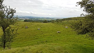
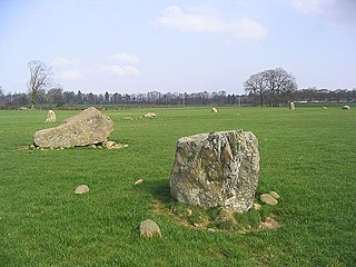
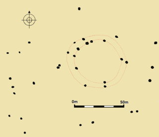
This is a list of stone circles located in the Dumfries and Galloway council area. It is compiled from Aubrey Burl's 'County Gazetteer of the Stone Circles in Britain, Ireland and Brittany' [1] and the Royal Commission on the Ancient and Historical Monuments of Scotland's 'Canmore' database. [2] Between them, these two sources list 61 stone circles in the region. Many of these have been destroyed, some remains have not been conclusively identified as stone circles, some were dubious before their destruction and some have not been located by modern surveys.

The following sites are the best preserved:

NameImageGrid reference
Coordinates
Former county
Parish
Notes
Airdrie NX 966 587
54°54′46″N3°36′49″W / 54.912725°N 3.613694°W / 54.912725; -3.613694 (Airdrie stone circle)
Kirkcudbrightshire

Kirkbean

A stone circle was recorded in the Old Statistical Account for the parish in 1794 and thirty years later by George Chalmers, but by 1893 the circle could not be found nor was there any local knowledge of the site. [3]
  • RCAHMS classification: Stone circle (possible) [3]
  • Listed in Burl (2000): No
Bagbie NX 4979 5639
54°52′47″N4°20′34″W / 54.879681°N 4.342786°W / 54.879681; -4.342786 (Bagbie stone circle)
Kirkcudbrightshire

Kirkmabreck

  • RCAHMS classification: Four poster stone circle [4]
  • Listed in Burl (2000): Yes [5]
Bombie NX 7079 5018
54°49′47″N4°00′47″W / 54.829781°N 4.01292°W / 54.829781; -4.01292 (Bombie stone circle)
Kirkcudbrightshire

Kirkcudbright

  • RCAHMS classification: Stone circle (possible) [6]
  • Listed in Burl (2000): No
Booth's Burn, Kirkslight Rig NY 2221 8837
55°11′01″N3°13′23″W / 55.183518°N 3.223108°W / 55.183518; -3.223108 (Booth's Burn stone circle)
Dumfriesshire

Hutton and Corrie

  • RCAHMS classification: Cist(s) (possible), stone(s) [7]
  • Listed in Burl (2000): Yes (as Kirkslight Rig) [8]
Branteth NY 28 75
55°04′08″N3°07′16″W / 55.068796°N 3.121181°W / 55.068796; -3.121181 (Branteth stone circle)
Dumfriesshire

Kirkpatrick-Fleming

  • RCAHMS classification: Stone circle (possible) [9]
  • Listed in Burl (2000): No
Broathill NY 26 69
55°00′53″N3°09′03″W / 55.014598°N 3.150946°W / 55.014598; -3.150946 (Broathill stone circle)
Dumfriesshire

Kirkpatrick-Fleming

  • RCAHMS classification: Stone circle [10]
  • Listed in Burl (2000): No
Burntscarth Green Farm NX 9898 8018
55°06′21″N3°35′06″W / 55.105747°N 3.584863°W / 55.105747; -3.584863 (Burntscarth Green stone circle)
Dumfriesshire

Kirkmahoe

  • RCAHMS classification: Stone circle (possible) [11]
  • Listed in Burl (2000): No
Carlin Stone NX 3255 4971
54°48′51″N4°36′26″W / 54.814238°N 4.60734°W / 54.814238; -4.60734 (Carlin Stone)
Wigtownshire

Mochrum

  • RCAHMS classification: Standing stone [12]
  • Listed in Burl (2000): Yes (as Eldrig Loch) [13]
Cauldside Burn NX 5295 5711
54°53′14″N4°17′38″W / 54.887086°N 4.293943°W / 54.887086; -4.293943 (Cauldside Burn stone circle)
Kirkcudbrightshire

Anwoth

  • RCAHMS classification: Stone circle [14]
  • Listed in Burl (2000): Yes [15]
Clachanmore NX 083 467
54°46′44″N4°58′54″W / 54.778958°N 4.981531°W / 54.778958; -4.981531 (Clachanmore stone circle)
Wigtownshire

Stoneykirk

  • RCAHMS classification: Stone circle (possible) [16]
  • Listed in Burl (2000): No
Claughreid NX 5178 5600
54°52′36″N4°18′42″W / 54.876774°N 4.311595°W / 54.876774; -4.311595 (Claughreid stone circle)
Kirkcudbrightshire

Kirkmabreck

  • RCAHMS classification: Stone circle [17]
  • Listed in Burl (2000): Yes [15]
Claywarnies NX 10 71
55°00′07″N4°57′52″W / 55.00189°N 4.96443°W / 55.00189; -4.96443 (Claywarnies stone circle)
Wigtownshire

Inch

  • RCAHMS classification: Stone circle (possible) [18]
  • Listed in Burl (2005):
Drumfern NX 3999 7099
55°00′28″N4°30′13″W / 55.007715°N 4.503519°W / 55.007715; -4.503519 (Drumfern stone circle)
Kirkcudbrightshire

Minnigaff

  • RCAHMS classification: Stone circle [19]
  • Listed in Burl (2000): Yes (as Drandnandow) [15]
Drummore NX 6884 4597
54°47′29″N4°02′29″W / 54.791465°N 4.041347°W / 54.791465; -4.041347 (Drummore stone circle)
Kirkcudbrightshire

Kirkcudbright

  • RCAHMS classification: Stone circle [20]
  • Listed in Burl (2000): Yes [15]
Easthill NX 9193 7388
55°02′52″N3°41′35″W / 55.047673°N 3.692922°W / 55.047673; -3.692922 (Easthill stone circle)
Kirkcudbrightshire

Lochrutton

  • RCAHMS classification: Stone circle [21]
  • Listed in Burl (2000): Yes [22]
Ernespie NX 7747 6321
54°56′55″N3°54′52″W / 54.948487°N 3.91454°W / 54.948487; -3.91454 (Ernespie stone circle)
Kirkcudbrightshire

Kelton

  • RCAHMS classification: Standing stone(s), stone circle (possible) [23]
  • Listed in Burl (2000): Yes [24]
Foregirth Farm NX 95 83
55°08′05″N3°38′26″W / 55.134801°N 3.640683°W / 55.134801; -3.640683 (Foregirth Farm stone circle)
Dumfriesshire

Kirkmahoe

  • RCAHMS classification: Stone circle [25]
  • Listed in Burl (2000): No
Glaisters NX 761 801
55°06′01″N3°56′33″W / 55.100252°N 3.942559°W / 55.100252; -3.942559 (Glaisters stone circle)
Kirkcudbrightshire

Kirkpatrick Durham

  • RCAHMS classification: stone circle (possible) (as Gaisters) [26]
  • Listed in Burl (2000): No
Glenjorrie NX 206 581
54°53′09″N4°47′51″W / 54.885829°N 4.79761°W / 54.885829; -4.79761 (Glenjorrie stone circle)
Wigtownshire

Old Luce

  • RCAHMS classification: Stone circle (possible) [27]
  • Listed in Burl (2000): No
Girdle Stanes The Girdle Stanes stone circle - geograph.org.uk - 819407.jpg NY 2535 9615
55°15′14″N3°10′33″W / 55.253898°N 3.175867°W / 55.253898; -3.175867 (Girdle Stanes)
Dumfriesshire

Eskdalemuir

  • RCAHMS classification: Stone circle [28]
  • Listed in Burl (2000): Yes [29]
Glenquicken Stone Circle south of Old Military Road - geograph.org.uk - 1290115.jpg NX 5096 5821
54°53′51″N4°19′44″W / 54.897385°N 4.328997°W / 54.897385; -4.328997 (Glenquicken stone circle)
Kirkcudbrightshire

Kirkmabreck

  • RCAHMS classification: Stone circle [30]
  • Listed in Burl (2000): Yes (as Glenquickan N) [24]
Glenquicken Moor 1 NX 5079 5830
54°53′50″N4°19′42″W / 54.897131°N 4.328202°W / 54.897131; -4.328202 (Glenquicken Moor 1 stone circle)
Kirkcudbrightshire

Kirkmabreck

  • RCAHMS classification: Stone circle [31]
  • Listed in Burl (2000): Yes (as Glenquickan S) [24]
Glenquicken Moor 2 NX 5074 5833
54°53′51″N4°19′44″W / 54.897385°N 4.328997°W / 54.897385; -4.328997 (Glenquicken Moor 2 stone circle)
Kirkcudbrightshire

Kirkmabreck

  • RCAHMS classification: Stone circle [32]
  • Listed in Burl (2000): No
Glenturk NX 424 579
54°53′29″N4°27′29″W / 54.891381°N 4.458009°W / 54.891381; -4.458009 (Glenturk stone circle)
Wigtownshire

Wigtown

  • RCAHMS classification: Standing stone (possible), stone circle (possible) [33]
  • Listed in Burl (2000): No
Greystone Park NX 9798 7690
55°04′34″N3°35′58″W / 55.07608°N 3.599354°W / 55.07608; -3.599354 (Greystone Park stone circle)
Dumfriesshire

Dumfries

  • RCAHMS classification: Stone circle [34]
  • Listed in Burl (2000): Yes (as Greystone, The) [29]
High Auchenlarie NX 5395 5342
54°51′15″N4°16′35″W / 54.854246°N 4.276497°W / 54.854246; -4.276497 (High Auchenlarie stone circle)
Kirkcudbrightshire

Anwoth

  • RCAHMS classification: Cairn, stone setting (possible) [35]
  • Listed in Burl (2000): Yes [24]
Holm of Daltallochan Stone Circle at Holm of Daltallochan - geograph.org.uk - 1280950.jpg NX 5528 9422
55°13′16″N4°16′35″W / 55.220978°N 4.276488°W / 55.220978; -4.276488 (Holm of Daltallochan)
Kirkcudbrightshire

Carsphairn

  • RCAHMS classification: Stone circle (possible) [36]
  • Listed in Burl (2000): Yes [24]
Kirkbean Parish NX 97 59
54°55′11″N3°36′03″W / 54.919637°N 3.600708°W / 54.919637; -3.600708 (Kirkbean Parish stone circle)
Kirkcudbrightshire

Kirkbean

  • RCAHMS classification: Stone circle (possible) [37]
  • Listed in Burl (2000): No
Kirkgunzeon NX 8657 6668
54°58′55″N3°46′26″W / 54.981808°N 3.773912°W / 54.981808; -3.773912 (Kirkgunzeon stone circle)
Kirkcudbrightshire

Kirkgunzeon

  • RCAHMS classification: Stone circle [38]
  • Listed in Burl (2000): Yes [24]
Kirkhill NY 1396 9592
55°15′00″N3°21′18″W / 55.249974°N 3.354933°W / 55.249974; -3.354933 (Kirkhill stone circle)
Dumfriesshire

Wamphray

  • RCAHMS classification: Stone circle (possible) [39]
  • Listed in Burl (2000): Yes [29]
Kirkmadrine NX 0801 4848
54°47′40″N4°59′16″W / 54.794401°N 4.987881°W / 54.794401; -4.987881 (Kirkmadrine stone circle)
Wigtownshire

Stoneykirk

  • RCAHMS classification: Stone circle (possible) [40]
  • Listed in Burl (2000): No
Knockshinnie NX 6822 4517
54°47′03″N4°03′02″W / 54.784118°N 4.05062°W / 54.784118; -4.05062 (Knockshinnie stone circle)
Kirkcudbrightshire

Kirkcudbright

  • RCAHMS classification: Clearance cairn(s), quarry [41]
  • Listed in Burl (2000): Yes [24]
Laggangarn NX 2223 7166
55°00′28″N4°46′53″W / 55.007701°N 4.781301°W / 55.007701; -4.781301 (Laggangarn stone circle)
Wigtownshire
  • RCAHMS classification: Standing stone(s) [42]
  • Listed in Burl (2000): Yes [43]
Little Balmae NX 691 447
54°46′50″N4°02′10″W / 54.780544°N 4.036054°W / 54.780544; -4.036054 (Little Balmae stone circle)
Kirkcudbrightshire

Kirkcudbright

  • RCAHMS classification: Stone circle (possible) [44]
  • Listed in Burl (2000): Yes [24]
Loch Mannoch 1 NX 6628 6143
54°55′47″N4°05′18″W / 54.929626°N 4.088299°W / 54.929626; -4.088299 (Loch Mannoch 1 stone circle)
Kirkcudbrightshire

Tongland

  • RCAHMS classification: Stone circle [45]
  • Listed in Burl (2000): Yes (as Lairdmannoch) [24]
Loch Mannoch 2 NX 663 615
54°55′50″N4°05′14″W / 54.930676°N 4.087339°W / 54.930676; -4.087339 (Loch Mannoch 2 stone circle)
Kirkcudbrightshire

Tongland

  • RCAHMS classification: Stone circle (possible) [46]
  • Listed in Burl (2000): No
Lochmaben Stane The Lochmaben Stone - geograph.org.uk - 1055490.jpg NY 3123 6600
54°59′02″N3°04′34″W / 54.983875°N 3.076073°W / 54.983875; -3.076073 (Lochmaben Stane)
Dumfriesshire

Gretna

  • RCAHMS classification: Standing stone(s) [47]
  • Listed in Burl (2000): Yes [29]
Longcastle NX 3824 4810
54°48′06″N4°31′05″W / 54.801653°N 4.517989°W / 54.801653; -4.517989 (Longcastle stone circle)
Wigtownshire

Kirkinner

  • RCAHMS classification: Standing stone [48]
  • Listed in Burl (2000): Yes [43]
Loupin Stanes 1 The Loupin' Stanes stone circle - geograph.org.uk - 811307.jpg NY 2570 9663
55°15′30″N3°10′14″W / 55.258263°N 3.170489°W / 55.258263; -3.170489 (Loupin Stanes)
Dumfriesshire

Eskdalemuir

  • RCAHMS classification: Stone circle [49]
  • Listed in Burl (2000): Yes (as Loupin' Stanes Centre) [50]
Loupin Stanes 2 NY 256 966
55°15′30″N3°10′17″W / 55.258389°N 3.171358°W / 55.258389; -3.171358 (Loupin Stanes 2 stone circle)
Dumfriesshire

Eskdalemuir

  • RCAHMS classification: Not listed
  • Listed in Burl (2000): Yes (as Loupin' Stanes NW) [50]
Loupin Stanes 3 NY 258 965
55°15′27″N3°10′05″W / 55.257521°N 3.168186°W / 55.257521; -3.168186 (Loupin Stanes 3 stone circle)
Dumfriesshire

Eskdalemuir

  • RCAHMS classification: Not listed
  • Listed in Burl (2000): Yes (as Loupin' Stanes SE) [50]
Mains of Southwick NX 93 57
54°54′03″N3°39′44″W / 54.900834°N 3.662346°W / 54.900834; -3.662346 (Mains of Southwick stone circle)
Kirkcudbrightshire

Colvend and Southwick

  • RCAHMS classification: Stone circle (possible) [51]
  • Listed in Burl (2000): No
Miltonise NX 1925 7405
55°01′41″N4°49′46″W / 55.028078°N 4.829349°W / 55.028078; -4.829349 (Miltonise stone circle)
Wigtownshire

New Luce

  • RCAHMS classification: Cairn(s) [52]
  • Listed in Burl (2000): Yes (as Miltonish) [43]
Morton Old Church NX 8902 9696
55°15′16″N3°44′51″W / 55.25433°N 3.747485°W / 55.25433; -3.747485 (Morton Old Church stone circle)
Dumfriesshire

Morton

  • RCAHMS classification: Stone circle (possible) [53]
  • Listed in Burl (2000): No
Newlands NX 96 85
55°09′11″N3°37′33″W / 55.152976°N 3.625735°W / 55.152976; -3.625735 (Newlands stone circle)
Dumfriesshire

Kirkmahoe

  • RCAHMS classification: Stone circle (possible) [54]
  • Listed in Burl (2000): No
Park, Tongland Park of Tongland Standing Stones.jpg NX 6996 5609
54°52′58″N4°01′43″W / 54.882642°N 4.028495°W / 54.882642; -4.028495 (Park of Tongland stone circle)
Kirkcudbrightshire

Tongland

  • RCAHMS classification: Kerb cairn [55]
  • Listed in Burl (2000): Yes (as Park of Tongland) [24]
Queen Mary's Bridge NX 7030 5476
54°52′15″N4°01′21″W / 54.870786°N 4.022601°W / 54.870786; -4.022601 (Queen Mary's Bridge stone circle)
Kirkcudbrightshire

Tongland

  • RCAHMS classification: Stone circle [56]
  • Listed in Burl (2000): No
Seven Brethren NY 2171 8269
55°07′57″N3°13′46″W / 55.132411°N 3.229387°W / 55.132411; -3.229387 (Seven Brethren stone circle)
Dumfrieshire

Tundergarth

  • RCAHMS classification: Stone circle [57]
  • Listed in Burl (2000): Yes (as Whiteholm Rigg) [29]
Shore Plantation NX 6750 4636
54°47′41″N4°03′44″W / 54.794615°N 4.062352°W / 54.794615; -4.062352 (Shore Plantation stone circle)
Kirkcudbrightshire

Kirkcudbright

  • RCAHMS classification: Stone circle (possible) [58]
  • Listed in Burl (2000): No
Standing Stones of Balmennoch NX 06 57
54°52′29″N5°01′03″W / 54.874719°N 5.017445°W / 54.874719; -5.017445 (Standing stones of Balmennoch)
Wigtownshire

Inch

  • RCAHMS classification: Stone circle [59]
  • Listed in Burl (2000): Yes (as Balmannoch) [60]
Standing Stones of Glenterrow The Standing Stones of Glenterrow - geograph.org.uk - 586547.jpg NX 1453 6251
54°55′22″N4°53′44″W / 54.922772°N 4.895622°W / 54.922772; -4.895622 (Standing Stones of Glenterrow)
Wigtownshire

Inch

  • RCAHMS classification: Stone circle [61]
  • Listed in Burl (2000): Yes (as Glentirrow) [43]
Steeps Park NX 248 531
54°50′33″N4°43′45″W / 54.842437°N 4.72918°W / 54.842437; -4.72918 (Steeps Park stone circle)
Wigtownshire

Old Luce

  • RCAHMS classification: Stone circle (possible) [62]
  • Listed in Burl (2000): Yes [43]
Stroan Loch NX 640 709
55°00′52″N4°07′40″W / 55.014467°N 4.127666°W / 55.014467; -4.127666 (Stroan Loch stone circle)
Kirkcudbrightshire

Kells

  • RCAHMS classification: Stone circle [63]
  • Listed in Burl (2000): Yes (as Loch Stroan) [24]
Strongassel NX 5923 8684
55°09′21″N4°12′39″W / 55.155854°N 4.210771°W / 55.155854; -4.210771 (Strongassel stone circle)
Kirkcudbrightshire

Kells

  • RCAHMS classification: Clearance cairn(s) [64]
  • Listed in Burl (2000): Yes (as Stroangassel) [24]
Templand Mains NX 8771 9396
55°13′38″N3°46′01″W / 55.227089°N 3.766889°W / 55.227089; -3.766889 (Templand Mains stone circle)
Dumfriesshire

Closeburn

  • RCAHMS classification: Standing stone [65]
  • Listed in Burl (2000): Yes (as Kirkbog) [29]
The Thieves NX 4044 7159
55°00′48″N4°29′49″W / 55.013246°N 4.496825°W / 55.013246; -4.496825 (The Thieves)
Kirkcudbrightshire

Minnigaff

  • RCAHMS classification: Standing stone(s) [66]
  • Listed in Burl (2000): Yes [24]
Three Piked Stane NY 2170 6787
54°59′57″N3°13′32″W / 54.999266°N 3.225467°W / 54.999266; -3.225467 (Three Piked Stane)
Dumfriesshire

Annan

  • RCAHMS classification: Stone circle (possible) [67]
  • Listed in Burl (2000): Yes (as Woodhead) [29]
Torhouskie 1 Torhouse Stone Circle 20080423.jpg NX 3825 5649
54°52′37″N4°31′21″W / 54.876979°N 4.52253°W / 54.876979; -4.52253 (Torhouskie stone circle)
Wigtownshire

Wigtown

  • RCAHMS classification: Stone circle [68]
  • Listed in Burl (2000): Yes (as Torhouskie E) [43]
Torhouskie 2 NX 3820 5644
54°52′35″N4°31′24″W / 54.876514°N 4.52328°W / 54.876514; -4.52328 (Torhouskie 2)
Wigtownshire

Wigtown

  • RCAHMS classification: Standing stone(s) [69]
  • Listed in Burl (2000): Yes (as Torhouskie W) [43]
Twelve Apostles Twelve Apostles Stone Circle - geograph.org.uk - 385556.jpg NX 9470 7940
55°05′52″N3°39′06″W / 55.09785°N 3.651629°W / 55.09785; -3.651629 (Twelve Apostles stone circle)
Dumfriesshire

Holywood

  • RCAHMS classification: Stone circle [70]
  • Listed in Burl (2000): Yes [29]
Wallace's Putting Stone NX 7016 4381
54°46′21″N4°01′12″W / 54.77241°N 4.019865°W / 54.77241; -4.019865 (Wallace's Putting Stone)
Kirkcudbrightshire

Kirkcudbright

  • RCAHMS classification: Stone circle (possible) [71]
  • Listed in Burl (2000): No
Westerkirk Mains NY 29 91
55°12′46″N3°06′34″W / 55.212687°N 3.109507°W / 55.212687; -3.109507 (Westerkirk Mains stone circle)
Dumfriesshire

Westerkirk

  • RCAHMS classification: Stone circle (possible) [72]
  • Listed in Burl (2000): Yes (as Westerkirk) [29]
Whitcastles Whitcastles Stone Circle - geograph.org.uk - 2165337.jpg NY 2240 8806
55°10′51″N3°13′12″W / 55.180763°N 3.220039°W / 55.180763; -3.220039 (Whitcastles stone circle)
Dumfriesshire

Hutton and Corrie

  • RCAHMS classification: Stone circle [73]
  • Listed in Burl (2005):
Windy Edge NY 4304 8389
55°08′46″N2°53′42″W / 55.146108°N 2.895135°W / 55.146108; -2.895135 (Windy Edge)
Dumfriesshire

Canonbie

  • RCAHMS classification: Cairn (possible), standing stone(s) [74]
  • Listed in Burl (2000): Yes [29]

See also

Related Research Articles

Stone circle Ring of standing stones

A stone circle is a ring of standing stones. Most are found in Northwestern Europe—especially in Britain, Ireland and Brittany—and typically date from the Late Neolithic and Early Bronze Age, with most being built from 3000 BC. The best known examples include those at the henge monument at Avebury, the Rollright Stones, and elements within the ring of standing stones at Stonehenge. There are scattered examples from other parts of Europe. Later, during the Iron Age, stone circles were built in southern Scandinavia.

Harry Aubrey Woodruff Burl HonFSA Scot was a British archaeologist best known for his studies into megalithic monuments and the nature of prehistoric rituals associated with them. Before retirement he was Principal Lecturer in Archaeology, Hull College, East Riding of Yorkshire. Burl received a volume edited in his honour. He was called by The New York Times, "the leading authority on British stone circles".

The Sanctuary Prehistoric site in Wiltshire, England

The Sanctuary was a stone and timber circle near the village of Avebury in the south-western English county of Wiltshire. Excavation has revealed the location of the 58 stone sockets and 62 post-holes. The ring was part of a tradition of stone circle construction that spread throughout much of Britain, Ireland, and Brittany during the Late Neolithic and Early Bronze Age, over a period between 3300 and 900 BCE. The purpose of such monuments is unknown, although archaeologists speculate that the stones represented supernatural entities for the circle's builders.

Swinside

Swinside, which is also known as Sunkenkirk and Swineshead, is a stone circle lying beside Swinside Fell, part of Black Combe in southern Cumbria, North West England. One of around 1,300 recorded stone circles in the British Isles and Brittany, it was constructed as a part of a megalithic tradition that lasted from 3,300 to 900 BC, during what archaeologists categorise as the Late Neolithic and Early Bronze Ages.

Twelve Apostles Stone Circle Stone circle in Dumfries and Galloway, Scotland

The Twelve Apostles is a large stone circle located between the villages of Holywood and Newbridge, near Dumfries, Scotland. It is the seventh largest stone circle in Britain and the largest on the mainland of Scotland. It is similar in design to the stone circles of Cumbria, and is considered to be an outlier of this group. Its south-westerly arrangement aligns it with the midwinder sunset.

Stone circles in the British Isles and Brittany Megalithic tradition of monuments

The stone circles in the British Isles and Brittany are a megalithic tradition of monuments consisting of standing stones arranged in rings. These were constructed from 3300 to 900 BCE in Britain, Ireland and Brittany. It has been estimated that around 4,000 of these monuments were originally constructed in this part of north-western Europe during this period. Around 1,300 of them are recorded, the others having been destroyed.

Nine Stones Close Bronze age stone circle in England

Nine Stones Close, also known as the Grey Ladies, is a Bronze Age stone circle located near Youlgreave in Derbyshire. It sits within a local prehistoric landscape that includes Bronze Age barrows and settlement enclosures, and is part of a tradition of stone circle construction that spread throughout much of Britain, Ireland, and Brittany during the Late Neolithic and Early Bronze Ages, over a period between 3300 and 900 BCE. The purpose of the monument is unknown, although archaeologists have speculated that the stones represented supernatural entities.

Easthill stone circle

Easthill stone circle, also known as the Seven Grey Stanes, is a small oval stone circle 3¾ miles south-west of Dumfries. Eight stones of a probable nine remain. Despite being considerably smaller, the shape and orientation of the circle link it to the nearby Twelve Apostles and the other large ovals of Dumfriesshire. It is a scheduled monument.

Loupin Stanes

The Loupin Stanes is a stone circle near Eskdalemuir, Dumfries and Galloway. Oval in shape, it consists of twelve stones set on an artificial platform. At the WSW of the circle are two large pillars, which are typical of the 'entrance circles' of south-west Scotland. The circle takes its name from the tradition of leaping between the tops of these two stones.

Glenquicken stone circle

Glenquicken stone circle or Billy Diamond's Bridge stone circle is an oval stone circle with a central pillar, two miles east of Creetown, Dumfries and Galloway. The outer ring is formed of 29 stones. Aubrey Burl has called it "the finest of all centre-stone circles." It is a scheduled monument.

Girdle Stanes

The Girdle Stanes is a stone circle near Eskdalemuir, Dumfries and Galloway. The western portion of the circle has been washed away by the White Esk, leaving 26 of an original 40 to 45 stones in a crescent. Unlike the majority of such sites in Dumfriesshire, the Girdle Stanes forms a true circle rather than an oval. When complete, its diameter would have been 39m.

Whitcastles stone circle Stone circle in Dumfries and Galloway, Scotland

Whitcastles or Little Hartfell is a stone circle 6½ miles NE of Lockerbie, Dumfries and Galloway. Nine fallen stones lie in an oval measuring 55m by 45m. The largest stones lie to the north and south of the circle; interest in cardinal points is a common feature in the stone circles of the Solway Firth. It was designated as a scheduled monument in 1937.

Holywood, Dumfries and Galloway Human settlement in Scotland

Holywood is a village and civil parish in the historical county of Dumfriesshire in Dumfries and Galloway, Scotland. The village of Holywood was developed in the mid twentieth century. In 1949 eighteen houses were built by the county council and followed shortly after by another 38.

Bocan Stone Circle

Bocan Stone Circle is a stone circle situated near the village of Culdaff in County Donegal, in the Republic of Ireland.

Fir Clump Stone Circle Neolithic stone circle in Wiltshire, England

Fir Clump Stone Circle was a stone circle in Burderop Wood near Wroughton, Wiltshire, in South West England. The ring was part of a tradition of stone circle construction that spread throughout much of Britain, Ireland, and Brittany during the Late Neolithic and Early Bronze Age, over a period between 3300 and 900 BCE. The purpose of such monuments is unknown, although some archaeologists speculate that the stones represented supernatural entities for the circle's builders.

Broome Stone Circle was a stone circle located in the south-western English county of Wiltshire. The ring was part of a tradition of stone circle construction that spread throughout much of Britain, Ireland, and Brittany during the Late Neolithic and Early Bronze Age, over a period between 3300 and 900 BCE. The purpose of such monuments is unknown, although archaeologists speculate that the stones represented supernatural entities for the circle's builders.

Dunnideer stone circle

Dunnideer stone circle is a mostly destroyed recumbent stone circle located near Insch in Aberdeenshire, Scotland. The three remaining stones lie close to the ruins of Dunnideer Castle. It is a scheduled monument.

References

  1. Burl, Aubrey (2000). "County Gazetteer of the Stone Circles in Britain, Ireland and Brittany". The stone circles of Britain, Ireland and Brittany. New Haven and London: Yale University Press. pp.  393–437. ISBN   0300083475.
  2. "Canmore Advanced Search: Stone Circle: Dumfries and Galloway" . Retrieved 31 December 2014.
  3. 1 2 "Airdrie | Canmore". canmore.org.uk. Archived from the original on 4 July 2015. Retrieved 30 May 2015.
  4. "Bagbie | Canmore". canmore.org.uk. Archived from the original on 4 July 2015. Retrieved 30 May 2015.
  5. Burl, Aubrey (2000). The stone circles of Britain, Ireland and Brittany. New Haven and London: Yale University Press. pp.  429. ISBN   0300083475.
  6. "Bombie | Canmore". canmore.org.uk. Archived from the original on 4 July 2015. Retrieved 4 July 2015.
  7. "Booth's Burn, Kirkslight Rig | Canmore". canmore.org.uk. Archived from the original on 4 July 2015. Retrieved 4 July 2015.
  8. Burl, Aubrey (2000). The stone circles of Britain, Ireland and Brittany. New Haven and London: Yale University Press. pp.  426. ISBN   0300083475.
  9. "Branteth | Canmore". canmore.org.uk. Archived from the original on 4 July 2015. Retrieved 4 July 2015.
  10. "Broathill | Canmore". canmore.org.uk. Archived from the original on 4 July 2015. Retrieved 4 July 2015.
  11. "Burntscarth Green Farm | Canmore". canmore.org.uk. Archived from the original on 4 July 2015. Retrieved 4 July 2015.
  12. "Carlin Stone | Canmore". canmore.org.uk. Archived from the original on 4 July 2015. Retrieved 4 July 2015.
  13. Burl, Aubrey (2000). The stone circles of Britain, Ireland and Brittany. New Haven and London: Yale University Press. pp.  435. ISBN   0300083475.
  14. "Cauldside Burn | Canmore". canmore.org.uk. Archived from the original on 4 July 2015. Retrieved 4 July 2015.
  15. 1 2 3 4 Burl, Aubrey (2000). The Stone Circles of Britain, Ireland and Brittany . New Haven and London: Yale University Press. pp.  197. caras.
  16. "Clachanmore | Canmore". canmore.org.uk. Retrieved 4 July 2015.
  17. "Claughreid | Canmore". canmore.org.uk. Retrieved 4 July 2015.
  18. "Claywarnies | Canmore". canmore.org.uk. Retrieved 4 July 2015.
  19. "Drumfern | Canmore". canmore.org.uk. Retrieved 4 July 2015.
  20. "Drummore | Canmore". canmore.org.uk. Retrieved 4 July 2015.
  21. "Easthill | Canmore". canmore.org.uk. Retrieved 4 July 2015.
  22. Burl, Aubrey (2000). The stone circles of Britain, Ireland and Brittany . New Haven and London: Yale University Press. pp.  430. aubrey burl stone circles.
  23. "Ernespie | Canmore". canmore.org.uk. Retrieved 4 July 2015.
  24. 1 2 3 4 5 6 7 8 9 10 11 12 13 Burl, Aubrey (2000). The Stone Circles of Britain, Ireland and Brittany . New Haven; London: Yale University Press. pp.  6. easthill stone circle.
  25. "Foregirth Farm | Canmore". canmore.org.uk. Retrieved 4 July 2015.
  26. "Gaisters | Canmore". canmore.org.uk. Retrieved 4 July 2015.
  27. "Glenjorrie | Canmore". canmore.org.uk. Retrieved 4 July 2015.
  28. "Cote, 'girdle Stanes' | Canmore". canmore.org.uk. Retrieved 4 July 2015.
  29. 1 2 3 4 5 6 7 8 9 10 Burl, Aubrey (2000). The Stone Circles of Britain, Ireland and Brittany. New Haven and London: Yale University Press. p. 194.
  30. "Glenquicken | Canmore". canmore.org.uk. Retrieved 4 July 2015.
  31. "Glenquicken Moor | Canmore". canmore.org.uk. Retrieved 4 July 2015.
  32. "Glenquicken Moor | Canmore". canmore.org.uk. Retrieved 4 July 2015.
  33. "Glenturk | Canmore". canmore.org.uk. Retrieved 4 July 2015.
  34. "Dumfries, Greystone Park | Canmore". canmore.org.uk. Retrieved 4 July 2015.
  35. "High Auchenlarie | Canmore". canmore.org.uk. Retrieved 4 July 2015.
  36. "Holm Of Daltallochan | Canmore". canmore.org.uk. Retrieved 4 July 2015.
  37. "Kirkbean Parish | Canmore". canmore.org.uk. Retrieved 4 July 2015.
  38. "Kirkgunzeon | Canmore". canmore.org.uk. Retrieved 4 July 2015.
  39. "Kirkhill | Canmore". canmore.org.uk. Retrieved 4 July 2015.
  40. "Kirkmadrine | Canmore". canmore.org.uk. Retrieved 4 July 2015.
  41. "Knockshinnie | Canmore". canmore.org.uk. Retrieved 4 July 2015.
  42. "Laggangarn | Canmore". canmore.org.uk. Retrieved 4 July 2015.
  43. 1 2 3 4 5 6 7 Burl, Aubrey (2005). A Guide to the Stone Circles of Britain, Ireland and Brittany. New Haven; London: Yale University Press. p. 142.
  44. "Little Balmae | Canmore". canmore.org.uk. Retrieved 4 July 2015.
  45. "Loch Mannoch | Canmore". canmore.org.uk. Retrieved 4 July 2015.
  46. "Loch Mannoch | Canmore". canmore.org.uk. Retrieved 4 July 2015.
  47. "Lochmaben Stone | Canmore". canmore.org.uk. Retrieved 4 July 2015.
  48. "Longcastle | Canmore". canmore.org.uk. Retrieved 4 July 2015.
  49. "'loupin Stanes', Hartmanor | Canmore". canmore.org.uk. Retrieved 4 July 2015.
  50. 1 2 3 Burl, Aubrey (2000). The Stone Circles of Britain, Ireland and Brittany. New Haven and London: Yale University Press. p. 426.
  51. "Mains Of Southwick | Canmore". canmore.org.uk. Retrieved 4 July 2015.
  52. "Miltonise | Canmore". canmore.org.uk. Retrieved 4 July 2015.
  53. "Morton Old Church | Canmore". canmore.org.uk. Retrieved 4 July 2015.
  54. "Newlands | Canmore". canmore.org.uk. Retrieved 4 July 2015.
  55. "Park, Tongland | Canmore". canmore.org.uk. Retrieved 4 July 2015.
  56. "Queen Mary's Bridge | Canmore". canmore.org.uk. Retrieved 4 July 2015.
  57. "Seven Brethren | Canmore". canmore.org.uk. Retrieved 4 July 2015.
  58. "Shore Plantation | Canmore". canmore.org.uk. Retrieved 4 July 2015.
  59. "Standing Stones Of Balmennoch | Canmore". canmore.org.uk. Retrieved 4 July 2015.
  60. Burl, Aubrey (2005). A Guide to the Stone Circles of Britain, Ireland and Brittany. New Haven; London: Yale University Press. p. 435. ISBN   0300083475.
  61. "Standing Stones Of Glenterrow | Canmore". canmore.org.uk. Retrieved 4 July 2015.
  62. "Steeps Park, High Gillespie | Canmore". canmore.org.uk. Retrieved 4 July 2015.
  63. "Stroan Loch | Canmore". canmore.org.uk. Retrieved 4 July 2015.
  64. "Stroangassel | Canmore". canmore.org.uk. Retrieved 4 July 2015.
  65. "Templand Mains | Canmore". canmore.org.uk. Retrieved 4 July 2015.
  66. "The Thieves | Canmore". canmore.org.uk. Retrieved 4 July 2015.
  67. "Three Piked Stane | Canmore". canmore.org.uk. Retrieved 4 July 2015.
  68. "Torhousekie | Canmore". canmore.org.uk. Retrieved 4 July 2015.
  69. "Torhousekie | Canmore". canmore.org.uk. Retrieved 4 July 2015.
  70. "The Twelve Apostles | Canmore". canmore.org.uk. Retrieved 4 July 2015.
  71. "Wallace's Putting Stone, Raeberry Hill | Canmore". canmore.org.uk. Retrieved 4 July 2015.
  72. "Westerkirk Mains | Canmore". canmore.org.uk. Retrieved 4 July 2015.
  73. "Whitcastles | Canmore". canmore.org.uk. Retrieved 4 July 2015.
  74. "Windy Edge | Canmore". canmore.org.uk. Retrieved 4 July 2015.