
The Holy Island of Lindisfarne, commonly known as either Holy Island or Lindisfarne, is a tidal island off the northeast coast of England, which constitutes the civil parish of Holy Island in Northumberland. Holy Island has a recorded history from the 6th century AD; it was an important centre of Celtic Christianity under Saints Aidan of Lindisfarne, Cuthbert, Eadfrith of Lindisfarne and Eadberht of Lindisfarne. After the Viking invasions and the Norman conquest of England, a priory was reestablished. A small castle was built on the island in 1550.
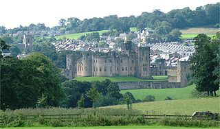
Alnwick is a market town in Northumberland, England, of which it is the traditional county town. The population at the 2011 Census was 8,116.

Corbridge is a village in Northumberland, England, 16 miles (26 km) west of Newcastle and 4 miles (6 km) east of Hexham. Villages nearby include Halton, Acomb, Aydon and Sandhoe.

Rothbury is a town and civil parish in Northumberland, England, on the River Coquet, 13.5 miles (21.7 km) northwest of Morpeth and 26 miles (42 km) of Newcastle upon Tyne. At the 2001 Census, it had a population of 2,107.

Wooler is a small town in Northumberland, England. It lies on the edge of the Northumberland National Park, near the Cheviot Hills. It is a popular base for walkers and is referred to as the "Gateway to the Cheviots". As well as many shops and pubs, the town has a youth hostel, many hotels, and campsites. It lies on the St. Cuthbert's Way long-distance footpath between Melrose Abbey and Lindisfarne.

Morpeth is a historic market town in Northumberland, North East England, lying on the River Wansbeck. Nearby towns include Ashington and Bedlington. In the 2011 census, the population of Morpeth was given as 14,017, up from 13,833 in the 2001 census. The earliest record of the town is believed to be from the Neolithic period. The meaning of the town's name is uncertain, but it may refer to its position on the road to Scotland and a murder which occurred on that road. An alternative origin is a derivation of 'murderers' path' from the time when the gallows were on the Common. The de Marley family was granted the Barony of Morpeth in c. 1080 and built two castles in the town in the late 11th century and the 13th century. The town was granted its coat of arms in 1552. By the mid 1700s it had become one of the main markets in England, having been granted a market charter in 1199, but the opening of the railways in the 1800s led the market to decline. The town's history is celebrated in the annual Northumbrian Gathering.
Berwick-upon-Tweed was a local government district and borough in Northumberland in the north-east of England, on the border with Scotland. The district had a resident population of 25,949 according to the 2001 census, which also notes that it is the most ethnically homogeneous in the country, with 99.6% of the population recording themselves in the 2001 census as White. It was also the smallest district in England with borough status, and the third-least densely populated local government district.

Allendale, often marked on maps as Allendale Town, is a village and civil parish in south west Northumberland, England. At the 2001 census, the parish had a population of 2,120, decreasing to 2,021 at the 2011 Census. Allendale is within the North Pennines Area of Outstanding Natural Beauty (AONB); the second largest of the 40 AONB's in England and Wales. The local economy is predominantly based on agriculture and tourism, although of late it has become a popular commuter town for Newcastle upon Tyne.

Eggleston is a village in County Durham, in England. The population of the civil parish taken at the 2011 Census was 448. It is situated in Teesdale, a few miles north-west of Barnard Castle.

Hartburn is a village in Northumberland, in England. It is situated about 6 miles (10 km) to the west of Morpeth. The population as of the 2011 census was 194.

Matfen is a village and a civil parish in Northumberland, England, near the town of Hexham and the city of Newcastle upon Tyne. It is an example of a 19th-century planned estate village. It was the birthplace of the 7th Premier of British Columbia, William Smithe.

Horton is a village on the Cotswold Edge, in Gloucestershire, England. It is about 2 1⁄2 miles (4.0 km) north of Chipping Sodbury. The nearest settlement is Little Sodbury, about 1 1⁄2 miles (2.4 km) away; Hawkesbury Upton and Dunkirk are both 2 1⁄2 miles (4.0 km) miles away. It is a linear settlement built on the slopes of a steep hill.

Aldbrough St John is a village and civil parish in the Richmondshire district in North Yorkshire, England. The parish has a population of 325, increasing to 392 at the 2011 Census.
St Blazey is a small town in Cornwall, England, United Kingdom.

Akeld was a stone built railway station serving the hamlet of Akeld in Northumberland, England. It was on the Alnwick to Cornhill Branch which ran from Alnwick to Cornhill Junction on the Kelso line near Coldstream.
Mindrum railway station was a stone built railway station serving the hamlet of Mindrum and the surrounding villages in Northumberland. It was on the Alnwick to Cornhill Branch which ran from Alnwick to Cornhill Junction on the Kelso line near Coldstream.
Coldstream railway station served the town of Coldstream in Berwickshire, Scotland although the station was across the River Tweed in Northumberland, England. The station was on both the Alnwick to Cornhill Branch which ran from Alnwick to Cornhill Junction on the Kelso line near Coldstream and the Kelso to Tweedmouth line.

Kilham is a hamlet and civil parish in the English county of Northumberland, located 8.0 miles (12.9 km) west of Wooler, 12.0 miles (19.3 km) east of Kelso, 17.0 miles (27.4 km) south west of Berwick upon Tweed and 38.9 miles (62.6 km) north west of Morpeth. It lies on the northern edge of the Northumberland National Park in Glendale. The hamlet, which consists of a small group of agricultural dwellings, is overlooked by Kilham Hill and the northern limits of the Cheviot Hills. The parish had a population of 131 in 2001, and includes the hamlets of Howtel and Pawston, along with the former upland township of Coldsmouth and Thompson's Walls. falling to less than 100 at the 2011 Census. Details are now included in the parish of Branxton

Ilderton railway station served the village of Ilderton, Northumberland, England from 1887 to 1953 on the Cornhill Branch.

