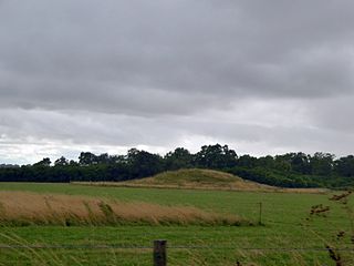
Long Bredy bank barrow on Martin's Down, Dorset, U.K.
A bank barrow, sometimes referred to as a barrow-bank, ridge barrow, or ridge mound, is a type of tumulus first identified by O.G.S. Crawford in 1938.
In the United Kingdom, these take the form of a long, sinuous, parallel-sided mound, approximately uniform in height and width along its length, and usually flanked by ditches on either side. They may be the result of a single phase of construction, or be the result of the addition of one or more linear extensions to the bank of a pre-existing barrow. Although burials have been found within the mound, no burial chambers as such have been identified in bank barrows. These ancient monuments are of middle Neolithic date.
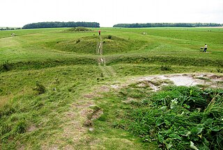
A possible bank barrow near Pentridge in Dorset, U.K. The barrow comprises two distinct parts: the taller narrower part (tree-covered) to the north-east and the wider flatter part (grass-covered) to the south-west. These parts are 50m and 90m long, respectively. Although they have been considered to be two cojoined long barrows, probing and aerial photography has revealed them to have a common continuous ditch (now ploughed out). Another suggestion is that the western part is a classic long barrow, with the eastern part as a tail that was added later.A view along the 180 metre-long Broadmayne bank barrow in Dorset, U.K.
Fewer than ten bank barrows remain in the United Kingdom. Examples may be found at
Ashbee, Paul (1984). The Earthen Long Barrow in Britain: An Introduction to the Study of the Funerary Practice and Culture of the Neolithic People of the Third Millennium B.C. Geo Books. ISBN0-86094-170-1.
Sharples, Niall M (1991). English Heritage Book of Maiden Castle. B. T. Batsford Ltd. ISBN0-7134-6083-0.
Maiden Castle is an Iron Age hillfort 1.6 mi (2.6 km) southwest of Dorchester, in the English county of Dorset. Hill forts were fortified hill-top settlements constructed across Britain during the Iron Age.
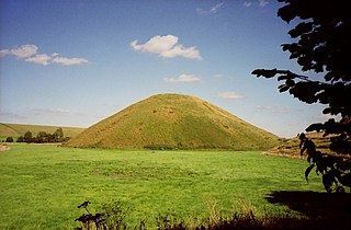
Silbury Hill is a prehistoric artificial chalk mound near Avebury in the English county of Wiltshire. It is part of the Stonehenge, Avebury and Associated Sites UNESCO World Heritage Site. At 39.3 metres (129 ft) high, it is the tallest prehistoric human-made mound in Europe and one of the largest in the world; similar in volume to contemporary Egyptian pyramids.
Rathcroghan is a complex of archaeological sites near Tulsk in County Roscommon, Ireland. It is identified as the site of Cruachan, the traditional capital of the Connachta, the prehistoric and early historic rulers of the western territory. The Rathcroghan Complex is a unique archaeological landscape with many references found in early Irish medieval manuscripts.
A tumulus is a mound of earth and stones raised over a grave or graves. Tumuli are also known as barrows, burial mounds or kurgans, and may be found throughout much of the world. A cairn, which is a mound of stones built for various purposes, may also originally have been a tumulus.
Uffington Castle is an early Iron Age univallate hillfort in Oxfordshire, England. It covers about 32,000 square metres and is surrounded by two earth banks separated by a ditch with an entrance in the western end. A second entrance in the eastern end was apparently blocked up a few centuries after it was built. The original defensive ditch was V-shaped with a small box rampart in front and a larger one behind it. Timber posts stood on the ramparts. Later the ditch was deepened and the extra material dumped on top of the ramparts to increase their size. A parapet wall of sarsen stones lined the top of the innermost rampart. It is very close to the Uffington White Horse on White Horse Hill.
Long barrows are a style of monument constructed across Western Europe in the fifth and fourth millennia BCE, during the Early Neolithic period. Typically constructed from earth and either timber or stone, those using the latter material represent the oldest widespread tradition of stone construction in the world. Around 40,000 long barrows survive today.
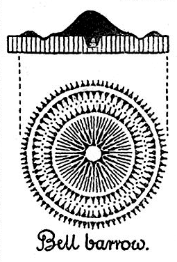
A bell barrow, sometimes referred to as a Wessex type barrow, campanulate form barrow, or a bermed barrow, is a type of tumulus identified as such by both John Aubrey and William Stukeley.
Julliberrie's Grave, also known as The Giant's Grave or The Grave, is an unchambered long barrow located near to the village of Chilham in the south-eastern English county of Kent. Probably constructed in the fourth millennium BCE, during Britain's Early Neolithic period, today it survives only in a state of ruin.
Belas Knap is a neolithic, chambered long barrow situated on Cleeve Hill, near Cheltenham and Winchcombe, in Gloucestershire, England. It is a scheduled ancient monument in the care of English Heritage but managed by Gloucestershire County Council. "Belas" is possibly derived from the Latin word bellus, 'beautiful', which could describe the hill or its view. "Knap" is derived from the Old English for the top, crest, or summit of a hill.
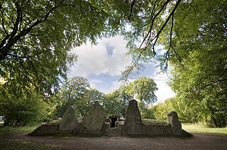
The Stoney Littleton Long Barrow is a Neolithic chambered tomb with multiple burial chambers, located near the village of Wellow in the English county of Somerset. It is an example of the Cotswold-Severn Group and was scheduled as an ancient monument in 1882. It was one of the initial monuments included when the Ancient Monuments Protection Act 1882 became law.
Priddy Circles are a linear arrangement of four circular earthwork enclosures near the village of Priddy on the Mendip Hills in Somerset, England. The circles have been listed as Scheduled Ancient Monuments, and described as 'probable Neolithic ritual or ceremonial monuments similar to a henge'.
In archaeology, earthworks are artificial changes in land level, typically made from piles of artificially placed or sculpted rocks and soil. Earthworks can themselves be archaeological features, or they can show features beneath the surface.
Normanton Down is a Neolithic and Bronze Age barrow cemetery, about 0.6 miles (1 km) south of Stonehenge in Wiltshire, England. The burials date from between 2600 and 1600 BC and consist of a Neolithic long barrow and some 40 or more Bronze Age round barrows, along the crest of a low ridge.
The Cursus Barrows is the name given to a Neolithic and Bronze Age round barrow cemetery lying mostly south of the western end of the Stonehenge Cursus, in Wiltshire, England. The cemetery contains around 18 barrows scattered along an east-to-west ridge, although some of the mounds are no longer visible. The Cursus Barrows can be seen just north of the route between the Stonehenge Visitor Centre and Stonehenge.
51.71025°N 2.29970°W
The architecture of Scotland in the prehistoric era includes all human building within the modern borders of Scotland, before the arrival of the Romans in Britain in the first century BCE. Stone Age settlers began to build in wood in what is now Scotland from at least 8,000 years ago. The first permanent houses of stone were constructed around 6,000 years ago, as at Knap of Howar, Orkney and settlements like Skara Brae. There are also large numbers of chambered tombs and cairns from this era, particularly in the west and north. In the south and east there are earthen barrows, often linked to timber monuments of which only remnants remain. Related structures include bank barrows, cursus monuments, mortuary enclosures and timber halls. From the Bronze Age there are fewer new buildings, but there is evidence of crannogs, roundhouses built on artificial islands and of Clava cairns and the first hillforts. From the Iron Age there is evidence of substantial stone Atlantic roundhouses, which include broch towers, smaller duns. There is also evidence of about 1,000 hillforts in Scotland, most located below the Clyde-Forth line.
Knap Hill lies on the northern rim of the Vale of Pewsey, in northern Wiltshire, England, about a mile north of the village of Alton Priors. At the top of the hill is a causewayed enclosure, a form of Neolithic earthwork that was constructed in England from about 3700 BC onwards, characterized by the full or partial enclosure of an area with ditches that are interrupted by gaps, or causeways. Their purpose is not known: they may have been settlements, or meeting places, or ritual sites of some kind. The site has been scheduled as an ancient monument.
The Grey Mare and her Colts is a megalithic chambered long barrow located near Abbotsbury in Dorset, England. It was built during the Early and Middle Neolithic periods. The tomb was partially excavated in the early nineteenth century, and was found to contain human bones and several pottery fragments.
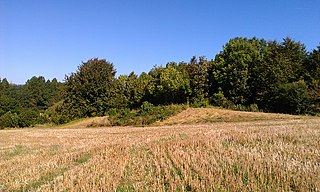
Wor Barrow is a Neolithic long barrow on Cranborne Chase, about 1 mile (1.6 km) east of Sixpenny Handley in Dorset, England. It is a scheduled monument.
The Thickthorn Down Long Barrows are two Neolithic long barrows, near the village of Gussage St Michael in Dorset, England. They are near the south-western end of the Dorset Cursus, a Neolithic feature. The long barrows are a scheduled monument.
This page is based on this Wikipedia article Text is available under the CC BY-SA 4.0 license; additional terms may apply. Images, videos and audio are available under their respective licenses.