The Neolithic, the final division of the Stone Age, began about 12,000 years ago when the first development of farming appeared in the Epipalaeolithic Near East, and later in other parts of the world. The division lasted until the transitional period of the Chalcolithic from about 6,500 years ago, marked by the development of metallurgy, leading up to the Bronze Age and Iron Age. In Northern Europe, the Neolithic lasted until about 1700 BC, while in China it extended until 1200 BC. Other parts of the world remained broadly in the Neolithic stage of development, although this term may not be used, until European contact.
The Bronze Age is a historical period characterized by the use of bronze, and in some areas proto-writing, and other early features of urban civilization. The Bronze Age is the second principal period of the three-age Stone-Bronze-Iron system, as proposed in modern times by Christian Jürgensen Thomsen, for classifying and studying ancient societies.
Staffordshire is a landlocked county in the West Midlands of England. It borders with Cheshire to the northwest, Derbyshire and Leicestershire to the east, Warwickshire to the southeast, West Midlands and Worcestershire to the south, and Shropshire to the west.
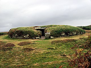
It consists of two round cairns linked by a connecting bank– an unusual layout and one that is unique in England. The northern cairn measures 23 metres (75ft) in diameter and survives to a height of 2.4 metres (7ft 10in). It appears to be related to other chamber tombs of the Peak District group and was excavated by Samuel Carrington in 1849. Carrington found a burial chamber built from limestoneorthostats with a paved floor. The bones of thirteen individuals were recovered as well as three leaf-shaped flint arrowheads.
A cairn is a human-made pile of stones. The word cairn comes from the Scottish Gaelic: càrn[ˈkʰaːrˠn̪ˠ].
A chamber tomb is a tomb for burial used in many different cultures. In the case of individual burials, the chamber is thought to signify a higher status for the interree than a simple grave. Built from rock or sometimes wood, the chambers could also serve as places for storage of the dead from one family or social group and were often used over long periods for multiple burials.
→
The smaller southern cairn is 15 metres (49ft) across and survives to 1.2 metres (3ft 11in) in height following extensive modern damage. It contained evidence of a cremation burial. Further cremations were found in the connecting bank which was built from a parallel row of limestone orthostats and is around 200 metres (660ft) long, 10 metres (33ft) wide and 2 metres (6ft 7in) high. It is now topped by a modern dry stone wall.
Because of the damage to the site, its rarity and the antiquity of the Carrington excavation it is unclear as to the precise nature of the monument. It is possible that the bank is a bank barrow which had a later Neolithic chambered cairn (the north cairn) built on one end and then a Bronze Age round barrow finally added at the southern end.
A bank barrow, sometimes referred to as a barrow-bank, ridge barrow, or ridge mound, is a type of tumulus first identified by O.G.S. Crawford in 1938.
A chambered cairn is a burial monument, usually constructed during the Neolithic, consisting of a sizeable chamber around and over which a cairn of stones was constructed. Some chambered cairns are also passage-graves. They are found throughout Britain and Ireland, with the largest number in Scotland.
A round barrow is a type of tumulus and is one of the most common types of archaeological monuments. Although concentrated in Europe, they are found in many parts of the world, probably because of their simple construction and universal purpose.
A geographic coordinate system is a coordinate system that enables every location on Earth to be specified by a set of numbers, letters or symbols. The coordinates are often chosen such that one of the numbers represents a vertical position and two or three of the numbers represent a horizontal position; alternatively, a geographic position may be expressed in a combined three-dimensional Cartesian vector. A common choice of coordinates is latitude, longitude and elevation. To specify a location on a plane requires a map projection.
This page is based on this Wikipedia article Text is available under the CC BY-SA 4.0 license; additional terms may apply. Images, videos and audio are available under their respective licenses.
Related Research Articles
A tumulus is a mound of earth and stones raised over a grave or graves. Tumuli are also known as barrows, burial mounds or kurgans, and may be found throughout much of the world. A cairn, which is a mound of stones built for various purposes, may also originally have been a tumulus.
Arbor Low is a Neolithic henge monument in the Peak District, Derbyshire, England. Arbor Low is in the White Peak area of the Peak District: the White Peak is a Carboniferous Limestone plateau lying between approximately 200 and 400 metres OD. The site is private property, accessible through the courtesy of the owner, and is managed by the Peak District National Park Authority. As of February 2017, an entrance fee of £1 per adult is requested by the landowner. Children can enter free of charge.
A gallery grave is a form of megalithic tomb built primarily during the Neolithic Age in Europe in which the main gallery of the tomb is entered without first passing through an antechamber or hallway. There are at least four major types of gallery grave, and they may be covered with an earthen mound or rock mound.
The entrance graves of Cornwall and the Isles of Scilly, and south east Ireland are megalithic chamber tombs of the Neolithic and early Bronze Age in the British Isles. Comparable sites are also known in Brittany and the Channel Islands. They are generally known as the Scillonian group as the greatest concentration of the tombs is found on the Isles of Scilly.
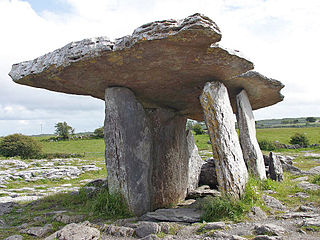
Poulnabrone dolmen is an unusually large dolmen or portal tomb located in the Burren, County Clare, Ireland. Situated on one of the most desolate and highest points of the region, it comprises three standing portal stones supporting a horizontal capstone, and dates to the Neolithic period, probably between 4200 BC and 2900 BC. It the best known and most widely photographed of the approximately 172 dolmens in Ireland.
Minninglow is a hill in the Peak District National Park in Derbyshire, located within the White Peak area at grid reference SK209573. Within the clump of trees crowning the hill are a Neolithic chambered tomb and two Bronze Age bowl barrows.
Pikestones is the remains of a Neolithic Burial Cairn, located on Anglezarke moor in Lancashire, England. The site is approximately 150 feet long and 60 feet across at its widest point. It consisted of one burial chamber constructed of large upright slabs, capped by two lintel slabs, forming a chamber of 15 feet long, 3 feet wide and 3 feet high, covered by a huge mound of stones and turves. The cairn was aligned almost exactly North-South, with the burial chamber under the wider northern end. At the northern edge of the cairn, a double wall could be made out, curving inwards to form an entrance to a forecourt.
Chapel Carn Brea is an elevated Hercynian granite outcrop, owned by the National Trust at the southern edge of the civil parish of St Just, Cornwall, England, United Kingdom. The hill is 5 kilometres (3.1 mi) south of St Just and 3.5 kilometres (2.2 mi) east of Sennen Cove, and just to the north of the A30 London to Land's End road, which runs through the village of Crows-an-Wra. It should not be confused with another Carn Brea, the hill overlooking the Camborne–Redruth area.
This article describes several characteristic architectural elements typical of European megalithic structures.
The Bull Ring is a Class II henge that was built in the late Neolithic period near Dove Holes in Derbyshire, England.
Lligwy Burial Chamber is a Neolithic burial chamber in Lligwy, near the east coast of Anglesey, Wales, United Kingdom. It consists of a circle of upright stones, made into a low chamber by a very large roof slab estimated at 25 tonnes. Excavation in 1909 found the remains of some 15 to 30 people, and pottery suggesting a late Neolithic date. Close to the village of Moelfre, the site is within a few metres of the road, where there is room to leave a single car for short periods.
The St Lythans burial chamber is a single stone megalithic dolmen, built around 6,000 BP as part of a chambered long barrow, during the mid Neolithic period, in what is now known as the Vale of Glamorgan, Wales.
Parc Cwm long cairn, also known as Parc le Breos burial chamber, is a partly restored Neolithic chambered tomb, identified in 1937 as a Severn-Cotswold type of chambered long barrow. The cromlech, a megalithic burial chamber, was built around 5850 years before present (BP), during the early Neolithic. It is about seven 1⁄2 miles (12 km) west south–west of Swansea, Wales, in what is now known as Coed y Parc Cwm at Parc le Breos, on the Gower Peninsula.
Midhowe Chambered Cairn is a large Neolithic chambered cairn located on the south shore of the island of Rousay, Orkney, Scotland. The name "Midhowe" comes from the Iron Age broch known as Midhowe Broch, that lies just west of the tomb. The broch got its name from the fact that it's the middle of three such structures that lie grouped within 500 metres (1,600 ft) of each other and Howe from the Old Norse word haugr meaning mound or barrow. Together, the broch and chambered cairn form part of a large complex of ancient structures on the shore of Eynhallow Sound separating Rousay from Mainland, Orkney.
Coetan Arthur dolmen, also known as Arthur's Quoit is the remains of a Neolithic burial chamber. It dates from around 3000 BCE. The site, situated on the hillside close to St Davids Head in Pembrokeshire, Wales, is the collapsed chamber of what is presumed to be a passage grave which also has a round barrow. The massive capstone measures approximately 6 metres by 2.5 metres and is supported on one side by an orthostat approximately 1.5 metres in height.
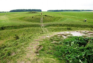
The Cursus Barrows is the name given to a Neolithic and Bronze Age round barrow cemetery located mostly south of the western end of the Stonehenge Cursus. The cemetery contains around 18 round barrows scattered along an east-to-west ridge, although some of the mounds are no longer visible. The Cursus Barrows can be seen just north of the route between the Stonehenge Visitor Centre and Stonehenge.
Battlegore Burial Chamber is a Bronze Age burial chamber located in Williton, Somerset. It is composed of three round barrows and possibly a long, chambered barrow. The site was excavated in 1931 by George Gray. The name "Battlegore" comes from this site being attributed to the location of a Danish raid in 918 AD or 988 AD. At least as early as the 14th century, the site was referred to as "Bytelgore", a predecessor of the word "Battlegore". Along with three nearby round barrows it has been scheduled as an ancient monument.
The Long Barrow at All Cannings is a modern barrow in Wiltshire, inspired by the neolithic barrows built 5,500 years ago. It was the first new barrow built in Britain in thousands of years.