Wetton, Staffordshire

Last updated

Wetton
Wetton village - geograph.org.uk - 942745.jpg
Wetton village and church
Staffordshire UK location map.svg
Red pog.svg
Wetton
Location within Staffordshire
OS grid reference SK110555
District
Shire county
Region
Country England
Sovereign state United Kingdom
Post town Ashbourne
Postcode district DE6
Dialling code 01335
Police Staffordshire
Fire Staffordshire
Ambulance West Midlands
UK Parliament
List of places
UK
England
Staffordshire
53°05′46″N1°50′17″W / 53.096°N 1.838°W / 53.096; -1.838

Wetton is a village in the Peak District National Park, North Staffordshire, at the top of the east side of the Manifold Valley. The population recorded in the 2001 Census was 157. At the time of the 2011 Census the population was recorded under Ilam. This article describes the location, some of the main features of the village, and a number of places of historical or general interest in or near the village. These include Long Low, Wetton, a prehistoric burial site unique to England.

Contents

Because the post town is Ashbourne, Derbyshire, many sources of tourist information wrongly describe Wetton as being in Derbyshire.

Location

Wetton is a small village in the Staffordshire Peak District. It is about 2 miles west of Alstonfield and 8½ miles east of Leek. It stands high above the Manifold valley and contains mostly stone-built properties. The village has an inn, and a church, part of which dates back to the 14th century. The church is unusual in that it has an external staircase to its belfry.

Wetton village

Sketch of Wetton Village with main features Wetton sketch plan.gif
Sketch of Wetton Village with main features
Wetton village viewed from Wetton Low with Wetton Hill in background Wetton 01.jpg
Wetton village viewed from Wetton Low with Wetton Hill in background

Wetton village is primarily a collection of farmhouses, with the gaps filled in by cottages and a few larger houses. Towards the centre of the village are the village green, Ye Olde Royal Oak public house, the church, and the former vicarage.

The village gives its name to Wetton Mill (or Wettonmill), a nearby hamlet on the River Manifold, and Wetton Hill (grid reference SK104563 ), which are both in the care of the National Trust.

There are many burial chambers or mounds in the area, including those on Wetton Hill itself, at Wetton Low, 1 kilometre (0.62 mi) south of the village, and Long Low, 2 kilometres (1.2 mi) to the south-east.

St Margaret's Parish Church

(1) on sketch plan.

The parish Church of St Margaret is the most obvious public building in the village. It is now in the Benefice of Alstonefield, in the Diocese of Lichfield. The present building was rebuilt in 1820, but the tower dates from the 14th century. [1]

Reading Room

(6) on sketch plan.

The Reading Room, by the churchyard gate opposite the village green, has not been in use for many decades. This may have been the "Club House" referred to by Rev. J. B. Dyson in his 1853 history of Methodism in the Leek Circuit as an early venue for Methodist meetings. [2]

School

(2) on sketch plan.

The village school closed because of falling pupil numbers. The building is now in use as the Village Hall and also houses a tea room. [3] The old village hall, situated on the road to Wetton Mill, was a corrugated iron construction which was unusable by the 1960s. [4] Children from Wetton now travel to Ilam or Warslow, along with those from nearby Alstonefield.

Methodist Chapel and Manse

(8) (9) on sketch plan.

The former Chapel and Manse are next to Town End Farm, which is the last farm on the north-east of the village.

The Old Police House

The village police house, with its cell, is now a residential home. It is between the village green and the former Methodist Chapel. Staffordshire Police rented the property from the Duke of Devonshire from 1876 for use as a police station. The cell was added in 1889, and the station was closed in 1941. The Charge Book is held in Staffordshire records office and this indicates that between 1890 and 1941 some 28 persons were detained overnight for various alleged offences. The adjoining property is the former schoolmistress's house.

The Royal Oak

(4) on sketch plan.

The Royal Oak public house is famous for the annual toe wrestling competition. [5] [6] [7] It is said that this sport began there in 1976, [8] [9] but was not raised to a championship event until 1993. [10] For many years the event took place at the Bentley Brook Inn at Fenny Bentley near Ashbourne, Derbyshire, but it returned to Wetton in 2015.

History

The various tumuli point to prehistoric Stone Age and Bronze Age settlements. Many local caves and cave-shelters have been excavated and have yielded evidence of inhabitation stretching far back into prehistory. For instance, items found in Thor's Cave, and now in the museum at Buxton, show evidence of early cave dwellers at the site.

Wetton is not recorded in the Norman Domesday Book of 1086, unlike neighbouring Alstonefield, Warslow and Stanshope. The earliest reference is to Wetindona in a document from the late 12th century. [11] The name may derive from Old English meaning 'wet hill'.

The English Heritage listing document for Wetton church has: "Early 14th century [tower, on which] ... gargoyles at belfry stage ... parapet band with gargoyles". [12]

The remains of an Anglo-Saxon settlement, with earlier evidence of Roman occupation, were found in nearby Borough Fields by the geologist Samuel Carrington in the mid-18th century, and excavated by his friend Thomas Bateman who was then the leading local antiquary. A full account of their excavations was given in Bateman's book Ten years’ diggings (1861). [13] Carrington and Bateman were enshrined in literature some years later as the leading characters "Hornblower" and "Flaxdale" in Eliza Meteyard's novel Dora and her Papa (1869), by which time Carrington was the Schoolmaster and Parish Clerk at Wetton. [14]

Industry

With the advent of the Mill at Wetton Mill, there was a surge in corn-growing along the valley tops. The number of disused lead mines in the area point to a range of other industries from around the 16th and 17th centuries.

In the late Victorian period the most significant heavy industry was related to the construction of the Leek and Manifold Light Railway and mining at Ecton.

Methodism

When the Wetton and Longnor Wesleyan Methodist Circuit was formed in 1870, Wetton was chosen for the Manse. In 1932, the Circuit incorporated various Primitive Methodist Chapels. The Circuit was disbanded in 1969. [15] The first Wesleyan Methodist building was opened in 1828. [16] The Primitive Methodists held meetings in Wetton, but did not establish a Chapel there. However, the Methodist Chapel at Ecton was Primitive Methodist, resulting from the industrial mission work from Ramsor and later the Leek Primitive Methodist Circuit. [17] After the completion of the railway in 1904, a building at Ecton became the Methodist Chapel there.

Places of interest

As a tourist destination, Wetton has a number of places of interest within the Parish.

Manifold Valley

The main tourist destination is the Manifold Valley. Several places may be noted (starting upstream).

Ecton

At the northern end of Wetton Parish, Ecton is most famous for the copper mine.

Swainsley

A little downstream from Ecton, this is the site of the only tunnel on the former railway. This was built because one of the owners of the railway lived there and did not want to be disturbed by passing trains. [18]

Wetton Mill

The bridge over the river Manifold at Wetton Mill Wetton Mill Bridge - geograph.org.uk - 72484.jpg
The bridge over the river Manifold at Wetton Mill

Wetton Mill was a water mill for grinding corn, and the remains of a mill stream, along with a grindstone, may still be seen. The mill is long since disused, but the Tea Room is popular with tourists. There is ample parking by the mill, on the site of the old halt, and the café is a popular stopping point for walkers using the Manifold Way and the many other rural walks that can incorporate parts of it. Immediately downstream from the mill are several "swallow holes" where the River Manifold begins to flow underground to Ilam.

The conclusion of the 14th-century chivalric romantic poem Sir Gawain and the Green Knight is thought to be set in the district. This is partly because the dialect in which the poem is written is now accepted by scholars as closely resembling that of the district, and also partly due to the extensive local work of R.W.V. Elliot in the 1970s. [19] This has led some to try to identify precisely the actual location of the story's climax. Mabel Day (1940) [20] proposed Nan Tor Cave, "at the bottom of the valley where the Hoo Brook runs into the Manifold at Wetton Mill" (near the site of the Wetton Mill train station), as a candidate for the Green Chapel. Her idea was later examined in detail by Robert Kaske (1972). [21]

Thor's Cave

Thor's Cave Thor's cave.jpg
Thor's Cave

Thor's Cave is a prominent landmark, both in the valley, and for some distance around. The cave is clearly visible from the moorland above Warslow. The main cave is near the top of a cliff overlooking the river; at the base of the cliff are a number of small caves only just above river level, which may be reached when the river bed is dry.

The Weags

The bridge where the road from Wetton to Grindon crosses the river is known as Weags Bridge. The valley sides are steep at this point, and the road has hairpin bends on both sides. As with much of the Manifold valley, the road is unsuitable for coaches.

Beeston Tor

Beeston Tor is a prominent rock face opposite the confluence of the River Hamps. This is popular with rock climbers.

Leek and Manifold Light Railway

Wetton was served by a railway station which was opened by the narrow gauge (2' 6") Leek and Manifold Valley Light Railway on 27 June 1904, whilst being entirely operated by the North Staffordshire Railway. The main purposes of the railway were to provide (1) more rapid transport for milk and dairy products from farms around the valley to customers in Leek and The Potteries, and (2) easier transport for the copper being mined at Ecton.

The village of Wetton was a good mile from the station, and the fact that the line followed the valley bottom whereas the settlements served by the railway were mostly on the hill-tops above was a contributary factor in its demise. The line closed in 1934, but in 1937 the route was reopened as the Manifold Way, a fully tarmacked 8-mile walk- and cycle-path which runs from Hulme End in the north to Waterhouses in the south.

Hills and other features

Wetton Hill

View near Wetton Hill On Wetton Hill - geograph.org.uk - 1233593.jpg
View near Wetton Hill

With a peak at 1221 feet above sea level, Wetton Hill is a prominent landmark. Views from the summit include Rugeley power station, some 25 miles south (now demolished).

Wetton Low

Wetton Low is another peak, almost due south of the village. The name Low comes from its use as a burial ground, with several tumuli. There are also a number of disused lead mines in this area, some in the form of adits. At one time a wooded area of the valley side near the Low was designated as a nature reserve.

Long Low

Long Low is a Neolithic and Bronze Age burial site of a rare form, unique to Britain. It is about a mile south east of the village, with Wetton Low about mid-way from Long Low to the village.

See also

Related Research Articles

<span class="mw-page-title-main">River Manifold</span> River in Staffordshire, England

The River Manifold is a river in Staffordshire, England. It is a tributary of the River Dove.

<span class="mw-page-title-main">Staffordshire Moorlands</span> Non-metropolitan district in England

Staffordshire Moorlands is a local government district in Staffordshire, England. Its council is based in Leek, the district's largest town. The district also contains the towns of Biddulph and Cheadle, along with a large rural area containing many villages. North-eastern parts of the district lie within the Peak District National Park.

<span class="mw-page-title-main">Hartington, Derbyshire</span> Human settlement in England

Hartington is a village in the centre of the White Peak area of the Derbyshire Peak District, England, lying on the River Dove which is the Staffordshire border. According to the 2001 census, the parish of Hartington Town Quarter, which also includes Pilsbury, had a population of 345 reducing to 332 at the 2011 Census. Formerly known for cheese-making and the mining of ironstone, limestone and lead, the village is now popular with tourists.

<span class="mw-page-title-main">Longnor, Staffordshire</span> Human settlement in England

Longnor is a village in the Staffordshire Peak District, England. The settlement dates from early times, the first recorded church building being in the Middle Ages. The village was named Longenalre in the Domesday Book. Located on a major crossroads, Longnor was a significant market town in the 18th century. It lies on the north bank of the River Manifold, on a limestone ridge between the Manifold and the River Dove.

<span class="mw-page-title-main">Ilam, Staffordshire</span> Human settlement in England

Ilam is a village in the Staffordshire Peak District of England, lying on the River Manifold. The population of the civil parish as taken at the 2011 census was 402.

The Leek and Manifold Valley Light Railway (L&MVLR) was a narrow gauge railway in Staffordshire, England that operated between 1904 and 1934. The line mainly carried milk from dairies in the region, acting as a feeder to the 4 ft 8+12 instandard gauge system. It also provided passenger services to the small villages and beauty spots along its route. The line was built to a 2 ft 6 in narrow gauge and to the light rail standards provided by the Light Railways Act 1896 to reduce construction costs.

<span class="mw-page-title-main">Dovedale</span> Valley in the Peak District, England

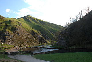
Dovedale is a valley in the Peak District of England. The land is owned by the National Trust and attracts a million visitors annually. The valley was cut by the River Dove and runs for just over 3 miles (5 km) between Milldale in the north and a wooded ravine, near Thorpe Cloud and Bunster Hill, in the south. In the wooded ravine, a set of stepping stones cross the river and there are two caves known as the Dove Holes.

<span class="mw-page-title-main">Hollinsclough</span> Human settlement in England

Hollinsclough is a small rural village in the county of Staffordshire in the English Midlands. It is within the Peak District National Park.

<span class="mw-page-title-main">Thor's Cave</span> Cave and archaeological site in the United Kingdom

Thor's Cave is a natural cavern located at SK09865496 in the Manifold Valley of the White Peak in Staffordshire, England. It is classified as a karst cave. Located in a steep limestone crag, the cave entrance, a symmetrical arch 7.5 metres wide and 10 metres high, is prominently visible from the valley bottom, around 80 metres (260 feet) below. Reached by an easy stepped path from the Manifold Way, the cave is a popular tourist spot, with views over the Manifold Valley. The second entrance is known as the "West Window", below which is a second cave, Thor's Fissure Cavern.

<span class="mw-page-title-main">Ecton, Staffordshire</span> Human settlement in England

Ecton is a hamlet in the Staffordshire Peak District. It is on the Manifold Way, an 8-mile (13 km) walk and cycle path that follows the line of the former Leek and Manifold Valley Light Railway. Population details as at the 2011 census can be found under Ilam.

<span class="mw-page-title-main">Manifold Way</span> Bridlepath in the English Peak District

The Manifold Way is a footpath and cycle way in Staffordshire, England. Some 8 miles (13 km) in length, it runs from Hulme End (53.1307°N 1.8480°W) in the north to Waterhouses (53.0480°N 1.8654°W) in the south, mostly through the Manifold Valley and the valley of its only tributary, the River Hamps, following the route of the former Leek and Manifold Valley Light Railway, a 2 ft 6 in gauge line which closed in 1934 after a short life.

<span class="mw-page-title-main">Grindon, Staffordshire</span> Human settlement in England

Grindon is a small village in the Staffordshire Peak District of England.

<span class="mw-page-title-main">Butterton</span> Human settlement in England

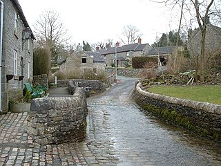
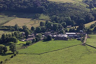
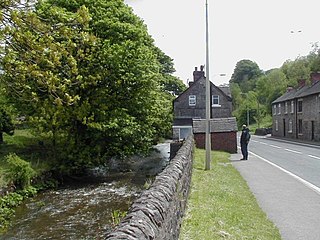
Butterton is a small village in the Staffordshire Peak District of England. It overlooks the Manifold Valley and Ecton Hill, which rises 1,212 feet above sea level. Butterton lies 5 miles east of Leek and roughly 8 miles from Alton Towers theme park. The village is just west of the limestone area, and so is mainly built of local sandstone. It contains a Grade II listed church. In the centre of Butterton there is an unusual ford where the Hoo Brook runs along the village street.

<span class="mw-page-title-main">Lud's Church</span> Rocky chasm in Englands Peak District

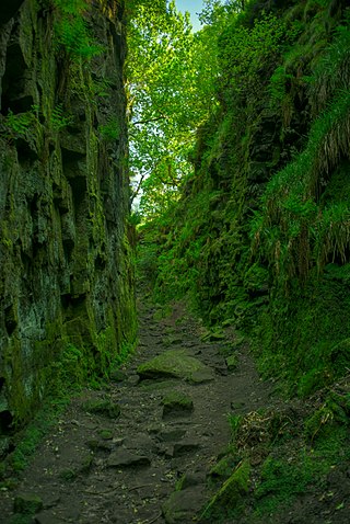
Lud's Church is a deep chasm penetrating the Millstone Grit bedrock created by a massive landslip on the hillside above Gradbach, Staffordshire, England. It is located in a wood known as Back Forest, in the Dark Peak, towards the southwest fringe of the Peak District National Park about 2.5 miles (4.0 km) west of the A53 between Leek and Buxton. Over 100 metres (328 ft) long and 18 metres (59 ft) deep, all but the upper third of the slope has slipped forward towards the River Dane. It is mossy and overgrown, wet and cool even on the hottest of days.

<span class="mw-page-title-main">Hulme End</span> Human settlement in England

Hulme End is a small hamlet in Staffordshire, England, in the Peak District National Park 10 miles north of Ashbourne, Derbyshire. A natural gateway to the Manifold Valley, the river crosses the road from Hartington to Warslow.

<span class="mw-page-title-main">Warslow</span> Human settlement in England

Warslow is a small village in Staffordshire, England. It is located in the Peak District National Park about 10 miles (16 km) north of Ashbourne. Although in the county of Staffordshire, the village lies close to the Derbyshire border, and has a Stockport postal code (SK), but the address is Warslow, Buxton, Derbyshire. Warslow has a public house, The Greyhound Inn circa 1750s 6 ensuite rooms for guests, Fresh food, music and cask Ales. Dogs welcome.

The tiny hamlet of Ramsor in North Staffordshire played a significant part in the origins of Primitive Methodism. Listed in the Domesday Book as Ramshorn, this ancient hamlet is a typical example of the depopulation of the countryside. Very little now remains of this village apart from a few farms and cottages. The Primitive Methodist Chapel is the only surviving public building.

Wetton Mill railway station was a minor station on the Leek and Manifold Light Railway serving the nearby Wetton Mill in Wetton, Staffordshire. The site is now part of the Manifold Way and runs past the mill today which is now a private and commercial residence.

Redhurst Crossing railway station was a minor station on the Leek and Manifold Light Railway, located between Wetton Mill railway station, Staffordshire and Thor's Cave railway station. Not much is documented about the halt, and the line which ran through it is now the Manifold Way.

<span class="mw-page-title-main">Warslow and Elkstones</span> Human settlement in England

Warslow and Elkstones is a civil parish in the district of Staffordshire Moorlands in north-east Staffordshire, England. It includes the village of Warslow and the hamlets of Lower Elkstone and Uppoer Elkstone. There is a boundary with Wetton in the east at the River Manifold. To the south is Butterton; the River Hamps forms the western boundary with Onecote.

References

  1. Wetton on A Church Near You web site
  2. Available on Rewlach Methodist history books archive
  3. "Tea room proposed at Wetton Village Hall". 26 September 2016. Retrieved 7 August 2017.
  4. Former resident and school pupil
  5. BBC Radio Stoke web site
  6. Off Track web site
  7. newspaper reports
  8. Origins and brief description on SportzFun
  9. comment on San Diego forum
  10. Derbyshire Peak District straying into Staffordshire
  11. Staffordshire Historical Collections 4th Series Volume IV. p. 31.
  12. Historic England. "Church of St. Margaret (Grade II*) (1227179)". National Heritage List for England . Retrieved 19 January 2022.
  13. Bateman, Thomas (1861). Ten years’ diggings in Celtic and Saxon grave hills, in the counties of Derby, Stafford, and York, from 1848 to 1858. George Allen & Sons. pp. 193–203.
  14. Notes and Queries, 10 February 1900, page 103.
  15. Rewlach Methodist history Circuit history diagram
  16. Dyson, op. cit.
  17. Minutes of a Quarterly Meeting held at Leek 10 March 1862
  18. Porter, Lindsay (2000). Leek & Manifold Light Railway. Ashbourne Editions. ISBN   1-873775-20-2.
  19. The essays of R.W.V. Elliot are collected in The Gawain Country: Essays on the Topography of Middle English Alliterative Poetry, Leeds Texts and Monographs 8, Leeds, 1984. See also Elliott’s later "Landscape and Geography" chapter in A Companion to the Gawain-poet, D.S.Brewer, 1998.
  20. Day, Mabel (1940). Introduction to Sir Gawain and the Green Knight. Vol. 210. Early English Text Society. p. xx.
  21. Kaske, Robert (1972). "Gawain's Green Chapel and the Cave at Wetton Mill". In Mandel, Jerome; Rosenberg, Bruce A. (eds.). Medieval Literature and Folklore Studies: Essays in Honor of Francis Lee Utley. New Jersey: Rutgers University Press.

Notes

  1. ^ The Wetton page of the Discover Derbyshire, Peak District web site (apparently claiming parts of Staffordshire as being across the border) has a very useful description of the village.