The Roaches

Last updated • 3 min readFrom Wikipedia, The Free Encyclopedia

The Roaches
The Roaches over nearby Leek.jpg
Highest point
Elevation 505 m (1,657 ft)
Prominence c. 120 m (394 ft)
Parent peak Shining Tor
Listing Dewey
Geography
Location Staffordshire, England
Parent range Peak District
OS grid SK001638
Topo map OS Landranger 119110

The Roaches (from the French les roches – the rocks) is a prominent rocky ridge above Leek and Tittesworth Reservoir in the Staffordshire Peak District of England. The ridge with its rock formations rises steeply to 505 m (1,657 ft). [1]

Contents

Along with Ramshaw Rocks and Hen Cloud, from Old English Henge Clud, meaning "steep rock", they form a gritstone escarpment, which is popular with hikers, rock climbers and freerunners. It is often very busy especially at weekends.

The Roaches Estate was purchased by the Peak District National Park Authority in the 1980s to safeguard the area from adverse development. From May 2013 Staffordshire Wildlife Trust took on the management of the Roaches Estate.

In clear conditions, it is possible to see much of Cheshire and views stretching as far as Snowdon in Wales and Winter Hill in Lancashire.

The Roaches are the most prominent part of a curving ridge which extends for several miles from Hen Cloud in the south to Back Forest and Hangingstone in the northwest. At the top there is a small pool called Doxey Pool that is, according to legend, inhabited by a water spirit. Nearby are the broad hills of Gun and Morridge.

Geology

Looking southeast over the Roaches and Hen Cloud The Roaches and Hen Cloud.jpg
Looking southeast over the Roaches and Hen Cloud

The Roaches, Hen Cloud and Ramshaw Rocks are formed from a thick bed of coarse sandstone ('gritstone') of Namurian age, a subdivision of the NW European Carboniferous system from ca 315 to 326.4 Ma, which occurs widely across the Peak District and takes its name, the Roaches Grit, from this location. The nearby Five Clouds are formed from a thinner bed of similar sandstone known as the Five Clouds Sandstone. These sandstones originated as delta sands dropped by major rivers draining a mountainous landmass to the north. The sandstone beds of both The Roaches and Hen Cloud dip moderately steeply to the east into the north–south-aligned syncline known as the Goyt Trough. The same beds at Ramshaw Rocks dip steeply to the northwest into the syncline. The southern end of the Roaches is defined by the presence of an east–west fault that runs through the col separating the Roaches from Hen Cloud. [2]

Wildlife

In the 1930s five Australian Bennett's wallabies were released into the wild from a private collection. [3] The colony survived into the 21st century [4] [5] but may now be extinct. [6]

In 2008, a pair of peregrine falcons successfully bred on the Roaches, causing climbing on part of the rock face to be suspended for a period. [7] Since then, the resident pair of peregrine falcons has had further successful hatchings, although there have also been cases of theft of eggs and young birds at the site. [8]

Doxey Pool

Climbers on Valkyrie at The Roaches Valkyrie (The Roaches).jpg
Climbers on Valkyrie at The Roaches

Doxey Pool (sometimes spelt Docksey) is a small pond, measuring about 15 by 10 metres (49 by 33 ft), by the top path of The Roaches at grid reference SK004628 . [9] Legend has it that this pool is inhabited by a mermaid called Jenny Greenteeth known as the blue nymph. The legend says that she fell in the pool on a foggy day whilst walking along the top of the Roaches, and ever since has been enticing unsuspecting victims down to the pool and to their watery grave. [10]

The Winking Man

The Winking Man Rock formation (also known as the Winking Eye [11] ) is part of the Ramshaw Rocks section of The Roaches. It can be seen from the Leek–Buxton road (A53) about 5 miles outside Leek. It looks like a face sticking out of the hillside, and as you travel past in a car towards Buxton the 'eye' appears to wink, as a pinnacle of rock passes behind the face as a consequence of parallax. [12] [11] A public house near Ramshaw Rocks at Upper Hulme takes its name from the Winking Man rock. [13]

Don Whillans Memorial Hut

Rockhall Cottage, the Don Whillans Memorial Hut at the Roaches Rock Hall - geograph.org.uk - 658482.jpg
Rockhall Cottage, the Don Whillans Memorial Hut at the Roaches

The Roaches is the site of the Don Whillans Memorial Hut, also known as the Rockhall Cottage. This Grade II listed building may have been a shooting box, and is built in cottage orné style. [14]

Related Research Articles

<span class="mw-page-title-main">Peak District</span> Upland area in England

The Peak District is an upland area in England, at the southern end of the Pennines. Mostly in Derbyshire, it extends into Cheshire, Greater Manchester, Staffordshire, West Yorkshire and South Yorkshire. It is subdivided into the Dark Peak, moorland dominated by gritstone, and the White Peak, a limestone area with valleys and gorges. The Dark Peak forms an arc on the north, east and west of the district, and the White Peak covers central and southern areas. The highest point is Kinder Scout. Most of the area is within the Peak District National Park, a protected landscape designated in 1951.

Rock climbing is a popular activity in the Peak District; particularly on edges such as Stanage or Froggatt. Generally the climbing style is free climbing and the rock is either gritstone or limestone. Climbing has been practised in the Peak District since the late 19th century; James W. Puttrell is generally credited with starting the sport. The first climbing guidebook to the area was Some Gritstone Climbs, by John Laycock, published in 1913. There are over 10,000 routes in the Peak District. One of the most famous Peak District climbers, and a pioneer of many new routes, is Ron Fawcett. The climb known as "Master's Edge", on Millstone Edge, near Hathersage, is a testament to his skill and strength. The climb is graded E7 6c and rises 19m up the near vertical edge.

<span class="mw-page-title-main">Leek, Staffordshire</span> Human settlement in England

Leek is a market town and civil parish in the county of Staffordshire, England, on the River Churnet. It is situated about 10 miles (16 km) north east of Stoke-on-Trent. It is an ancient borough and was granted its royal charter in 1214.

<span class="mw-page-title-main">River Manifold</span> River in Staffordshire, England

The River Manifold is a river in Staffordshire, England. It is a tributary of the River Dove.

<span class="mw-page-title-main">River Churnet</span> River in Staffordshire, England

The River Churnet is a river in Staffordshire, England. It is a tributary of the River Dove.

<span class="mw-page-title-main">Staffordshire Moorlands</span> Non-metropolitan district in England

Staffordshire Moorlands is a local government district in Staffordshire, England. Its council is based in Leek, the district's largest town. The district also contains the towns of Biddulph and Cheadle, along with a large rural area containing many villages. North-eastern parts of the district lie within the Peak District National Park.

<span class="mw-page-title-main">Flash, Staffordshire</span> Human settlement in England

Flash is a village in the Staffordshire Moorlands, England, and Peak District National Park. At 1,519 feet (463 m) above sea level, it is the highest village in the United Kingdom. Flash was an early centre for Wesleyanism.

<span class="mw-page-title-main">Shining Tor</span> Highest point in Cheshire, England

Shining Tor is the highest hill in Cheshire, England. The summit has a maximum elevation of 559 m (1,834 ft) above sea level. It is in the Peak District, between the towns of Macclesfield in Cheshire and Buxton in Derbyshire, and is on the administrative boundary between Derbyshire and Cheshire East. The hill is at the south end of a north-south moorland ridge, which also includes Cats Tor, 519 metres (1,703 ft) high. There is also another hill named Shining Tor, above Dovedale in Derbyshire, at grid reference SK145545.

<span class="mw-page-title-main">Upper Hulme</span>

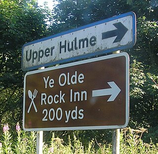
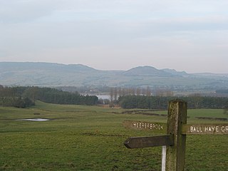
Upper Hulme is a hamlet in North Staffordshire, between the historic market town of Leek and the spa town of Buxton. It is clustered around a redundant mill and is located within the upper reaches of the River Churnet. The Mill was recently restored, with a working water wheel, but no further information on its future is known. It can be accessed by one of the many footpaths through the hamlet. The Peak District Boundary Walk runs through the village.

<span class="mw-page-title-main">Staffordshire Way</span> Long-distance footpath in Staffordshire, England

The Staffordshire Way is a long-distance walk in Staffordshire, England. The path links with the Cheshire Gritstone Trail, the Heart of England Way and the North Worcestershire Path.

<span class="mw-page-title-main">Millstone Grit</span>

Millstone Grit is the name given to any of a number of coarse-grained sandstones of Carboniferous age which occur in the British Isles. The name derives from its use in earlier times as a source of millstones for use principally in watermills. Geologists refer to the whole suite of rocks that encompass the individual limestone beds and the intervening mudstones as the Millstone Grit Group. The term Millstone Grit Series was formerly used to refer to the rocks now included within the Millstone Grit Group together with the underlying Edale Shale Group.

<span class="mw-page-title-main">Lud's Church</span> Rocky chasm in Englands Peak District

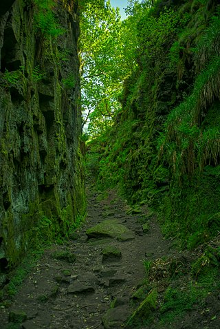
Lud's Church is a deep chasm penetrating the Millstone Grit bedrock created by a massive landslip on the hillside above Gradbach, Staffordshire, England. It is located in a wood known as Back Forest, in the Dark Peak, towards the southwest fringe of the Peak District National Park about 2.5 miles (4.0 km) west of the A53 between Leek and Buxton. Over 100 metres (328 ft) long and 18 metres (59 ft) deep, all but the upper third of the slope has slipped forward towards the River Dane. It is mossy and overgrown, wet and cool even on the hottest of days.

<span class="mw-page-title-main">Gun (Staffordshire)</span>

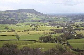
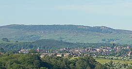
Gun is a hill at the southern end of the Peak District, overlooking the town of Leek in the Staffordshire Moorlands. The hill is mainly moorland with some small wooded areas. Neighbouring peaks to the east are The Roaches, Hen Cloud and Ramshaw Rocks. It is a nature reserve of the Staffordshire Wildlife Trust.

<span class="mw-page-title-main">The Cloud (hill)</span> Prominent hill in Englands Peak District

The Cloud or Bosley Cloud is a prominent hill on the border between Cheshire and Staffordshire a couple of miles west of the Peak District National Park boundary.

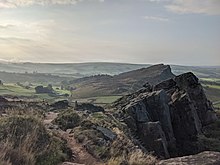
Roaches Grit is a coarse sandstone which outcrops widely throughout the western part of the Peak District of northern England and gives rise to several significant landscape features in the area. Its counterpart in the eastern part of the National Park is the Ashover Grit.

Some Gritstone Climbs is a rock climbing guidebook written by British lawyer John Laycock (1887–1960). The book's subtitle, included uniquely on the frontispiece, is Some Shorter Climbs . It was published in Manchester in 1913 by the Refuge Printing Department. Although focusing on rock climbing in the Peak District, it covers several adjacent cliffs outside this region, and despite its title, referring to the Millstone Grit geology of many of the cliffs, it includes several cliffs consisting of other rock types, including mountain limestone and red sandstone.

Simon Nadin is a British rock climber and professional photographer, who won the first ever IFSC Climbing World Cup in 1989.

<span class="mw-page-title-main">Derbyshire Dome</span> Geological formation of the Derbyshire Peak District

The Derbyshire Dome is a geological formation across mid-Derbyshire in England.

<span class="mw-page-title-main">Heathylee</span> Human settlement in England

Heathylee is a civil parish in the district of Staffordshire Moorlands in north-east Staffordshire, England.

The geology of the Peak District National Park in England is dominated by a thick succession of faulted and folded sedimentary rocks of Carboniferous age. The Peak District is often divided into a southerly White Peak where Carboniferous Limestone outcrops and a northerly Dark Peak where the overlying succession of sandstones and mudstones dominate the landscape. The scarp and dip slope landscape which characterises the Dark Peak also extends along the eastern and western margins of the park. Although older rocks are present at depth, the oldest rocks which are to be found at the surface in the national park are dolomitic limestones of the Woo Dale Limestone Formation seen where Woo Dale enters Wye Dale east of Buxton.

References

  1. Kent, Jeff, Staffordshire's 1,000-Foot Peaks, Witan Books, 2013, ISBN   978-0-9927505-0-3.
  2. British Geological Survey 1:50,000 map sheet 111 'Buxton' & associated memoir
  3. Laban, Linda (26 June 2017). "The English moor where wallabies roam". BBC. Retrieved 9 December 2020.
  4. "The Roaches". BBC Countryfile. Retrieved 17 October 2009.
  5. Lester, Paula. "Mow your grass with a wallaby". Country Life. Retrieved 17 October 2009.
  6. McCarthy, Michael (20 February 2013). "The decline and fall of the Peak District wallabies" . The Independent. Archived from the original on 18 June 2022. Retrieved 12 March 2018.
  7. "Peregrines breed successfully at the Roaches". BMC. 10 July 2008. Retrieved 21 October 2011.
  8. Douglas, Ed (11 June 2013). "Roaches peregrine chicks go missing". British Mountaineering Council. Retrieved 9 December 2020.
  9. OL24 White Peak area (Map). 1:25000. Explorer. Ordnance Survey.
  10. Smith, Roly; Andrew Bibby (2005). Peak District: Northern and Western Moors. Frances Lincoln. p. 137. ISBN   978-0-7112-2499-5.
  11. 1 2 Rodgers, Frank (1979). Curiosities of the Peak District. Ashbourne: Moorland Publishing. p. 148. ISBN   0903485478.
  12. "The Winking Man". The Megalithic Portal. Retrieved 9 December 2020.
  13. "The Winking Man – Upper Hulme". Visit Peak District. Visit Peak District & Derbyshire 2023.
  14. Historic England. "Rockhall Cottage (Grade II) (1293510)". National Heritage List for England . Retrieved 19 December 2023.

53°10′17″N2°00′00″W / 53.1713°N 2.0000°W / 53.1713; -2.0000