Grin Low

Last updated • 3 min readFrom Wikipedia, The Free Encyclopedia

Grin Low
Grin Low Hill near Buxton.jpg
View from the South
Highest point
Elevation 434 metres (1,424 ft)
Coordinates 53°14′42″N1°56′01″W / 53.245°N 1.9337°W / 53.245; -1.9337
Geography
Peak District National Park UK relief location map.png
Red triangle with thick white border.svg
Grin Low
Location in the Peak District
Derbyshire UK relief location map.jpg
Red triangle with thick white border.svg
Grin Low
Location in Derbyshire
Location Buxton, Derbyshire, England
OS grid SK054718
Topo map OS Explorer OL24

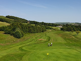
Grin Low is a hill overlooking Buxton in Derbyshire, in the Peak District. The summit is 434 metres (1,424 ft) above sea level. [1]

Remains of a lime kiln at Grin Low Remains of a lime kiln at Grin Low.jpg
Remains of a lime kiln at Grin Low

Grin Low was the main location for the early Buxton lime industry. It was an extensive area of limestone quarrying and was licensed for lime burning from 1662 by the 1st Duke Of Devonshire. Demand for lime grew dramatically during the Industrial Revolution. There are widespread remains of over 100 large 'pudding' lime kilns, built of earth and rock, which date from the 17th–19th centuries. The land is also covered in spoil heaps of waste material. Coal came from local collieries at Axe Edge and Goyts Moss. In 1820 the 6th Duke of Devonshire commissioned the 'Grin Plantation' (now the wooded Buxton Country Park) to shield the scarred lime-burning landscape from visitors to the spa town of Buxton. The Cromford and High Peak Railway opened in 1831 and passed by Grin Low. The railway allowed the lime to be transported to canals and generated expansion of quarrying in Buxton. In the 1850s lime production at Grin Low moved to a new large quarry on the south side of the hill (which was operated until its closure in 1952). In 1890 Grin Low produced 90,000 tonnes of lime. [2] [3] The quarry is now a caravan park and campsite. [4]

Grinlow Tower, known locally as Solomon's Temple Grinlow Tower aka Solomon's Temple.jpg
Grinlow Tower, known locally as Solomon's Temple

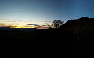
In the 1830s Solomon Mycock (proprietor of the Cheshire Cheese Inn) leased the land at the top of Grin Low. In 1840 he built Solomon's Temple (on behalf of the 6th Duke of Devonshire) at the summit, over an ancient burial mound, providing work to the unemployed of the town. By 1894 the structure of the folly had become dilapidated and the 8th Duke of Devonshire approved the replacement Grinlow Tower. The two-storey tower, 6 metres (20 ft) high, was designed by architects W. R. Bryden and George Garlick. The building was partly funded by public subscription. The new tower was opened by the Duke's cousin (and successor) Victor Cavendish in 1896. [2] [5] The tower was restored in 1987 with a partial contribution by Buxton residents. [6] Grinlow Tower is a Grade II listed building. [7] The structure is open with a spiral staircase inside to the viewing platform. There are panoramic views over Buxton to Mam Tor, Rushup Edge, Corbar Hill with Corbar Cross and in the opposite direction to Axe Edge. Temple Road in Buxton leads from the town to Grin Low.

In 1894, local archaeologist Micah Salt excavated the burial barrow at the summit of Grin Low hill, before the tower was rebuilt. He discovered the remains of three burials and two cremations, as well as a decorated bowl, a flint tool and other artefacts. [8]

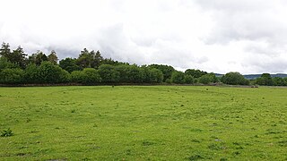
Buxton Country Park is operated by Buxton Civic Association and the park has 100 acres of mature woodland, with a network of woodland trails. The variety of trees include Beech, Ash, Elm, Sycamore, Willow, Birch, Hawthorn and Rowan. The woods are habitat to common birds (such as thrushes, tits and finches) but are also home to nuthatches, woodpeckers and tawny owls. The country park has had a 'Go Ape' tree-top adventure course with zip wires since 2007. [4] [9]

Poole's Cavern Pooles Cavern 2.jpg
Poole's Cavern

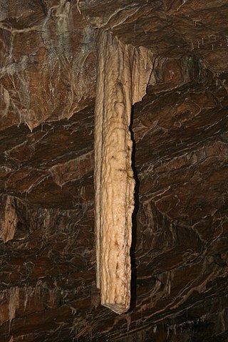
Poole's Cavern is at the foot of the hill on the north side, on the edge of Buxton town. This natural limestone cavern is two million years old, formed by underground water dissolving the rock. It has several large chambers with numerous stalactites and stalagmites. Stone Age, Bronze Age and Roman artefacts have been discovered inside. The cavern is named after a medieval outlaw named Poole who used it as a hiding place. It has been a tourist attraction since the 1600s when it was named as one of the Seven Wonders of the Peak by Thomas Hobbes (in his book De Mirabilibus Pecci). Mary Queen of Scots is believed to have visited during her stay in Buxton in 1582. A branch of the River Wye flows through the cave system. The cavern is open to the public with tours along its 300m main passage. The temperature is a constant 7 °C. [10] [11]

Poole's Cavern and Grin Low Wood are a designated Site of Special Scientific Interest (SSSI). [12]

The Dane Valley Way trail crosses the west side of the hill. [13]

Related Research Articles

<span class="mw-page-title-main">Buxton</span> Town in Derbyshire, England

Buxton is a spa town in the Borough of High Peak, Derbyshire, England. It is England's highest market town, sited at some 1,000 feet (300 m) above sea level. It lies close to Cheshire to the west and Staffordshire to the south, on the edge of the Peak District National Park. In 1974, the municipal borough merged with other nearby boroughs, including Glossop, to form the local government district and borough of High Peak.

<span class="mw-page-title-main">History of Derbyshire</span> History of the county of Derbyshire in England

The history of Derbyshire can be traced back to human settlement since the last Ice Age, over 10,000 years ago. The county of Derbyshire in England dates back to the 11th century.

<span class="mw-page-title-main">Robert Rippon Duke</span>

Robert Rippon Duke was an English architect and surveyor who designed various prominent Victorian buildings in Buxton, Derbyshire.

<span class="mw-page-title-main">Poole's Cavern</span> Cave in Derbyshire, England

Poole's Cavern or Poole's Hole is a two-million-year-old natural limestone cave on the edge of Buxton in the Peak District, in the county of Derbyshire, England.

<span class="mw-page-title-main">Solomon's Temple, Buxton</span> Historic site in near Buxton, Derbyshire

Solomon's Temple, also known as Grinlow Tower, is a Victorian folly on the summit of Grin Low hill, near the spa town of Buxton in the Derbyshire Peak District.

<span class="mw-page-title-main">Burbage, Derbyshire</span> Human settlement in England

Burbage is a village in Derbyshire and was a parish until 1961, when it became part of the parish of Buxton. At the 2011 Census Burbage was a ward of the High Peak Borough Council. The population taken at this Census was 2,540.

<span class="mw-page-title-main">Forest of High Peak</span> Royal forest in medieval Derbyshire

The Forest of High Peak was, in medieval times, a moorland forest covering most of the north west of Derbyshire, England, extending as far south as Tideswell and Buxton. From the time of the Norman Conquest it was established as a royal hunting reserve, administered by William Peverel, a follower of William I, who was based at Peveril Castle. The Royal Forest of Peak was bounded by the River Goyt to the west, the River Wye to the south, the River Derwent to the east and the River Etherow to the north. In 1305 it covered about 100 square miles.

<span class="mw-page-title-main">Harpur Hill Quarry</span> Disused limestone quarry in Derbyshire, England

Harpur Hill Quarry is a disused limestone quarry on Harpur Hill, Derbyshire, England. Limestone was extracted there from 1835 to 1952 for lime burning at lime kilns to produce quicklime. The quarry was used by the Royal Air Force as a chemical weapons storage depot during the Second World War, the largest such depot in the United Kingdom. Afterwards a number of captured German chemical munitions were disposed of at the site by burning, which was only partially successful. The RAF depot closed in 1960 and the site is now vacant.

<span class="mw-page-title-main">Buxton lime industry</span> History of the lime industry in Buxton, Derbyshire

The Buxton lime industry has been important for the development of the town of Buxton in Derbyshire, England, and it has shaped the landscape around the town.

<span class="mw-page-title-main">Derbyshire Dome</span> Geological formation of the Derbyshire Peak District

The Derbyshire Dome is a geological formation across mid-Derbyshire in England.

<span class="mw-page-title-main">Wye Valley, Derbyshire</span> Valley in the Derbyshire Peak District

The Wye Valley is the limestone valley of the River Wye in the White Peak of Derbyshire, England. The source of the River Wye is west of Buxton on Axe Edge Moor. One main channel runs underground through Poole's Cavern. The river flows though Buxton Pavilion Gardens and then along a culvert under the town centre. After leaving the flat area of central Buxton, the Wye Valley becomes distinct as a gorge running east for 10 miles (16 km) before the valley broadens at Ashford-in-the Water.

<span class="mw-page-title-main">Seven Wonders of the Peak</span> Historical attractions of the Derbyshire Peak District

The Seven Wonders of the Peak were described in the 17th century by the philosopher Thomas Hobbes in his book De Mirabilibus Pecci: Being The Wonders of the Peak in Darby-shire, Commonly called The Devil's Arse of Peak. The wonders refer to places to visit in the Peak District of Derbyshire in England.

<span class="mw-page-title-main">Burbage Edge</span> Hill in the Derbyshire Peak District

Burbage Edge is a gritstone escarpment overlooking the Burbage district of Buxton in Derbyshire, in the Peak District. The hill's summit is 500 metres (1,600 ft) above sea level.

<span class="mw-page-title-main">Corbar Hill</span> Hill in the Derbyshire Peak District

Corbar Hill is a sandstone hill at the south end of Combs Moss, overlooking Buxton in Derbyshire, in the Peak District. The summit is 437 metres (1,434 ft) above sea level.

<span class="mw-page-title-main">Staden, Derbyshire</span> Human settlement in England

Staden is a small hamlet on the southern outskirts of Buxton, Derbyshire, lying between Harpur Hill and Cowdale. It was occupied in Neolithic, Roman and medieval times. Staden is close to the limestone hilltop of Staden Low whose summit is 367 m (1,204 ft) above sea level.

<span class="mw-page-title-main">Buxton Racecourse</span> Former horse racing venue at Buxton in Derbyshire

Buxton Racecourse was a horse racing track in the 19th century on Fairfield Common near Buxton in Derbyshire, England. In 1804 an earlier racecourse field was recorded at Heathfield Nook, on the other side of Buxton town.

<span class="mw-page-title-main">Palace Hotel, Buxton</span> Listed building in Derbyshire, England

The Palace Hotel was opened in 1868 in Buxton, Derbyshire, England. It holds a prominent position in the town's central Conservation Area overlooking the town. It is a Grade-II listed building.

<span class="mw-page-title-main">Cavendish Golf Club</span> Golf course in Derbyshire, England

Cavendish Golf Club in Buxton, Derbyshire, opened in 1925 and was designed by Alister MacKenzie. The course is 5,721 yards (5,231 m) long with a par of 68. It is consistently voted as one of the top 100 golf courses in England.

William Radford Bryden was an English architect and surveyor who designed various prominent Victorian buildings in Buxton, Derbyshire.

<span class="mw-page-title-main">Micah Salt</span> British archaeologist

Micah Salt was a tailor and amateur archaeologist from Buxton in Derbyshire.

References

  1. "Grin Low". Hill Bagging – Database of British and Irish Hills. Retrieved 30 April 2020.
  2. 1 2 Leach, John (1987). The Book of Buxton. Baracuda Books Limited. pp. 14–15, 83–91, 124, 136. ISBN   0 86023 286 7.
  3. "Grin Low Lime Kilns, Buxton (HER No.2896)". www.heritagegateway.org.uk. Retrieved 13 April 2020.
  4. 1 2 "Grin Low and Buxton Country Park" (PDF). Retrieved 30 April 2020.
  5. Langham, Mike (2001). Buxton: A Peoples’ History. Lancaster: Carnegie Publishing Ltd. p. 187. ISBN   1859360866.
  6. "Solomon's Temple", Atlas Obscura , accessed 26 May 2019
  7. Historic England. "Grinlow Tower (1259254)". National Heritage List for England . Retrieved 30 April 2020.
  8. Leach, John (1987). The Book of Buxton. Baracuda Books Limited. pp. 22, 29. ISBN   0 86023 286 7.
  9. "Woodlands". Buxton Civic Association. Retrieved 30 April 2020.
  10. "Home". Pooles Cavern & Buxton Country Park. Retrieved 30 April 2020.
  11. "The Wonders of the Peak: Poole's Cavern". www.wondersofthepeak.org.uk. Retrieved 30 April 2020.
  12. "Poole's Cavern and Grin Low Wood" (PDF). Natural England. Retrieved 13 April 2020.
  13. OL24 White Peak area (Map). 1:25000. Explorer. Ordnance Survey. West sheet.