
High Peak is a local government district with borough status in Derbyshire, England, covering a high moorland plateau in the Dark Peak area of the Peak District National Park. The district stretches from Holme Moss in the north to Sterndale Moor in the south, and from Hague Bar in the west to Bamford in the east. The population of the borough taken at the 2011 Census was 90,892. The borough is unusual in having two administrative centres for its council, High Peak Borough Council; the offices are in Buxton and Glossop. Other towns include Chapel-en-le-Frith, Hadfield, New Mills and Whaley Bridge.
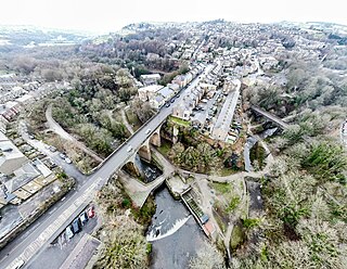
New Mills is a town in the Borough of High Peak, Derbyshire, England, 8 miles (13 km) south-east of Stockport and 13 miles (21 km) from Manchester at the confluence of the River Goyt and Sett. It is close to the border with Cheshire and above the Torrs, a 70 feet (21 m) deep gorge cut through carboniferous sandstone, on the north-western edge of the Peak District National Park.

Kinder Scout is a moorland plateau and National Nature Reserve in the Dark Peak of the Derbyshire Peak District in England. Part of the moor, at 636 metres (2,087 ft) above sea level, is the highest point in the Peak District, in Derbyshire and the East Midlands.

Wolfscote Hill is a limestone hill near the village of Hartington in the Derbyshire Peak District. The summit is 388 metres (1,273 ft) above sea level.

The River Kinder is a small river, only about 3 miles (4.8 km) long, in northwestern Derbyshire, England. Rising on the peat moorland plateau of Kinder Scout, it flows generally westwards to its confluence with the River Sett at Bowden Bridge. En route it flows through the Kinder Gates rocks, over the waterfall known as Kinder Downfall, and through Kinder Reservoir, built in 1903–12 by the Stockport Corporation Water Works. Until the 19th century at least, the name was formerly also applied to the River Sett as far as its confluence with the River Goyt in New Mills.
Lantern Pike is a hill located just outside Hayfield, in Derbyshire, England. The land lies within the Peak District National Park and is owned and maintained by the National Trust. It is permanently open to the public. According to Ordnance Survey, it is 373 metres (1,224 ft) in height.
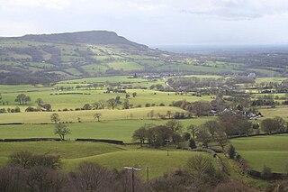
The Cloud or Bosley Cloud is a prominent hill on the border between Cheshire and Staffordshire a couple of miles west of the Peak District National Park boundary.

Higger Tor or Higgar Tor is a gritstone tor in the Dark Peak, in the north of the Peak District National Park in England. It overlooks the Burbage Valley and the Iron Age hill fort of Carl Wark to the southeast.

Sutton is a rural village and civil parish in the Central Bedfordshire district of Bedfordshire, England. It lies 11 miles (18 km) east of Bedford. At the 2001 Census, its population was 299. Main features are the packhorse bridge over the Potton Brook, the adjacent ford, and the Grade I listed All Saints' Parish Church.
Ranmoor/Endcliffe is a development of student accommodation for the University of Sheffield, located in Endcliffe in west Sheffield between Fulwood Road, Endcliffe Vale Road and Westbourne Road. The village accommodates most of the university's first-year undergraduates, alongside some second- and third-years, postgraduates and student families.

Brown Knoll is one of the highest hills in the Peak District in central England. It rises to a height of 569 metres (1,867 ft) above the head of the Edale valley and about 3 kilometres (1.9 mi) south-southwest of the Peak's highest point, Kinder Scout.

Chinley, Buxworth and Brownside is a civil parish within the High Peak district, which is in the county of Derbyshire, England. Partially rural with several villages contained within, its population was 2,794 residents in the 2021 census. The parish is 150 miles (240 km) north west of London, 35 miles (56 km) north west of the county city of Derby, and 1+1⁄3 miles (2.1 km) north of the nearest market town of Chapel-en-le-Frith. Being close to the edge of the county border, it shares a boundary with the parishes of Chapel-en-le-Frith, Edale, Hayfield, New Mills and Whaley Bridge. A substantial portion of the parish is within the Peak District national park.

Ethel Mary Bassett Haythornthwaite was an English environmental campaigner, activist and poet. She was a pioneer of countryside protection as well as town and country planning both locally and nationally. She founded the Sheffield Association for the Protection of Rural Scenery, also known as the Sheffield Association for the Protection of Local Countryside in 1924, which became the local branch of CPRE in 1927, and worked to protect the countryside of the Peak District from development. She forefronted the appeal to save the 747-acre Longshaw Estate from development, and helped acquire land around Sheffield that became its green belt. She was appointed to the UK government’s National Parks Committee, and helped to make the successful case for the National Parks and Access to the Countryside Act 1949, which led to the founding of the Peak District National Park in 1951. She also helped make green belts part of government policy in 1955.

The Peak District Boundary Walk is a circular 190-mile (310 km) walking trail, starting and finishing at Buxton and broadly following the boundary of the Peak District, Britain's first national park. The route was developed by the Friends of the Peak District and was launched on 17 June 2017.

The Friends of the Peak District is a UK registered charity which campaigns to protect England's Peak District National Park. The organisation is a branch of the Campaign to Protect Rural England (CPRE), whose purpose is "to promote and encourage for the benefit of the public the improvement and protection of the English countryside and the better development of the rural environment".

Kinder Reservoir is a public water storage reservoir on the western edge of Kinder Scout plateau in Derbyshire. The reservoir lies at the head of the Kinder Valley, 278 metres (912 ft) above sea level and 3 kilometres (1.9 mi) to the north east of the village of Hayfield. It is owned by United Utilities Group PLC.

Hollins Hill is a gritstone hill in the Derbyshire Peak District near the village of Hollinsclough. The summit is 450 metres (1,480 ft) above sea level. The hill is the source of Swallow Brook, which flows into the River Dove running along the south side of the hill.

South Head is a gritstone hill between the villages of Hayfield and Chinley in the Derbyshire Peak District. The summit is 494 metres (1,621 ft) above sea level. It lies at the south of the head of the River Sett.

Chinley Churn is a prominent gritstone hill between the villages of Chinley and Hayfield in the Derbyshire Peak District, England. The summit is 457 metres (1,499 ft) above sea level.

