Gun Moor was purchased when it came to the market in 2019. The Trust was aware that the moor was important and that it did not carry any protection; in order to secure the site, it was purchased by the Esmée Fairbairn Foundation, and the Trust agreed to buy the site within two years, at the original price. After donations from individuals and charitable trusts, this was achieved. Jeff Sim, Head of Nature Reserves and species recovery, said: "The habitat Gun Moor contains is what makes the Peak District Moors of international significance, so it is really important that the Trust was able to purchase and protect it."[4]
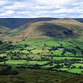
Gun Moor Meadow
During summer 2022, the Trust took out a loan to buy Gun Moor Meadow, bordering the north western edge of Gun Moor. In January 2023 the Trust announced that, thanks to donations, it was able to repay the loan.[5]
The meadow has area 7 acres (2.8ha). The land will be allowed to rewet, by filling in drainage ditches, and cattle will lightly graze at certain times of the year, so that bog asphodel and cranberry will be re-established; the land will attract wildlife whose habitat has been reduced in recent years.[6]
This page is based on this Wikipedia article Text is available under the CC BY-SA 4.0 license; additional terms may apply. Images, videos and audio are available under their respective licenses.