
Mam Tor is a 517 m (1,696 ft) hill near Castleton in the High Peak of Derbyshire, England. Its name means "mother hill", so called because frequent landslips on its eastern face have resulted in a multitude of "mini-hills" beneath it. These landslips, which are caused by unstable lower layers of shale, also give the hill its alternative name of Shivering Mountain.
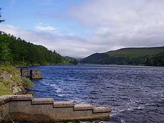
Derwent Reservoir is the middle of three reservoirs in the Upper Derwent Valley in the north of Derbyshire, England. It lies approximately 10 mi (16 km) from Glossop and 10 mi (16 km) from Sheffield. The River Derwent flows first through Howden Reservoir, then Derwent Reservoir and finally through Ladybower Reservoir. Between them they provide practically all of Derbyshire's water, as well as to a large part of South Yorkshire and as far afield as Nottingham and Leicester.

Edale is a village and civil parish in the Peak District, Derbyshire, England, whose population was 353 at the 2011 Census. Edale, with an area of 7,030 acres (2,840 ha), is in the Borough of High Peak.

Hathersage is a village and civil parish in the Peak District in Derbyshire, England. It lies slightly to the north of the River Derwent, approximately 10 miles (16.1 km) south-west of Sheffield.

Skiddaw is a mountain in the Lake District National Park in England. Its 931-metre (3,054 ft) summit is the sixth-highest in England. It lies just north of the town of Keswick, Cumbria, and dominates the skyline in this part of the northern lakes. It is the simplest of the Lake District mountains of this height to ascend and, as such, many walking guides recommend it to the occasional walker wishing to climb a mountain. This is the first summit of the fell running challenge known as the Bob Graham Round when undertaken in a clockwise direction.

A summit is a point on a surface that is higher in elevation than all points immediately adjacent to it. The topographic terms acme, apex, peak, and zenith are synonymous.

Great Dodd is a mountain or fell in the English Lake District. It stands on the main ridge of the Helvellyn range, a line of mountains which runs in a north-south direction between the lakes of Thirlmere and Ullswater in the east of the Lake District. Great Dodd, with a height of 857 m is the highest of the fells in this range to the north of Sticks Pass.

Grasmoor is a mountain in the north-western part of the Lake District, northern England. It is the highest peak in a group of hills between the villages of Lorton, Braithwaite and Buttermere, and overlooks Crummock Water.

Shining Tor is the highest hill in Cheshire, England. The summit has a maximum elevation of 559 m (1,834 ft) above sea level. It is in the Peak District, between the towns of Macclesfield in Cheshire and Buxton in Derbyshire, and is on the administrative boundary between Derbyshire and Cheshire East. The hill is at the south end of a north-south moorland ridge, which also includes Cats Tor, 519 metres (1,703 ft) high. There is also another hill named Shining Tor, above Dovedale in Derbyshire, at grid reference SK145545.

Galtymore or Galteemore is a mountain in the province of Munster, Ireland. At 917.9 metres, it is one of Ireland's highest mountains, being the 12th-highest on the Arderin list, and 14th-highest on the Vandeleur-Lynam list. Galtymore has the 4th-highest topographic prominence of any peak in Ireland, which classifies Galtymore as a P600, or "major mountain". It is one of the 13 Irish Munros.

Carl Wark is a rocky promontory on Hathersage Moor in the Peak District National Park, just inside the boundary of Sheffield, England. The promontory is faced by vertical cliffs on all but one side, which is protected by a prehistoric embankment. The cliffs and embankment form an enclosure that has been interpreted as an Iron Age hill fort, though the date of construction and purpose of the fortifications remains unknown. The site is a scheduled monument.

Crook Hill is a small hill in the Peak District National Park in the English county of Derbyshire, 5 kilometres (3.1 mi) northeast of Castleton.

Derwent Edge is a Millstone Grit escarpment that lies above the Upper Derwent Valley in the Peak District National Park in the English county of Derbyshire. An Ordnance Survey column marks the highest point of the Edge at Back Tor. North of Back Tor the edge extends into Howden Edge and enters the county of South Yorkshire.

Doll Tor is a stone circle located just to the west of Stanton Moor, near the village of Birchover, Derbyshire in the English East Midlands. Doll Tor is part of a tradition of stone circle construction that spread throughout much of Britain, Ireland, and Brittany during the Late Neolithic and Early Bronze Ages, over a period between 3300 and 900 BCE. The purpose of such monuments is unknown, although archaeologists speculate that the stones represented supernatural entities for the circles' builders.

The Milseburg is an extinct volcano and at 835 metres (2,740 ft) above sea level the second highest elevation in the Hessian part of the Rhön Mountains, Germany. The hill is located east of Fulda, near the villages of Kleinsassen and Danzwiesen. It is a popular destination for hikers and bikers. Scientifically, Milseburg is most notable for the remains of a large Celtic oppidum. It also features several other structures on the peak, including a chapel dedicated to St Gangulphus.

The Kilpatrick Hills are a range of hills in central Scotland, stretching from Dumbarton in the west to Strathblane in the east. Strathblane divides the Kilpatricks from the Campsie Fells to the east, while to the north is part of the Loch Lomond and the Trossachs National Park. To west and south the hills are fringed by the settlements of Balloch, Dumbarton, Milton, Bowling, Old Kilpatrick, Clydebank, Bearsden and Milngavie. The majority of the range is within West Dunbartonshire, although it extends into the East Dunbartonshire and Stirling areas.

Eyam Moor is a plateau-topped hill between the villages of Eyam and Hathersage in Derbyshire, in the Peak District of England. The summit of Sir William Hill is 429 metres (1,407 ft) above sea level.

Totley Moor is an open moorland hill to the west of the Sheffield suburb of Totley, in the Derbyshire Peak District. The summit is 395 metres (1,296 ft) above sea level.
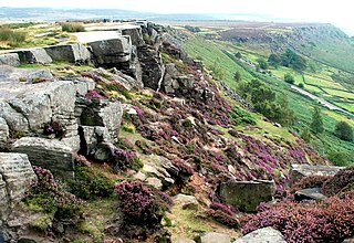
Curbar Edge is a gritstone moorland escarpment above the village of Curbar, in Derbyshire, England and close to the villages of Baslow, Calver, and Froggatt. It is located within the Peak District National Park at an altitude of 958 ft (292 m). It is regarded as a significant location for rock climbing, both regionally and nationally, in terms of both the historical development of the sport and as the location of first ascents.

Northwood and Tinkersley is a civil parish within the Derbyshire Dales district, in the county of Derbyshire, England. Named for its main settlements, with a mix of rural and built up areas, it had a population of 665 residents in 2011. The parish is 126 miles (203 km) north west of London, 18 miles (29 km) north west of the county city of Derby, and 3+1⁄2 miles (5.6 km) north west of the nearest market town of Matlock. Northwood and Tinkersley is directly adjacent to the Peak District national park to the west, and shares a border with the parishes of Darley Dale, Rowsley and Stanton.


