
Leek is a market town and civil parish in the county of Staffordshire, England, on the River Churnet. It is situated about 10 miles (16 km) north east of Stoke-on-Trent. It is an ancient borough and was granted its royal charter in 1214.

Caldon Canal is a branch of the Trent and Mersey Canal which opened in 1779. It runs 18 miles (29 km) from Etruria, Stoke-on-Trent, to Froghall, Staffordshire. The canal has 17 locks and the 76-yard (69 m) Froghall Tunnel.

The Churnet Valley Railway is a preserved standard gauge heritage railway in the Staffordshire Moorlands of Staffordshire, England. It operates on part of the former Churnet Valley Line.which was opened by the North Staffordshire Railway. The railway is roughly 10.5 miles (16.9 km) long from Kingsley and Froghall to Ipstones. The land from Leek Brook Junction to Ipstones was opened by Moorland & City Railways (MCR) in 2010 after they took a lease out from Network Rail. This has subsequently been purchased by the Churmet Valley Railway. The main stations along the line are Kingsley and Froghall, Consall, Cheddleton and Leek Brook. Work has begun to extend the line to the town of Leek which will act as the northern terminus of the line. The line between Leek and Waterhouses has also been reopened as part of the heritage railway far as Ipstones.
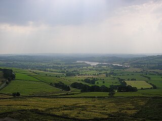
Tittesworth Reservoir is a water storage reservoir near Leek, Staffordshire, England, fed by the River Churnet. The reservoir and associated water treatment works are owned and operated by Severn Trent Water. The reservoir was built in 1858 and extended in 1963. Tittesworth is the second largest reservoir by volume in the county of Staffordshire. The Peak District Boundary Walk runs past the reservoir.

Staffordshire Moorlands is a constituency represented in the House of Commons of the UK Parliament since 2010 by Karen Bradley, a Conservative who served as Secretary of State for Culture, Media and Sport between 2016 and 2018, before she became Secretary of State for Northern Ireland from 2018 to 2019. As with all constituencies, the constituency elects one Member of Parliament (MP) by the first past the post system of election at least every five years. This seat has seen a swing to the Conservatives at the past four elections.
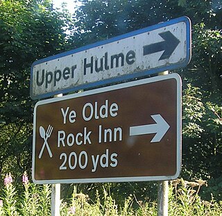
Upper Hulme is a hamlet situated in North Staffordshire, between the historical market town of Leek and the spa town of Buxton. It is clustered around a redundant mill and is located within the upper reaches of the River Churnet. The Mill was recently restored, complete with a working water wheel, but no further information on its future is known. It can be accessed by one of the many footpaths through the hamlet. The Peak District Boundary Walk runs through the village.

Bradnop is a village in Staffordshire, England, located just a few miles to the southeast of the market town of Leek. The name Bradnop was first recorded in 1197, and gets its name from the Old English words "bradan", meaning broad, and "hop", meaning enclosed valley. Historically Bradnop was a township of the parish of Leek, and later became a civil parish in its own right, with an area 3,568 acres.

Ball Haye Green is an area of Leek in Staffordshire, England. The area was historically an estate in the township of Tittesworth. It was developed as a suburb of Leek from the 1820s, when the Leek Building Society erected 42 houses between 1824 and 1829. The suburb was extended in the 20th century by the building of housing estates.
Swythamley Hall is a late 18th-century country house near Leek, Staffordshire which has been converted into four separate residences. It is a Grade II listed building.

Meerbrook is a small village in North Staffordshire, on the River Churnet at the edge of the Peak District National Park. It is situated four miles north of the town of Leek, in the parish of Leekfrith. The Roaches and Hen Cloud, popular walking and climbing locations, are very nearby.

St Edward's Hospital was a mental health facility at Cheddleton in Staffordshire, England. The hospital closed in 2002 and was converted into apartments and houses.

Ipstones railway station was a railway station that served the village of Ipstones, Staffordshire. It was opened by the North Staffordshire Railway (NSR) in 1905 and closed to passenger use in 1935, but remained open to freight traffic until 1964.
The Waterhouses branch line was a railway built by the North Staffordshire Railway to link the small villages east of Leek, Staffordshire with Leek, the biggest market town in the area. The railway opened in 1905 but closed to passengers in 1935. Freight continued on the line though until 1988, when the line was mothballed as the traffic from the quarries at Caldon Low ceased.

Heaton is a small village and civil parish in Staffordshire, England. It is about 4 miles (6.4 km) north of Leek and about 7 miles (11 km) south of Macclesfield.
Leekfrith is a civil parish in the Staffordshire Moorlands, in Staffordshire, England, north of the town of Leek. The population of the civil parish at the 2011 census was 363.
Leek railway station is the proposed and future terminus of the Churnet Valley Railway and is currently awaiting construction. It will be the second railway station in Leek.

Deep Hayes Country Park is a country park in Staffordshire, England. It is about 3 miles (4.8 km) south-west of Leek, a short distance south of the A53 road at Longsdon.

Stanley is a small village in the Staffordshire Moorlands district of Staffordshire, England, about 4 miles (6.4 km) southwest of Leek. The village of Bagnall is about 1 mile (1.6 km) to the south.
Tittesworth is a civil parish in the district of Staffordshire Moorlands, Staffordshire, England. It contains six listed buildings that are recorded in the National Heritage List for England. All the listed buildings are designated at Grade II, the lowest of the three grades, which is applied to "buildings of national importance and special interest". The parish contains the village of Thorncliffe and is otherwise rural. The listed buildings consist of farmhouses and farm buildings, a spring head cover, and a milepost.

Heathylee is a civil parish in the district of Staffordshire Moorlands in north-east Staffordshire, England.

