The Peak District is an upland area in England, at the southern end of the Pennines. Mostly in Derbyshire, it extends into Cheshire, Greater Manchester, Staffordshire, West Yorkshire and South Yorkshire and includes the Dark Peak, moorland dominated by gritstone, and the White Peak, a limestone area with valleys and gorges. The Dark Peak forms an arc on the north, east and west sides; the White Peak covers central and southern tracts. The Peak District was the first of the national parks of England and Wales in 1951. The historic Peak District extends beyond the National Park, which excludes major towns, quarries and industrial areas. Nearby Manchester, Stoke-on-Trent, Derby and Sheffield send millions of visitors. Inhabited from the Mesolithic era, it shows evidence of the Neolithic, Bronze and Iron Ages. Settled by the Romans and Anglo-Saxons, it remained largely agricultural; mining arose in the Middle Ages. Richard Arkwright built cotton mills in the Industrial Revolution. As mining declined, quarrying grew. Tourism came with the railways, spurred by the landscape, spa towns and Castleton's show caves.

The Derwent is a river in Derbyshire, England. It is 50 miles (80 km) long and is a tributary of the River Trent, which it joins south of Derby. Throughout its course, the river mostly flows through the Peak District and its foothills.

The River Manifold is a river in Staffordshire, England. It is a tributary of the River Dove.

The North Platte River is a major tributary of the Platte River and is approximately 716 miles (1,152 km) long, counting its many curves. In a straight line, it travels about 550 miles (890 km), along its course through the U.S. states of Colorado, Wyoming, and Nebraska.

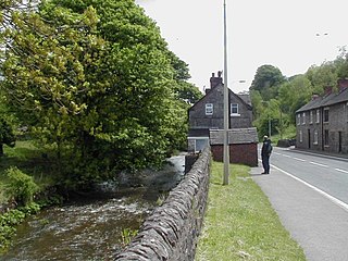
Ilam is a village in the Staffordshire Peak District of England, lying on the River Manifold. The population of the civil parish as taken at the 2011 census was 402.
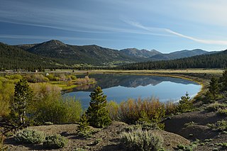
The Yampa River flows 250 miles (400 km) through northwestern Colorado, United States. Rising in the Rocky Mountains, it is a tributary of the Green River and a major part of the Colorado River system. The Yampa is one of the few free-flowing rivers in the western United States, with only a few small dams and diversions.

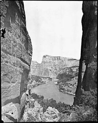
The Dolores River is a tributary of the Colorado River, approximately 241 miles (388 km) long, in the U.S. states of Colorado and Utah. The river drains a rugged and arid region of the Colorado Plateau west of the San Juan Mountains. Its name derives from the Spanish El Rio de Nuestra Señora de Dolores, River of Our Lady of Sorrows. The river was explored and possibly named by Juan Maria Antonio Rivera during a 1765 expedition from Santa Fe.

The Sevier River is a 400-mile (640 km)-long river in the Great Basin of southwestern Utah in the United States. Originating west of Bryce Canyon National Park, the river flows north through a chain of high farming valleys and steep canyons along the west side of the Sevier Plateau before turning southwest and terminating in the endorheic basin of Sevier Lake in the Sevier Desert. It is used extensively for irrigation along its course, with the consequence that Sevier Lake is usually dry.

The River Dove is the principal river of the southwestern Peak District, in the Midlands of England and is around 45 miles (72 km) in length. It rises on Axe Edge Moor near Buxton and flows generally south to its confluence with the River Trent at Newton Solney. From there, its waters reach the North Sea via the Humber Estuary. For almost its entire course it forms the boundary between the counties of Staffordshire and Derbyshire. The river meanders past Longnor and Hartington and cuts through a set of deep limestone gorges, Beresford Dale, Wolfscote Dale, Milldale and Dovedale.
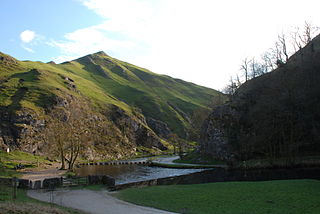
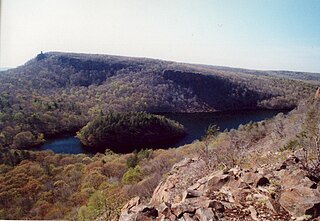
Dovedale is a valley in the Peak District of England. The land is owned by the National Trust and attracts a million visitors annually. The valley was cut by the River Dove and runs for just over 3 miles (5 km) between Milldale in the north and a wooded ravine, near Thorpe Cloud and Bunster Hill, in the south. In the wooded ravine, a set of stepping stones cross the river and there are two caves known as the Dove Holes.
Waterhouses is a village in the south of the Staffordshire Peak District in England. It is around 8 miles from Leek and Ashbourne, being nearly the halfway point between the two towns on the A523 road, which roughly follows the southern boundary of the Peak District National Park. Waterhouses is also a civil parish, created in 1934 when the parishes of Calton, Cauldon, Waterfall and part of Ilam were merged; previously the village of Waterhouses was on the boundary of Waterfall and Cauldon parishes. The hamlet of Winkhill is also in the parish. The population of the civil parish at the 2011 census was 1,134.

The Manifold Way is a footpath and cycle way in Staffordshire, England. Some 8 miles (13 km) in length, it runs from Hulme End (53.1307°N 1.8480°W) in the north to Waterhouses (53.0480°N 1.8654°W) in the south, mostly through the Manifold Valley and the valley of its only tributary, the River Hamps, following the route of the former Leek and Manifold Valley Light Railway, a 2 ft 6 in gauge line which closed in 1934 after a short life.

Grindon is a small village in the Staffordshire Peak District of England.
The Hanging Hills of south central Connecticut, United States are a range of mountainous trap rock ridges overlooking the city of Meriden and the Quinnipiac River Valley 900 feet (274 m) below. They are a sub-range of the narrow, linear Metacomet Ridge that extends from Long Island Sound near New Haven, Connecticut, north through the Connecticut River Valley of Massachusetts to the Vermont border. A popular outdoor recreation resource, the range is known for its microclimate ecosystems, rare plant communities, and expansive views from cliffs that rise abruptly over 700 feet (213 m) above the surrounding landscape. The Hanging Hills encompass the 1,800-acre (7.3 km2) Hubbard Park, designed with the help of landscape architect Frederick Law Olmsted. The 51 mile (80k) Metacomet Trail traverses the range.

Carboniferous Limestone is a collective term for the succession of limestones occurring widely throughout Great Britain and Ireland that were deposited during the Dinantian Epoch of the Carboniferous Period. These rocks formed between 363 and 325 million years ago. Within England and Wales, the entire limestone succession, which includes subordinate mudstones and some thin sandstones, is known as the Carboniferous Limestone Supergroup.

The River Nidd is a tributary of the River Ouse in the English county of North Yorkshire. In its first few miles it is dammed three times to create Angram Reservoir, Scar House Reservoir and Gouthwaite Reservoir, which attract a total of around 150,000 visitors a year. The Nidd can overflow the reservoirs, flooding the caves in the valley. In such cases the river overflows into the normally dry river bed past Lofthouse through to Gouthwaite Reservoir. The Yorkshire Dales Rivers Trust YDRT has a remit to conserve the ecological condition of the River Nidd from its headwaters to the Humber estuary.
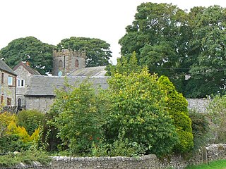
Wetton is a village in the Peak District National Park, North Staffordshire, at the top of the east side of the Manifold Valley. The population recorded in the 2001 Census was 157. At the time of the 2011 Census the population was recorded under Ilam. This article describes the location, some of the main features of the village, and a number of places of historical or general interest in or near the village. These include Long Low, Wetton, a prehistoric burial site unique to England.
The Waterhouses branch line was a railway built by the North Staffordshire Railway to link the small villages east of Leek, Staffordshire with Leek, the biggest market town in the area. The railway opened in 1905 but closed to passengers in 1935. Freight continued on the line though until 1988, when the line was mothballed as the traffic from the quarries at Caldon Low ceased.

The Peak District Boundary Walk is a circular 190-mile (310 km) walking trail, starting and finishing at Buxton and broadly following the boundary of the Peak District, Britain's first national park. The route was developed by the Friends of the Peak District and was launched on 17 June 2017.