
A rock shelter is a shallow cave-like opening at the base of a bluff or cliff. In contrast to solutional caves (karst), which are often many miles long or wide, rock shelters are almost always modest in size and extent.

Indian architecture is rooted in the history, culture, and religion of India. Among several architectural styles and traditions, the best-known include the many varieties of Hindu temple architecture and Indo-Islamic architecture, especially Rajput architecture, Mughal architecture, South Indian architecture, and Indo-Saracenic architecture. Early Indian architecture was made from wood, which did not survive due to rotting and instability in the structures. Instead, the earliest existing architecture are made with Indian rock-cut architecture, including many Buddhist, Hindu, and Jain temples.

A petroglyph is an image created by removing part of a rock surface by incising, picking, carving, or abrading, as a form of rock art. Outside North America, scholars often use terms such as "carving", "engraving", or other descriptions of the technique to refer to such images. Petroglyphs, estimated to be 20,000 years old are classified as protected monuments and have been added to the tentative list of UNESCO's World Heritage Sites. Petroglyphs are found worldwide, and are often associated with prehistoric peoples. The word comes from the Greek prefix petro-, from πέτρα petra meaning "stone", and γλύφω glýphō meaning "carve", and was originally coined in French as pétroglyphe.

A megalith is a large stone that has been used to construct a prehistoric structure or monument, either alone or together with other stones. There are over 35,000 in Europe alone, located widely from Sweden to the Mediterranean sea.

Cup and ring marks or cup marks are a form of prehistoric art found in the Atlantic seaboard of Europe (Ireland, Wales, Northern England, Scotland, France, Portugal, and Spain – and in Mediterranean Europe – Italy, Azerbaijan and Greece, as well as in Scandinavia and in Switzerland.

In archaeology, rock arts are human-made markings placed on natural surfaces, typically vertical stone surfaces. A high proportion of surviving historic and prehistoric rock art is found in caves or partly enclosed rock shelters; this type also may be called cave art or parietal art. A global phenomenon, rock art is found in many culturally diverse regions of the world. It has been produced in many contexts throughout human history. In terms of technique, the four main groups are:
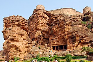
Badami, formerly known as Vātāpi, is a town and headquarters of a taluk by the same name, in the Bagalkot district of Karnataka, India. It was the regal capital of the Badami Chalukyas from 540 to 757. It is famous for its rock cut monuments such as the Badami cave temples, as well as the structural temples such as the Bhutanatha temples, Badami Shivalaya and Jambulingesvara Temple. It is located in a ravine at the foot of a rugged, red sandstone outcrop that surrounds Agastya lake.
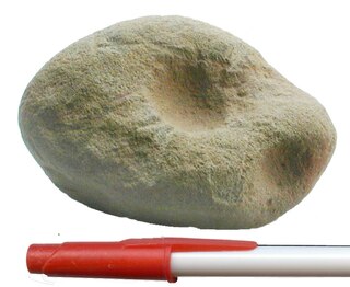
Cupstones, also called anvil stones, pitted cobbles and nutting stones, among other names, are roughly discoidal or amorphous groundstone artifacts among the most common lithic remains of Native American culture, especially in the Midwestern United States, in Early Archaic contexts. The hemispherical indentation itself is an important element of paleoart, known as a "cupule". Cup and ring marks are also common in the Fertile Crescent and India, and later in the Mediterranean, Atlantic, and Alpine regions of Europe, sometimes associated with complex petroglyphs or megalithic monuments.

North Karnataka is a geographical region in Deccan plateau from 300 to 730 metres elevation that constitutes the region of the Karnataka state in India and the region consists of 14 districts. It is drained by the Krishna River and its tributaries the Bhima, Ghataprabha, Malaprabha, and Tungabhadra. North Karnataka lies within the Deccan thorn scrub forests ecoregion, which extends north into eastern Maharashtra.
Ron is a taluka headquarters in Gadag district, Karnataka in India. Of historical importance, the town was termed Dronapur in ancient times. The temples are believed to be constructed by the ancient architect and warrior-priest Dronacharya.
The Kupgal petroglyphs are works of rock art found at Kupgal in Bellary district of Karnataka, India. Thousands of petroglyphs have been found at Kupgal, which date to the neolithic or even the old stone age. The site, which includes examples of rock gongs, was discovered first in 1892, but subsequently became lost to researchers until it was rediscovered in the early 21st century. This site features peculiar rock formations with unusual depressions which make musical sounds when struck with boulders.
Brahmagiri is an archaeological site located in the Chitradurga district of the state of Karnataka, India. Legend has it that this is the site where sage Gautama Maharishi and his wife Ahalya lived. He was one among seven noted Hindu saints. This site was first explored by Benjamin L. Rice in 1891, who discovered rock edicts of Emperor Ashoka here. These rock edicts indicated that the locality was termed as Isila and denoted the southernmost extent of the Mauryan empire. The Brahmagiri site is a granite outcrop elevated about 180 m. above the surrounding plains and measures around 500 m east-west and 100 m north-south. It is well known for the large number of megalithic monuments that have been found here. The earliest settlement found here has been dated to at least the 2nd millennium BC.
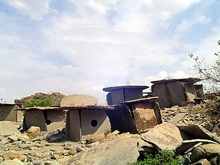
Morera Thatte is an archaeological site consisting of a number of stone structures on Chikkabenkal hill near Gangavathi in Koppal district, India, dating back to the Stone Age. These houses are said to have been constructed 3,000 years ago. These houses have been built from stone slabs, with a circular opening serving as a door.
Byse is a village in the Shimoga district of Karnataka, India. It is located around 140 km from Mangalore, in the Nagara hobli of the Hosanagara taluka.
Hirebenakal or Hirébeṇakal or Hirébeṇakallu is a megalithic site in the state of Karnataka, India. It is among the few megalithic sites in India that can be dated to the 800 BCE to 200 BCE period. The site is located in the Koppal district, some 10 kilometres (6.2 mi) west of the town of Gangavati and some 35 kilometres (22 mi) from Hospet city. It contains roughly 400 megalithic funerary monuments, that have been dated to the transition period between Neolithic period and the Iron Age. Known locally as eḷu guḍḍagaḷu, their specific name is moryar guḍḍa. Hirebenakal is reported to be the largest necropolis among the 2000 odd megalithic sites found in South India, most of them in the state of Karnataka. Since 1955, it has been under the management of the Dharwad circle of the Archaeological Survey of India (ASI). On May 19, 2021, it was proposed that Hirebenakal be made a UNESCO World Heritage Site.
Bachinagudda is in Pattadakal, Bagalkot District in Karnataka, about 20 km from Badami, the Pre-Chalukya historical place and Archaeological sites in Karnataka. During 2003-04 and 2004-05 excavations was conducted at the cluster of four mounds, the Lower Terrace, Middle Terrace, Upper Terrace and Reserve Forest. at Bachinagudda there is a Shankaralinga Temple.
Khyad hamlet is in Badami taluk in Bagalkot Landship in North Karnataka, well-known for olden structures, found many fossils of olden Stone Eld.

Archaeology in India is mainly done under the supervision of the Archaeological Survey of India.

