Chermanangad Chiramanangad | |
|---|---|
village | |
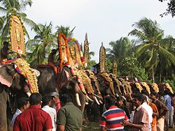
| Elephants lined up for Pooram | |
Interactive map of Chermanangad | |
| Coordinates: 10°40′55″N76°6′51″E / 10.68194°N 76.11417°E | |
| Country | |
| State | Kerala |
| District | Thrissur |
| Government | |
| • Body | Kadangode Panchayat, Vadakkanchery Block |
| Population (2011) | |
• Total | 11,060 |
| Languages | |
| • Official | Malayalam, English |
| Time zone | UTC+5:30 (IST) |
| PIN | 680604 |
| Telephone code | +914885 |
| Vehicle registration | KL-08 |
| Nearest city | Kunnamkulam, Trichur |
| Civic agency | Kadangode Panchayat, Vadakkanchery Block |
Chermanangad (also spelled Cheramanagad and Chiramanangad) is a town on the road between Kunnamkulam and Wadakanchery (Road No. SH50) in the Thrissur district of Kerala. [1]
Prehistoric burial sites, commonly known as Kodakuthy Kallu (Kudakallu) [literally meaning "stones shaped like umbrellas"], were discovered here. [2] [3] These burial sites had stones placed like umbrellas over them. These stones have been over a period of time been plundered for construction and the remaining stones shifted to museums.
These umbrella rocks of Chiramanangad are reported to have a history of over four thousand years; here people were buried in earthen urns and umbrella rocks were placed on top as landmarks.
This largely rural area is gradually being converted to a small urban centre. Agricultural activity is disappearing with agricultural land being converted to housing plots. The village centre has a temple known as Kunnambathu Kavu.
Every year Pooram is held at the village temple grounds on the 10th day of the Malayalam month Medam, approximately mid-April in the Gregorian calendar.
The nearest railway stations to Chiramanangad are in Thrissur and Wadakanchery.
The nearest major towns are Kunnamkulam and Guruvayur.
As of 2011 [update] India census, Chiramanangad had a population of 11060 with 5293 males and 5767 females. [4] [5]