Dharanikota

Last updated

Dharanikota
Dhanyakatakam
Village
State bank of India and Residential areas in Dharanikota.jpg
Residential area in Dharanikota
Nickname: 
Dhammakada
India relief location map.jpg
Red pog.svg
Dharanikota
Location in Andhra Pradesh, India
Andhra Pradesh relief map.svg
Red pog.svg
Dharanikota
Dharanikota (Andhra Pradesh)
Coordinates: 16°34′42″N80°20′54″E / 16.5783°N 80.3482°E / 16.5783; 80.3482 Coordinates: 16°34′42″N80°20′54″E / 16.5783°N 80.3482°E / 16.5783; 80.3482
Country India
State Andhra Pradesh
District Palnadu
Mandal Amaravathi mandal
Government
[1]
  Type Panchayati raj
  BodyDharanikota Gram Panchayat
Area
[2]
  Total3,548 km2 (1,370 sq mi)
Population
 (2011) [3]
  Total7,534
  Density2.1/km2 (5.5/sq mi)
Languages
  Official Telugu
Time zone UTC+5:30 (IST)
PIN
522436
Area code +91–8640
Vehicle registration AP

Dharanikota is a village in Palnadu district of the Indian state of Andhra Pradesh. It is located in Amaravathi mandal of Guntur revenue division. [2] [4] The village forms a part of Andhra Pradesh Capital Region, under the jurisdiction of APCRDA. [5]

Contents

History

In 500 BCE, Dharanikota was known as Dhanyakatakam.

Dharanikota ivory seal Dharanikota ivory seal.jpg
Dharanikota ivory seal

Archaeological excavations at Dharanikota revealed viharas in Dharanikota and nearby areas. [6] It is the site of ancient Dhanyakataka, which was the capital of the Satavahana dynasty that ruled in the Deccan around the 1st to 3rd centuries CE. It was also the capital of the Kota Vamsa, which ruled during the medieval period until the mid-12th century. The Krishna River Valley is an important rice-producing area. It was also an important centre of trade with other parts of India and foreign countries. The place is also famous for the great Amaravati stupa; a very large Kalachakra ceremony was conducted there by the Dalai Lama in January, 2006. [7] [8] Xuanzang visited Dharanikota and the Amaravati stupa and wrote an enthusiastic account of the place and the viharas that existed then.[ citation needed ] Jainism flourished in Dharanikota during the reign of Sada kings. [9]

Geography

Dharanikota is situated to the west of the mandal headquarters, Amaravathi, [10] at 16°34′46″N80°18′40″E / 16.579444°N 80.311111°E / 16.579444; 80.311111 . It is spread over an area of 1,524 ha (3,770 acres). [2]

Demographics

As of 2011 Census of India, Dharanikota had a population of 7,534. The total population constitute, 3,734 males and 3,800 females —a sex ratio of 1018 females per 1000 males. 725 children are in the age group of 0–6 years, of which 368 are boys and 357 are girls —a ratio of 970 per 1000. The average literacy rate stands at 66.06% with 4,498 literates, slightly lower than the state average of 67.41%. [3] [11]

Government and politics

Dharanikota Gram Panchayat is the local self-government of the village. [1] It is divided into wards and each ward is represented by a ward member. [12] The village is administered by the Amaravathi Mandal Parishad at the intermediate level of panchayat raj institutions. [10]

Education

As per the school information report for the academic year 2018–19, the village has a total of eight schools. These schools include five MPP and three private schools. [13]

Related Research Articles

<span class="mw-page-title-main">Amaravathi, Palnadu district</span> Village in Andhra Pradesh, India

Amaravathi is a village on the banks of the Krishna River, in the Palnadu district of the Indian state of Andhra Pradesh. It is the headquarters of Amaravathi mandal, and forms part of the Andhra Pradesh Capital Region with its headquarters at new Amaravati 35 km (22 mi) east, whose name is also borrowed from that of the older Amaravathi.

<span class="mw-page-title-main">Guntur district</span> District of Andhra Pradesh in India

Guntur district is one of the twenty six districts in the Coastal Andhra region of the Indian state of Andhra Pradesh. The administrative seat of the district is located at Guntur, the largest city of the district in terms of area and with a population of 670,073. It has a coastline of approximately 100 km (62 mi) on the right bank of Krishna River, that separates it from Krishna district and NTR district. It is bounded on the south by Bapatla district and on the west by Palnadu district. It has an area of 2,443 km2 (943 sq mi) and with a population of 20,91,075 as per 2011 census of India.

<span class="mw-page-title-main">Bhattiprolu</span> Village in Andhra Pradesh, India

Bhattiprolu is a village in Guntur district of the Indian state of Andhra Pradesh. It is the headquarters of Bhattiprolu mandal in Tenali revenue division. The Buddhist stupa in the village is one of the centrally protected monuments of national importance. One of the earliest evidence of Brahmi script in South India comes from Bhattiprolu. The script was written on an urn containing Buddha's relics. The script has been named Bhattiprolu script

Pedakakani is a village in the Guntur district of the Indian state of Andhra Pradesh. It is located in Pedakakani mandal of Guntur revenue division. Hindu shrine of Shiva, Sri Bhramaramba Malleswara Swamy Temple is located in the village.

<span class="mw-page-title-main">Attalur</span> Village in Andhra Pradesh, India

Attalur is a village in Palnadu district of the Indian state of Andhra Pradesh. It is located in Amaravathi mandal of Guntur revenue division. The village forms a part of Andhra Pradesh Capital Region, under the jurisdiction of APCRDA.

<span class="mw-page-title-main">Uppalapadu</span> Village in Andhra Pradesh, India

Uppalapadu is a village in the Guntur district of the Indian state of Andhra Pradesh. It is located in Pedakakani mandal of Guntur revenue division.

Nemalikallu is a village in Palnadu district of the Indian state of Andhra Pradesh. It is located in Amaravathi mandal of Guntur revenue division. The village forms a part of Andhra Pradesh Capital Region, under the jurisdiction of APCRDA.

Malladi is a village in Palnadu district of the Indian state of Andhra Pradesh. It is located in Amaravathi mandal of Guntur revenue division. The village forms a part of Andhra Pradesh Capital Region, under the jurisdiction of APCRDA.

<span class="mw-page-title-main">Amaravathi mandal, Andhra Pradesh</span> Mandal in Andhra Pradesh, India

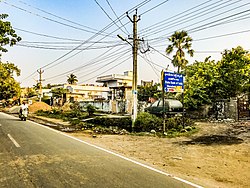
Amaravathi mandal is one of the 28 mandals in Palnadu district of the Indian state of Andhra Pradesh. It is under the administration of Sattenapalli revenue division and the headquarters are located at Amaravathi. The mandal is located on the banks of Krishna River, at a distance 27 km from the district headquarters. It is bounded by Atchampet, Krosuru, Pedakurapadu, Tadikonda and Thullur mandals.

<span class="mw-page-title-main">Endroyi</span> Village in Andhra Pradesh, India

Endroyi is a village in Guntur district of the Indian state of Andhra Pradesh. It is located in Amaravathi mandal of Guntur revenue division. The village forms a part of Andhra Pradesh Capital Region, under the jurisdiction of APCRDA.

<span class="mw-page-title-main">Penumaka</span> Village in Andhra Pradesh, India

Penumaka is a part of Mangalagiri Tadepalle Municipal Corporation part of Guntur district which is part of Andhra Pradesh. It was a village in Tadepalle mandal of Guntur district, prior to its de–notification as gram panchayat.

<span class="mw-page-title-main">Vykuntapuram</span> Village in Andhra Pradesh, India

Vykuntapuram, also spelled as Vaikuntapuram, is a village in Guntur district of the Indian state of Andhra Pradesh. It is located in Amaravathi mandal of Guntur revenue division. The village forms a part of Andhra Pradesh Capital Region, under the jurisdiction of APCRDA.

<span class="mw-page-title-main">Didugu</span> Village in Andhra Pradesh, India

Didugu is a village in Palnadu district of the Indian state of Andhra Pradesh. It is located in Amaravathi mandal of Guntur revenue division. The village forms a part of Andhra Pradesh Capital Region, under the jurisdiction of APCRDA.

Jupudi is a village in Palnadu district of the Indian state of Andhra Pradesh. It is located in Amaravathi mandal of Guntur revenue division. The village forms a part of Andhra Pradesh Capital Region, under the jurisdiction of APCRDA.

<span class="mw-page-title-main">Narukullapadu</span> Village in Andhra Pradesh, India

Narukullapadu is a village in Palnadu district of the Indian state of Andhra Pradesh. It is located in Amaravathi mandal of Guntur revenue division. Kondaveeti Vagu river flows through the village, which frequently floods causing significant damage to crops and risking lives. The village forms a part of Andhra Pradesh Capital Region, under the jurisdiction of APCRDA.

Lingapuram is a village in Palnadu district of the Indian state of Andhra Pradesh. It is located in Amaravathi mandal of Guntur revenue division. The village forms a part of Andhra Pradesh Capital Region, under the jurisdiction of APCRDA.

Vaddamanu is a village in Guntur district of the Indian state of Andhra Pradesh. It is located at a distance of 7 km from Krishna River in Thullur mandal of Guntur revenue division. The village is a part of the new capital, Amaravati.

<span class="mw-page-title-main">Pedda Madduru</span> Village in Andhra Pradesh, India

Pedamadduru is a village in Palnadu district of the Indian state of Andhra Pradesh. It is located in Amaravathi mandal of Guntur revenue division. The village forms a part of Andhra Pradesh Capital Region, under the jurisdiction of APCRDA.

<span class="mw-page-title-main">Vadlamudi</span> Village in Andhra Pradesh, India

Vadlamudi is a village in Guntur district of the Indian state of Andhra Pradesh. It is the headquarters of Chebrolu mandal in Tenali revenue division. It is located in Chebrolu mandal of Tenali revenue division.

Unguturu is a village in Palnadu district of the Indian state of Andhra Pradesh. It is located in Amaravathi mandal of Guntur revenue division. The village forms a part of Andhra Pradesh Capital Region, under the jurisdiction of APCRDA.

References

Citations

  1. 1 2 "Gram Panchayat Identification Codes" (PDF). Saakshar Bharat Mission. National Informatics Centre. p. 95. Archived from the original (PDF) on 18 August 2017. Retrieved 7 May 2019.
  2. 1 2 3 "District Census Hand Book : Guntur (Part B)" (PDF). Census of India . Directorate of Census Operations, Andhra Pradesh. 2011. pp. 14, 252. Retrieved 1 June 2019.
  3. 1 2 "Population". Census of India . Registrar General and Census Commissioner of India . Retrieved 8 May 2019.
  4. Murty, M. L. K. (2003). Pre- and Protohistoric Andhra Pradesh Up to 500 B.C. Orient Blackswan. p. 126. ISBN   9788125024750 . Retrieved 25 May 2019.
  5. "Declaration of A.P. Capital Region" (PDF). Andhra Pradesh Capital Region Development Authority . Municipal Administration and Urban Development Department, Andhra Pradesh. 30 December 2014. p. 4. Archived (PDF) from the original on 11 May 2019. Retrieved 14 May 2019.
  6. "The Buddha preached at Dharanikota". The Hindu . 25 August 2005. Archived from the original on 27 November 2014. Retrieved 6 September 2014.
  7. "On a mission for enlightenment". The Hindu . 8 January 2006. Archived from the original on 1 October 2007.
  8. Chandrakanth, W. (25 December 2005). "Amaravathi gearing for Buddhist festival". The Hindu. Archived from the original on 7 November 2012.{{cite news}}: CS1 maint: unfit URL (link)
  9. Vyas 1995, p. 31.
  10. 1 2 "District Census Handbook : Guntur (Part A)" (PDF). Census of India. Directorate of Census Operations, Andhra Pradesh. 2011. pp. 328–329. Retrieved 3 June 2019.
  11. "Literacy of AP (Census 2011)" (PDF). Official Portal of Andhra Pradesh Government. p. 43. Archived from the original (PDF) on 14 July 2014. Retrieved 5 September 2014.
  12. Seetharam, Mukkavilli (1 January 1990). Citizen Participation in Rural Development. Mittal Publications. p. 34. ISBN   9788170992271.
  13. "School Information". Commissionerate of School Education. Government of Andhra Pradesh. Retrieved 7 May 2019.

Sources