Kra Daadi district | |
|---|---|
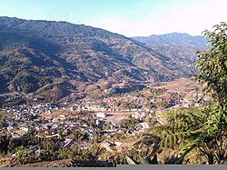 View of Palin town | |
 Location in Arunachal Pradesh | |
| Coordinates(New Palin, Arunachal Pradesh): 28°04′19″N95°19′30″E / 28.072°N 95.325°E | |
| Country | |
| State | Arunachal Pradesh |
| Division | Arunachal west |
| Headquarters | Palin |
| Government | |
| • Lok Sabha constituencies | Arunachal west |
| Area | |
• Total | 2,202 km2 (850 sq mi) |
| Elevation | 2,060 m (6,760 ft) |
| Population (2011) | |
• Total | 46,123 |
| • Density | 20.95/km2 (54.25/sq mi) |
| Demographics | |
| • Literacy | 44% |
| • Sex ratio | NA |
| Time zone | UTC+05:30 (IST) |
| PIN | 791118 |
| Website | kradaadi |
Kra Daadi district is a district in Arunachal Pradesh in north-eastern India. It was carved out of Kurung Kumey district on 7 February 2015. [1] Kra Daadi district is flanked by Tibet international border with China to the north, Upper Subansiri district to the east, Lower Subansiri district to the south, Papum Pare district to the southeast, Kurung Kumey district to the west.