Narnaul

Last updated

Narnaul
Jal Mahal of Narnaul,Haryana, India..JPG
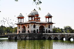
Jal Mahal of Narnaul, Haryana
India Haryana location map.svg
Red pog.svg
Narnaul
Location of Narnaul in Mahendragarh district, Haryana, India
India location map 3.png
Red pog.svg
Narnaul
Narnaul (India)
Coordinates: 28°02′40″N76°06′20″E / 28.04444°N 76.10556°E / 28.04444; 76.10556
Country Flag of India.svg  India
State Haryana
District Mahendragarh
SeatGovernment of Haryana
Elevation
318 m (1,043 ft)
Population
 (2011)
  Total145,897
Languages
  Official Hindi & English registration_plate = HR-35 xxxx (for non-commercial vehicles)
HR-66 xxxx (for commercial vehicles)
Time zone UTC+05:30 (IST)
Postal code of India
123001
Area code 01282
ISO 3166 code IN-HR
Sex ratio 901 /
Climate Cw (Köppen)
Precipitation 570 millimetres (22 in)
Avg. summer temperature38 °C (100 °F)
Avg. winter temperature04 °C (39 °F)
Website mahendragarh.gov.in

Narnaul is a city, a Municipal Council, and location of headquarters of the Mahendragarh district in the Indian state of Haryana. It is located in the National Capital Region of India.

Contents

History & etymology

Chor Gumbad at Narnaul which was made by Afghan Noble Jamal after impressed by Rao Ranmal Singh of Narnaul Chor Gumbad at Narnaul.jpg
Chor Gumbad at Narnaul which was made by Afghan Noble Jamal after impressed by Rao Ranmal Singh of Narnaul

During the early vedic period of Rigveda, this area was called the Nandigram where rishi Chyavana lived in his ashram. During the later vedic period of mahabharta, this area was called the Nara Rashtra which later became corrupted to Narnaul. During the mahabharta period, the Nara Rashtra, on the Hastinapur to Chambal route, was conquered by the youngest Pandava brother Sahdev. During medieval period, the native Nuniwal Kshatriyas ruled the area. In 1137 CE, foreign-origin muslim invader Hazrat Turkman, also known as Shah Wilayat, was killed by the native Nuniwal . [1]

Narnaul is built on a prominent tell, but the tell has never been excavated so the site's earliest history is unknown. [2] The Muslim invader Shah Wilayat came to Narnaul in 1137 CE with sword and jewels (bribes), and he was killed here by the native Nuniwal in the battle — over half a century before the Muslim conquest of Delhi. [1] [2] The dargah built for him has a coffered roof similar to early monuments at Ajmer and Bayana and may have been built during this early period. [2] Some architecture from the time of the Delhi Sultanate survives in Narnaul; the earlier phases are mostly concentrated in and around the dargah complex of Shah Wilayat, while many buildings from the Lodi dynasty are found both in Narnaul itself and on the road to Delhi. [2] These buildings are typically undated. [2]

Narnaul is likely the birthplace of the emperor Sher Shah Suri; his family is known to have had ties here for multiple generations before him. [2] After his defeat of Humayun in 1540, Sher Shah built a monumental tomb for his grandfather, Ibrahim Khan Suri, inside the dargah complex at Narnaul. [2] This tomb is built in the Lodi architectural style. [2] Later buildings from the Mughal Empire include the Jal Mahal and the octagonal tomb of Shah Quli Khan. [2] An ornate haveli, the Chhata Rai Bal Mukund Das, reflects the "Bengali" architectural style that was spread to northern India at the time of Shah Jahan and was later popular under the Rao Kings of Ahirwal. [2]

In the 1700s, Narnaul variously came under Maratha and Ahir clans control. [2] The Muslim Nawab of Narnaul took part in the Indian Rebellion of 1857 and, after its suppression, the British confiscated his lands and gave them to the Maharaja of Patiala, who had sided with them during the war. [2]

Fort

Nivajpur Fort, built by mughal jagirdar Abhay Pradhan at Nivajpur village 10 km from Narnaul, has 3 ft wide and 20 ft high stone walls. It had a system of wells, warehouses, stables and a 42 ft wide gateway, all of which now lie in ruins. [3]

Battle of Narnaul

Gopal Sagar Narnaul Gopal Sagar.jpg
Gopal Sagar Narnaul

The Battle of Narnaul (also called Battle of Nasibpur) was fought on 16 November 1857, between the British Raj and Aheer forces during the First War of Indian Independence. [4] In 1857, Aheer leader Pran Sukh Yadav of Behror along with Rao Tula Ram, the King of Rewari and Rao Dhan Singh of Charkhi Dadri fought with the British at Nasibpur village near Narnaul. The battle was one of the most ferocious battles of the First War of Indian Independence

Ajanubahu Rao Dhan Singh ji Brahman Rao of charkhi Dadri Grand Commander Sri Guru Ajanubahu Rao Dhan singh ji Brahman Rao of Charkhi Dadri.jpj.jpg
Ajanubahu Rao Dhan Singh ji Bráhman Rao of charkhi Dadri

. [5] During the Battle of Narnaul at Nasibpur on 16 November 1857, British lost 2000 British soldiers and their commanders Colonel Gerrard and Captain Wallace, 5000 British soldiers and officers Captain Craige, Captain Kennedy and Captain Pearse were wounded. Colonel Gerrard died after getting mortally wounded in a military engagement against Rao Kishan Singh. [6] [4] When Pran Sukh Yadav took aim at the Colonel Gerrard wearing a red coat whose rest of the soldiers were in khaki uniform, he missed his aim the first time but hit it right the second time and Colonel Gerard was killed in Narnaul. [7] Now mostly population are of Ahirs. [5]

Rao Kishan Singh who fought against Britishers at Nasibpur in 1857 and wounded Col Gerrad in direct conflict with only single handly defeated British contingent. Rao Kishan Singh (KrishanGopal).jpg
Rao Kishan Singh who fought against Britishers at Nasibpur in 1857 and wounded Col Gerrad in direct conflict with only single handly defeated British contingent.

Rao Krishan Gopal, from Nangal Pathani village of Gurgaon district was the Kotwal of Meerut, who had played a prominent part in collaboration with Raja Nahar Singh of Ballabhgarh, Nawab of Jhajjar, and Rao Shahamat Khan of Mewat, by organising the patriotic forces and participating in several battles against the British troops. He and his younger brother, Rao Ram Lal, were killed in this battle of Nasibpur. [8]

Geography

Narnaul is located at 28°02′N76°07′E / 28.04°N 76.11°E / 28.04; 76.11 . [9] It has an average elevation of 300 meters (977 feet). The district is rich in mineral resources such as iron ore, copper ore, beryl, tourmaline, muscovite, biotite, albite, calcite, and quartz.

Climate

In winters, the temperature can reach a low of 3 °C. In summer the highest temperature is 48.4 °C. [10]

Climate data for Narnaul (1981–2010, extremes 1965–2005)
MonthJanFebMarAprMayJunJulAugSepOctNovDecYear
Record high °C (°F)30.6
(87.1)
34.5
(94.1)
41.0
(105.8)
44.0
(111.2)
48.1
(118.6)
48.4
(119.1)
45.0
(113.0)
43.0
(109.4)
41.0
(105.8)
40.5
(104.9)
37.6
(99.7)
30.6
(87.1)
48.4
(119.1)
Mean daily maximum °C (°F)20.7
(69.3)
24.3
(75.7)
30.7
(87.3)
37.2
(99.0)
40.7
(105.3)
41.3
(106.3)
36.4
(97.5)
34.5
(94.1)
35.4
(95.7)
33.5
(92.3)
28.8
(83.8)
23.2
(73.8)
32.2
(90.0)
Mean daily minimum °C (°F)4.8
(40.6)
7.1
(44.8)
12.6
(54.7)
18.9
(66.0)
24.3
(75.7)
26.3
(79.3)
25.4
(77.7)
24.7
(76.5)
23.0
(73.4)
17.4
(63.3)
11.3
(52.3)
6.2
(43.2)
16.8
(62.2)
Record low °C (°F)0.0
(32.0)
0.1
(32.2)
2.0
(35.6)
9.8
(49.6)
11.5
(52.7)
11.0
(51.8)
17.0
(62.6)
18.6
(65.5)
14.3
(57.7)
9.3
(48.7)
0.1
(32.2)
−0.9
(30.4)
−0.9
(30.4)
Average rainfall mm (inches)13.4
(0.53)
12.2
(0.48)
8.0
(0.31)
4.7
(0.19)
34.0
(1.34)
55.2
(2.17)
149.8
(5.90)
101.3
(3.99)
30.6
(1.20)
11.1
(0.44)
2.3
(0.09)
6.5
(0.26)
429.1
(16.89)
Average rainy days0.81.20.60.52.33.36.14.81.90.90.20.422.9
Average relative humidity (%) (at 17:30 IST)47453633373955655555434546
Source: India Meteorological Department [11] [12]

Demographics

As of 2001 India census, Narnaul had a population of 74,581.Males constitute 53% of the population and females 47%. Narnaul has an average literacy rate of 68%, higher than the national average of 59.5%: male literacy is 76%, and female literacy is 58%. Narnaul having more than 70% majority as Rao Sahab also called Yadavs.In Narnaul, 14% of the population is under 6 years of age. [13]

Hindi and Ahirwati are the languages majorly spoken in Narnaul.

Schools in Narnaul

Famous Sweets And Pure Milk Products

See also

Related Research Articles

<span class="mw-page-title-main">Alwar</span> City in Rajasthan, India

Alwar is a city located in India's National Capital Region and the administrative headquarters of Alwar District in the state of Rajasthan. It is located 150 km south of Delhi and 150 km north of Jaipur. At present the district is famous for production of mustard plant, manufacturing of Ray Ban eyeglasses, Beer production plants and frozen food industry.

<span class="mw-page-title-main">Mahendragarh district</span> District in Haryana, India

Mahendragarh district is one of the 22 districts of Haryana state in northern India. The district occupies an area of 1,899 km² and has a population of 922,088 (2021census). District have 3 Sub-divisions : Narnaul, Mahendragarh and Kanina

<span class="mw-page-title-main">Loharu</span> City in Haryana, India

Loharu is a city, municipal committee and assembly constituency, near Bhiwani City in the Bhiwani district of the Indian state of Haryana. It is the administrative headquarters of one of the four administrative sub-divisions of the district and covers 119 villages. It is also a railway junction station.

Charkhi Dadri is a city and the headquarters of Charkhi Dadri district in the Indian state of Haryana, about 90 km from the national capital Delhi. The town was made by joining the villages of Charkhi and Dadri after urban development. Charkhi Dadri is on NH 148B between Narnaul to Bathinda and NH 348B between Meerut to Pilani segment passing through the city.

<span class="mw-page-title-main">Mahendragarh</span> City in Haryana, India

Mahendragarh is a city and a municipal committee in Mahendragarh district in the Indian state of Haryana. It is 100 kilometres (62 mi) from Gurgaon and comes under National Capital Region (India).

<span class="mw-page-title-main">Rewari</span> City in Haryana, India

Rewari is a city and a municipal council in Rewari district in the Indian state of Haryana. It is district headquarter of Rewari district. It is located in south-west Haryana around 82 km from Delhi and 51 km from Gurgaon. It lies in Ahirwal region.

<span class="mw-page-title-main">Rao Tula Ram</span> Indian revolutionary

Rao Tularam Singh was a Yaduvanshi Ahir King or chieftain of Rewari. He was one of the leaders of the Indian rebellion of 1857 in Haryana, where he is considered a state hero.

Tijara is a city and a municipality in Khairthal-Tijara district of the Indian state of Rajasthan. Tijara comes under the NCR area and is situated 55 km to the northeast of Alwar. The nearest railway station to Tijara is Khairthal. Bhiwadi is a census town in Tijara. It is the biggest industrial area of Rajasthan and part of the historical Ahirwal Mewat region. Tijara is dominated by Yadav and Meo community. The new political map has not erased the ancient Ahirwal-Mewat boundaries. Ahirwal was a post-Mughal principality ruled by Ahirs or Yadavs.

Kanina is a famous town and a sub division in Mahendragarh district in the Indian state of Haryana, within the National Capital Region of India.It is one of three administrative blocks of Mahendragarh district and is adjacent to Rewari, Narnaul,Charkhi Dadri, and Jhajjar. It comes in Ahirwal region. It is a municipal committee of Kanina Subdivision in Mahendragarh district.

<span class="mw-page-title-main">Dhosi Hill</span> Indian volcano and historical site

Dhosi Hill is an important Vedic period site, an extinct volcano, standing alone at the north-west end of the Aravalli mountain range. Its height varies from about 345 to 470 meters from the surrounding lands and 740 meters from the sea level. At present the hill has temples, a pakka pond, ruins of a fort, caves and forest around it. In the ancient times, as per various scriptures like Mahabharata - Vanparv, Puranas, Shathpath Brahmana etc. the hill had Ashrams of various Rishis who made contributions to Vedic scriptures.

<span class="mw-page-title-main">History of Haryana</span>

Haryana is a state in India. The state houses several sites from the Indus Valley Civilization, which was a cradle of civilization. In the Mahabharata, Haryana is mentioned as Bahudanayak Region.

<span class="mw-page-title-main">Birender Singh (politician, born 1921)</span> 2nd Chief Minister of Haryana

Maharaja Rao Birender Singh was an Indian politician. He served first as a minister in the state government of Punjab and then as Chief Minister of Haryana, and also served as a minister in Punjab state, Haryana state and the Union cabinet. He also served as the second speaker of Haryana state assembly in 1967. He coined an Indian political vocabulary Aya Ram, Gaya Ram to describe the practice of frequently floor-crossing by legislature.

Karoli is a village located in Kosli Tehsil, Rewari District, Haryana, India. It is on the 1.5-kilometre approach road boarded to Bahu-Jholri on the Kosli–Kanina road and is 12 kilometres from Kosli and 7 kilometres from Kanina. The villages is 125 kilometres from Delhi, the capital of India. It is a large village with an approximate population of 5,000 to 5,500. There is an average of one person in the army from each family. Smt. Kamala Devi is second ladies sarpanch of the village after Smt. Bhoori Devi. There are numerous temples in the village, of which that of Baba Thakur Ji and Baba Lal Das Hanuman Mandir has a special importance. All the villagers used to have dinner in the temple on Holi. The village school was earlier up to class 10 and due to excellent results in the entire district, the school has been upgraded to Senior Secondary School. The village was the birthplace of Hari Ram Arya, the Chairman of Haryana Azad Hind Fouj who participated in the Indian Independence Movement.

Aphariya (Abhirya) also spelt as Affariya, Afariya or Phariya) is a subclan of Yaduvanshi Ahirs. Aphariyas ruled the Ahirwal state of Haryana.

<span class="mw-page-title-main">Rao Gopal Dev</span> Revolutionary leader in 19th century India

Rao Gopaldev, also known as Raja Gopal Singh Yadav (1829–1862), was a nineteenth-century revolutionary leader in Rewari, Ahirwal, who allied himself with his cousin, Maharaja Rao Tula Singh Yadav, during the Indian Rebellion of 1857. He was sixth generation descendant of famous Maharaja Rao Shahbaz Singh and first cousin of Rao Tula Singh. He inherited personal jagir of 841 villages after the death of his father Raja Rao Nathu Ram in 1855. His cousin Maharaja Rao Tula Singh Made him commander in chief of Armed forces of Rewari State.

Gahra is a village in Kanina on an approach road 4 km in Mahendragarh District of Haryana State, India. It is located 47 km to the north of District headquarters Narnaul. 4 km from Kanina. 312 km from State capital Chandigarh.

<span class="mw-page-title-main">Madhogarh Fort, Haryana</span> Historic site in Haryana, India

Madhogarh Fort is a fort located on top of Madhogarh Hill in the Aravalli mountain range, near Madhogarh village, in the Mahendragarh district of Haryana state in India. It is located 12 kilometres (7.5 mi) from Mahendragarh's Satnali Chowk on SH27 Mahendragarh-Satnali-Loharu State Highway. In the Madhogarh village, there are several old havelis of interest to tourists, built in the vernacular Hindu architecture in the style of Shekhawato havelis.

Madhogarh is a village in Mahendragarh district, Haryana, India. It is located at the foot of Madhogarh Hill of Aravalli Mountain Range. Madhogarh Fort is on top of the hill.

Tourism in Haryana relates to tourism in the state of Haryana, India. There are 21 tourism hubs created by Haryana Tourism Corporation (HTC), which are located in Ambala, Bhiwani Faridabad, Fatehabad, Gurgaon, Hisar, Jhajjar, Jind, Kaithal, Karnal, Kurukshetra, Panchkula, Sirsa, Sonipat, Panipat, Rewari, Rohtak, Yamunanagar, Palwal and Mahendergarh.

<span class="mw-page-title-main">Jal Mahal (Narnaul)</span>

The Jal Mahal, also known as the Jal Mahal of Narnaul or the Water Palace, is a late 16th century palace, fortification, and artificial lake located in Narnaul, Haryana. Built by a Mughal governor of Narnaul, the structure currently serves as a tourist attraction.

References

  1. 1 2 Monuments & Sites in Haryana, Archaeological Survey Of India, page 35.
  2. 1 2 3 4 5 6 7 8 9 10 11 12 Burton-Page, J. (1993). "NĀRNAWL". In Bosworth, C.E.; van Donzel, E.; Heinrichs, W.P.; Pellat, Ch. (eds.). The Encyclopaedia of Islam, Vol. VII (MIF-NAZ). Leiden: Brill. pp. 965–6. ISBN   90-04-09419-9 . Retrieved 21 December 2022.
  3. Sohan Singh Khattar and Reena Kar, 2021, Know Your State Haryana, Arihant Publications, pp 308.
  4. 1 2 Dr Malti Malik, History of India, p. 356.
  5. 1 2 "Tribune India". 3 December 2007. Retrieved 12 October 2014.
  6. The Central India Campaign
  7. https://web.archive.org/web/20160304190735/http://www.antiquesinternational.co.uk/alwar-india-princely-state-victoria-empress-silver-one-rupee-mangal-singh-1880-2355-p
  8. 1981, Haryana Review, Volume 15, p. 29.
  9. Falling Rain Genomics, Inc - Narnaul
  10. Narnaul records lowest temperature, NDTV.
  11. "Station: Narnaul Climatological Table 1981–2010" (PDF). Climatological Normals 1981–2010. India Meteorological Department. January 2015. pp. 541–542. Archived from the original (PDF) on 5 February 2020. Retrieved 1 March 2020.
  12. "Extremes of Temperature & Rainfall for Indian Stations (Up to 2012)" (PDF). India Meteorological Department. December 2016. p. M66. Archived from the original (PDF) on 5 February 2020. Retrieved 1 March 2020.
  13. "Census of India 2001: Data from the 2011 Census, including cities, villages and towns (Provisional)". Census Commission of India. Archived from the original on 16 June 2004. Retrieved 1 November 2008.