Karnal district

Last updated

Karnal district
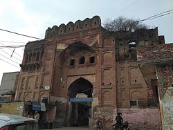
Prithviraj Chauhan' Fort-2, Taraori, Haryana.jpeg
India - Haryana - Karnal.svg
Location in Haryana
Country India
State Haryana
Division Karnal
Headquarters Karnal
Tehsils 1. Gharaunda, 2. Nilokheri, 3. Indri, 4. Karnal, 5. Assandh
Area
  Total
2,520 km2 (970 sq mi)
Population
 (2011)
  Total
1,505,324
  Density600/km2 (1,500/sq mi)
   Urban
26.51%
Demographics
   Literacy 74.73%
  Sex ratio887
Time zone UTC+05:30 (IST)
Lok Sabha constituencies Karnal (shared with Panipat district)
Vidhan Sabha constituencies 5
Website http://www.karnal.gov.in/

Karnal district is one of the 22 districts of Haryana, a state in North India which constitutes the National Capital Region (NCR) of the country. The city of Karnal is a part of the National Capital Region (NCR) and is the administrative headquarters of the district.

Contents

As it lies on National highway 44 (old NH-1), it has a well connected transport system to the nearby major cities like Delhi and Chandigarh. Karnal District is also well connected via railways. Karnal Junction lies on Delhi-Kalka line and major trains stops at this station. The district headquarter also has a small aerodrome known as karnal airport.

Sub-Divisions

The Karnal district is headed by an IAS officer of the rank of Deputy Commissioner (DC) who is the chief executive officer of the district. The district is divided into 4 sub-divisions, each headed by a Sub-Divisional Magistrate (SDM): Karnal, Indri, Assandh and Gharaunda.


Revenue tehsils

The four sub-divisions are divided into five revenue tehsils, namely Karnal, Indri, Nilokheri, Gharaunda and Assandh, and three sub-tehsils, namely Nigdhu, Nissing and Kaimla. Kaimla is the largest village in Karnal district.[ citation needed ]

Assembly constituencies

The Karnal district is divided into 5 Vidhan Sabha constituencies:

Karnal district is a part of Karnal (Lok Sabha constituency).

Demographics

Historical population
YearPop.±% p.a.
1901230,386    
1911208,536−0.99%
1921215,872+0.35%
1931221,887+0.28%
1941258,969+1.56%
1951353,764+3.17%
1961474,722+2.98%
1971619,533+2.70%
1981829,927+2.97%
19911,035,390+2.24%
20011,274,183+2.10%
20111,505,324+1.68%
source: [1]

According to the 2011 census Karnal district has a population of 1,505,324, [2] roughly equal to the nation of Gabon [3] or the US state of Hawaii. [4] This gives it a ranking of 333rd in India (out of a total of 640). [2] The district has a population density of 598 inhabitants per square kilometre (1,550/sq mi) . [2] Its population growth rate over the decade 2001-2011 was 18.22%. [2] Karnal has a sex ratio of 996 females for every 1,000 males, [2] and a literacy rate of 74.73%. Scheduled Castes made up 22.56% of the population. [2]

Religion

Religion in Karnal district (2011) [5]
ReligionPercent
Hinduism
89.08%
Sikhism
8.38%
Islam
2.10%
Other or not stated
0.44%
Religion in Karnal District
Religious
group
2011 [5]
Pop. %
Hinduism Om.svg 1,341,002
Sikhism Khanda.svg 126,207
Islam Star and Crescent.svg 31,650
Christianity Christian cross.svg 2,049
Others4,416
Total Population1,505,324
Religious groups in Karnal District (British Punjab province era)
Religious
group
1881 [6] [7] [8] 1891 [9] 1901 [10] 1911 [11] [12] 1921 [13] 1931 [14] 1941 [15]
Pop. %Pop.%Pop.%Pop.%Pop.%Pop.%Pop.%
Hinduism Om.svg [a] 453,662499,784623,597556,203573,224570,297666,301
Islam Star and Crescent.svg 156,183171,712241,412224,920235,618259,730304,346
Sikhism Khanda.svg 8,0368,03712,29413,53112,28016,92819,887
Jainism Jain Prateek Chihna.svg 4,6554,0654,7394,2134,2224,1902,789
Christianity Christian cross.svg 851201,1799203,3821,4691,249
Zoroastrianism Faravahar.svg 0010003
Buddhism Dharma Wheel (2).svg 0000000
Judaism Star of David.svg 030000
Others0000000
Total population622,621683,718883,225799,787828,726852,614994,575
Note: British Punjab province era district borders are not an exact match in the present-day due to various bifurcations to district borders — which since created new districts — throughout the historic Punjab Province region during the post-independence era that have taken into account population increases.
Religion in the Tehsils of Karnal District (1921) [13]
Tehsil Hinduism Om.svg Islam Star and Crescent.svg Sikhism Khanda.svg Christianity Christian cross.svg Jainism Jain Prateek Chihna.svg Others [b] Total
Pop. %Pop.%Pop.%Pop.%Pop.%Pop.%Pop.%
Karnal Tehsil154,96573,1992,7807239400232,607
Panipat Tehsil119,22950,6641331,2982,4720173,796
Kaithal Tehsil207,84461,4784,6061,0107840275,722
Thanesar Tehsil91,18650,2774,761351260146,601
Note: British Punjab province era tehsil borders are not an exact match in the present-day due to various bifurcations to tehsil borders — which since created new tehsils — throughout the historic Punjab Province region during the post-independence era that have taken into account population increases.
Religion in the Tehsils of Karnal District (1941) [15]
Tehsil Hinduism Om.svg [a] Islam Star and Crescent.svg Sikhism Khanda.svg Christianity Christian cross.svg Jainism Jain Prateek Chihna.svg Others [c] Total
Pop. %Pop.%Pop.%Pop.%Pop.%Pop.%Pop.%
Karnal Tehsil188,179100,9193,2911731,02114293,597
Panipat Tehsil135,55763,2544421561,03814200,461
Kaithal Tehsil241,65081,0398,4964236941332,303
Thanesar Tehsil100,91559,1347,658471360168,214
Note1: British Punjab province era tehsil borders are not an exact match in the present-day due to various bifurcations to tehsil borders — which since created new tehsils — throughout the historic Punjab Province region during the post-independence era that have taken into account population increases.

Note2: Tehsil religious breakdown figures for Christianity only includes local Christians, labeled as "Indian Christians" on census. Does not include Anglo-Indian Christians or British Christians, who were classified under "Other" category.

Languages

Languages of Karnal district (2011) [16]

   Hindi (54.28%)
   Haryanvi (32.04%)
   Punjabi (10.86%)
   Saraiki (1.06%)
  Others (1.76%)

At the time of the 2011 Census of India, 54.28% of the population in the district spoke Hindi, 32.04 Haryanvi, 10.86% Punjabi and 1.06% Saraiki as their first language. [16]

People from Karnal District

See also

Notes

  1. 1 2 1931-1941: Including Ad-Dharmis
  2. Including Buddhism, Zoroastrianism, Judaism, Tribals, others, or not stated
  3. Including Anglo-Indian Christians, British Christians, Buddhism, Zoroastrianism, Judaism, Tribals, others, or not stated

Related Research Articles

<span class="mw-page-title-main">Haripur, Pakistan</span> City in Khyber Pakhtunkhwa, Pakistan

Haripur is a city in the Hazara Division of Khyber Pakhtunkhwa province, Pakistan. It is the 14th largest city by population in the province, and serves as the headquarter of its namesake tehsil and district. Located some 65 km (40 mi) north of Islamabad Capital Territory and 35 km (22 mi) south of Abbottabad, Haripur is in a hilly plain area at an altitude of 520 m (1,706 ft).

<span class="mw-page-title-main">Rohtak district</span> District of Haryana in India

Rohtak district is a district in the Indian state of Haryana. It is located in the southeast of the state and northwest of Delhi, bounded by Jind and Sonipat districts to the north, Jhajjar and Sonipat districts to the east, and Hissar, Charkhi Dadri, and Bhiwani districts to the west. Rohtak city is the district headquarters.

<span class="mw-page-title-main">Malerkotla</span> City in Punjab, India

Malerkotla is a city and the district headquarters of Malerkotla district in the Indian state of Punjab. It served as the seat of the eponymous princely state during the British Raj. The state acceded to the union of India in 1947 and was merged with other nearby princely states to form the Patiala and East Punjab States Union (PEPSU).

<span class="mw-page-title-main">Jind district</span> District of Haryana in India

Jind district is one of the 22 districts of Haryana state in northern India. Jind town is the administrative headquarters of the district. It is part of Hisar Division and was created in 1966.

<span class="mw-page-title-main">Hisar district</span> District of Haryana in India

Hisar district is one of the 22 districts of Haryana, India. Hisar city serves as the district headquarters. Hisar district has four sub-divisions that is, Hisar, Barwala, Hansi and Narnaud, each headed by an SDM. The district is also part of Hisar division. Hisar was founded by Firuz Shah Tughlaq.

<span class="mw-page-title-main">Hoshiarpur</span> City in Punjab, India

Hoshiarpur is a city and a municipal corporation in Hoshiarpur district in the Doaba region of the Indian state of Punjab. It was founded, according to tradition, during the early part of the fourteenth century. In 1809, it was occupied by the forces of Maharaja Karanvir Singh and was united into the greater state of Punjab in 1849.

<span class="mw-page-title-main">Jhang</span> City in Punjab, Pakistan

Jhang is the capital city of Jhang District in central Punjab, Pakistan. Situated on the east bank of the Chenab river, it is the 13th most populous city of Pakistan.

<span class="mw-page-title-main">Punjab Province (British India)</span> Province of British India

The Punjab Province was a province of British India. Most of the Punjab region was annexed by the British East India Company on 29 March 1849; it was one of the last areas of the Indian subcontinent to fall under British control. In 1858, the Punjab, along with the rest of British India, came under the rule of the British Crown. It had a land area of 358,355 square kilometers.

<span class="mw-page-title-main">Gurgaon district</span> District in Haryana, India

Gurgaon district, officially known as Gurugram district, is one of the 22 districts of Haryana in northern India. The city of Gurgaon is the administrative headquarters of the district. The population is 1,514,432. It is one of the southern districts of Haryana. On its north, it is bounded by the district of Jhajjar and the Union Territory of Delhi. Faridabad district lies to its east. To its south lie the districts of Palwal and Nuh. To the west lies Rewari district.

<span class="mw-page-title-main">Ambala district</span> District of Haryana in India

Ambala district is one of the 22 districts of Haryana state in the country of India with Ambala town serving as the administrative headquarters of the district. District Ambala lies on the North-Eastern edge of Haryana and borders Punjab and Himachal Pradesh. Ambala district is a part of Ambala Division.

<span class="mw-page-title-main">Chakwal</span> Town in Punjab, Pakistan

Chakwal is a city in Chakwal District in the Potohar region of Punjab, Pakistan.

<span class="mw-page-title-main">East Punjab</span> Former province of India from 1947 to 1950

East Punjab was a province of India from 1947 until 1950. It consisted parts of the Punjab province that remained in India following the partition of the province between the new dominions of Pakistan and the Indian Union by the Radcliffe Commission in 1947. The mostly Muslim western parts of the old Punjab became Pakistan's West Punjab, later renamed as Punjab Province, while the mostly Hindu and Sikh eastern parts remained with India.

Nawan Shehr is a town in Abbottabad District, Khyber Pakthunkhwa, Pakistan. The town is renowned for the historic Ilyasi Masjid, the largest and oldest mosque of Abbottabad. Behind the mosque lies a small hill with walking trails, adding to the town's scenic charm. During the summer, Nawan Shehr attracts visitors from across the country due to its pleasant climate. It is also home to educational institutions of the Board of Intermediate and Secondary Education. Nawan Shehr has its own old bazaar which is famous for its Chapli Kebab. The primary language spoken is Hindko, with Gojri also spoken in some areas. Nawan Shehr is located on the route to Abbottabad City and the tourist destinations of Thandiani and Nathia Gali along Murree Road, at an elevation of 1,216 meters.

<span class="mw-page-title-main">Peshawar Division</span> Administrative division of Khyber Pakhtunkhwa, Pakistan

Peshawar Division is an administrative division of Khyber Pakhtunkhwa Province, Pakistan. It was abolished in the reforms of 2000, like all divisions, but reinstated in 2008. At independence in 1947, the Khyber Pakhtunkhwa was split into two divisions, Dera Ismail Khan and Peshawar. Until 1976, Peshawar Division contained the districts of Hazara and Kohat, when they both became divisions themselves. Later in the mid-1990s, the district of Mardan also became a division itself. CNIC code of Peshawar Division is 17.

<span class="mw-page-title-main">Kalsia</span> Sikh state

Kalsia was a princely state in Punjab, British India, one of the former Cis-Sutlej states. It was founded by Gurbaksh Singh Kalsia in 1760. After India's independence, it was included in PEPSU and later in the Indian East Punjab after the States Reorganisation Act, 1956. The area of Kalsia is now located in the modern day Indian states of Punjab and Haryana. In 1940 the population of Kalsia was 67,393. Kalsia was ruled by Jat Sikhs.

Religion in the Punjab in ancient history was characterized by Hinduism and later conversions to Jainism, Buddhism, Islam, Sikhism and Christianity; it also includes folk practices common to all Punjabis regardless of the religion they adhere to. Such practices incorporate local mysticism, including ancestral worship and worship of local saints of all faiths.

<span class="mw-page-title-main">Jainism in Pakistan</span>

Jainism in Pakistan has an extensive heritage and history, with several ancient Jain shrines scattered across the country. Baba Dharam Dass was a holy man whose tomb is located near the bank of a creek called near Chawinda Phatic, behind the agricultural main office in Pasrur, near the city of Sialkot in Punjab, Pakistan. Another prominent Jain monk of the region was Vijayanandsuri of Gujranwala, whose samadhi still stands in the city.

<span class="mw-page-title-main">Loharu State</span> Princely state of India

Loharu State was one of the princely states of India during the period of the British Raj. It was part of the Punjab States Agency and was a nine-gun salute state.

<span class="mw-page-title-main">Islam in Punjab, India</span> Overview of the Role and Impact of Islam in Punjab, India

Islam is a minority religion in Punjab, India followed by 535,489 people constituting about 1.93 percent of the state population out of 27.7 million population as of 2011 census report.

Dujana is a village, formerly a princely state, in Beri tehsil of Jhajjar district of Haryana State, India. The village is administered by a Sarpanch, an elected representative of the village.

References

  1. Decadal Variation In Population Since 1901
  2. 1 2 3 4 5 6 "District Census 2011". Census2011.co.in. 2011. Retrieved 30 September 2011.
  3. US Directorate of Intelligence. "Country Comparison:Population". Archived from the original on 13 June 2007. Retrieved 1 October 2011. Gabon 1,576,665
  4. "2010 Resident Population Data". U. S. Census Bureau. Archived from the original on 1 January 2011. Retrieved 30 September 2011. Hawaii 1,360,301
  5. 1 2 "Table C-01 Population by Religion: Haryana". censusindia.gov.in. Registrar General and Census Commissioner of India.
  6. "Census of India, 1881 Report on the Census of the Panjáb Taken on the 17th of February 1881, vol. I." 1881. JSTOR   saoa.crl.25057656 . Retrieved 26 December 2024.
  7. "Census of India, 1881 Report on the Census of the Panjáb Taken on the 17th of February 1881, vol. II". 1881. p. 14. JSTOR   saoa.crl.25057657 . Retrieved 26 December 2024.
  8. "Census of India, 1881 Report on the Census of the Panjáb Taken on the 17th of February 1881, vol. III". 1881. p. 14. JSTOR   saoa.crl.25057658 . Retrieved 26 December 2024.
  9. "The Punjab and its feudatories, part II--Imperial Tables and Supplementary Returns for the British Territory". 1891. p. 14. JSTOR   saoa.crl.25318669 . Retrieved 26 December 2024.
  10. "Census of India 1901. [Vol. 17A]. Imperial tables, I-VIII, X-XV, XVII and XVIII for the Punjab, with the native states under the political control of the Punjab Government, and for the North-west Frontier Province". 1901. p. 34. JSTOR   saoa.crl.25363739 . Retrieved 17 March 2024.
  11. "Census of India 1911. Vol. 14, Punjab. Pt. 2, Tables". 1911. p. 27. JSTOR   saoa.crl.25393788 . Retrieved 17 March 2024.
  12. Kaul, Harikishan (1911). "Census Of India 1911 Punjab Vol XIV Part II". p. 27. Retrieved 17 March 2024.
  13. 1 2 "Census of India 1921. Vol. 15, Punjab and Delhi. Pt. 2, Tables". 1921. p. 29. JSTOR   saoa.crl.25430165 . Retrieved 17 March 2024.
  14. "Census of India 1931. Vol. 17, Punjab. Pt. 2, Tables". 1931. p. 277. JSTOR   saoa.crl.25793242 . Retrieved 17 March 2024.
  15. 1 2 India Census Commissioner (1941). "Census of India, 1941. Vol. 6, Punjab". p. 42. JSTOR   saoa.crl.28215541 . Retrieved 17 March 2024.
  16. 1 2 "Table C-16 Population by Mother Tongue: Haryana". Census of India . Registrar General and Census Commissioner of India..
  17. "Only 98 cities instead of 100 announced: All questions answered about the smart cities project". 28 August 2015.

29°40′N76°50′E / 29.667°N 76.833°E / 29.667; 76.833