Jind district

Last updated

Jind district
6tag 300317-194515.jpg
Rani Talab in Bhuteshwar Temple, Jind
India - Haryana - Jind.svg
Location in Haryana
Country India
State Haryana
Division Hisar
Headquarters Jind
Tehsils 1. Jind 2. Julana 3. Narwana 4. Safidon 5.Uchana
Area
  Total
2,702 km2 (1,043 sq mi)
Population
 (2011)
  Total
1,334,152
  Density490/km2 (1,300/sq mi)
Demographics
   Literacy 72.7%
Time zone UTC+05:30 (IST)
Average annual precipitation434 mm
Lok Sabha constituencies 1. Sonipat (shared with Sonipat district), 2, Hisar (shared with Hisar district), 3. Sirsa (shared with Sirsa district)
Vidhan Sabha constituencies 5
Website http://jind.nic.in/

Jind district is one of the 22 districts of Haryana state in northern India. Jind town is the administrative headquarters of the district. It is part of Hisar Division and was created in 1966.

Contents

Etymology

The district derives its name from its headquarters town Jind that is said to be derived from Jaintapuri. It is also said that this town had been founded at the time of the Mahabharata. According to a legend, the Pandavas built a temple in honour of Jainti Devi (the goddess of victory), offered prayers for success, and then launched the battle with the Kauravas. The town grew up around the temple and was named Jaintapuri (Abode of Jainti Devi) which later on came to be known as Jind.

History

Historical population
YearPop.±% p.a.
1951351,651    
1961467,416+2.89%
1971636,428+3.13%
1981796,902+2.27%
1991980,434+2.09%
20011,189,827+1.95%
20111,334,152+1.15%
source: [1]

Jind Fort

Raja Gajpat Singh, a great-grandson of Chaudhary Phul Singh Sidhu Jat, the founder of the Phulkian Misl, established a kingdom by seizing a large tract of the country, which included the territory occupied by the present district of Jind, from the Afghan governor Zain Khan in 1763 and created Jind city, the capital of the state in 1776. He built a fort here in 1775. Later, Sangrur was chosen as the capital of Jind State by Raja Sangat Singh (reigned 1822 to 1834).

The Raja of Jind is of the same family as the Maharaja of Patiala, being like him, descended from Phul.

The Originator of the Phulkian Dynasty, Phul left six sons, of whom Tiloka was the eldest, and from him are descended the families of Jind and Nabha.

From Rama, the second son, sprang the greatest of the Phulkian houses, that of Patiala besides Bhadaur, Kot Duna and Malaudh.

In 1627 Phul founded and gave his name to a village which was an important town in the State of Nabha. His two elder sons founded Bhai Rupa while Rama also built Rampura Phul.

Punjab history reveals that Jind was founded by descendants of Phool. Jind was a native state in Haryana. Jind was a state of Siddus founded by the grandson of Chaudhary Phul Singh.

Tiloka had two sons namely, 1. Gurudutta 2. Sukh Chain. Sukh Chain's descendants ruled Jind state and Gurudatta's descendants ruled Nabha state.

Post-Independence after 1947

After Independence, Jind and Patiala States were merged into the Indian Union on 15 July 1948, the Jind Tahsil of Jind State and mostly Narwana Tahsil of Patiala State were reorganized to form two new tahsils: Jind and Narwana in Sangrur district, which became part of the newly formed Patiala and East Punjab States Union (PEPSU).

During the reorganization of Punjab on 1 November 1966, Sangrur district was divided, and the Jind and Narwana tahsils were transferred to the newly created state of Haryana. These tahsils were combined to form the new Jind district, one of the seven original districts of Haryana. In 1967, Jind Tahsil was further split into two separate tahsils: Jind and Safidon.

In January 1973, 54 villages were transferred from Kaithal Tahsil of Karnal district to Jind district—43 to Jind, 5 to Safidon, and 6 to Narwana Tahsil. In 1974, the village of Barsola was also added to Jind Tahsil from Hansi Tahsil in Hisar district. [2]

Divisions

The district comprises three sub-divisions: Jind, Narwana and Safidon. Jind sub-division is further divided into three tehsils: Jind, Julana and Alewa (sub-tehsil). Narwana sub-division is further divided into two tehsils: Narwana and Uchana (sub-tehsil), and Safidon sub-division is also divided into two tehsils: Safidon and Pillu-Khera (sub-tehsil).

There are five Vidhan Sabha constituencies in this district: Jind, Julana, Safidon, Uchana Kalan and Narwana. Jind, Julana and Safidon are part of Sonipat Lok Sabha constituency. Narwana and Uchana Kalan are part of Sirsa and Hisar Lok Sabha constituencies respectively. [3]

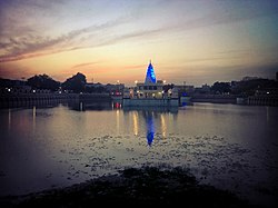
Jind town, the administrative headquarters, has an Arjun stadium, milk plant, cattle feed plant, and a large grain market. There are facilities for stay at PWD rest house, canal rest house, and market committee rest house. The town is well provided with schools, colleges, hospitals, and other basic amenities. Jind is noted for its numerous temples sacred to the worship of Shiva. Tradition assigns the settlement of the town to the Mahabharat period. Rani Talab is the major tourist attraction and Pandu-Pidara and Ramrai are the main devotional places attracting devotees for Amaavas bath.

Demographics

According to the 2011 census Jind district has a population of 1,334,152, [4] roughly equal to the nation of Mauritius [5] or the US state of Maine. [6] This gives it a ranking of 364th in India (out of a total of 640). [4] The district has a population density of 493 inhabitants per square kilometre (1,280/sq mi). [4] Its population growth rate over the decade 2001-2011 was 11.95%. [4] Jind has a sex ratio of 870 females for every 1000 males, [4] and a literacy rate of 72.7%. Scheduled Castes make up 21.16% of the population. [4]

Religion

Religious groups in Jind District (British Punjab province era)
Religious
group
1881 [7] [8] [9] 1891 [10] 1901 [11] 1911 [12] [13] 1921 [14] 1931 [15] 1941 [16]
Pop. %Pop.%Pop.%Pop.%Pop.%Pop.%Pop.%
Hinduism Om.svg [a] 210,627230,846211,963210,222234,721243,561268,355
Islam Star and Crescent.svg 34,24738,50838,71737,52043,25146,00250,972
Sikhism Khanda.svg 4,33515,02029,97522,56628,02633,29040,981
Jainism Jain Prateek Chihna.svg 6491731,2581,2331,5481,6131,294
Christianity Christian cross.svg 3780187637210161
Zoroastrianism Faravahar.svg 0000003
Buddhism Dharma Wheel (2).svg 0000003
Judaism Star of David.svg 600000
Others101000043
Total population249,862284,560282,003271,728308,183324,676361,812
Note1: British Punjab province era district borders are not an exact match in the present-day due to various bifurcations to district borders — which since created new districts — throughout the historic Punjab Province region during the post-independence era that have taken into account population increases.
Note 2: British Punjab province era figures refer to Jind State. Relative to present-day Jind district, the state excluded areas of contemporary Narwana tehsil but included Charkhi Dadri district along with some parts of contemporary Sangrur district, Bathinda district, and Patiala district.
Religion in Jind district (2011) [17]
ReligionPercent
Hinduism
95.69%
Sikhism
2.18%
Islam
1.73%
Other or not stated
0.40%
Religious groups in Jind District (Modern era)
Religious
group
1971 [18]
Pop. %
Hinduism Om.svg 6,11,57395.62%
Sikhism Khanda.svg 15,9972.5%
Islam Star and Crescent.svg 7,6501.2%
Jainism Jain Prateek Chihna.svg 4,2300.66%
Others [b] 820.1%
Total population639,610

Languages

Languages of Jind district (2011) [19]
  1. Haryanvi (84.07%)
  2. Hindi (12.41%)
  3. Punjabi (2.8%)
  4. Others (0.72%)

See also

Notes

  1. 1931-1941: Including Ad-Dharmis
  2. Including Buddhism, Zoroastrianism, Jews

References

  1. Decadal Variation In Population Since 1901
  2. History of Jind District gov
  3. "Delimitation of Parliamentary and Assembly Constituencies Order, 2008" (PDF). The Election Commission of India. pp. 151, 157.
  4. 1 2 3 4 5 6 "District Census 2011". Census2011.co.in. 2011. Retrieved 30 September 2011.
  5. US Directorate of Intelligence. "Country Comparison:Population". Archived from the original on 13 June 2007. Retrieved 1 October 2011. Mauritius 1,303,717 July 2011 est.
  6. "2010 Resident Population Data". U. S. Census Bureau. Archived from the original on 19 October 2013. Retrieved 30 September 2011. Maine 1,328,361
  7. "Census of India, 1881 Report on the Census of the Panjáb Taken on the 17th of February 1881, vol. I." 1881. JSTOR   saoa.crl.25057656 . Retrieved 26 December 2024.
  8. "Census of India, 1881 Report on the Census of the Panjáb Taken on the 17th of February 1881, vol. II". 1881. p. 14. JSTOR   saoa.crl.25057657 . Retrieved 26 December 2024.
  9. "Census of India, 1881 Report on the Census of the Panjáb Taken on the 17th of February 1881, vol. III". 1881. p. 14. JSTOR   saoa.crl.25057658 . Retrieved 26 December 2024.
  10. "The Punjab and its feudatories, part II--Imperial Tables and Supplementary Returns for the British Territory". 1891. p. 14. JSTOR   saoa.crl.25318669 . Retrieved 26 December 2024.
  11. "Census of India 1901. [Vol. 17A]. Imperial tables, I-VIII, X-XV, XVII and XVIII for the Punjab, with the native states under the political control of the Punjab Government, and for the North-west Frontier Province". 1901. p. 34. JSTOR   saoa.crl.25363739 . Retrieved 30 March 2024.
  12. "Census of India 1911. Vol. 14, Punjab. Pt. 2, Tables". 1911. p. 27. JSTOR   saoa.crl.25393788 . Retrieved 30 March 2024.
  13. Kaul, Harikishan (1911). "Census Of India 1911 Punjab Vol XIV Part II". p. 27. Retrieved 30 March 2024.
  14. "Census of India 1921. Vol. 15, Punjab and Delhi. Pt. 2, Tables". 1921. p. 29. JSTOR   saoa.crl.25430165 . Retrieved 30 March 2024.
  15. "Census of India 1931. Vol. 17, Punjab. Pt. 2, Tables". 1931. p. 277. JSTOR   saoa.crl.25793242 . Retrieved 30 March 2024.
  16. "Census of India, 1941. Vol. 6, Punjab". 1941. p. 42. JSTOR   saoa.crl.28215541 . Retrieved 30 March 2024.
  17. "Table C-01 Population by Religion: Haryana". censusindia.gov.in. Registrar General and Census Commissioner of India.
  18. "Social and Cultural Tables & Special Tables on Scheduled Castes and Scheduled Tribes, Part II-C (i), Part V-A, Series-6, Haryana - Census 1971". Census Digital Library. p. 12. Retrieved 5 January 2025.
  19. 1 2 "Table C-16 Population by Mother Tongue: Haryana". Census of India . Registrar General and Census Commissioner of India..

29°18′36″N76°19′12″E / 29.31000°N 76.32000°E / 29.31000; 76.32000