Patiala and East Punjab States Union

Last updated

Patiala and East Punjab States Union
State of India
1948–1956
PEPSU in India (1951).svg
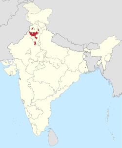
1951 map of India. The Patiala and East Punjab States Union is shown forming enclaves in East Punjab.
Capital Patiala
Area 
 1951
26,208 km2 (10,119 sq mi)
Population 
 1951
3,493,685
  TypeDemocracy
Legislature Patiala and East Punjab States Union Legislative Assembly
History 
 State Established
15 July 1948
 State Disestablished
1 November 1956
Preceded by
Succeeded by
Blank.png Punjab States Agency
Punjab Blank.png
Chandigarh Blank.png
Haryana Blank.png
Himachal Pradesh Blank.png
Today part ofFlag of India.svg India

The Patiala and East Punjab States Union (PEPSU) was a State of India, uniting eight Princely states between 1948 and 1956. The capital and principal city was Patiala. The state covered an area of 26,208 km2.Kasauli, Kandaghat and Chail was also part of PEPSU.

Contents

History

Princely states union

It was created by combining eight princely states (7 Punjab State & 1 Punjab Hill State) , which maintained their native rulers :

Six Salute states
and two Non-salute states

The state was inaugurated on 15 July 1948 and formally became a state of India in 1950.

Successor states

PEPSU state in East Punjab Punjab 1951-66.svg
PEPSU state in East Punjab

On 1 November 1956, PEPSU was merged mostly into Punjab State following the States Reorganisation Act. [1]

A part of the former state of PEPSU, including the present day Jind district(Jind & Narwana), Area of Pinjore in north Haryana, as well as the Charkhi Dadri , Bawal and Mahendragarh Narnaul in south-west Haryana, presently lie within the state of Haryana, which was separated from Punjab on 1 November 1966. Some other areas that belonged to PEPSU, notably ( kandaghat etc.) Solan and Nalagarh, now lie in the state of Himachal Pradesh.

Rajpramukh and Uparajpramukh

S. no.RajpramukhPortraitTenureUparajpramukhPortraitAppointed by
1 Yadavindra Singh Yadvinder Singh Mahendra Bahadur (1971).jpg 15 July 19481 November 19568 years, 109 days Jagatjit Singh Maharaja de kapurthala jagatjit singh.jpg C. Rajagopalachari

Chief Ministers

NoPortraitName

(Birth–Death)
(Constituency)

Term of officeTime in officeParty
(Alliance/ Partner)
Assembly
(Election)
Appointed by
Took officeLeft office
Premier (1948–1952)
- Gian Singh Rarewala ex CM.png Gian Singh Rarewala
(1901-1979)
( – )
15 July 194813 January 1949182 days IND Not Yet Created Yadavindra Singh
1 Gian Singh Rarewala ex CM.png Gian Singh Rarewala
(1901-1979)
( – )
13 January 194923 May 19512 years, 130 days
2 Col. Raghbir Singh.jpg Raghbir Singh
(1895-1955)
( – )
23 May 195121 April 19521 year, 333 days Indian National Congress
Chief Minister (1952–1956)
1 Col. Raghbir Singh.jpg Raghbir Singh
(1895-1955)
(Patiala Sadar)
21 April 195222 April 19521 day Indian National Congress 1st
(1952)
Yadavindra Singh
2 Gian Singh Rarewala ex CM.png Gian Singh Rarewala
(1901-1979)
(Amloh)
22 April 19525 March 1953317 days IND
(UDF)
(i) Emblem of India.svg Vacant [a]
(President's rule)
5 March 19538 March 19541 year, 3 days- Rajendra Prasad
(1) Col. Raghbir Singh.jpg Raghbir Singh
(1895-1955)
(Patiala Sadar)
8 March 195412 January 1955 [d] 310 days Indian National Congress 2nd
(1954)
Yadavindra Singh
3 Brish Bhan.png Brish Bhan
(1908-1988)
(Kalayat)
12 January 19551 November 1956 [pd] 1 year, 294 days

Deputy Chief Minister

Sr. No.NamePortraitTerm of officePolitical PartyChief Minister
1 Brish Bhan Brish Bhan.png 23 May 195121 April 1952 Indian National Congress Raghbir Singh
8 March 195412 January 1955

Institutions

Patiala and East Punjab States Union (PEPSU) coat of arms in the inauguration stone of Government Medical College, Patiala Patiala and East Punjab States Union - PEPSU logo.jpg
Patiala and East Punjab States Union (PEPSU) coat of arms in the inauguration stone of Government Medical College, Patiala

Heads of state and government

When the state was formed, the then-Maharaja of Patiala, Yadavindra Singh, was appointed its Rajpramukh (equivalent to Governor). He remained in office during the entire length of the state's short existence. The then Maharaja of Kapurthala, Jagatjit Singh, served as Uparajpramukh (lieutenant-governor).[ citation needed ]

Gian Singh Rarewala was sworn in on 13 January 1949 as the first Chief Minister of PEPSU. Col. Raghbir Singh became the next Chief Minister on 23 May 1951, and Brish Bhan the Deputy Chief Minister. [3]

The state elected a 60-member state legislative assembly on 6 January 1952. The Congress Party won 26 seats and the Akali Dal won 19 seats.

On 22 April 1952, Gian Singh Rarewala again became Chief Minister, this time an elected one. He led a coalition government, called the "United Front", formed by the Akali Dal and various independents. On 5 March 1953 his government was dismissed and President's rule was imposed on the state. [4] In the mid-term poll that followed, the Congress party secured a majority and Raghbir Singh became Chief Minister on 8 March 1954. Upon his death, Brish Bhan became the Chief Minister on 12 January 1955 and remained in office as last incumbent.[ citation needed ]

Administration

Initially, in 1948, the state was divided into the following eight districts & 25 sub-district (tahsils): [5]

  1. Patiala - Patiala, Nabha, Rajpura
  2. Kapurthala - kapurthala, Phagwara
  3. Bathinda - Bathinda, Mansa, Faridkot
  4. Fatehgarh Sahib - Sirhand, Payal, Amloh
  5. Barnala - Barnala, Phul, Dhuri, Malerkotla
  6. Sangrur - Sangrur, Sunam, Narwana, Jind
  7. Kohistan - Kandaghat, Nalagarth, Dera Bassi
  8. Mohindergarh - Mohindergarh, Narnaul, Dadri

In 1953, the number of districts in PEPSU was reduced from eight to five. Fatehgarh Sahib and Kohistan districts were dissolved and merged with Patiala district. Amloh and Payal tehsils of Fatehgarh Sahib were merged with Sirhind tehsil, while Dera Bassi tehsil of Kohistan district was merged with Rajpura tehsil. Barnala district was also abolished. It had four tehsils: Phul, Dhuri, Malerkotla, and Barnala. Dhuri, Malerkotla, Barnala, and part of Phul tehsil were transferred to Sangrur district, while the remaining portion of Phul tehsil was merged with Bhatinda district. [6] [7]

There were four Lok Sabha constituencies in this state. Three of them were single-seat constituency: Mohindergarh, Sangrur and Patiala. The Kapurthala-Bhatinda Lok Sabha constituency was a double-seat constituency.

Demography

The state had a population of 3,493,685 (1951 census), of which 19% was urban. The population density was 133/km2. [8] The state had 64 towns and 5,708 villages. [5]

Notes

  1. President's rule may be imposed when the "government in a state is not able to function as per the Constitution", which often happens because no party or coalition has a majority in the assembly. When President's rule is in force in a state, its council of ministers stands dissolved. The office of chief minister thus lies vacant, and the administration is taken over by the governor, who functions on behalf of the central government. At times, the legislative assembly also stands dissolved. [2]

References

  1. "States Reorganisation Act, 1956". India Code Updated Acts. Ministry of Law and Justice, Government of India. 31 August 1956. pp. section 9. Retrieved 16 May 2013.
  2. Amberish K. Diwanji. "A dummy's guide to President's rule". Rediff.com. 15 March 2005.
  3. "Research Centre for Technical Development of Punjabi Language, Literature and Culture, Punjabi University, Patiala". Punjabi University. Retrieved 27 February 2024.
  4. Singh, Roopinder (16 December 2001). "Rarewala: A Punjabi-loving gentleman-aristocrat". The Tribune .
  5. 1 2 Page no. iii & iv - Punjab, India Census book part I-A report 1951
  6. History of jind district nic.in or Archived
  7. Page no. 10 - Punjab, india Census book Part II-A general population tables 1961 or Page no. 66 - Census book Part I-A Punjab
  8. "Patiala and East Punjab States Union". The Sikh Encyclopedia. Archived from the original on 21 August 2017. Retrieved 11 November 2016.

Further reading

  1. Singh, Gursharan (1991). History of PEPSU, India: Patiala and East Punjab States Union, 1948-1956, Delhi: Konark Publishers, ISBN   81-220-0244-7.

31°27′N77°36′E / 31.45°N 77.60°E / 31.45; 77.60