Kuthar

Last updated

Entrance of the palace of Kuthar Princely State, Himachal Pradesh, India Entrance of palace of Kuthar Princely State,Himachal Prades,India.jpg
Entrance of the palace of Kuthar Princely State, Himachal Pradesh, India
Palace of erstwhile Princely State Kuthar, Himachal Pradesh, India Palace of erstwhile Princely State Kuthar,India 01.jpg
Palace of erstwhile Princely State Kuthar, Himachal Pradesh, India

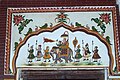
Kuthar, formerly Krishangarh, is located in the Solan district of Himachal Pradesh. Krishangarh (Kuthar) is situated on the MDR-75 i.e. Shalaghat-Arki-Kunihar-Kuthar-Patta-Brotiwala (previously known as State Highway-9) adjoining Sabathu, Kasauli area. Krishangarh is an administrative division of Solan district having sub-tehsil status.

Contents

History

Kuthar was a princely state of the British Raj, located in modern-day Himachal Pradesh. It was one of the several states of the Punjab States Agency.

The state of Kuthar was founded in the 17th century. It was occupied by Nepali forces during drive of Himalayas from 1803 to 1815.

Rulers

The rulers bore the title of rana. [1] [2]

See also

  1. http://www.worldstatesmen.org/India_princes_K-W.html
  2. https://masalamug.com/kuthar-hideout-in-himachal/


Related Research Articles

<span class="mw-page-title-main">Bushahr</span> Princely state during British Raj

Bushahr, also spelt as 'Bashahr' and 'Bussahir' or 'Bushair' was a Rajput princely state in India during the British Raj. It was located in the hilly western Himalaya promontory bordering Tibet in the northern part of colonial Punjab region.

<span class="mw-page-title-main">Nalagarh</span> City in Himachal Pradesh, India

Nalagarh is a city and a municipal committee, near the city of Solan in Solan district in the Indian state of Himachal Pradesh.

<span class="mw-page-title-main">Baghal State</span>

Baghal was one of the Princely states of India during the period of the British Raj. It covers an area of 312 square kilometres (120 sq mi) and is now part of Arki Tehsil in Solan District of Himachal Pradesh state. Baghal was founded by Rana Aje De in 1310-40 and was acceded to India on 15 April 1948.

<span class="mw-page-title-main">Bilaspur State (princely state)</span> Princely state of British India

Bilaspur State or Kahlur State, sometimes Kahloor Riyasat, was a kingdom (697-1849) and later princely state (1849-1948) in the Punjab Province ruled by a separate branch of Chandravanshi Chandel dynasty. Raja Bir Chand 697-730 was the founder of the state but it was named Kahlur only after the Construction of Kahlur Fort by Raja Kahal Chand around 890-930CE and Raja Anand Chand the 44th Raja was the last ruler.

Katoch is a Chandravanshi Rajput clan. Their traditional area of residence was in the Trigarta Kingdom, based at Jalandhar and at Kangra Fort in the Indian state of Himachal Pradesh. They descent from the Trigarta dynasty mentioned in the Mahabharata. Famous subclans came into existence from Katoch Rajputs are Dadwal Dynasty, Guleria Dynasty, Sibaia Dynasty, Chib Dynasty, Jaswal Dynasty.

Keonthal State, covering an area of 482 km2, was one of the Princely states of India during the period of the British Raj. Its capital was Junga. Keonthal acceded to India on 15 April 1948. Currently, it is part of the Indian state of Himachal Pradesh.

<span class="mw-page-title-main">Arki, India</span> Town in Himachal Pradesh, India

Arki is a town, tehsil and Nagar panchayat in Solan district of Himachal Pradesh, India. The town is known for its fort built in the late 18th century when Arki was the capital of the erstwhile princely hill state of Baghal.

<span class="mw-page-title-main">Arki Fort</span>

Arki palace is located in Arki, India, a town in Himachal Pradesh.

<span class="mw-page-title-main">Dhami State</span> Princely state of the British Raj

Dhami was a Princely State situated 26 kilometres (16 mi) west of Shimla, India. Its capital was Halog and the state formed a part of the region known as the Punjab Hill States Agency during the British Raj period. In 1941 it had an area of 73 square kilometres (28 sq mi) and a population of 5,114 people. In 1948 Dhami was made a part of Himachal Pradesh.

<span class="mw-page-title-main">Kunihar</span> Town in Himachal Pradesh, India

Kunihar is a valley town in the Solan district of the Indian state of Himachal Pradesh, which is also known as "Hatkot" and "Choti Vilayat." Kunihar is situated, alongside Kuni Rivulet,a small river or Khad in shape of garland or Har so is the name.

<span class="mw-page-title-main">Mahlog</span> Building in Himachal Pradesh., India

Mehlog or Mah(i)log was a princely state of India before and during the colonial British Raj. In 1940 it had a population of 8,631 and an area of 49 square miles (130 km2). The capital city was Patta.

Bija or Beeja is a village and former princely state in the Punjab Hills, in District Ludhiana in India.

Darkoti State was one of the Princely states of India during the period of the British Raj. Its last ruler signed the accession to the Dominion of India on 15 April 1948. Currently, it is part of the Indian state of Himachal Pradesh.

Baghat was a princely state of the British Raj, located in modern-day Himachal Pradesh. It constituted one of the Simla Hill States. It consisted of three separate parts which were almost entirely surrounded by the larger Patiala territory. The largest part comprised approximately 22 square miles (57 km2), extending eastward from Solan. It incorporated Takroli, Bhocháli and part of the Básál parganas. The two smaller parts comprised about 10 square miles (26 km2) and 1 square mile (2.6 km2) respectively, and formed the remainder of the Básál pargana.

<span class="mw-page-title-main">Kutlehar State</span>

Kutlehar State, covering an area of 2,200 km2 (850 sq mi), was one of the Princely states of India.They were originally Kshatriyas.

Siba State, was a small independent Indian hill state in the Lower Himalayas. It was centered on the town of Dadasiba, Pragpur tehsil, Kangra district, in modern-day Himachal Pradesh. The state was founded in 1450. In 1849 the territory of Datarpur was added to Siba Jagir and annexed by the British Raj as 'Dada-Siba'.

<span class="mw-page-title-main">Kumarsain</span> Tehsil in Himachal Pradesh, India

Kumarsain, also known as Kumharsain, is a sub-division, a tehsil and a village in Shimla District in the Indian state of Himachal Pradesh. Formerly under the British Raj, it was the capital of princely state of Kumharsain, which was one of the several states of the Punjab States Agency.It is about 80 km from Shimla and famous for apple and cherry orchards.

<span class="mw-page-title-main">Nurpur kingdom</span> Nurpur kingdom from Himachal Pradesh

Nurpur kingdom in the Himalayan foothills of India was founded in 1064 A.D at north-eastern Bari Doab between the Ravi and the Beas rivers at the fusion of Kangra, Duggar, Majha, Dharab and Chamba areas which ended in 1815. The remainants of Nurpur kingdom exists as ruined forts, restored temples, water bodies and canals in Nurpur tehsil, Fatehpur tehsil, Pathankot tehsil, Dhar Kalan tehsil, Jawali tehsil, Indora tehsil Bhattiyat tehsil, and Sihunta tehsil.

Mangal is a former princely state in north India ruled by Chandravanshi Sen Rajputs.Mangal state like Mandi State was an off shoot of Suket State. Rana Surender Singh is its present head.

Jubbal State was a non-salute state of the Simla Hill States Superintendency of the Punjab States Agency. Thought to have been founded in the twelfth century, it merged with the Indian Union in 1948.

References

  1. "Indian Princely States K-Z". www.worldstatesmen.org. Retrieved 25 August 2019.
  2. "Indian states before 1947 K-W". www.rulers.org. Retrieved 25 August 2019.

Coordinates: 30°58′23″N76°58′03″E / 30.9730°N 76.9676°E / 30.9730; 76.9676