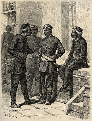
The Gurkhas or Gorkhas, with the endonym Gorkhali, are soldiers native to the Indian subcontinent, chiefly residing within Nepal and some parts of North India.

The Gorkha Kingdom, also known as the Gorkha Confederation or the Gorkha Empire, was a member of the Chaubisi rajya, a confederation of 24 states, located at the intersection of Himalayas and the Indian subcontinent. In 1743, the kingdom began a campaign of military expansion, annexing several neighbors and becoming present-day Nepal.
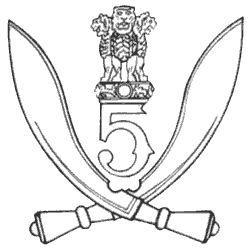
5th Gorkha Rifles, also abbreviated as 5 GR(FF) is an infantry regiment of the Indian Army comprising Gurkha soldiers of Nepalese origin. It was formed in 1858 as part of the British Indian Army. The regiment's battalions served in the First World War (Mesopotamia) and Second World War.

Bushahr, also spelt as 'Bashahr' and 'Bussahir' or 'Bushair' was a Rajput princely state in India during the British Raj. It was located in the hilly western Himalaya promontory bordering Tibet.

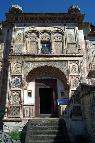
Jubbal is a tehsil, town and a nagar panchayat in Shimla district in the Indian state of Himachal Pradesh which shares its boundary with the state of Uttrakhand towards south-east. Jubbal is recognised as a major apple producing area in Shimla district along with Kotgarh, Kumarsain, Kotkhai and Chopal. It is famous for its Hindu temples, picturesque mountains and its royal palace situated in the town.

Dhami was a Princely State situated 26 kilometres (16 mi) west of Shimla, India. Its capital was Halog and the state formed a part of the region known as the Punjab Hill States Agency during the British Raj period. In 1941 it had an area of 73 square kilometres (28 sq mi) and a population of 5,114 people. In 1948 Dhami was made a part of Himachal Pradesh.
Sirmur was an independent kingdom in India, founded in 1616, located in the region that is now the Sirmaur district of Himachal Pradesh. The state was also known as Nahan, after its main city, Nahan. The state ranked predominant amongst the Punjab hill States. It had an area of 4,039 km2 and a revenue of 300,000 rupees in 1891.
Rana is a given name and surname of multiple origins.

Mehlog or Mah(i)log was a princely state of India before and during the colonial British Raj. In 1940 it had a population of 8,631 and an area of 49 square miles (130 km2). The capital city was Patta.
Darkoti State was one of the Princely states of India during the period of the British Raj. Its last ruler signed the accession to the Dominion of India on 15 April 1948. Currently, it is part of the Indian state of Himachal Pradesh.
The Kingdom of Rajgarh also known as Rajgarh State was a princely state in present-day India, named after its capital Rajgarh, Madhya Pradesh. It was part of the colonial Bhopal Agency of the Central India Agency during the British Raj. It lay in the region of Malwa known as Umathwara after the ruling Umath clan of Rajputs, a branch of the Paramara dynasty. The neighbouring Narsinghgarh State was ruled by a cadet branch of this family, after being partitioned in 1681.
Baghat was a princely state of the British Raj, located in modern-day Himachal Pradesh. It constituted one of the Simla Hill States. It consisted of three separate parts which were almost entirely surrounded by the larger Patiala territory. The largest part comprised approximately 22 square miles (57 km2), extending eastward from Solan. It incorporated Takroli, Bhocháli and part of the Básál parganas. The two smaller parts comprised about 10 square miles (26 km2) and 1 square mile (2.6 km2) respectively, and formed the remainder of the Básál pargana.

Suket State was one of the Princely states of India during the period of the British Raj. The capital of the state was Pangna. Its last ruler signed the accession to the Indian Union on 15 April 1948. Formerly it belonged to the States of the Punjab Hills and currently, it is part of the Indian state of Himachal Pradesh. The present-day Mandi district was formed with the merger of the two princely states of Mandi and Suket.

Kumarsain, also known as Kumharsain, is a town in Shimla District in the Indian state of Himachal Pradesh. Formerly under the British Raj, it was the capital of princely state of Kumharsain, which was one of the several states of the Punjab States Agency. It is about 80 km from Shimla and famous for apple and cherry orchards.
Kuthar, formerly Krishangarh, is located in the Solan district of Himachal Pradesh. Krishangarh (Kuthar) is situated on the MDR-75 i.e. Shalaghat-Arki-Kunihar-Kuthar-Patta-Brotiwala adjoining Sabathu, Kasauli area. Krishangarh is an administrative division of Solan district having sub-tehsil status.
Mangal is a former princely state in north India ruled by Chandravanshi Sen Rajputs.Mangal state like Mandi State was an off shoot of Suket State. Rana Surender Singh is its present head.

The Nepal–Sikh war was a small conflict in 1809 between the forces of the Western Province of Kingdom of Nepal under General Amar Singh Thapa and the Sikh Empire under Maharaja Ranjit Singh.