Madhya Bharat

Last updated

Madhya Bharat
State of India
1948–1956
Madhya Bharat in India (1951).svg
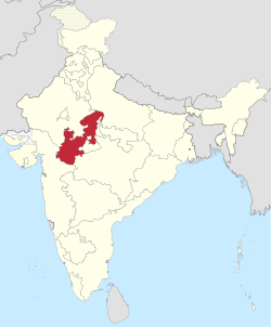
Location of Madhya Bharat in India, 1951
Area 
 1881
194,000 km2 (75,000 sq mi)
Population 
 1881
9261907
History
History 
 Abolition of the Central India Agency
1948
 Creation of Madhya Pradesh State
1956
Preceded by
Succeeded by
British Raj Red Ensign.svg Central India Agency
British Raj Red Ensign.svg Gwalior Residency
Madhya Pradesh ..Madhya Pradesh Flag(INDIA).png

Madhya Bharat, also known as Malwa Union , [1] was an Indian state in west-central India, created on 28 May 1948 [2] from twenty-five princely states which until 1947 had been part of the Central India Agency, [3] with Jiwajirao Scindia as its Rajpramukh.

Contents

The union had an area of 46,478 square miles (120,380 km2). [4] Gwalior was the winter capital and Indore was the summer capital. It was bordered by the states of Bombay (presently Gujarat and Maharashtra) to the southwest, Rajasthan to the northwest, Uttar Pradesh to the north, and Vindhya Pradesh to the east, and Bhopal State and Madhya Pradesh to the southeast. The population was mostly Hindu and Hindi-speaking.

On 1 November 1956, Madhya Bharat, together with the states of Vindhya Pradesh and Bhopal State, was merged into Madhya Pradesh.

Districts

Madhya Bharat comprised sixteen districts [4] and these districts were initially divided into three Commissioners' Divisions, which were later reduced to two. The districts were:

  1. Bhind District
  2. Gird District
  3. Morena District
  4. Guna District
  5. Shivpuri District
  6. Rajgarh District
  7. Bhilsa District
  8. Shajapur District
  9. Ujjain District
  10. Indore District
  11. Dewas District
  12. Ratlam District
  13. Dhar District
  14. Jhabua District
  15. Nimar District
  16. Mandsaur District

Politics

The nominal head of Madhya Bharat state was Rajpramukh. It had also the post of an Uparajpramukh. The state had a Vidhan Sabha of 99 members, who were elected from 79 constituencies (59 single member and 20 double member). [5] There were 9 Lok Sabha constituencies in the state (7 single member and 2 double member). [6]

Jivaji Rao Scindia was Rajpramukh of the state from 28 May 1948 to 31 October 1956 and Liladhar Joshi was the first Chief Minister. He was succeeded by Gopi Krishna Vijayvargiya in May 1949. On 18 October 1950, Takhatmal Jalori became the third Chief Minister of Madhya Bharat.

In the 1952 Madhya Bharat Legislative Assembly election, the Indian National Congress won 75 seats and the Hindu Mahasabha won 11 seats. [5] Mishrilal Gangwal of Indian National Congress became the Chief Minister on 3 March 1952. After his resignation, Takhatmal Jain (Jalori) again became the Chief Minister on 16 April 1955. [7] He was the Chief Minister of the state till 31 October 1956.

Geography

Madhya Bharat state was situated in the Madhya Bharat plateau (presently lying under most of northwestern Madhya Pradesh state and Central Rajasthan). This plateau is bounded by the Indo-Gangetic plain to the north, the Bundelkhand upland to the east, the Malwa Plateau to the south, and the East Rajasthan Uplands on the west.

Related Research Articles

<span class="mw-page-title-main">Madhya Pradesh</span> State in central India

Madhya Pradesh is a state in central India. Its capital is Bhopal, and the largest city is Indore, with Gwalior, Jabalpur, Ujjain, Dewas, Sagar, Satna, and Rewa being the other major cities. Madhya Pradesh is the second largest Indian state by area and the fifth largest state by population with over 72 million residents. It borders the states of Uttar Pradesh to the northeast, Chhattisgarh to the east, Maharashtra to the south, Gujarat to the west, and Rajasthan to the northwest.

<span class="mw-page-title-main">Vindhya Pradesh</span> Former State of India

Vindhya Pradesh was a former state of India. It occupied an area of 61,131.5 km2. It was created in 1948 as Union of Baghelkhand and Bundelkhand States, shortly after Indian independence, from the territories of the princely states in the eastern portion of the former Central India Agency. It was named as Vindhya Pradesh on 25 January 1950 after the Vindhya Range, which runs through the centre of the province. The capital of the state was the former princely state of Rewa. It lays between Uttar Pradesh to the north and Madhya Pradesh to the south, and the enclave of Datia, which lay a short distance to the west, was surrounded by the state of Madhya Bharat.

<span class="mw-page-title-main">House of Scindia</span> Maratha dynasty that ruled the Gwalior State in India

House of Scindia was a Hindu Maratha Royal House that ruled the erstwhile Gwalior State in central India. It had the patil-ship of Kumberkerrab in the district of Wai and was founded by Ranoji Scindia, who started as a personal servant of the Peshwa Bajirao I. Ranoji and his descendants, along with their rivals the Holkars, played a leading role during the Maratha ascendancy in northern India in the 18th-century. The Gwalior State became a princely state under the British Raj during the 19th and the 20th-centuries. After India's independence in 1947 and the abolition of princely states, several members of the Scindia family went on to enter Indian politics.

<span class="mw-page-title-main">Ujjain</span> City in Madhya Pradesh, India

Ujjain or Ujjayinī is a city in Ujjain district of the Indian state of Madhya Pradesh. It is the fifth-largest city in Madhya Pradesh by population and is the administrative centre of Ujjain district and Ujjain division. It is one of the Hindu pilgrimage centres of Sapta Puri famous for the Kumbh Mela held there every 12 years. The famous temple of Mahakaleshwar Jyotirlinga is located in the center of the city. The city has been one of the most prominent trade and political centres of the Indian Subcontinent from the time of the ancient Mahājanapadas until the British colonisation of India.

<span class="mw-page-title-main">Central India Agency</span> Agency of princely states in India

The Central India Agency was created in 1854, by amalgamating the Western Malwa Agency with other smaller political offices which formerly reported to the Governor-General of India. The agency was overseen by a political agent who maintained relations of the Government of India with the princely states and influence over them on behalf of the Governor-General. The headquarters of the agent were at Indore.

<span class="mw-page-title-main">Jiwajirao Scindia</span> Last ruling Maharaja of Gwalior from 1925–1948

Maharaja Jivajirao Scindia KStJ was an Indian prince and government official.

<span class="mw-page-title-main">Bhind district</span> District of Madhya Pradesh in India

Bhind district is a district in the Chambal division of the Indian state of Madhya Pradesh. The town of Bhind is the district headquarters. Bhind District is situated in Chambal region in the northwest of the state. It is bounded by Agra, Etawah, Jalaun and Jhansi districts of Uttar Pradesh state to the north and the east, and the Madhya Pradesh districts of Datia to the south, Gwalior to the southwest, and Morena to the west. The geography of the district is characterised by uneven ravines, plain fertile fields and scanty forests. The total area of the district is 4,459 km2 (1,722 sq mi).

<span class="mw-page-title-main">Guna district</span> District in Madhya Pradesh, India

Guna district is one of the 52 districts of Madhya Pradesh in central India. Its administrative headquarters is Guna. The district has a population of 1,241,519. It has an area of 6390 km², and is bounded on the northeast by Shivpuri District, on the east by Ashoknagar District, on the southeast by Vidisha District, on the southwest by Rajgarh District, on the west and northwest by Jhalawar and Baran districts of Rajasthan state. The Sindh River flows northward along the eastern edge of the district, forming part of the boundary with Ashoknagar District, and the Parvati River flows northwestward through the southern portion of the district, forming part of the boundary with Baran District before flowing into Rajasthan.

<span class="mw-page-title-main">Hatpipliya</span> Town in Madhya Pradesh, India

Hatpipalya is a town and a Nagar parishad in the Hatpipliya tehsil within Dewas district of the state of Madhya Pradesh, India. It lies 149 kilometres (93 mi) west of the state capital of Bhopal. Hatpipalya had a census-estimated 2011 population of 17,419, which makes it a Tier-4 city. The city is spread over an area of 2.21 square kilometres (0.85 sq mi).

Govind Narayan Singh, was an Indian politician. He was Chief Minister of Madhya Pradesh from July 30, 1967 to March 12, 1969. He was also Governor of Bihar state from February 26, 1988 to January 24, 1989.

<span class="mw-page-title-main">History of Madhya Pradesh</span> History of the Indian state

The history of Madhya Pradesh can be divided into three periods - the ancient period, the medieval period and modern period.

<span class="mw-page-title-main">Ater Assembly constituency</span> Constituency of the Madhya Pradesh legislative assembly in India

Ater Assembly constituency is one of the 230 Vidhan Sabha constituencies of Madhya Pradesh state in central India. This constituency came into existence in 1951, as one of the 79 Vidhan Sabha constituencies of the erstwhile Madhya Bharat state.

<span class="mw-page-title-main">Bhind Assembly constituency</span> Constituency of the Madhya Pradesh legislative assembly in India

Bhind Assembly constituency is one of the 230 Vidhan Sabha constituencies of Madhya Pradesh state in central India. This constituency came into existence in 1951, as one of the 79 Vidhan Sabha constituencies of the erstwhile Madhya Bharat state.

<span class="mw-page-title-main">Lahar Assembly constituency</span> Constituency of the Madhya Pradesh legislative assembly in India

Lahar Assembly constituency is one of the 230 Vidhan Sabha constituencies of Madhya Pradesh state in central India. This constituency came into existence in 1951, as one of the 79 Vidhan Sabha constituencies of the erstwhile Madhya Bharat state.

<span class="mw-page-title-main">Mehgaon Assembly constituency</span> Assembly constituency in Madhya Pradesh

Mehgaon Assembly constituency is one of the 230 Vidhan Sabha constituencies of Madhya Pradesh state in central India. This constituency came into existence in 1951, as Gohad Mehgaon, one of the 230 Vidhan Sabha constituencies of the erstwhile Madhya Bharat Madhya Pradesh state.

<span class="mw-page-title-main">Gohad Assembly constituency</span> Assembly constituency in Madhya Pradesh

Gohad is one of the 230 Vidhan Sabha constituencies of Madhya Pradesh state in central India. This constituency is reserved for the candidates belonging to the Scheduled castes. It came into existence in 1951, as Gohad Mehgaon, one of the 79 Vidhan Sabha constituencies of the erstwhile Madhya Bharat state.

<span class="mw-page-title-main">Sewda Assembly constituency</span> Assembly constituency in Madhya Pradesh

Sewda Assembly constituency is one of the 230 Vidhan Sabha constituencies of Madhya Pradesh state in central India. This constituency came into existence in 1951, as one of the 48 Vidhan Sabha constituencies of the erstwhile Vindhya Pradesh state. It was reserved for the candidates belonging to the Scheduled castes till 2008.

<span class="mw-page-title-main">Datia Assembly constituency</span> Assembly constituency in Madhya Pradesh

Datia Assembly constituency is one of the 230 Vidhan Sabha constituencies of Madhya Pradesh state in central India. This constituency came into existence in 1951, as one of the 48 Vidhan Sabha constituencies of the erstwhile Vindhya Pradesh state.

<span class="mw-page-title-main">1952 Madhya Pradesh Legislative Assembly election</span>

Elections to the Madhya Pradesh Legislative Assembly were held on 26 March 1952. 1,122 candidates contested for the 184 constituencies in the Assembly. There were 48 two-member constituencies and 136 single-member constituencies, for a total of 232 seats. The Indian National Congress won a majority of seats and Ravishankar Shukla became the Chief Minister.

<span class="mw-page-title-main">Political families of Madhya Pradesh</span>

The Political families of Madhya Pradesh are a group of older families that exert considerable influence throughout the region.

References

  1. India States
  2. "Bhind-History". Bhind district website. Archived from the original on 19 June 2009.
  3. Chisholm, Hugh, ed. (1911). "Malwa"  . Encyclopædia Britannica . Vol. 17 (11th ed.). Cambridge University Press. p. 518.
  4. 1 2 Bhattacharyya, P. K. (1977). Historical Geography of Madhya Pradesh from Early Records. Motilal Banarsidass. pp. 53–4. ISBN   9788120833944.
  5. 1 2 "Statistical Report on General Election, 1951 to the Legislative Assembly of Madhya Bharat" (PDF). Election Commission of India website.
  6. "Statistical Report on General Elections, 1951 to the First Lok Sabha" (PDF). Election Commission of India website. Archived from the original (PDF) on 9 April 2009.
  7. "This Day That Age - April 18, 1955: Madhya Bharat CM". The Hindu . 18 April 2005. Archived from the original on 20 April 2005. Retrieved 16 August 2009.

26°13′N78°10′E / 26.22°N 78.17°E / 26.22; 78.17