Related Research Articles

Andhra Pradesh is a state in the southern coastal region of India. It is the seventh-largest state with area of 162,970 km2 (62,920 sq mi) and tenth-most-populous state, with 49,577,103 inhabitants. It is bordered by Telangana to the north-west, Chhattisgarh to the north, Odisha to the north-east, Tamil Nadu to the south, Karnataka to the west and the Bay of Bengal to the east. It has the second longest coastline in India of about 974 km (605 mi). After existence as Andhra State and United Andhra Pradesh, the state took its present form on 2 June 2014, when the new state Telangana was formed. Amaravati serves as the capital of the state with the largest city being Visakhapatnam. The state comprises 26 districts within three regions Uttarandhra, Coastal Andhra and Rayalaseema. It is also a major producer of rice. Telugu, used by majority of people and Urdu are official languages.

India is situated north of the equator between 8°4' north to 37°6' north latitude and 68°7' east to 97°25' east longitude. It is the seventh-largest country in the world, with a total area of 3,287,263 square kilometres (1,269,219 sq mi). India measures 3,214 km (1,997 mi) from north to south and 2,933 km (1,822 mi) from east to west. It has a land frontier of 15,200 km (9,445 mi) and a coastline of 7,516.6 km (4,671 mi).

Rajasthan is a state in northern India. It covers 342,239 square kilometres (132,139 sq mi) or 10.4 per cent of India's total geographical area. It is the largest Indian state by area and the seventh largest by population. It is on India's northwestern side, where it comprises most of the wide and inhospitable Thar Desert and shares a border with the Pakistani provinces of Punjab to the northwest and Sindh to the west, along the Sutlej-Indus River valley. It is bordered by five other Indian states: Punjab to the north; Haryana and Uttar Pradesh to the northeast; Madhya Pradesh to the southeast; and Gujarat to the southwest. Its geographical location is 23.3 to 30.12 North latitude and 69.30 to 78.17 East longitude, with the Tropic of Cancer passing through its southernmost tip.

South India, also known as Peninsular India, consists of the peninsular southern part of India. It encompasses the Indian states of Andhra Pradesh, Karnataka, Kerala, Tamil Nadu, and Telangana, as well as the union territories of the Andaman and Nicobar Islands, Lakshadweep and Puducherry, comprising 19.31% of India's area and 20% of India's population. Covering the southern part of the peninsular Deccan Plateau, South India is bounded by the Bay of Bengal in the east, the Arabian Sea in the west and the Indian Ocean in the south. The geography of the region is diverse with two mountain ranges – the Western and Eastern Ghats – bordering the plateau heartland. The Godavari, Krishna, Kaveri, Tungabhadra, Periyar, Bharathappuzha, Pamba, Thamirabarani, Palar, and Vaigai rivers are important perennial rivers.
Highlands or uplands are areas of high elevation such as a mountainous region, elevated mountainous plateau or high hills. Generally, upland refers to a range of hills, typically from 300 m (980 ft) up to 500–600 m (1,600–2,000 ft), while highland is usually reserved for ranges of low mountains. However, the two terms are sometimes interchangeable.

The Vindhya Range is a complex, discontinuous chain of mountain ridges, hill ranges, highlands and plateau escarpments in west-central India.

Malwa is a historical region of west-central India occupying a plateau of volcanic origin. Geologically, the Malwa Plateau generally refers to the volcanic upland north of the Vindhya Range. Politically and administratively, it is also synonymous with the former state of Madhya Bharat which was later merged with Madhya Pradesh. At present the historical Malwa region includes districts of western Madhya Pradesh and parts of south-eastern Rajasthan. Sometimes the definition of Malwa is extended to include the Nimar region south of the Vindhyas.

Penna is a river of southern India. This is a unique river in world where after originating from Nandi hills, it flows as two different streams, one in North and South directions. The Penna rises in the Nandi Hills in Chikkaballapur District of Karnataka state, and runs north and east through the states of Karnataka and Andhra Pradesh to empty into bay of bengal in Andhra Pradesh. It is 597 kilometres (371 mi) long, with a drainage basin covering 55,213 km2: 6,937 km2 in Karnataka and 48,276 km2 in Andhra Pradesh. Along with this main stream there is another stream south towards Tamilnadu with the name Then Pennai or south Pennar which further moves towards the east to empty into the Bay of Bengal.The Penna river basin lies in the rain shadow region of Eastern Ghats and receives 500 mm average rainfall annually.

North India is a loosely defined region consisting of the northern part of India. The dominant geographical features of North India are the Indo-Gangetic Plain and the Himalayas, which demarcate the region from the Tibetan Plateau and Central Asia.

Marwar is a region of western Rajasthan state in North Western India. It lies partly in the Thar Desert. The word 'maru' is Sanskrit for desert. In Rajasthani languages, "wad" means a particular area. English translation of the word 'marwar' is 'the region of desert.'

The Ganges Basin is a part of the Ganges-Brahmaputra-Meghna (GBM) basin draining 1,999,000 square kilometres in Tibet, Nepal, India and Bangladesh. To the north, the Himalaya or lower parallel ranges beyond form the Ganges-Brahmaputra divide. On the west the Ganges Basin borders the Indus basin and then the Aravalli ridge. Southern limits are the Vindhyas and Chota Nagpur Plateau. On the east the Ganges merges with the Brahmaputra through a complex system of common distributaries into the Bay of Bengal. Its catchment lies in the states of Uttar Pradesh (294,364 km2), Madhya Pradesh (198,962 km2), Bihar (143,961 km2), Rajasthan (112,490 km2), West Bengal (71,485 km2), Haryana (34,341 km2), Himachal Pradesh (4,317 km2), Delhi, Arunachal Pradesh (1,484 km2), the whole of Bangladesh, Nepal and Bhutan. Several tributaries rise inside Tibet before flowing south through Nepal. The basin has a population of more than 500 million, making it the most populated river basin in the world.

The Rathore or Rathor is an Indian Rajput dynasty belonging to the clan that has historically ruled over parts of Rajasthan, Gujarat and Madhya Pradesh.

Adoni is a city in the Kurnool district in the Indian state of Andhra Pradesh. It is a municipality and the headquarters of Adoni mandal, administered under the Adoni Revenue Division. In the 2011 census of India, Adoni had a population of 166,344, making it the 16th most populous town in the state with an urban agglomeration population of 184,625.
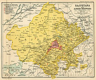
Rājputana, meaning "Land of the Rajputs", was a region in the Indian subcontinent that included mainly the present-day Indian state of Rajasthan,punjab, as well as parts of Madhya Pradesh and Gujarat, and some adjoining areas of Sindh in modern-day southern Pakistan.
Seshachalam Hills are hilly ranges part of the Eastern Ghats in southern Andhra Pradesh state, in southeastern India. The Seshachalam hill ranges are predominantly present in Tirupati district of the Rayalaseema region in Andhra Pradesh, India.

The Geography of South India comprises the diverse topological and climatic patterns of South India. South India is a peninsula in the shape of a vast inverted triangle, bounded on the west by the Arabian Sea, on the east by the Bay of Bengal and on the north by the Vindhya and Satpura ranges.

The following outline is provided as an overview of, and topical guide to, India:

Odisha is one of the 28 states in the Republic of India. Odisha is located in the eastern part of the Indian peninsula and the Bay of Bengal lies to its East while Chhattisgarh shares its border in the west and north-west. The state also shares geographic boundaries with West Bengal in the north-east, Jharkhand in the north and Andhra Pradesh in the south. The state is spread over an area of 1,55,707 km2 and extends for 700 km from north to south and 500 kilometres from east to west. Its coastline is 450 km long. The state is divided into 30 districts which are further subdivided into 314 blocks.
Rajasthani people or Rajasthanis are a group of Indo-Aryan peoples native to Rajasthan, a state in Northern India. Their language, Rajasthani, is a part of the western group of Indo-Aryan languages.
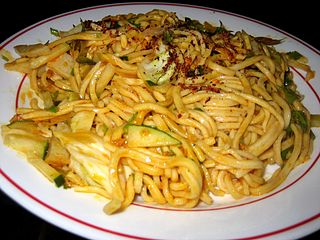
Khauk swè thoke is an a thoke salad dish in Burmese cuisine. A wheat noodle salad, it is made with dried shrimp, shredded cabbage, carrots, fish sauce, lime and dressed with fried peanut oil.
References
- 1 2 Sharma, Pradeep (2008). Insect Hormones. Discovery Publishing House. ISBN 81-8356-290-6.
- ↑ Murty, M. L. K. (2003). Comprehensive History and Culture of Andhra Pradesh: Pre- and protohistoric Andhra Pradesh up to 500 BC. Vol. 1. Orient Blackswan. ISBN 81-250-2475-1.
- ↑ Mohammad, Ali (1989). "Environmental Framework of Indian Agriculture – A Regional Dimension". Food production and food problem in India. Concept Publishing Company. ISBN 81-7022-269-9.
| | This article related to a location in Rajasthan is a stub. You can help Wikipedia by expanding it. |