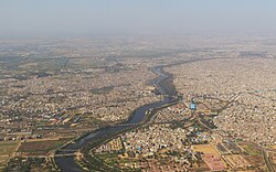
Najafgarh Drain River Sahibi (Northernmost end) | |
---|---|
Location | |
Country | India |
City | Delhi |
Physical characteristics | |
Mouth | Yamuna River |
• location | Delhi, India |
Basin features | |
River system | Yamuna River |
Landmarks | Najafgarh lake, Najafgarh Drain Bird Sanctuary |
Pollution status | Highly polluted due to sewage inflow |
The Najafgarh drain or Najafgarh nalah (nalah in Hindi means rivulet or storm water drain), which also acts as Najafgarh drain bird sanctuary, is another name for the northernmost end of River Sahibi, which continues its flow through Delhi, where it is channelized, and then flows into the Yamuna. Within Delhi, due to its channelization for flood control purposes, it is now erroneously called "Najafgarh drain" or "Najafgarh nullah." It gets this name from the once famous and huge Najafgarh Jheel (lake) near the town of Najafgarh in southwest Delhi and within urbanized Delhi. It is the Indian capital's most polluted water body due to direct inflow of untreated sewage from surrounding populated areas. A January 2005 report by the Central Pollution Control Board classifies this drain, with 13 other highly polluted wetlands, under category ‘'D'’ for assessing the water quality of wetlands in wildlife habitats. [1] [2] [3] [4] [5]
This drain was widened as a flood control drain linking the Najafgarh lake to the river Yamuna, thus completely draining the once huge and ecologically rich Najafgarh Lake, famous for its wetland ecosystem, waterbirds and Wildlife.
Within the National Capital Territory of Delhi (NCT), this channelized waterway—misclassified, misnamed as a mere drain (Najafgarh drain or nullah)--is, in fact, the continuation of the Sahibi River and an elongation of the Najafgarh jheel Lake. During the 1960s and before, the rain-fed Sahibi River, which originates in the Jaipur District of Rajasthan, passing through Alwar District in Rajasthan and Gurgaon District in Haryana, entered Delhi near Dhansa and spilled its overflow in the Najafgarh Lake basin. This overflow created a seasonal lake; an area of more than 300 square kilometres (120 sq mi) was submerged in some seasons. This water then continued to flow on the other side, forming a tributary of the River Yamuna. In the following decades, this Sahibi River flow reaching the Dhansa regulators was channelized by digging out a wide drain and connecting it directly to the River Yamuna. This channelization also completely drained off the seasonal Najafgarh Jheel that had formed there previously. The channelized drain from Dhansa regulators to Keshopur Bus Depot on Outer Ring Road is wide with thick and high embankments. A vast amount of water is retained in this widened drain by closing the Kakrola regulators under Najafgarh Road to recharge the local ground watertable; hence it acts like an elongated lake as well. [6]
Wetland ecosystem and wildlife habitat important to migratory waterbirds and local wildlife
The drain has been much widened over the years to drain all the water which in earlier decades used to collect in the Nagafgarh Jheel basin; this was supposedly done to remove the threat of flooding in Delhi [7] [8] and now the drain itself acts as an elongated water body or lake with trees planted on both its embankments with an inspection road running on one embankment. During the winter months it attracts vast numbers of migratory birds and also supports local wildlife year-round. Due to the rich wildlife observed in and around the less polluted stretch of the drain outside of congested populated areas, it has been proposed as a bird sanctuary for Delhi. [9] [10] [11]
The wetland ecosystem and wildlife habitat on several kilometers of less polluted Najafgarh drain in rural Delhi before entering the main city including the former Najafgarh lake or Najafgarh jheel area is very important habitat to migratory waterbirds as well as local wildlife and has been earmarked to be declared a bird sanctuary for Delhi. The area came to be recognized as an important wildlife habitat after a local naturalist studying the area during 1986–88 called attention to it recommending it to be conserved as a bird sanctuary after which the Delhi wildlife department posted 16 guards in the area to control illegal bird hunters including diplomats from various international embassies located in Delhi, India's capital. Delhi Administration officials were tasked with declaring about 25-kilometre (16 mi) stretch of the drain in rural Delhi, including where it passes through the core area of the now drained Najafgarh Lake, "protected" under the "Wildlife Act" after Lt.-Governor of Delhi Mr. H.L. Kapur was invited to the area for touring the site where he also heard accounts of local villagers about the rampant illegal hunting of waterbirds that went on here every year. The existing staff of the Flood Control and Irrigation Department numbering about 40 were also given the additional responsibility of protecting the wildlife on and around the drain. [12] [13] [14]
The Najafgarh drain has been much widened over the past decades and now has thick mud embankments on both its sides to channel the waters and protect Delhi from floods, these embankments have been planted with thick forest cover which serve as a much needed habitat for remnant local wildlife occurring in nearby and surrounding farmlands including common foxes, jackals, hares, wild cats, nilgai, porcupines and various reptiles and snakes including the dreaded cobras. Many local birds including waterbirds roost and nest in these trees.
Sections of the forested embankments of Najafgarh drain are currently classified as and are featured in Protected Forests and Recorded Forests (Notified Forest Areas in Delhi) as "M. P. Green area Najafgarh Drain (Tagore garden)", "Afforestation M.P.Green Area Najafgarh Drain (DDA)" and "Chhawla or Najafgarh drain city forest (29.64 Acre)". [15] [16] [17] [18] [19]
There is a well kept drivable inspection road maintained by Irrigation and Flood Control Department of Delhi on one of the drains embankment throughout its entire length of several kilometers running through rural Delhi from Dhansa regulators at the southwest border of Delhi with the state of Haryana to where the drain crosses under the outer ring road at Keshopur bus depot near the Najafgarh road between the housing colonies of Vikaspuri and Tilak Nagar in New Delhi.
Bird-watchers and nature-lovers can view the wildlife and waterbirds occurring on the drain from vehicles by driving on this road and stopping intermittently and going down to the waters edge. As the width of the drain is limited the flocks of waterfowl and other waterbirds in the drain can be easily observed from the drain's edges and this same fact makes the birds much more vulnerable to hunting as they remain in easy reach of the poacher's shotguns and the nets and traps set for them by local villagers and professional trappers.
The continuous widening of the Najafgarh drain since the 1960s led to the complete draining of the once vast and rich Najafgarh lake, jheel or marsh which directly affected the ground water table in the entire surrounding region as all the rain water after yearly monsoons that used to collect in the vast lake basin in previous years now ran off swiftly through the widened drain into river Yamuna in which it outfalls, this has been affecting the entire climate of the region as well making the region more arid and creating water shortages for the purpose of irrigation or human consumption for the people of Delhi and surrounding regions.
Currently the drain is so wide and deep that it acts as an elongated lake in its own right and can hold and store a lot of rain water which can be regulated through regulators built into it at intervals. Maintaining of proper water-level in the drain and storage of rainwater in it during the summer months leads to recharging of ground water table [20] which the surrounding farmers find much helpful as they access the high water table though tube wells dug on their farmlands though which they pump water to irrigate their crops. Farmers owning farmlands bordering the drain in rural Delhi directly use pipes and hoses to pump water from the drain for irrigation. [21]
The relatively cleaner portion of the drain in rural southwest Delhi before it enters densely populated and badly polluted area at Vikaspuri also attracts some small scale local village fishermen, occasionally one can be seen casting his line or net in the waters or floating on a black inflated truck tire tube spreading his fishing net across the breadth of the drain. A fishing license is needed to catch fish legally in Delhi waters.
The water hyacinth, an introduced invasive species of fast growing floating plants completely clogs the open water surface of the drain in many areas annually and lot of funds and labour is employed by the flood control department to clear it somewhat to keep the water flow uninterrupted. The removing of the water hyacinth by laborers also opens up the water surface for birds and migratory waterfowl that take refuge here every winter.
There is a development scheme in the works where Najafgarh drain will be covered by the Flood Department from Vijay Nagar, Delhi to Hakikat Nagar and on the covered area shops will be built. [22]
Najafgarh lake, Najafgarh marsh or Najafgarh jheel (Jheel in Hindi means a lake) used to be a vast lake in the south west of Delhi in India near the town of Najafgarh from which it takes its name, it was connected to the river Yamuna by a natural shallow nullah or drain called the Najafgarh nullah. However, after the 1960s the Flood Control Department of Delhi kept widening the Najafgarh drain in the pretext of saving Delhi from floods and eventually quickly drained the once huge and ecologically rich Najafgarh lake completely. Rainwater accumulating in the Najafgarh lake or jheel basin had been recorded to have occupied more than 300 square kilometers in many years before its unfortunate draining.
However, with recent advances in ecological understanding it has become clear that draining of this vast lake affected the entire climate of this important region that is India's capital territory and its neighborhood. The draining of the lake completely also caused the watertable in the entire area to go down and the area becoming arid. There have been some plans since to at least resurrect a much smaller lake in the area. Most of the Najafgarh jheel basin lands have increased many folds in their value owing to them coming within Delhi, India's capital territory and are under ownership of farmers who may want to make a fast buck selling them to developers who want to convert the former lake basin into housing complexes as has already been happening with major housing colonies coming up in the region. If Najafgarh drain, which was built to drain the original Najafgarh lake or jheel, ever breaches its wide embankments it will flood these developed lands owing to them spread all over the former low lying jheel or lake basin.
Before the unfortunate complete draining of this lake in the 1960s by widening of the Najafgarh drain by the Flood control and irrigation department of Delhi the lake in many years filled up a depression more than 300 square kilometres (120 sq mi) in rural Delhi, It had an extremely rich wetland ecosystem forming a refuge for vast quantities of waterbirds and local wildlife. The lake was one of the last habitats of the famed and endangered Siberian Crane which has all but vanished from the Indian subcontinent now. Till before independence many British colonial Officers and dignitaries came in large parties for waterfowl hunting every season. [23] [24] [25]
The Yamuna is the second-largest tributary river of the Ganges by discharge and the longest tributary in India. Originating from the Yamunotri Glacier at a height of about 4,500 m (14,800 ft) on the southwestern slopes of Bandarpunch peaks of the Lower Himalaya in Uttarakhand, it travels 1,376 kilometres (855 mi) and has a drainage system of 366,223 square kilometres (141,399 sq mi), 40.2% of the entire Ganges Basin. It merges with the Ganges at Triveni Sangam, Prayagraj, which is a site of the Kumbh Mela, a Hindu festival held every 12 years.
Gurgaon, officially named Gurugram, is a satellite city of Delhi and administrative headquarters of Gurgaon district, located in the northern Indian state of Haryana. It is situated near the Delhi–Haryana border, about 30 kilometres (19 mi) southwest of the national capital New Delhi and 268 km (167 mi) south of Chandigarh, the state capital. It is one of the major satellite cities of Delhi and is part of the National Capital Region of India. As of 2011, Gurgaon had a population of 876,969.
The Aravalli Range is a mountain range in Northern-Western India, running approximately 670 km (420 mi) in a south-west direction, starting near Delhi, passing through southern Haryana, Rajasthan, and ending in Ahmedabad Gujarat. The highest peak is Guru Shikhar on Mount Abu at 1,722 m (5,650 ft). The Aravalli Range is one of the oldest geological features on Earth, having its origin in the Proterozoic era.
Najafgarh is a town in the South West Delhi district of National Capital Territory of Delhi, India. It is one of the three subdivisions of the Southwest Delhi district. Najafgarh is located on outskirts of NCT Delhi in south western part of Delhi sharing its territory limits with Gurgaon and Bahadurgarh, in Haryana.
Sultanpur National Park (formerly Sultanpur Bird Sanctuary) is located at Sultanpur village on Gurugram-Jhajjar highway, 15 km from Gurugram, Haryana and 50 km from Delhi in India. This covers approximately 142.52 hectares.
Gurgaon district, officially known as Gurugram district, is one of the 22 districts of Haryana in northern India. The city of Gurgaon is the administrative headquarters of the district. The population is 1,514,432. It is one of the southern districts of Haryana. On its north, it is bounded by the district of Jhajjar and the Union Territory of Delhi. Faridabad district lies to its east. To its south lie the districts of Palwal and Nuh. To the west lies Rewari district.
Okhla Bird Sanctuary is a bird sanctuary at the Okhla barrage over Yamuna River. It is situated in Noida, Gautam Buddh Nagar district, on Delhi-Uttar Pradesh state border and known as a haven for over 300 bird species, especially waterbirds. In 1990, an area of 3.5 square kilometres (1.4 sq mi) on the river Yamuna was designated a bird sanctuary by the Government of Uttar Pradesh under the Wildlife Protection Act, 1972. The site is located at the point where the river enters Uttar Pradesh. The most prominent feature of the sanctuary is the large lake created by damming the river, which lies between Okhla village to the west and Gautam Budh Nagar to the east. The Okhla Bird Sanctuary (OBS) is roughly 4 square kilometres in size and is situated at the entrance of NOIDA in Gautam Budh Nagar district of Uttar Pradesh. It is situated at a point where river Yamuna enters in the state of Uttar Pradesh leaving the territory of Delhi. It is one among fifteen bird sanctuaries in the state.
Najafgarh Lake, Najafgarh Marsh or Najafgarh Jheel, fed by Sahibi River, used to be a vast lake in the south west of Delhi, near the town of Najafgarh, from which it takes its name. It was connected to the river Yamuna by a natural shallow nullah or drain called the Najafgarh nullah. However, after the 1960s the Flood Control Department of Delhi kept widening the Najafgarh drain. The reason provided by the department was saving Delhi from floods. This widening led to the eventually drainage of, the once huge and ecologically rich, Najafgarh lake. Rainwater accumulating in the Najafgarh lake or jheel basin had been recorded to have occupied more than 300 square kilometres (120 sq mi) in many years before its draining.
Najafgarh drain bird sanctuary(proposed)and wetland ecosystem is composed of the wetland ecosystem and wildlife habitat on several kilometres of the Najafgarh drain or nullah which passes through rural southwest Delhi in India's capital territory. It includes the portion draining the depression or basin area that formed the once famous but now completely drained Najafgarh lake or Najafgarh jheel.
Asola-Bhati Wildlife Sanctuary covering 32.71 km2 area on the Southern Delhi Ridge of Aravalli hill range on Delhi-Haryana border lies in Southern Delhi as well as northern parts of Faridabad and Gurugram districts of Haryana state. Biodiversity significance of Ridge lies in its merger with Indo-Gangetic plains, as it is the part of the Northern Aravalli leopard wildlife corridor, an important wildlife corridor which starts from the Sariska National Park in Rajasthan, passes through Nuh, Faridabad and Gurugram districts of Haryana and ends at Delhi Ridge.
Haryana Environment Protection Council (HEPC) is an advisory committee formed in 2006 to advise the Ministry of Environment, Govt. of Haryana on environment issues. It is headquartered at Chandigarh. The committee was scheduled to be reconstituted in year 2011.
Chhawla or Najafgarh drain city forest consists of forestry plantations near the town of Chhawla on both embankments of Najafgarh drain, which is the delhi-end of Sahibi River originating from Aravalli range mountain in Rajasthan, flowing along the border of Haryana state and south west Delhi in India before converging with Yamuna. It provides refuge to local and migratory wildlife specially waterfowl and other water birds. The area is a subset of the entire Najafgarh drain in rural south west Delhi with forested plantations on both its embankments which has been proposed as the Najafgarh drain bird sanctuary.
Bhalswa Horseshoe Lake, or Bhalswa Jheel, is a lake in northwest Delhi, India. It was originally shaped like a horseshoe. However, over the years half of it was used as a landfill area. Now a low income housing colony, an extension of the nearby town of Bhalswa Jahangir Puri, Mukundpur, has been built on it, destroying the once excellent wetland ecosystem and wildlife habitat of the region which once played host to scores of local and migratory wildlife species, especially waterbirds, including waterfowl, storks and cranes. This horseshoe lake was originally formed when the nearby River Yamuna left behind one of its meandering loops here when it changed course over the years and is now channelled through more defined and fortified embankments and dykes to defend modern Delhi from floods. Bhalswa lake but it's half area under Mukundpur colony
The Sahibi river, also called the Sabi River, is an ephemeral, rain-fed river flowing through Rajasthan, Haryana and Delhi states in India. It originates in the eastern slopes of the Saiwar Protected Forest (PF) hills in Sikar District, enters Jaipur district near the foot of these hills, and after initially flowing southeast and east turns northeastwards near Shahpura and continues further till it exits Rajasthan to enter Haryana and further drains into Yamuna in Delhi, where its channeled course is also called the Najafgarh drain, which also serves as Najafgarh drain bird sanctuary. It flows for 300 km of which 157 km is in Rajasthan 100 km is in Haryana and 40 km in Delhi.
Bhindawas Wildlife Sanctuary Ramsar site is located in Jhajjar district, which is about 15 km from Jhajjar in Haryana. On 3 June 2009, it is also declared as bird sanctuary by the Indian Government.
Khaparwas Bird Sanctuary is a bird sanctuary in Jhajjar district, about 80 kilometres (50 mi) west of Delhi). The reserve covers 82.70 hectares. This is an important part of ecological corridor along the route of Sahibi River which traverses from Aravalli hills in Rajasthan to Yamuna via Masani barrage, Matanhail forest, Chhuchhakwas-Godhari, Khaparwas Wildlife Sanctuary, Bhindawas Wildlife Sanctuary, Outfall Drain Number 8 and 6, Sarbashirpur, Sultanpur National Park, Basai and The Lost Lake (Gurugram). It lies 5 km northwest of Bhindawas Bird Sanctuary and 46 km northwest of Sultantpur National Park via road.
Blue Bird Lake, Hisar is a resident and endangered migratory bird wetland habitat, lake and recreation area in the town of Hisar, in the Hisar district of Haryana State, India.
Basai wetland, located in Basai village in Gurgaon tehsil in Gurgaon district in Haryana, India, is a flora and fauna rich water body. It is recognised as one of India's Important Bird and Biodiversity Areas and is of global conservation significance as it supports populations of several endangered, vulnerable, and threatened bird species. Basai wetlandis recognised globally as an Important Bird Area (IBA) by the BirdLife International housing 20,000 birds of over 280 species including migratory birds and endangered birds, has not yet been declared a protected wetland by the Government of Haryana.
The Wazirabad barrage or Wazirabad bridge, built in 1959 is a 1,491 ft long weir across Yamuna River, in north Delhi. ITO barrage and Okhla barrage are 2 downstream barrages in Delhi and are managed by Haryana and UP respectively, whereas the Wazirabad barrage is under the management of Delhi govt.
Masani barrage, also Masani bridge, a barrage on the seasonal Sahibi River completed in 1989, is named after the Masani village in Rewari District of Haryana in India. Masani barrage also serves as a bridge on NH 919. Water storage in the barrage was made perennial in 2017 after a gap of 50 years. This barrage is important part of ecological corridor along the route of Sahibi river which traverses from Aravalli hills in Rajasthan to Yamuna via Matanhail forest, Chhuchhakwas-Godhari, Khaparwas Wildlife Sanctuary, Bhindawas Wildlife Sanctuary, Outfall Drain Number 8 and 6, Sarbashirpur, Sultanpur National Park, Basai and The Lost Lake (Gurugram).
{{cite web}}
: CS1 maint: archived copy as title (link)