
The Yamuna is the second-largest tributary river of the Ganges by discharge and the longest tributary in India. Originating from the Yamunotri Glacier at a height of about 4,500 m (14,800 ft) on the southwestern slopes of Bandarpunch peaks of the Lower Himalaya in Uttarakhand, it travels a total length of 1,376 kilometres (855 mi) and has a drainage system of 366,223 square kilometres (141,399 sq mi), 40.2% of the entire Ganges Basin. It merges with the Ganges at Triveni Sangam, Prayagraj, which is a site of the Kumbh Mela, a Hindu festival held every 12 years.

Yamunanagar, is a city and a municipal corporation in Yamunanagar district in the Indian state of Haryana. This town is known for the cluster of plywood units and paper factories. It provides timber to larger industries. The older town is called Jagadhri. The Yamunanagar-Jagadhri railway station (YJUD) services the city. Despite its name, Jagadhri Railway is situated in Yamunanagar. There is also another railway station called Jagadhri Workshop in Yamunanagar.

Kalesar National Park and adjacent Kalesar Wildlife Sanctuary (13,209 acres are protected areas in Yamunanagar district of Haryana state in India, 122 kilometres from Chandigarh. Kalesar National Park was established in 2003. Kalesar National Park and Kalesar Wildlife Sanctuary are contiguous to Simbalbara National Park in Himachal Pradesh and Rajaji National Park in Uttarakhand. Kalesar is a popular destination for leopards, panthers, elephants, red jungle fowl and bird-watching. This forested area in the Shivalik foothills is covered primarily with sal with smattering of Semul, Amaltas and Bahera trees as well. Wildlife jeep safaris are available on 3 tracks. Park is closed July to September and during the remaining months visiting hours are 6 am to 10 am and 4 pm to 7 pm during summers, and 7 am to 11 am and 3.30 pm to 6 pm during winters.
Jagadhri is a city and a municipal council in the Yamunanagar district of the Indian state of Haryana. This town lies adjacent to the city of Yamunanagar. The demarcation line between the two is difficult to discern. Jagadhri is around 90 km away from Chandigarh, the capital city of Haryana state. This town is known for the cluster of brass and copper industries. Jagadhri is known as the "Brass City" of India.
Chhachhrauli is a tehsil and Gram Panchayat town consisting of 20 wards in Yamuna Nagar district in the state of Haryana, India. It is 11 km north-east of Jagadhari. Chachhraulli is often known as "Cherapunjii of Haryana" as it receives the most rain in the whole of Haryana . It was a municipal committee until 1998. Before independence in 1947, it was the capital of the princely state of Kalsia. The origin of word Chhachhrauli is believed to be "Sat Sherawali" due to a temple located near bus terminus.
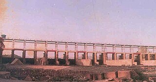
Tajewala Barrage is a now decommissioned but existing old barrage across the Yamuna River, located in Yamuna Nagar District, in the state of Haryana, India. Completed in 1873, it regulated the flow of the Yamuna for irrigation in Uttar Pradesh and Haryana through two canals originating at this place namely Western Yamuna Canal and Eastern Yamuna Canal, as well as the municipal water supply to Delhi.
Okhla is an urban neighborhood located near the Okhla barrage in the South East Delhi district of Delhi near the border between Delhi and Uttar Pradesh. Okhla has lent its name to the nearby planned township of New Okhla Industrial Development Authority or NOIDA. Okhla is also an assembly constituency.
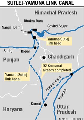
Satluj Yamuna Link Canal or SYL as it is popularly known, is an under-construction 214-kilometer (133 mi) long canal in India to connect the Sutlej and Yamuna rivers. However, the proposal met obstacles and was referred to the Supreme Court of India. It was defined as river water sharing between the states of Punjab and Haryana.

The Hathni Kund is a concrete barrage located on the Yamuna River in Yamuna Nagar district of Haryana state, India. It was constructed between October 1996 and June 1999 for the purpose of irrigation. It replaced the Tajewala Barrage 3 km (2 mi) downstream which was constructed in 1873 and is now out of service. The barrage diverts water into the Western and Eastern Yamuna Canals. The small reservoir created by the barrage also serves as a wetland for 31 species of waterbird.
Masani is a village on Sahibi River barrage in Rewari District in the Indian state of Haryana. it is location of lake, eco-tourism, farm tourism and industrial units. It is situated on Rewari-Dharuhera road section of national highway NH 919 that connects Rewari to Sohna and Palwal.

The Kaushalya Dam is an earth-fill embankment dam on the Kaushalya river, which is a tributary of Ghaggar-Hakra River, in Pinjore of Haryana state, India. It was constructed between 2008 and 2012 with the primary purpose of water supply.
The Ch. Devi Lal Rudraksh Vatika Herbal Nature Park, in short Rudraksh Vatika, is a 184 acre forested wildlife area, wetland and herbal park for the conservation of biodiversity of over 400 endangered ayurvedic medicinal herbs in Shivalik foothills of Himalayas. It is located on the western bank of Western Yamuna Canal, 1.3 km east of NH-907, in Chuharpur Kalan village of Yamunanagar district of Haryana state in India.
Western Yamuna Canal is canal in river Yamuna that was dug out and renovated in 1335 CE by Firoz Shah Tughlaq. In 1750 CE, excessive silting caused it to stop flowing. The British raj undertook a three-year renovation in 1817 by Captain GR Blane of the Bengal Engineer Group. In 1832-33 Tajewala Barrage dam at Yamuna was also built to regulate the flow of water, and later Pathrala barrage at Dadupur and Somb river dam downstream of canal were constructed in 1875-76. In 1889-95 the largest branch of the canal Sirsa branch was constructed. The modern Hathni Kund Barrage was built in 1999 to handle the problem of silting to replace the older Tajewala Barrage.
Pathrala Barrage is a barrage across the Somb river, located in Yamuna Nagar District, in the state of Haryana, India.

The Wazirabad barrage or Wazirabad bridge, built in 1959 is a 1,491 ft long weir across Yamuna River, in north Delhi. ITO barrage and Okhla barrage are 2 downstream barrages in Delhi and are managed by Haryana and UP respectively, whereas the Wazirabad barrage is under the management of Delhi govt.
The ITO barrage, also Indraprastha barrage and ITO Bridge, is a 552 meter barrage on Yamuna River, top of which also serves as the bridge on the Paharganj-Gaziabad Vikas marg. Yamuna flows for 48 km in Delhi, including 22 km from Wazirabad barrage where it enters Delhi to Okhla barrage after which it enters Haryana. Upstream barrage from ITO barrage in Delhi is Wazirabad barrage (north) and downstream is Okhla barrage (south). Yamuna has a total of 6 barrages, from north-west to south-east, Dakpathar Barrage (Uttarakhand), Hathni Kund Barrage, Wazirabad barrage, ITO barrage, Okhla barrage and Mathura barrage.
The Palla barrage is a barrage located in Palla on the Yamuna-Faridabad canal in Faridabad district of Haryana state in India. This irrigation canal runs to the west of Yaumna through Fridabad, Palwal, Mathura and Agra districts where it terminates in the farms. Palla, Faridabad is not to be confused with Palla, Delhi, a Yamuna pollution monitoring station 23 km upstream of Wazirabad barrage.

The Gokul barrage, also Mathura barrage is a barrage on Yamuna River at Gokul in Mathura district, top of which also serves as the road bridge.
The New Ohkla Barrage is a weir impounding the Yamuna River, southeast of New Delhi.