
Champawat is a town and a Nagar Palika Parishad in Champawat district in the state of Uttarakhand, India. It is the administrative headquarters of Champawat district. The town was the former capital of the Kumaon Kingdom.

Sonipat district is one of the 22 districts of Haryana state in North India. Sonipat town is the district headquarters. It is a part of National Capital Region. It is bordered by Delhi, Panipat, Rohtak, Jind, Jhajjar and Baghpat.

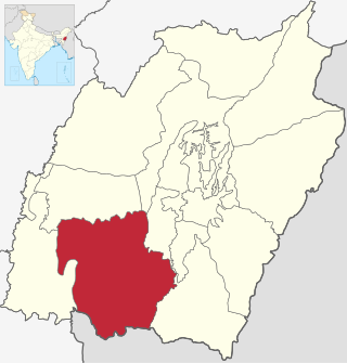
Jind district is one of the 22 districts of Haryana state in northern India. Jind town is the administrative headquarters of the district. It is part of Hisar Division and was created in 1966.

Khed is a municipal council in the Ratnagiri district of the state of Maharashtra, India. Khed town is situated on the Mumbai - Ratnagiri Highway.
Churachandpur District, is one of the 16 districts of the Indian state of Manipur populated mainly by Kuki-Zomi people. The name honours former Maharaja Churachand Singh of Manipur. The district headquarters is located in the town of Churachandpur, which is also locally known by the name Lamka.
Jamui is a district among 38 districts of Bihar state, India. The district was formed on 21 February 1991, when it was separated from Munger district. It is located at a longitude of 86° 13'E and the latitude is 24° 55'N.

Tirunelveli district is one of the 38 districts of Tamil Nadu state in India. It is the largest district in terms of area with Tirunelveli as its headquarters. The district was formed on 1 September 1790 by the British East India Company, and comprised the present Tirunelveli and Thoothukudi, Tenkasi and parts of Virudhunagar and Ramanathapuram district. As of 2011, the undivided district had a population of 3,077,233.

Vizianagaram district is one of the six districts in the Uttarandhra region of the Indian state of Andhra Pradesh with its headquarters located at Vizianagaram. The district was once the part of ancient Kalinga.Saripilli Dibbilingeswara temple, Jayathi Mallikarjuna Temple are the finest examples of ancient Eastern Ganga Dynasty built monuments in the district. The district is bounded on the east by the district of Srikakulam, north by Parvathipuram Manyam south by Visakhapatnam, Anakapalli, southeast by the Bay of Bengal, and west by Alluri Sitharama Raju district. It was formed on 1 June 1979, with some parts carved from the neighbouring districts of Srikakulam and Visakhapatnam. The district is named after the princely state of Vizianagaram. In 2011, it was the least populous district in Andhra Pradesh.

Jind is one of the largest and oldest city in Jind district in the Indian state of Haryana. It is administrative headquarter of Jind district. Rani Talab is the main destination for tourists while Pandu Pindara and Ramrai are the main religious spots, attracting devotees for the holy bath during Amavasya.

Kaithal district is one of the 22 districts of Haryana, a state in northern India. Kaithal town is the district headquarters. The district occupies an area of 2317 km2. It has a population of 1,074,304. It is part of Karnal division. Kaithal was notified as district by Haryana Govt. on 16 October 1989 and carved out of Kurukshetra and Jind districts, comprising Guhla and Kaithal sub-divisions of Kurukshetra district, Kalayat sub-tahsil and 6 villages of Jind district.

Nagapattinam district is one of the 38 districts of Tamil Nadu state in southern India. Nagapattinam district was carved out by bifurcating the erstwhile composite Thanjavur district on 19 October 1991. The town of Nagapattinam is the district headquarters.
Safidon is a city and a municipal committee in Jind district in the Indian state of Haryana.Safidon was anciently known as "Sarp Daman"

Tarakeswar is a famous sacred city and a municipality in Hooghly district in the Indian state of West Bengal. Tarakeswar is called "Baba Dham" or "The city of Shiva". It is one of the major tourist and holy place of West Bengal as well as India. Tarakeswar is a place of pilgrimage of Lord Shiva sect in West Bengal 58 kilometres (36 mi) away from State Capital Kolkata and about 1,520 kilometres away from National Capital New Delhi. Tarakeswar can be reached conveniently by train and bus from various places of West Bengal. Tarakeswar Station is well connected by Howrah Station. This city is also famous for agriculture, Tarakeswar's potato is also famous in all over India.
Ajgaon is a village in the state of Maharashtra, India. It is located in the Sawantwadi taluk of Sindhudurg district in Maharashtra.

Dinhata I is a community development block that forms an administrative division in the Dinhata subdivision of the Cooch Behar district in the Indian state of West Bengal.
Bhood is a village in Khanapur tehsil of Sangli district in Maharashtra, India. It is located near the city Vita.

Naguran is one of the biggest villages in Jind district, Haryana state, India. It is located on 29°26'15"N 76°22'21"E. The pin code of Naguran Jind is 126125. Jind, the nearest city, is located at 29.32°N 76.32°E. It has an average elevation of 227 metres. Naguran is 14–15 km from Jind.
Itkhori is a community development block that forms an administrative division in the Chatra subdivision of the Chatra district, Jharkhand state, India.

Asifabad is a census town and the district headquarters of Kumuram Bheem district in the Indian state of Telangana. It is located in Asifabad mandal of Asifabad revenue division. It is situated on the banks of Peddavagu river. It is about 309 kilometres (192 mi) north of the state capital Hyderabad,86 kilometres (53 mi) from Ramagundam, 118 kilometres (73 mi) from Adilabad and 148 kilometres (92 mi) from Karimnagar.
Dhatrath is a village in Safidon, Jind district at Haryana, India. It belongs to Hisar Division. It is located 16 km from Jind and about 180 km from state capital Chandigarh. Pin code is 126110. Dhatrath is a very old village and also known as Seharda.


