
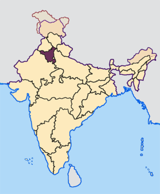
Bhiwani district is one of the 22 districts of the northern Indian state of Haryana. Created on 22 December 1972, it was the largest district of the state by area, before the creation of Charkhi Dadri as a separate district, as it occupied an area of 4,778 square kilometres (1,845 sq mi) and administered 442 villages with a population of 1,634,445. Sirsa is now the largest district of the state.
Rohtak district is a district in the Indian state of Haryana. It is located in the southeast of the state and northwest of Delhi, bounded by Jind and Sonipat districts to the north, Jhajjar and Sonipat districts to the east, and Hissar, Charkhi Dadri, and Bhiwani districts to the west. Rohtak city is the district headquarters.

Jagadhri is a city and a municipal council in the Yamunanagar district of the Indian state of Haryana. This town lies adjacent to the city of Yamunanagar. The demarcation line between the two is difficult to discern. Jagadhri is around 90 km away from Chandigarh, the capital city of Haryana state. This town is known for the cluster of brass and copper industries. Jagadhri is known as the "Brass City" of India.

Sirsa is a city and a municipal council in Sirsa district in the westernmost region of the Indian state of Haryana, bordering Punjab and Rajasthan. It is located near to Thar desert. It is located 250 kilometres north-west of New Delhi and 260 kilometers south-west of state capital Chandigarh. Sirsa's nearest cities include Hisar, Fatehabad, Ellenabad, Bhadra, Nohar, Mandi Dabwali and Hanumangarh. Its history dates back to the time of the Mahabharata. At one time, the Sarasvati River flowed in this area.
For people with the surname, see Barsi (surname).
Nalwa is a village, as well as an Assembly Constituency in Haryana Legislative Assembly, located in Hisar district in the state of Haryana in India.

Assandh, historically known as Āsandīvat, is a town and a municipal committee in Karnal district in the state of Haryana, India. Assandh is located in 45 km south-west of Karnal.
Chhachhrauli is a tehsil and Gram Panchayat town consisting of 20 wards in Yamuna Nagar district in the state of Haryana, India. It is 11 km north-east of Jagadhari. Chachhraulli is often known as "Cherapunjii of Haryana" as it receives the most rain in the whole of Haryana . It was a municipal committee until 1998. Before independence in 1947, it was the capital of the princely state of Kalsia. The origin of word Chhachhrauli is believed to be "Sat Sherawali" due to a temple located near bus terminus.
Jonapur is a census town in South district in the Indian state of Delhi.
Meham, also spelled Maham, is a small city in Rohtak district of the Indian state of Haryana. It is one of the two sub-divisions in Rohtak district. As a tehsil, it is further divided into two community development blocks, Maham and Lakhan-Majra.

Raipur Rani is a census town in Panchkula district in the Indian state of Haryana. It is located on the Panchkula city-Chandigarh-Nahan-Paonta Sahib-Dehradun highway 30 kilometres east from the Chandigarh-Mohali-Panchkula urban cities combine. It is about 20 kilometres from the Dera Bassi Industrial belt and 10 kilometres from the Barwala industrial estate. Narayangarh in the Ambala District is the next large town in its proximity.
Safidon is a city and a municipal committee in Jind district in the Indian state of Haryana.Safidon was anciently known as "Sarp Daman"
Julana is a municipal committee town in the Jind district in the Haryana state of India. It is positioned in the Interior of Haryana and is usually known as the Heart of Haryana. It is the administrative headquarters of Julana Tehsil, located in the middle of Rohtak and Jind on NH 71.
Kheri Sher Khan is a village in Kaithal district in Haryana, India. It is a part of the village Matour. It is the last village of Kaithal towards Jind. The population is about 3000.
Pur is a village in the Bawani Khera tehsil of Bhiwani district in the Indian state of Haryana. It lies on the border with Hisar district, 20 kilometres (12 mi) north of the district headquarters at Bhiwani, 6 kilometres (3.7 mi) west of Bawani Khera and around 240 kilometres (150 mi) from the state capital Chandigarh.
Jamalpur is a village in the Bawani Khera tehsil and Bawani Khera of Bhiwani district in Haryana state of India. It lies approximately 8 kilometres (5.0 mi) north west of Bawani Khera and 25 kilometres (16 mi) south east of the district headquarters town of Bhiwani.
Baliali is a village in Bawani khera tehsil of Bhiwani district of Indian state of Haryana. It lies approximately 15 kilometres (9.3 mi) north west of the district headquarters town of Bhiwani. As of the 2011 Census of India, the village had 2405 households with a population of 12,440 of which 6,562 were male and 5,878 female.
Ratera is a village in the Bhiwani district of the Indian state of Haryana. Its old name is Ratangarh. It lies approximately 38 kilometres (24 mi) of the district headquarters town of Bhiwani. As of the 2011 Census of India, the village had 1,039 households with a population of 5,572 of which 2,923 were male and 2,649 female.
Siwara is a village in the Bawani Khera tehsil of the Bhiwani district in the Indian state of Haryana. It lies approximately 19 kilometres (12 mi) north of the district headquarters town of Bhiwani. As of the 2011 Census of India, the village had 760 households with a population of 4,176 of which 2,211 were male and 1,965 female.
Kharak Khurd is a village in the Bhiwani district of the Indian state of Haryana. It lies approximately 20 kilometres (12 mi) north east of the district headquarters town of Bhiwani.


