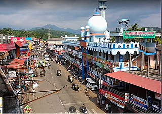
Eyyal

Last updated

Eyyal
Village
India Kerala location map.svg
Red pog.svg
Eyyal
Location in Kerala, India
India location map.svg
Red pog.svg
Eyyal
Eyyal (India)
Coordinates: 10°39′0″N76°7′0″E / 10.65000°N 76.11667°E / 10.65000; 76.11667
CountryFlag of India.svg  India
State Kerala
District Thrissur
Population
 (2011)
  Total6,727
Languages
  Official Malayalam, English
Time zone UTC+5:30 (IST)
PIN
680501
Telephone Code04885
Vehicle registration KL48
Nearest CityKunnamkulam
Lok Sabha ConstituencyAlathur
Vidhan Sabha ConstituencyKunnamkulam
Website eyyal.blogspot.com

Eyyal is a village in Thrissur District in the state of Kerala, India. [1] Archeologists have unearthed a collection of old Roman coins in 1946. These coins date from 123 BC to 117 AD. These coins currently exhibited in the Archeological Museum of Thrissur.

Contents

Population, religion, caste, working data

Eyyal is a Census Town city situated in Talappilly taluka of Thrissur district. As per the Population Census 2011, there are total 1,579 families residing in the Eyyal city. The total population of Eyyal is 6,727 out of which 3,097 are males and 3,630 are females thus the Average Sex Ratio of Eyyal is 1,172.

The population of Children of age 0–6 years in Eyyal city is 776 which is 12% of the total population. There are 383 male children and 393 female children between the age 0–6 years. Thus as per the Census 2011 the Child Sex Ratio of Eyyal is 1,026 which is less than Average Sex Ratio (1,172).

As per the Census 2011, the literacy rate of Eyyal is 94.2%. Thus Eyyal has lower literacy rate compared to 95.1% of Thrissur district. The male literacy rate is 84.3% and the female literacy rate is 82.6% in Eyyal.

Population 6,727

Literacy 94.2%

Sex Ratio 1,172

Eyyal Census Town has total administration over 1,579 houses to which it supplies basic amenities like water and sewerage. It is also authorize to build roads within Census Town limits and impose taxes on properties coming under its jurisdiction.

Census Town

As per the Population Census 2011 data, following are some quick facts about Eyyal Census Town.

TotalMaleFemale
Children776383393
Literacy94.2%84.3%82.6%
Scheduled Caste906443463
Scheduled Tribe413
Illiterate1,118485633

Caste-wise population

Schedule Caste (SC) constitutes 13.5% while Schedule Tribe (ST) were 0.1% of total population in Eyyal.

TotalMaleFemale
Schedule Caste906443463
Schedule Tribe413

Religion-wise population

ReligionTotalMaleFemale
Hindu4,245(63.1%)1,9972,248
Muslim1,904(28.3%)8241,080
Christian573(8.52%)275298
Sikh1(0.01%)01
Buddhist1(0.01%)01
Jain0(0%)00
Other Religion0(0%)00
No Religion Specified3(0.04%)12

Literacy rate

The total literacy rate of Eyyal was 94.25% in 2011 which is greater than average literacy rate 94% of Kerala. Population-wise, out of total 5,609 literates, males were 2,612 while females were 2,997. Also the male literacy rate was 96.24% and the female literacy rate was 92.59% in Eyyal.

EyyalKerala
Female92.59%92.07%
Male96.24%96.11%
Total94.25%94%

Sex ratio

The Sex Ratio of Eyyal is 1,172. Thus per every 1000 men there were 1,172 females in Eyyal. Also as per Census, the Child Sex Ration was 1,026 which is less than Average Sex Ratio ( 1,172 ) of Eyyal.

Child population

According to Census 2011, there were 776 children between age 0 to 6 years in Eyyal. Out of which 383 were male while 393 were female.

Working population

In Eyyal Census Town out of total population, 2,417 were engaged in work activities. 82% of workers describe their work as Main Work (Employment or Earning more than 6 Months) while 18% were involved in Marginal activity providing livelihood for less than 6 months. Of 2,417 workers engaged in Main Work, 142 were cultivators (owner or co-owner) while 119 were Agricultural labourer.

TotalMaleFemale
Main Workers1,9811,500481
Cultivators14211230
Agriculture Labourer1197049
Household Industries392712
Other Workers1,6811,291390
Marginal Workers436222214
Non Working4,3101,3752,935

Wards

A ward is a local authority area, typically used for electoral purposes. Eyyal is further divided into 1 ward where elections are held every 5 years.

#WardPopulationLiteracySex Ratio
1Ward No - 16,72783.4%1,172

Related Research Articles

<span class="mw-page-title-main">Erattupetta</span> Municipality in Kerala, India

Erattupetta is a municipality in the Kottayam district of Kerala, India. It is located 29 km (18.0 mi) east of the district headquarters in Kottayam and about 133 km (82.6 mi) north of the state capital Thiruvananthapuram. As per the 2011 Indian census, Erattupetta has a population of 34,814 people, and a population density of 1,906/km2 (4,940/sq mi).

Barpeta Road or Athiyabari as known earlier is a town and Commercial City of Assam a municipal board in Barpeta district in the state of Assam, India.

Nallur (Nalloor) is a panchayat town in Kanniyakumari district in the Indian state of Tamil Nadu.

Sewalkhas is a town and a Nagar Panchayat in Meerut district in the Indian state of Uttar Pradesh.

Akividu is a town in West Godavari district of Andhra Pradesh, India. It is a nagara panchayati (municipality) and the mandal headquarters of Akiveedu mandal in Bhimavaram revenue division. Akiveedu is a sixth biggest town in former West Godavari district between the cities of Bhimavaram and Eluru.
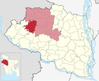
<span class="mw-page-title-main">Niamatpur Upazila</span> Upazila in Rajshahi, Bangladesh

Niamatpur is an upazila of Naogaon District in the Division of Rajshahi, Bangladesh.

Mullipallam is a panchayat village in Vadipatti Taluka of Madurai district, Tamil Nadu, India, with a total of 2173 families residing.

Kodamthuruth is a village in Alappuzha district in the Indian state of Kerala. It is a panchayat, which comes under the Aroor Assembly constituency.

Mulavana is a village in Kollam district in the state of Kerala, India. The place is filled with almost all types of shops,which includes stationary,fancy,textile etc. The Mulavana fish market is regarded as the best market while comparing with the surrounding places.

<span class="mw-page-title-main">Vazhayur</span> Census town in Kerala, India

Vazhayur is a census town in Malappuram in the state of Kerala, India. The Vazhayur Census Town has population of 36,909 of which 18,163 are males while 18,746 are females as per report released by Census India 2011. The 2018 Malayalam film Sudani from Nigeria was shot in Vazhayur. The town forms a portion of the Malappuram metropolitan area.

Perumpetty is a census village in Kottanad gram panchayat in the Mallapally taluk of the district of Pathanamthitta in Kerala. As of 2011, it had a population of 14,396.

Vilavoorkkal is a Census Town city in district of Thiruvananthapuram, Kerala. The Vilavoorkkal Census Town has population of 31,761 of which 15,647 are males while 16,114 are females as per report released by Census India 2011.Vilavoorkkal used to be a village in Thiruvananthapuram district in the state of Kerala, India but was upgraded to census town after reclassification.

Khujner is a town and a nagar panchayat in Rajgarh district in the Indian state of Madhya Pradesh. Khujner also called Khatu of Malwa. 465687 is Pin Code of Khujner.

Katamalli is a village in Belgaum district in Karnataka, India.

Heirok is a town and a nagar panchayat in Thoubal district in the Indian state of Manipur.

Talwandi Madho is a village in Nakodar in Jalandhar district of Punjab State, India. It is located 17 kilometres (11 mi) from Nakodar, 23 kilometres (14 mi) from Kapurthala, 31 kilometres (19 mi) from district headquarter Jalandhar and 180 kilometres (110 mi) from state capital Chandigarh. The village is administrated by a sarpanch who is an elected representative of village as per Panchayati raj (India). Lambardar of this village is Sukhpreet Singh
<span class="mw-page-title-main">Sainthal, Uttar Pradesh</span> Nagar panchayat in Uttar Pradesh, India

Sainthal is a nagar panchayat in Nawabganj tehsil, Bareilly district, Uttar Pradesh, India.

Korhalli is a large village located in Almel Taluk in Bijapur District of Karnataka State, India.

Gokavaram Mandal is one of the 19 mandals in East Godavari District of Andhra Pradesh. As per census 2011, there are 14 villages.

Junona is a village located in Pauni Taluka of Bhandara district in Maharashtra, India

References

  1. "Census of India: Villages with population 5000 & above". Registrar General & Census Commissioner, India. Archived from the original on 8 December 2008. Retrieved 10 December 2008.{{cite web}}: CS1 maint: others (link)